Irish Hill and Mountain Names
The following document is extracted from the database used to prepare the list of peaks included on the ‘Summits’ section and other sections at www.mountainviews.ie
The document comprises the name data and key geographical data for each peak listed on the website as of May 2010, with some minor changes and omissions. The
geographical data on the website is more comprehensive.
The data was collated over a number of years by a team of volunteer contributors to the website. The list in use started with the 2000ft list of Rev. Vandeleur (1950s),
the 600m list based on this by Joss Lynam (1970s) and the 400 and 500m lists of Michael Dewey and Myrddyn Phillips. Extensive revision and extra data has been
accepted from many MV contributors including Simon Stewart, Brian Ringland, Paul Donnelly, John FitzGerald, Denise Jacques, Colin Dalton, Brendan O'Reilly, Mark
Brennan, myself and others.
I have been gathering the place-name data and other information presented in columns 2-4 from 2004 onwards, and some changes have also been made to the
anglicised forms given in column 1 as a result of this research. The anglicised forms are taken from the highest available authority, namely the Placenames Branch
(An Brainse Logainmneacha), followed the Ordnance Survey maps. In the vast majority of cases, these are in agreement, but there are occasional differences, and
some typographical errors occur on the 1:50,000 maps. A different anglicised form from that shown in these official sources has been adopted only in exceptional
cases, which mainly fall into two categories. Firstly, the cartographers had a habit of adding the word ‘mountain’ to the names of several peaks during the first
Ordnance Survey in the 1830s and 1840s, e.g. Errigal Mountain, Muckish Mountain, Sawel Mountain, Mangerton Mountain, etc. These tend to be principal peaks in
the area in which they are located. This tendency has been ignored in the Mountain Views list for a number of reasons: the word ‘mountain’ is redundant in these
cases as the name already denotes a peak without it (unlike, say, Stradbally Mountain, where Stradbally on its own denotes a parish and village); there is usually no
equivalent word in the Irish form, such as sliabh or cnoc; and the Ordnance Survey forms have not gained currency locally or amongst hill-walkers. The second group
of exceptions concerns hills for which there was substantial evidence from alternative authoritative sources for a name other than the one shown on OS maps, e.g.
Croaghonagh / Cruach Eoghanach in Co. Donegal, marked on the Discovery map as Barnesmore, or Slievetrue in Co. Antrim, marked on the Discoverer map as Carn
Hill. In some of these cases, the evidence for overriding the map forms comes from other Ordnance Survey sources, such as the Ordnance Survey Memoirs. It should
be emphasised that these exceptions represent only a very small percentage of the names listed and that the forms used by the Placenames Branch and/or OSI/OSNI
are adopted here in all other cases.
Wherever possible, the Irish forms in column 3, ‘Name Origin and Meaning’, are also taken from www.logainm.ie, the website of the Placenames Branch, or from OSI
maps (OSNI does not provide Irish forms on its Discoverer Series), but many peaks are only marked in an anglicised form. Therefore, there was a greater reliance on
other authoritative sources, such as regional place-name surveys and works on local history. These sources are cited in square brackets after the Irish form of the
name. See below for the key to the abbreviations used. An original interpretation has only been offered for certain transparent names for which no published source
has been found. These are marked with my initials: [PDT]. The Irish forms, which sometimes reflect dialect or Classical Irish forms, have sometimes been modified for
consistency to give a standardised modern Irish form. The English translations have also been standardised (e.g. so that Ir. binn is consistently rendered as ‘peak’),
and are therefore not necessarily exactly as provided in the source quoted for the Irish form, although great importance has been attached to these. They have only
been disregarded where there is compelling evidence for an alternative interpretation.
The information presented in column 4, Notes about peak and name(s), is very varied in nature. Often it consists of a discussion of the name or an explanation of the
interpretation provided. However, it may also include information relating to the topography, history, mythology, folklore, archaeology or other aspects of the mountain.
Some information has also been added on published descriptions of walking routes, particularly for peaks which are not generally well covered in walking guides.
Column 5, ‘Area’, refers to the system of areas used for the MV list. In order to ensure that every peak is assigned to an area, the classification is somewhat
pragmatic. For example, Slieve Croob and its satellites are listed under Mourne Mountains rather than having an area of their own. Isolated hills in areas that are
generally flat have been assigned to areas with names specially coined for MV, such as ‘North Midlands’. On the website there is an additional field called ‘Sub-area’
which enables further distinctions to be made, but this is not given here due to limited space. Therefore, this data should not be interpreted too literally.
Comments on the list are welcome and notification of errors and omissions gratefully received.
Paul Tempan, May 2010. Revised February 2012.
Key to Abbreviations for Place-Name Sources
AMacAB Unpublished notes on the element sliabh in Irish Place-names - Alan Mac An Bhaird
Aspell 'Hags, Hounds and Hornless Cows: Decoding Irish Mountain Names', - Liam Aspell, Call Out, March 2011, www.mountainrescue.ie
Buile Shuibhne Buile Shuibhne (‘The Frenzy of Sweeney’) – edited and translated by James G. O’Keeffe
CF Cois Feoire (place-names of Co. Kilkenny) - Eoghan Ó Ceallaigh
CMcG An Fear Deireanach den tSloinneadh / The Last of the Name - Charles McGlinchey
DCM Dictionary of Celtic Mythology – James MacKillop
Dinneen Foclóir Gaedhilge agus Béarla / Irish-English Dictionary – Rev. Patrick S. Dinneen
DUPN A Dictionary of Ulster Place-Names - Patrick McKay
ET Éire Thuaidh / Ireland North - a cultural map and gazetteer of Irish place-names, published by the Ordnance Survey of Northern Ireland
GE Gasaitéar na hÉireann - Ordnance Survey of Ireland
GUH Gleanings from Ulster History – Séamas Ó Ceallaigh
HDGP Historical Dictionary of Gaelic Placenames – edited by Pádraig Ó Riain, Diarmuid Ó Murchadha & Kevin Murray
HU A Hidden Ulster - Pádraigín Ní Uallacháin
IPN Irish Place Names - Deirdre Flanagan and Laurance Flanagan
JOK James O'Kane - article on placenames of Inishkeel and Kilteevoge parishes in Zeitschrift für Celtische Philologie
JON John O’Neill – unpublished thesis on the Placenames of Glencolumbkille.
LL Liostaí Logainmneacha - An Brainse Logainmneacha. Available for counties Limerick, Louth, Waterford and Monaghan, Offaly and Tipperary.
logainm.ie Bunachar Logainmneacha na hÉireann, the Placenames Database of Ireland, a website developed by Fiontar at DCU on behalf of the Placenames
Branch (Department of Community, Rural and Gaeltacht Affairs). URL: www.logainm.ie
MacNeill The Festival of Lughnasa - Máire MacNeill
MD Metrical Dindshenchas - edited by Edward Gwynn
MNIMA ‘Minor Names in an Irish Mountain Area’ – an article by Breandán S. Mac Aodha, published in Studia Celtica vol. 24-25 (1989-90), pp. 141-152.
MÓM ‘The Mountain Names of County Down’, Mícheál Ó Mainnín, in Nomina 17 (1994) 31-53.
NIPNP Replies Replies from the Northern Ireland Place-Name Project to enquiries from the public.
O’Flaherty A chorographical description of West or H-Iar Connaught – Roderic O’Flaherty
OG Onomasticon Goedelicum - Edmund Hogan
OSI Ordnance Survey of Ireland maps (usually from the Discovery Series, 1:50,000, unless otherwise stated)
OSM Ordnance Survey Memoirs
OSNB Ordnance Survey Name Book - with Irish versions mainly proposed by John O'Donovan
PDT Suggested Irish version proposed by Paul Tempan in the absence of other published sources
PJW (The Origin and History of) Irish Names of Places (3 vols) – Patrick Weston Joyce
PNABD Place Names and Antiquities of the Barony of Duhallow – Michael J. Bowman
PNCC Place Names of Co. Carlow – Edward O’Toole
PNCL Place-Names of Co. Leitrim - Rev. John Pinkman
PNCW Place-Names of County Wicklow - Liam Price
PND Place-Names of Decies - Canon Patrick Power
PNNI Place-Names of Northern Ireland - published by the Institute of Irish Studies, Queen's University Belfast, esp. volume III (The Mournes) by Mícheál Ó
Mainnín.
Siúlóidí Acla Siúlóidí Acla / A Bilingual Guide to Walking in Achill
SOD Dinnseanchas na gCruacha - Seoirse Ó Dochartaigh
Stubbs ‘Place Names in the County of Louth’ – a series of articles by Major Gen. F.W. Stubbs, published in the County Louth Archaeological Journal, Vol. 2
(no.1, 2, 3 & 4).
SWoI Walk Guide: South-West of Ireland – Seán Ó Súilleabháin
TCCD Tríocha-Céad Chorca Dhuibhne - An Seabhac (Pádraig Ó Siochfhradha)
TH Toponomia Hiberniae (4 vols), a survey of the place-names of South Kerry – Breandán Ó Cíobháin
TNCT Townland Names of County Tyrone – Patrick M’Aleer
TR Connemara, map and gazetteer - Tim Robinson
T6000 map of Beara by Eoghan Ó Súilleabháin in Tuosist 6000
UR Logainmneacha Uíbh Ráthach - An Seabhac (Pádraig Ó Siochfhradha)
An asterisk (*) indicates that no name has been found for the peak on OS maps or in other authoritative sources. The name given here has been adopted specially for the Mountain
Views list, but should not be regarded as official. In most cases the name adopted is that of a townland or one derived from some nearby landmark. Since such names are not official,
Irish forms have not been provided in these cases, even where available. Since the first Mountain Views list was compiled, authoritative names have been found for a considerable
number of peaks which are unnamed on OS maps, and it is hoped that more names will emerge from research in the future.
A hash sign (#) after the source abbreviation indicates that the Irish version provided here is not exactly the form in the source quoted. A common reason for this is that the source
gives a form in dialect or in Classical Irish, whereas the version provided here has been adjusted to conform to standard modern Irish. The definite article has also been added to
certain names to produce standardised forms, e.g. Binn Riabhach has been changed to An Bhinn Riabhach.
A double dagger (‡) after the source abbreviation indicates that the version provided here is inferred from a related name in the source cited.
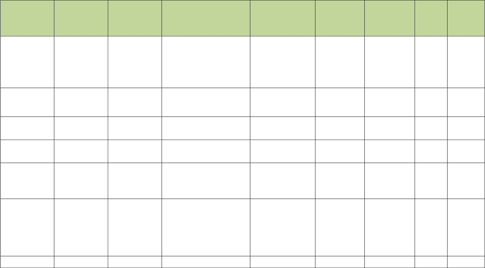
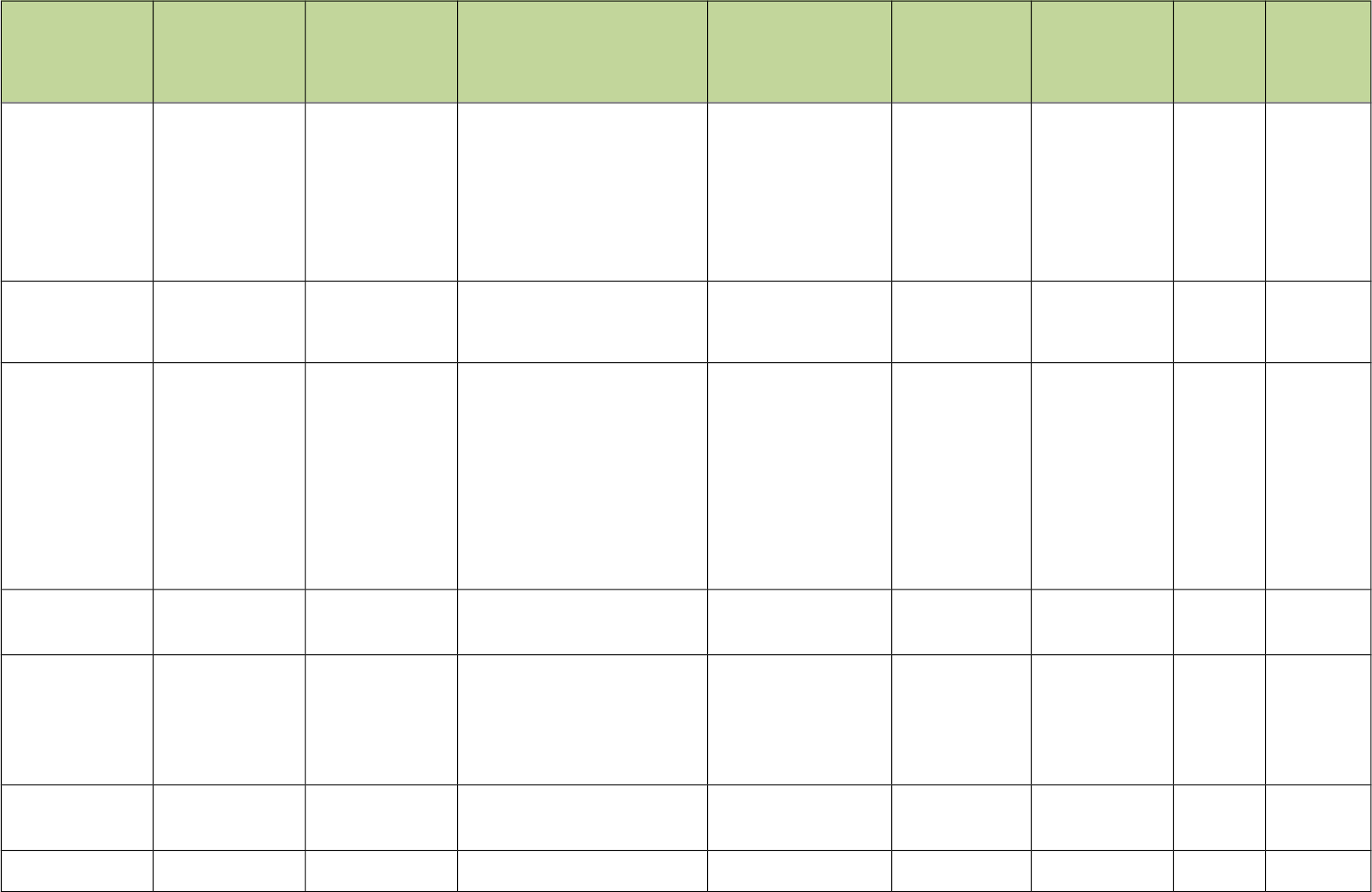
Anglicised
Name(s) (or
Irish name
where not
available)
Irish Name(s)
(where
available)
Name Origin
and Meaning
Notes about peak and
name(s)
Area County Grid Ref.
Height (in
metres)
1:50,000
Map Sheet
Abbey Hill Cnoc na
Mainistreach
(Ir. Cnoc na
Mainistreach
[logainm.ie], 'hill
of the abbey')
The name refers to Corcomroe
Abbey, which is located on the south
side of the hill, near Bell Harbour
(Bealaclugga). Walks: for a walk to
the summit of Abbey Hill and around
the N slopes, see Kevin Corcoran,
West of Ireland Walks, 43-50, or
Whilde & Simms, New Irish Walk
Guide - West and North, 24-25.
West Clare Clare M300 103 240 51
Addernymore An Eadarna
Mhór
(Ir. An Eadarna
Mhór [OSI], 'the
big [obscure
element]')
Donegal NW Donegal B899 152 416 1
Aganny Top*
This peak is near Lough Aganny. It
is unnamed on the Discovery map.
Any information on its correct name
would be welcome.
Dartry Mountains Leitrim G844 488 482 16
Aghalateeve*
Aghalateeve is a townland in the
parish of Rossinver. Any information
on the correct name of this peak
would be very welcome.
Dartry Mountains Leitrim G822 490 432 16
Aghla Beg An Eachla
Bheag
(Ir. An Eachla
Bheag [OSI],
poss. 'little look-
out
point/prospect')
Donegal NW Donegal B962 253 564 2
Aghla Beg
(South)
For origin of
name, see Aghla
Beg.
Although this peak is higher than
either of its neighbours, Aghla More
or Aghla Beg, it has always
remained unnamed on Ordnance
Survey maps. As it has never even
been marked with a spot height on
the 6 inch map, it seems likely that it
was omitted because of a failure to
realise that it was the highest peak in
the group.
Donegal NW Donegal B965 246 603 2
Aghla More An Eachla Mhór (Ir. An Eachla
P.W. Joyce, interprets this name as
Ir. eachla or eachlann, 'stable',
Donegal NW Donegal B950 239 584 1
Anglicised
Name(s) (or
Irish name
where not
available)
Irish Name(s)
(where
available)
Name Origin
and Meaning
Notes about peak and
name(s)
Area County Grid Ref.
Height (in
metres)
1:50,000
Map Sheet
Mhór [DUPN],
poss. 'great look-
out
point/prospect')
suggesting it is an example of a
mountain named after a feature
situated at its foot. However, Patrick
McKay prefers to see the modern
form as a re-interpretation of the
original name Achla, a form of Aichill,
meaning 'a look-out point or
prospect' (Dictionary of Ulster Place-
Names). Achill Island in Mayo (Ir.
Acaill) may well be derived from the
same root.
Aghla Mountain An Eachla (Ir. An Eachla
[DUPN], poss.
'look-out
point/prospect')
Bluestack Mountains Donegal G897 989 593 11
Agnew's Hill
Agnew's Hill is probably the peak
marked as Benwellerorie on
Mercator's map of SE Ulster, 1595.
Rory's Glen is a townland on the SE
slopes, named after Rory Ogue
McQuillan [OSM, vol. x, p. 118].
Benwellerorie may represent an
anglicisation of *Binn Mhaol Ruairí,
'Rory's bare peak'. The English
name is derived from the Agnews (Ir.
Ó Gníomh), a family of Scottish
stock who came to prominence in
this area in the 17th century after the
decline of the McQuillan's fortunes.
Antrim Hills Antrim D327 017 474 9
Agow Top*
This peak is near Lough Agow. It is
unnamed on the Discovery map.
Any information on its correct name
would be welcome.
Dartry Mountains Leitrim G865 472 423 16
Altnapaste Allt na Péiste (Ir. Allt na Péiste
[OSI], 'ravine of
the
serpent/monster'
)
The summit is located on the
boundary of the townlands of
Altnapaste, Ballybobaneen and
Cashel. It is not clear from maps
where the ravine is which gave name
to the mountain and the townland.
There is a ledge and cliff to the east
of the summit named Altmore Cliff.
Bluestack Mountains Donegal H045 960 364 6/11
An Bheann Mhór
(Ir.)
An Bheann Mhór (Ir. An Bheann
Mhór [TH], 'the
big peak')
This peak is unnamed on OS maps.
It is recorded as An Bheann Mhór in
Toponomia Hiberniae by Breandán Ó
Cíobháin.
Dunkerron
Mountains
Kerry V655 646 308 83/84
An Bheann Mhór
(Ir.)
An Bheann Mhór (Ir. An Bheann
Mhór [TH], 'the
Dunkerron
Mountains
Kerry V593 684 675 83
Anglicised
Name(s) (or
Irish name
where not
available)
Irish Name(s)
(where
available)
Name Origin
and Meaning
Notes about peak and
name(s)
Area County Grid Ref.
Height (in
metres)
1:50,000
Map Sheet
big peak')
An Bhinn Dubh
(Ir.)
An Bhinn Dubh (Ir. An Bhinn
Dubh [OSI], 'the
black peak')
This is the first peak W of the
Connor Pass.
Brandon Group Kerry Q484 056 478 70
An Bhinn Láir
(Ir.)
An Bhinn Láir (Ir. An Bhinn Láir
[TH], 'the middle
peak')
Located at the top of the ridge
separating the valleys of Derriana
from Cloonaghlin.
Dunkerron
Mountains
Kerry V630 714 514 78/83
An Cnapán Mór
(Ir.)
An Cnapán Mór;
An Sliabh Dubh
(Ir. An Cnapán
Mór [OSI,
TCCD], 'the big
lump')
An Seabhac also gives the
alternative name An Sliabh Dubh
[TCCD], 'the black mountain'.
Central Dingle Kerry Q522 045 649 70
An Cnoc
Riabhach (Ir.)
An Cnoc
Riabhach
(Ir. An Cnoc
Riabhach [TH],
'the grey/striped
hill')
This is the first peak in the
horseshoe walk which takes in
Mullaghanattin and Beann (going
anti-clockwise).
Dunkerron
Mountains
Kerry V758 760 534 78
Anglesey
Mountain
"Called after the Marquess of
Anglesea, who till the middle of the
last century [i.e. 19th century] owned
it." [Stubbs]
Cooley/Gullion Louth J106 178 428 29
Annagh Hill
Annaghhill is also the name of a
townland in the parish of Kilnahue.
There are six other townlands in the
parish whose names begin with
Annagh. This hill is marked as
Conna Hill on some 19th century
maps of Co. Wexford. Connahill is
the name of a townland to the SW of
the summit.
Dublin/Wicklow Wexford T100 680 454 62
Annacoona Top*
Annacoona Cliffs, which form a
dramatic barrier at the head of
Gleniff, are immediately north of the
summit. A cavern, known as
Diarmuid and Gráinne's Cave, is
situated in these cliffs.
Dartry Mountains Sligo G728 463 597 16
Annatoran*
Annatoran is the highest part of the
plateau located ENE of Easky
Lough.
Ox Mountains Sligo G475 245 512 24
Arderin Ard Eireann (Ir. Ard Éireann
[logainm.ie], 'the
height of Ireland'
or 'Eriu’s height')
See Máire MacNeill, 'The Festival of
Lughnasa' (pp. 221-25) for details of
the festive assembly on 'Height
Sunday' on Arderin.
Slieve Bloom Laois / Offaly S232 989 527 54
Ardloughnabrack
baddy
Ard Loch na
mBreac Beadaí
(Ir. Ard Loch na
mBreac Beadaí
This peak is a small knoll between
Lough Nabrackbaddy (Loch na
Donegal NW Donegal B955 245 473 1
Anglicised
Name(s) (or
Irish name
where not
available)
Irish Name(s)
(where
available)
Name Origin
and Meaning
Notes about peak and
name(s)
Area County Grid Ref.
Height (in
metres)
1:50,000
Map Sheet
[OSI‡], 'height of
Loch na mBreac
Beadaí or lake of
the tasty trout')
mBreac Beadaí) and Lough Feeane.
The name is correctly positioned on
Discovery sheet 1, but incorrectly on
sheet 2 (on which it should not
appear).
Ardnageer;
Knockgorm
Ard na gCaor (Ir. Ard na gCaor
[JOK], 'height of
the berries')
Bluestack Mountains Donegal G969 909 642 11
Ardnageer SW
Top
For origin of
name, see
Ardnageer
Bluestack Mountains Donegal G963 905 626 11
Arroo Mountain Sliabh Aradh (Ir. Sliabh Aradh
[logainm.ie],
'mountain of
[obscure
element]')
Arroo is a townland in Rossinver
parish, barony of Rosclogher.
Dartry Mountains Leitrim G833 521 523 16
Balbane Hill
This peak is a southern outlier of
Crocknapeast.
Donegal SW Donegal G696 829 472 10
Balix Hill
Balix is a townland name but is
derived from (Ir. Béalóga, 'narrow
gap(s)' [inferred from HDGP].
Sperrin Mountains Tyrone H475 962 403 13
Ballaghnabehy
Top
This peak is unnamed on the
Discovery map. It is near
Ballaghnabehy Lough and is part of
the Ben Scardaun / Lackagh
Mountain massif. Any information on
its correct name would be welcome.
Ballaghnabehy is a townland in the
parish of Cloonclare.
Dartry Mountains Leitrim G946 352 413 26/16
Ballinacor
Mountain
Sliabh Bhaile na
Corra
(poss. Ir. Sliabh
Bhaile na Corra
[PDT], 'hill of
Baile na Corra or
the townland of
the weir')
Ballinacor is the name of a townland,
a parish and two baronies (Ballinacor
South and North), which shows that
it was historically of considerable
importance, even though there is no
village of the name. Ballinacor has
in turn been the seat of the Anglicus
family (14th century), the O'Byrnes
of Gabhal Raghnaill, the Rawdon
family and the Kemmis family (until
1986, since when it has changed
hands several times).
Dublin/Wicklow Wicklow T117 865 531 62
Ballinafunshoge;
Slieve Buck
Sliabh Boc (prob. Ir. Sliabh
Boc [PDT],
'mountain of
Ballinafunshoge (from Ir. Baile na
Fuinseoige, 'townland of the ash') or
Ashtown is the name of a townland,
and it has clearly been erroneously
Dublin/Wicklow Wicklow O165 042 480 56
Anglicised
Name(s) (or
Irish name
where not
available)
Irish Name(s)
(where
available)
Name Origin
and Meaning
Notes about peak and
name(s)
Area County Grid Ref.
Height (in
metres)
1:50,000
Map Sheet
bucks')
applied to this hill. The peak was
named Slieve Buck on maps of
Wicklow made in 1760 and in 1822,
but this name appears to have been
forgotten since. In his 'Guide to the
County of Wicklow' (1827) Wright
gives its height as 1480 ft., which is
a little low for this peak (1582 ft.), but
corresponds to the height of
Sleamaine, located about 1 mile
further N. In any case, at this time
such heights were estimated by
enthusiasts and were often not very
accurate.
Ballinard*
Ballinard is a townland in the parish
of Ballincuslane. Any information on
the correct name of this peak would
be very welcome.
W Limerick / N Kerry Kerry R083 118 410 72
Ballincurra Hill Cnoc Bhaile an
Charraigh
(Ir. Cnoc Bhaile
an Charraigh
[OSI], 'hill of
Baile an
Charraigh')
The gap between Ballincurra Hill and
Cooneen Hill is known as Ormond
Stile (sometimes Ormond Style). It
is mentioned by John O'Donovan as
the northern limit of Sliabh Eibhlinne
(Slieve Felim), and he calls it Céim
Urmhumhain, 'the step of Ormond'.
It is on the southern boundary of the
barony of Upper Ormond.
Shannon Tipperary R924 698 403 59
Ballineddan
Mountain
Sliabh Bhuaile
an Fheadáin
(Ir. Sliabh
Bhuaile an
Fheadáin [OSI],
'mountain of
Ballineddan')
Ballineddan Mountain is a townland.
The name is derived from Buaile an
Fheadáin meaning 'milking place of
the stream'.
Dublin/Wicklow Wicklow T002 908 652 56
Ballyarthur Hill;
Lisnalanniv Hill
Cnoc Bhaile
Artúir
(poss. Ir. ‡Cnoc
Bhaile Artúir
[PDT], 'hill of
Baile Artúir')
Named Lisnalanniv Hill on the old ½"
series. Ballyarthur is a townland in
the parishes of Marshalstown and
Fermoy, barony of Condons and
Clangibbon. The Irish form of this
name is Baile Artúir [logainm.ie].
Ballyhoura
Mountains
Cork/Limerick
(though
summit in
Cork)
R790 179 355 73
Ballycumber Hill Cnoc Bhaile an
Chumair
(poss. Ir. Cnoc
Bhaile an
Chumair [PDT],
'hill of Baile an
Chumair or the
townland of the
ravine')
Ballycumber North and South are
townlands in the parish of
Kilcommon.
Dublin/Wicklow Wicklow T028 758 431 62
Anglicised
Name(s) (or
Irish name
where not
available)
Irish Name(s)
(where
available)
Name Origin
and Meaning
Notes about peak and
name(s)
Area County Grid Ref.
Height (in
metres)
1:50,000
Map Sheet
Ballycurragh Hill;
Rathhinder
Dublin/Wicklow Wicklow T057 823 536 62
Ballydavid Head Ceann Bhaile
Dháith
(Ir. Ceann Bhaile
Dháith [An tOrdú
Logainmneacha
(Ceantair
Ghaeltachta)
2008], 'head(-
land) of Baile
Dháith')
This headland, along with the Three
Sisters and Sybil Head on the other
side of Smerwick Harbour, are
remnants of a chain of hills that were
worn down by glacial action and
eventually broken through by the
sea.
Dingle West Kerry Q387 113 247 70
Ballykildea
Mountain
Sliabh Bhaile
Mhic Giolla Dé
(poss. Ir. ‡Sliabh
Bhaile Mhic
Giolla Dé [PDT],
'mountain of
Baile Mhic Giolla
Dé')
Ballykildea is a townland in the
parish of Killaloe.
Shannon Clare R662 737 412 58
Ballysitteragh An Scraig; Cnoc
Bhaile Uí Shé
(Ir. An Scraig
[TCCD], 'rocky
outcrop')
Also known as Cnoc Bhaile Uí Shé
[OSI], 'hill of Baile Uí Shé', from
Ballyhea(-bought) townland. The
English form Ballysitteragh could be
from be Baile Suiteoireach, 'the
townland of the camp/barracks', but
the circumstances of its naming are
unclear. Coumhenry, Coumgraig
and Coumthrive are hollows below
the mountain on the N. side.
Brandon Group Kerry Q460 057 623 70
Ballyteige*
Ballyteige is a townland in the parish
of Moyne. Any information on the
correct name of this peak would be
very welcome.
Dublin/Wicklow Wicklow T062 844 447 62
Ballyvouskill*
Ballyvouskill is a townland in the
parish of Drishane. Any information
on the correct name of this peak
would be very welcome.
Paps/Derrynasaggar
t
Cork W258 853 401 79
Baltinglass Hill Cnoc Bhealach
Conglais
(poss. Ir. ‡Cnoc
Bhealach
Conglais [PDT],
'hill of Bealach
Conglais')
There is a hillfort on summit named
Rathcoran and a second one to NW.
The entry in PNCW for Rathcoran
refers to an article on "The
Excavation of a Burial Cairn on
Baltinglass Hill" in PRIA xlvi (1941),
p. 221. This makes it clear that
Baltinglass Hill is the English name
of this height.
Dublin/Wicklow Wicklow S885 892 382 61
Baraveha Barr an Bheithe (prob. Ir. Barr an W Limerick / N Kerry Kerry R112 086 451 72
Anglicised
Name(s) (or
Irish name
where not
available)
Irish Name(s)
(where
available)
Name Origin
and Meaning
Notes about peak and
name(s)
Area County Grid Ref.
Height (in
metres)
1:50,000
Map Sheet
Bheithe [PDT],
'hill-top of the
birch')
Barcam
This peak is immediately north of the
Glendine Gap and is unnamed on
the Discovery map. Any information
on its correct name would be
welcome. Barcam is a townland in
the parish of Kinnitty.
Slieve Bloom Offaly N228 000 484 54
Barnacuillew Barr na
Coilleadh
(Ir. Barr na
Coilleadh
[logainm.ie], 'top
of the wood')
This hill is unnamed on OS maps.
The names Lengad (recte Glengad)
or Dooncarton and Barnacuille (recte
Barnacuillew) which appear on the
Discovery map are townlands.
Barnacuillew is derived from Ir. Barr
na Coilleadh [logainm.ie], 'top of the
wood', and is therefore likely to have
referred originally to a hill. William
Bald's map of Co. Mayo (1830) gives
the name Gubbin (prob. Ir. Gobán,
'little beak') for the SW spur which
corresponds to the 233m spot
height.
North Mayo Mayo F811 375 260 22
Barnahowna Mám Cam (prob. Ir. Mám
Cam [PDT],
'crooked pass')
This peak is unnamed on OS maps
but is named Maume Camb on
Bald's map of Co. Mayo (1830). A
spur descending to the NNE is called
Knockmuredamore. Barnahowna is
a townland name. Also called
Naweelion.
Partry/Joyce Country Mayo M002 675 516 38
Barnanageehy Bearna na
Gaoithe
(prob. Ir. Bearna
na Gaoithe
[PDT], 'gap of
the wind')
This is one of the most common
names for a pass in Ireland. The
name is actually marked on lower
peaks to the E, and it seems likely
that the gap in question is even
further to the E.
Slieve Mish Kerry Q800 082 561 71
Barnastooska Barr na Stuaice (Ir. Barr na
Stuaice
[logainm.ie], 'top
of the peak')
Barnastooska is the name of a
townland in the parish of Kilgarvan.
Shehy/Knockboy Kerry W049 713 497 79
Barnes Top
Also referred to as Barness in the
Ordnance Survey Memoirs.
Sperrin Mountains Derry/Londond
erry
H638 999 456 13
Barraboy
Mountain
Cnoc Bharr Buí (Ir. Cnoc Bharr
Buí [OSI], 'hill of
Barr Buí or
Shehy/Knockboy Kerry V938 608 460 85
Anglicised
Name(s) (or
Irish name
where not
available)
Irish Name(s)
(where
available)
Name Origin
and Meaning
Notes about peak and
name(s)
Area County Grid Ref.
Height (in
metres)
1:50,000
Map Sheet
yellow top')
Barraboy
Mountain SE
Top
Cnoc Bharr Bhuí
SE Top
For origin of
name, see
Barraboy
Mountain.
Shehy/Knockboy Cork V941 604 409 85
Barraboy Mtn
Far E Top
For origin of
name, see
Barraboy
Mountain.
Shehy/Knockboy Kerry V956 606 456 85
Barradeegin Barr an Dígín (Ir. Barr an Dígín
[An tOrdú
Logainmneacha
(Ceantair
Ghaeltachta)
2008], 'top of the
little ditch')
This peak has no name on OS
maps. Has been called Doomara,
though Doonmara is properly the
name of a headland to the NE.
Judging from OS maps and Bald's
map, the name Barradeegin seems
properly to refer to the top of the
valley of the Gweedaney River,
which is a little to the west, but the
name has been borrowed for this hill
in the absence of a better
alternative.
North Mayo Mayo F869 432 229 23
Barraduff
Mountain
Cnoc Bharr
Dubh
(Ir. Cnoc Bharr
Dubh [OSI], 'hill
of Barr Dubh or
black top')
Caha Mountains Kerry V908 656 400 85
Barranisky Barr an Uisce (prob. Ir. Barr an
Uisce [PDT], 'top
of the water')
James Fraser refers in A Hand Book
for Travellers in Ireland (1854) to:
"the hills of Collon and Barranisky,
which rise respectively 782 and 789
feet above the sea." The height is
incorrect for Barranisky, it being 923
feet high, but the geographical
location is precise enough to be
certain of the identification.
Dublin/Wicklow Wicklow T256 790 280 62
Barrclashcame Barr Chlais Céim (prob. Ir. Barr
Chlais Céim
[PDT], 'top of
Clais Céim or
the trench of the
step')
Clashcame is a townland name,
interpreted by John O'Donovan as
Clais Céim, 'trench of the step'. This
seems to relate to the name
Cuscamecurragh, which on Bald's
map of Co. Mayo (1830) refers to
part of the high ridge of the Sheeffry
Hills (see Tievummera). Clashcame
is situated at the western foot of this
ridge. Barrclashcame is the top part
of the townland. Walks: for a route
Sheeffry Hills Mayo L849 695 772 37
Anglicised
Name(s) (or
Irish name
where not
available)
Irish Name(s)
(where
available)
Name Origin
and Meaning
Notes about peak and
name(s)
Area County Grid Ref.
Height (in
metres)
1:50,000
Map Sheet
along the main E-W ridge of the
Sheeffry Hills, see Whilde & Simms,
New Irish Walk Guide - West and
North, 62-63.
Barrclashcame
North-West Top
Starraicín na
gCaor
(prob. Ir.
Starraicín na
gCaor [PDT],
'pinnacle of the
berries')
This peak is named Storikeen
nageer on on William Bald's map of
Co. Mayo (1830).
Sheeffry Hills Mayo L838 700 580 37
Bartonny Top*
This peak is unnamed on the
Discovery map. It is near Bartonny
Lough and is a southern satellite of
Benbrack. Any information on its
correct name would be welcome.
Breifne Cavan H098 192 411 26
Bascadh (Ir.);
Boughil West
Top
Bascadh (Ir. Bascadh
[TH], 'mutilation'
or 'severe
wounding')
As it is odd for the usual sense of Ir.
bascadh, 'mutilation', to be applied to
a hill, it is possible that the name has
some other meaning in this case.
Also known as Boughil West Top.
Dunkerron
Mountains
Kerry V824 766 595 78
Baunreaghcong
There is a townland named
Baunreagh in the parish of Offerlane.
The name of this peak appears to be
the same, with cúng, 'narrow' added.
The River Barrow rises on the
northern slopes of this hill and flows
through Glenbarrow.
Slieve Bloom Laois N327 037 509 54
Baurearagh
Mountain
Sliabh Bharr
Iarthach
(Ir. Sliabh Bharr
Iarthach [OSI],
'mountain of Barr
Iarthach or
western top')
Caha Mountains Kerry V884 605 489 85
Baurtregaum Barr Trí gCom (Ir. Barr Trí
gCom [OSI], 'top
of three hollows')
The three hollows in questions are
probably the valleys of Derrymore,
Derryquay and Curraheen, which cut
into the sides of the mountain.
Slieve Mish Kerry Q749 076 851 71
Baurtregaum Far
NE Top
For origin of
name, see
Baurtregaum.
The highest point on a spur between
the Curraheen and Derryquay
Rivers.
Slieve Mish Kerry Q768 090 603 71
Baurtregaum NE
Top
For origin of
name, see
Baurtregaum.
Slieve Mish Kerry Q755 081 819 71
Baurtregaum
NW Top
For origin of
name, see
Slieve Mish Kerry Q747 084 723 71
Anglicised
Name(s) (or
Irish name
where not
available)
Irish Name(s)
(where
available)
Name Origin
and Meaning
Notes about peak and
name(s)
Area County Grid Ref.
Height (in
metres)
1:50,000
Map Sheet
Baurtregaum.
Beann An Bheann Bhán (Ir. An Bheann
Bhán [TH], 'white
peak')
Beann (approximate pronunciation:
byown, rhyming with down) is most
often climbed in combination with
Mullaghanattin as part of a circuit of
the Pocket. Despite being unnamed
on the Discovery map, it is nearly as
high as its neighbour and has
several satellites of its own. The
ridge extending to the south-west
towards Finnararagh is among the
most wild and solitary routes in
Ireland.
Dunkerron
Mountains
Kerry V726 765 752 78
Beann Bhán (Ir.) Beann Bhán (Ir. Beann Bhán
[OSI 1:25,000],
'white peak')
This is the highest point in the hills
lying west of the Lack Road.
MacGillycuddy's
Reeks
Kerry V756 828 461 78
Beann Dubh (Ir.) Beann Dubh (Ir. Beann Dubh
[OSI 1:25,000],
'black peak')
One of three peaks in this area with
names in beann combined with a
colour.
MacGillycuddy's
Reeks
Kerry V749 829 452 78
Beann Far SW
Top
For origin of
name, see
Beann.
Dunkerron
Mountains
Kerry V713 754 636 78
Beann na
Stiocairí (Ir.)
Beann na
Stiocairí
(Ir. Beann na
Stiocairí [TH],
'peak of the
niggardly
persons')
Dunkerron
Mountains
Kerry V598 681 672 83
Beann NE Top For origin of
name, see
Beann.
Dunkerron
Mountains
Kerry V730 771 692 78
Beann South
Top
For origin of
name, see
Beann.
Unnamed on the Discovery map, this
peak is overlooks the Pocket. Faher
Mountain is a shoulder of it.
Dunkerron
Mountains
Kerry V728 755 639 78
Beann SW Top For origin of
name, see
Beann.
Dunkerron
Mountains
Kerry V718 760 657 78
Been Hill Beann (Ir. Beann
[OSNB], 'peak')
The name Beaun Hill, given in the
Ordnance Survey Name Book,
suggests an alternative
pronunciation.
Glenbeigh
Horseshoe
Kerry V590 854 651 83
Beenatoor Binn an Tuair (Ir. Binn an Tuair
Located on southern boundary of
Glennahoo townland. The location
Central Dingle Kerry Q559 089 592 70
Anglicised
Name(s) (or
Irish name
where not
available)
Irish Name(s)
(where
available)
Name Origin
and Meaning
Notes about peak and
name(s)
Area County Grid Ref.
Height (in
metres)
1:50,000
Map Sheet
[OSI], 'peak of
the bleaching
green')
of this feature looks odd on the
Discovery map but on the 1/2 inch
map it is the lower peak which
directly overlooks Maghanaboe and
An Seabhac's description confirms
this: "binn árd cnuic ar an dteorainn
theas" [Glennahoo townland].
Anglicised name appears on ½ inch
map.
Beenbo Gob an Iolair (Ir. Gob an Iolair
[OSI], 'beak of
the eagle')
Since Beenbo is clearly a separate
name (probably from Ir. Binn Bó,
'peak of the cow'), it seems likely
that it is the true name of the
summit, while Gob an Iolair applies
originally to the sharp point just N of
the summit.
Central Dingle Kerry Q545 074 474 70
Beendarrig Beann Dhearg (Ir. Beann
Dhearg [OSI
1:25,000], 'red
peak')
This peak overlooks the saddle
traversed by the Lack Road which
connects the Bridia Valley with
Lough Acoose. The name Beann
Dhearg / Beendarrig properly applies
to the lower peak at the end of a
spur about 1km to the west.
MacGillycuddy's
Reeks
Kerry V762 821 451 78
Beenduff An Bheann
Dubh
(Ir. An Bheann
Dubh
[logainm.ie], 'the
black peak')
This peak is a little to the east of its
slightly higher neighbour, Foilclogh.
Iveragh NW Kerry V514 745 479 83
Beenduff An Bhinn Dubh (Ir. An Bhinn
Dubh [OSI], 'the
black peak')
The anglicised name appears on the
½ inch map.
Slieve Mish Kerry Q677 037 515 71
Beenkeragh Binn Chaorach (Ir. Binn
Chaorach [OSI
1:25,000],'mount
ain of sheep')
Beenkeragh offers challenging
scrambling on the Hag's Tooth
Ridge. It is connected to
Carrauntoohil by a ridge known as
the Bones.
MacGillycuddy's
Reeks
Kerry V801 853 1010 78
Beenmore Binn Mhór (prob. Ir. Binn
Mhór [PDT], 'big
peak')
Beenmore is about midway along the
ridge between Been Hill and Drung
Hill, but is higher than both. It
dominates the valley of Gleensk and
features prominently in the view from
the Kerry Way.
Glenbeigh
Horseshoe
Kerry V596 867 660 83
Beennabrack Macha na gCab (Ir. Macha na
gCab [OSI],
'plain of the
beaks')
The Irish name Macha na gCab and
the anglicised name Beennabrack
have very different meanings. It
seems unlikely that they originally
referred to the same feature. An
Brandon Group Kerry Q467 054 600 70
Anglicised
Name(s) (or
Irish name
where not
available)
Irish Name(s)
(where
available)
Name Origin
and Meaning
Notes about peak and
name(s)
Area County Grid Ref.
Height (in
metres)
1:50,000
Map Sheet
Seabhac gives the name Binn na
mBroc ('peak of the badgers') for this
hill (TCCD, 143, 233), which shows
that Beennabrack is a corruption.
He does not mention Macha na
gCab.
Beenoskee Binn os Gaoith (Ir. Binn os
Gaoith [OSI],
'mountain above
the
wind/estuary')
It would seem that this name is
locally understood to mean
'mountain above the wind', but as
wind speeds tend only to increase
the more height one gains, one has
to ask what this could possibly
mean. Another possibility is that
gaoth is rather an archaic word for a
water feature (possibly Lough Gill or
the estuary of the nearby Owenmore
River), and that the name was no
longer understood once this word
had fallen out of common use in
Irish. For further information on the
name Beenoskee, see Paul Tempan,
"Some Notes on the Names of Six
Kerry Mountains", JKAHS, ser. 2,
vol. v (2005), 5-19.
Central Dingle Kerry Q580 089 826 70
Beenreagh An Bheann Mhór (Ir. An Bheann
Mhór
[logainm.ie], 'the
great peak')
The anglicisation Beenrour suggests
a different Irish name: An Bhinn
Ramhar,'the fat peak'.
Glenbeigh
Horseshoe
Kerry V661 853 495 83
Beenrour Dunkerron
Mountains
Kerry V546 640 418 84
Belmore
Mountain
Sliabh an Bhéil
Mhóir
(poss. Ir. ‡Sliabh
an Bhéil Mhóir
[PDT], 'mountain
of an Béal Mór
or the great
approach')
Belmore is a district and estate.
O'Donovan gives the full name as
Béal Mór Muintir
Feodachain/Pheodachain in OSNB.
See Máire MacNeill, 'The Festival of
Lughnasa' (pp. 151-52) for details of
the festive assembly on the
mountain.
Fermanagh/S Tyrone Fermanagh H138 417 398 17
Ben Beg Binn Bheag (prob. Ir. Binn
Bheag [PDT],
'little peak')
Partry/Joyce Country Galway L951 579 560 38
Ben Bury;
Oughty Craggy
Ucht an
Chreagáin
(Ir. Ucht an
Chreagáin
[logainm.ie],
'breast of the
Mweelrea Mountains Mayo L803 683 795 37
Anglicised
Name(s) (or
Irish name
where not
available)
Irish Name(s)
(where
available)
Name Origin
and Meaning
Notes about peak and
name(s)
Area County Grid Ref.
Height (in
metres)
1:50,000
Map Sheet
little crag')
Ben Creggan Binn an
Chreagáin
(Ir. Binn an
Chreagáin
[MNIMA#], 'peak
of the rocky
patch')
The pronunciation of the name
collected during the first Ordnance
Survey, Bin a yoragaun, was not as
one would expect from the current
anglisation Ben Creggan. John
O'Donovan interpreted this as Binn a
Chorragain. This suggests that the
Ben Creggan represents a slight re-
interpretation of the name. Walks:
for a route taking in Ben Gorm and
Ben Creggan, see Whilde & Simms,
New Irish Walk Guide - West and
North, 60-61.
Ben Gorm
Mountains
Mayo L857 666 693 37
Ben Creggan
South Top
Meall Láir (prob. Ir. Meall
Láir [PDT],
'middle lump')
This peak is unnamed on OS maps,
but is called Maul Laur on Bald's
map of Co. Mayo (1830). This is
probably an anglicisation of Ir. Meall
Láir, 'middle lump', indicating its
position half-way beween Ben
Creggan and Ben Gorm.
Ben Gorm
Mountains
Mayo L858 661 687 37
Ben Crom Binn Chrom (Ir. Binn Chrom
or Beann Chrom
[PNNI],
'curved/stooped
peak')
Ben Crom overlooks the Ben Crom
Reservoir, situated upstream from
the older Silent Valley Reservoir. It
was constructed in 1957 to meet
Belfast's growing demand for water.
Mourne Mountains Down J313 260 526 29
Ben Goram An Bhinn Ghorm (prob. Ir. An
Bhinn Ghorm
[PDT], 'the blue
peak')
Ben Goram is the western spur of
Croagh Patrick.
Croagh Patrick Mayo L887 800 559 30
Ben Gorm An Bhinn Ghorm (Ir. An Bhinn
Ghorm
[MNIMA#], 'the
blue peak')
An Bhinn Ghorm is a mountain name
which occurs 3 times in Co. Mayo.
Ir. gorm is usually translated 'blue',
but Breandán S. Mac Aodha
suggests that 'iron-grey' is closer to
the true meaning in such mountain
names (MNIMA, 149). Walks: for a
route taking in Ben Gorm and Ben
Creggan, see Whilde & Simms, New
Irish Walk Guide - West and North,
60-61.
Ben Gorm
Mountains
Mayo L862 653 700 37
Ben Lugmore Binn Log Mhór (prob. Ir. Binn
Log Mhór [PDT],
'peak of the big
hollow')
Mweelrea Mountains Mayo L812 674 803 37
Anglicised
Name(s) (or
Irish name
where not
available)
Irish Name(s)
(where
available)
Name Origin
and Meaning
Notes about peak and
name(s)
Area County Grid Ref.
Height (in
metres)
1:50,000
Map Sheet
Ben Lugmore
East Top
For origin of
name, see Ben
Lugmore.
Mweelrea Mountains Mayo L815 672 790 37
Ben Lugmore
West Top
For origin of
name, see Ben
Lugmore.
Mweelrea Mountains Mayo L806 677 790 37
Ben of Howth;
Hill of Howth
Binn Éadair (Ir. Binn Éadair
[GE], 'peak of
Étar')
Binn Éadair (The Ben/Hill of Howth)
is one of the most frequently cited
hills in Irish literature. It is the
subject of two poems in the Metrical
Dindshenchas and in Acallam na
Senórach it is the scene of a great
hunt, during which Artúir (a character
based on King Arthur) makes off to
Britain with Fionn Mac Cumhail's
three best hunting dogs. The Fianna
pursue Artúir, kill all his men and
bring him back captive to the Hill of
Howth. According to legend, Binn
Éadair is also the burial site of
Oscar. The hill is also the scene of
several romantic reminiscences in
Joyce's Ulysees.
East Coast Dublin O286 376 171 50
Benagh Binn Fhaiche (Ir. Binn Faiche
[TCCD#], 'peak
of Faha')
The name Benagh is marked on the
OS 6" map. An Fhaiche / Faha is
the name of the townland in which
this peak is situated. The grotto at
which the traditional ascent of the
mountain begins is further down in
the same townland. The walls E of
the summit were identified as the
remains of an inland promontory fort
by archaeologist Barry Raftery. For
information on this fort, see
Archaeology Ireland Heritage Guide
No. 29 (published March 2005).
Brandon Group Kerry Q469 119 822 70
Benard An Bhinn Ard (Ir. An Bhinn Ard
[OSI], 'the high
peak')
Galty Mountains Tipperary R822 199 480 74
Benbaun Binn Bhán (Ir. Binn Bhán
[OSI], 'white
peak')
Binn Bhán means 'white peak' and is
the highest mountain in Galway. You
could say it is the Mont Blanc of
Connemara. There is a lot of white
rock here, mainly quartz, though this
is more a feature of Benbrack. An
odd thing about the Twelve Bens of
Twelve Bens Galway L786 539 729 37
Anglicised
Name(s) (or
Irish name
where not
available)
Irish Name(s)
(where
available)
Name Origin
and Meaning
Notes about peak and
name(s)
Area County Grid Ref.
Height (in
metres)
1:50,000
Map Sheet
Connemara is that nobody seems to
know exactly which are the twelve
peaks in question. There are at
least 20 peaks with names in binn in
this area. However, the notion of
twelve peaks goes back at least to
the time of Roderic O'Flaherty, who
wrote in 1684 of "the twelve high
mountaines of Bennabeola", though
he did not enumerate them
(O'Flaherty, 106). In Irish the
question doesn't even arise: there is
no number, they are just na Beanna
Beola, 'the peaks of Beola'. Beola
was a giant and chieftain of the Fir
Bolg, whose name also features in
the village Tuaim Beola
(Toombeola).
Benbaun Binn Bhán;
Maolán
(Ir. Binn Bhán
[TR], 'white
peak')
Walks: for a route taking in Cnoc
Breac, Binn Bhreac and Binn Bhán
or Maolán, see Paddy Dillon,
Connemara, 163-67.
Twelve Bens Galway L765 568 477 37
Benbeg Binn Bheag (prob. Ir. Binn
Bheag [PDT],
'little peak')
See Máire MacNeill, 'The Festival of
Lughnasa' (p. 175) for details of the
festive assembly held on Donagh
Sunday, the last Sunday in July, at
the Black Rocks near Bellavally Gap.
Breifne Cavan H121 254 539 26/27A
Benbo Beanna Bó (Ir. Beanna Bó
[OSI], 'horns of
the cow')
A battle which took place at the foot
of this mountain is mentioned in the
Annals of the Four Masters under
the year 1585.
Dartry Mountains Leitrim G851 377 415 16
Benbrack An Bhinn Bhreac (Ir. An Bhinn
Bhreac
[logainm.ie], 'the
speckled peak')
A large group of rocks on the east
side of Bellavally Gap are known as
the Black Rocks or Maguire's Chair.
This was the site of an assembly on
'Donagh Sunday', the last Sunday in
July (MacNeill, 175-77). According
to Dalton, the name has led to an
erroneous belief that this was the
inauguration site of the Maguires,
and this is confirmed by MacNeill.
Breifne Cavan H101 217 502 26/27A
Benbrack Binn Bhreac (Ir. Binn Bhreac
[OSI], 'speckled
peak')
The summit of this mountain is
strewn with lumps of quartz. Walks:
for a route taking in Cnoc Breac,
Binn Bhreac and Binn Bhán or
Maolán, see Paddy Dillon,
Connemara, 163-67.
Twelve Bens Galway L766 558 582 37
Benbrack NE For origin of
This peak faces Cuilcagh across the
Breifne Cavan H112 235 496 27A/26
Anglicised
Name(s) (or
Irish name
where not
available)
Irish Name(s)
(where
available)
Name Origin
and Meaning
Notes about peak and
name(s)
Area County Grid Ref.
Height (in
metres)
1:50,000
Map Sheet
Top name, see
Benbrack.
Bellavally Gap.
Benbrack W Top For origin of
name, see
Benbrack.
A little to the NW of the summit is
Munter Eolus Lough, named after
Muintir Eolais, a medieval population
group who inhabited this part of Co.
Leitrim.
Breifne Cavan H066 221 463 26
Benbradagh An Bhinn
Bhradach
(Ir. An Bhinn
Bhradach
[DUPN], 'the
treacherous/dan
gerous peak')
Formerly known as Gealbhinn
[DUPN], 'bright peak'
Sperrin Mountains Derry/Londond
erry
C722 113 465 8
Benbreen Binn Bhraoin (Ir. Binn Braoin
[TR], 'Braon’s
peak')
This peak is particularly impressive
when viewed across the abyss of
Mám na Gaoithe from Bengower.
Braon can mean 'drip' or 'drop', but
may be a personal name here. It is
the basis of the surnames Ó Braoin
and Mac Braoin, anglicised as Breen
and McBreen.
Twelve Bens Galway L783 515 691 37
Benbreen
Central Top
Binn Bhraoin
Central Top
For origin of
name, see Binn
Bhraoin.
Twelve Bens Galway L781 520 680 37
Benbreen North
Top
Binn Bhraoin
North Top
For origin of
name, see Binn
Bhraoin.
Twelve Bens Galway L784 522 674 37
Benbulbin (or
Benbulben)
Binn Ghulbain (Ir. Binn
Ghulbain [GE],
'Gulban’s peak'
or 'jaw-shaped
peak')
Benbulbin, with its limestone
escarpment resembling the prow of
a ship, is one of the most
recognisable Irish mountains. It is
also steeped in legend. It takes its
name from Conall Gulban, son of
Niall of the Nine hostages, who was
fostered here. Fionn Mac Cumhaill
finds his son Oisín naked under a
rowan tree on Benbulben, having not
seen him for seven years. It is also
the spot where Diarmuid Ó Duibhne
is finally killed by a boar, after he and
Gráinne have been pursued for
many years throughout Ireland by
Fionn. Sometimes spelt Benbulben.
Dartry Mountains Sligo G692 463 526 16
Benchoona Binn Chuanna (Ir. Binn
Chuanna [OSI],
Cuanna is probably a personal
name. A townland nearby is named
Tooreenacoona (Tuairín Uí
Twelve Bens Galway L763 617 581 37

Anglicised
Name(s) (or
Irish name
where not
available)
Irish Name(s)
(where
available)
Name Origin
and Meaning
Notes about peak and
name(s)
Area County Grid Ref.
Height (in
metres)
1:50,000
Map Sheet
possibly 'peak of
Cuanna')
Chuanna, 'O'Cooney's green') [TR].
"Around noon, I reached the summit:
a rough broken tableland of flat
rocks, perhaps a quarter of an acre
in area, and planed smooth by the
old ice. There was a single small
cairn, and on its top sat a horned
sheep's skull. I picked up the skull,
and as I did so water streamed from
its ragged nose-holes in sudden
liquid tusks, and ran on to my hand
and up my sleeve. I put it back on
the cairn top, having turned it so
that it faced eastward and inland,
looking over miles of empty land
glinting with lakes, on which
thousands of wild geese over-
wintered each year. The sun came
out, breaking fitfully through the
clouds and warming my hands and
face. Seawards, I looked across the
intricate tasselwork of inlet and
peninsula. Close at hand, sheets of
mica scattered the sunshine, so that
even the dry rocks shone in the light"
(Robert MacFarlane, The Wild
Places, Granta, 2007). Walks: for a
route from the NE, see Whilde &
Simms, New Irish Walk Guide - West
and North, 40-41.
Bencollaghduff Binn Dubh (Ir. Binn Dubh
[TR], 'black
peak')
Bencollaghduff means ‘peak of the
black hags’. The black hags in
question are cormorants [TR]. The
OSI form Binn Dhubh represents a
prescribed standard modern Irish
form. Tim Robinson's Binn Dubh
represents the local dialect, which
omits lenition of d and t when the
previous word ends in a dental
consonant.
Twelve Bens Galway L798 530 696 37
Bencorr Binn Chorr; Binn
an Choire Mhóir
(Ir. Binn Chorr
[TR], 'pointed
peak')
Tim Robinson also gives the
alternative name Binn an Choire
Mhóir, 'peak of the big corrie'. The
sappers set up a beacon on this
peak during the first Ordnance
Survey [TR].
Twelve Bens Galway L812 522 711 37
Bencorr North
Top
Binn Chorr North
Top
For origin of
name, see Binn
Twelve Bens Galway L809 524 690 37
Anglicised
Name(s) (or
Irish name
where not
available)
Irish Name(s)
(where
available)
Name Origin
and Meaning
Notes about peak and
name(s)
Area County Grid Ref.
Height (in
metres)
1:50,000
Map Sheet
Chorr.
Bencorrbeg Binn an Choire
Bhig
(Ir. Binn an
Choire Bhig
[OSI], 'peak of
the little corrie')
The Carrot Ridge (Meacan Buí) is an
obvious nose of rock rising from
Gleninagh towards Bencorrbeg. It is
graded diff. and is 275m long. Tim
Robinson's remark that the English
name is a "mistranslation" is,
uncharacteristically, off the mark. In
fact it is a climber's name rather than
a local name. It was named the
Carrot Ridge by Joss Lynam and
Liam Ó Réagain who believed they
were completing the first ascent in
the 1949. (In fact, they later learned
that some Cambridge students had
already climbed it in 1933.) Joss
asked Liam what the Irish for carrot
was, and Liam replied "meacan buí".
This is a perfectly good translation
for the Eng. word 'carrot' and is listed
in Dinneen's Dictionary.
Twelve Bens Galway L816 533 577 37
Bencroy;
Gubnaveagh
Gob na bhFiach (Ir. Gob na
bhFiach [PNCL],
'point/beak of the
ravens')
Gubnaveagh is also the name of a
townland in the parish of
Oughteragh.
Breifne Leitrim H045 191 518 26
Bencullagh An Chailleach (Ir. An
Chailleach [OSI],
'the hag')
A woman known as Cailleach an
Chlocháin, 'the witch of Clifden', was
a famous character in the 19th
century.
Twelve Bens Galway L756 537 632 37
Benduff An Bhinn Dubh (Ir. An Bhinn
Dubh [OSI], 'the
black peak')
Shannon Tipperary S051 788 455 59
Benfree;
Luggatarriff
Binn Fraoigh (Ir. Binn Fraoigh
[TR], 'peak of
heather')
On the Discovery map this peak is
marked as Luggatarriff, a name
meaning 'hollow of the bull' which
probably applies to a hollow on the
slopes of Benfree.
Twelve Bens Galway L778 544 638 37
Benglenisky Binn Ghleann
Uisce
(Ir. Binn Ghleann
Uisce [OSI],
'peak of the glen
of water')
Gleann Uisce, 'the glen of water', is
on the SE side of this peak. On the
NW side, in the townland of Barr na
nÓrán, this hill is known as Binn
Dubh or Cnoc Dubh. The distinctive
green Connemara marble is worked
in a quarry in Barr na nÓrán. The
quarry was started by Thomas
Martin in the 1820s [TR]. Walks: for
Twelve Bens Galway L766 501 516 37
Anglicised
Name(s) (or
Irish name
where not
available)
Irish Name(s)
(where
available)
Name Origin
and Meaning
Notes about peak and
name(s)
Area County Grid Ref.
Height (in
metres)
1:50,000
Map Sheet
a route to the summit, see Paddy
Dillon, Connemara, 146-50.
Bengorm An Bhinn Ghorm (Ir. An Bhinn
Ghorm [OSI],
'the blue peak')
Walks: for a route taking in Bengorm,
Corranabinnia and Glennamong, see
Whilde & Simms, New Irish Walk
Guide - West and North, 72-73.
North Mayo Mayo F928 013 582 31
Bengorm NW
Top
For origin of
name, see
Bengorm.
North Mayo Mayo F918 026 468 30
Bengower Binn Gabhar (Ir. Binn Gabhar
[TR], 'goats’
peak')
Erroneously marked as ‘Glengower’
on the Discovery series map. On the
summit of this mountain you will find
thrift (or sea-pink) in bloom during
the late spring, despite the fact that it
is far inland.
Twelve Bens Galway L783 507 664 37
Benleagh Binn Liath (prob. Ir. Binn
Liath [PDT],
'grey peak')
Dublin/Wicklow Wicklow T038 942 689 56
Benlettery;
Bendouglas
Binn Leitrí (Ir. Binn Leitrí
[TR], 'peak of the
wet hillsides')
The townland of Lettery (Leitrí, 'wet
hillsides') is on the S slopes of this
mountain. The alternative name
Bindowglass or Bendouglas (Binn
Dúghlais, 'peak of the black stream')
is recorded as early as 1684 by
Roderic O'Flaherty. Note that both
names refer to the wet state of the
mountain. O'Flaherty mentions a
pool of water on the summit which
turns the hair white of anyone who
washes in it. In the days before
accurate measurements of altitude,
he erroneously believed that
Bindowglass was the highest of the
Twelve Bens and was two miles
high. This misconception was
corrected by James Hardiman, who
edited O'Flaherty's work in 1846,
aware that the Ordnance Survey had
found that "Ben Corr and Ben Bawn
exceed it in height by several
hundred feet (O'Flaherty, 107)."
Twelve Bens Galway L775 495 577 44
Benlevy Binn Shleibhe (Ir. Binn
Shleibhe [OSI],
'peak of the
mountain/moorla
Benlevy dominates the narrow neck
of land between Lough Mask and
Lough Corrib, on which Clonbur and
Cong are situated. Walks: for a
route to the summit from the SE, see
Whilde & Simms, New Irish Walk
Partry/Joyce Country Galway M050 549 416 38
Anglicised
Name(s) (or
Irish name
where not
available)
Irish Name(s)
(where
available)
Name Origin
and Meaning
Notes about peak and
name(s)
Area County Grid Ref.
Height (in
metres)
1:50,000
Map Sheet
nd')
Guide - West and North, 58-59.
Bennaunmore An Beannán Mór (Ir. An Beannán
Mór [logainm.ie],
'the big (little)
peak')
Although dwarfed by its neighbours,
Mangerton and Crohane,
Bennaunmore is full of character and
offers much of interest to the walker.
On the west side is Cappagh Glen
with its atmospheric woodland. On
the east side an old pilgrimage path
leading to Gougane Barra passes
some columns of rock similar to "the
Organ" at the Giant's Causeway.
Bennaunmore is a remnant of an old
volcano.
Mangerton Kerry W034 819 454 79
Bentee (or
Benatee)
Binn an Tí (Ir. Binn an Tí
[UR#], 'peak of
the house')
This is the 'home mountain' to
inhabitants of Cahersiveen. Locally
spelt Benatee and pronounced
accordingly.
Iveragh NW Kerry V476 781 376 83
Benwee Head An Bhinn Bhuí (Ir. An Bhinn
Bhuí [GÉ], 'the
yellow cliff')
The environs of Benwee Head, with
its cliffs, arches, stacks and islands,
offers some of the most dramatic
coastal scenery in Ireland, with
which perhaps only SW Donegal and
Co. Clare can compete. To
appreciate them fully, you need to
see them from the sea. Benwee
Head is in the townland of
Kilgalligan, which has been studied
in detail in "The Living Landscape:
Kilgalligan, Erris, Co. Mayo by
Séamas Ó Catháin & Patrick
O'Flanagan."
North Mayo Mayo F816 443 255 22
Benwiskin
This peak is remarkable for its wave-
like profile when seen from near
Ballintrillick.
Dartry Mountains Sligo G723 491 514 16
Bessy Bell Sliabh Troim (Ir. Sliabh Troim
[DUPN],
'mountain of
elder')
Bessy Bell and its lower neighbour,
Mary Gray, are named after the
heroines of a Scottish ballad. This
begins "Bessie Bell and Mary Gray,
they were twa bonny lasses." The
obvious Scots origin of the name did
not deter Samuel Lewis from making
an extravagant connection between
Bessy Bell and the pagan deity Baal
in his Topographical Dicitionary of
Ireland (1843): “On the summit of
Bessy Bell, or ‘Boase-Baal’, on
which in pagan times sacrifice is
supposed to have been offered to
Sperrin Mountains Tyrone H391 821 420 12
Anglicised
Name(s) (or
Irish name
where not
available)
Irish Name(s)
(where
available)
Name Origin
and Meaning
Notes about peak and
name(s)
Area County Grid Ref.
Height (in
metres)
1:50,000
Map Sheet
Baal or Bel, is a large and curious
cairn.” Sliabh Troim is the original
Irish name. Also recorded as Sliab
Toad in Lebor Gabála Érenn (‘The
Book of Invasions’).
Big Collin Collann Mór (poss. Ir. Collann
Mór [PDT], 'big
height')
Along the east coast of Ireland there
is a cluster of names anglicised as
"Collin"/"Collon" from Irish collann,
meaning 'a height'. See also Collin
Top (Co. Antrim) and Collon Hill (Co.
Wicklow). They may ultimately show
the same root as Lat. collis, Fr.
colline and Eng. hill.
Antrim Hills Antrim J233 967 353 9/14
Binbane Binn Bhán (Ir. Binn Bhán
[SÓD#], 'white
peak)
According to OG this name is
derived from Benn Bogaine or Benn
Baghaine, 'peak of the Cenél
Bogaine'.
Bluestack Mountains Donegal G838 869 453 11
Binevenagh Binn Fhoibhne (Ir. Binn
Fhoibhne
[DUPN], 'peak of
Foibhne')
According to legend, Foibhne, son of
Taircheltar, was slain here.
Binevenagh is unmistakable with its
impressive basalt cliffs, 1235 ft. high,
and a lower series of broken crags
resembling fangs.
Keenaght Derry C692 302 385 4
Bingorms Na Beanna
Gorma
(Ir. na Beanna
Gorma
[logainm.ie], 'the
blue peaks')
This name seems properly to apply
to a group of crags overlooking
Lough Barra and has also been
applied to the townland in which they
are situated.
Donegal NW Donegal B934 143 578 1
Binn an
tSaighdiúra (Ir.)
Binn an
tSaighdiúra
(Ir. Binn an
tSaighdiúra [TR],
'peak of the
soldier')
It is said that a sapper from the
Ordnance Survey fell to his death
here during survey work on the first
6" map series in the 1830s.
Twelve Bens Galway L811 528 653 37
Binn Bhán NE
Top
For origin of
name, see Binn
Bhán.
Luaghnabrogue is a nearby
townland.
Bluestack Mountains Donegal G844 873 439 11
Binn Bhriocáin
(Ir.) NE Top
Binn Bhriocáin
NE Top
For origin of
name, see Binn
Bhriocáin.
Maamturks Galway L862 554 603 37
Binn Chaonaigh
(Ir.)
Binn Chaonaigh (Ir. Binn
Chaonaigh [TR],
'peak of moss')
Walks: for a route along the ridge,
taking in Binn Chaonaigh and Binn
idir an dá Log , see Kevin Corcoran,
West of Ireland Walks, 81-92.
Maamturks Galway L900 515 633 37
Binn idir an dá
Log (Ir.)
Binn idir an dá
Log
(Ir. Binn idir an
dá Log [TR],
'peak between
Walks: for a route along the ridge
taking in Binn Chaonaigh and Binn
idir an dá Log , see Kevin Corcoran,
West of Ireland Walks, 81-92.
Maamturks Galway L888 528 702 37
Anglicised
Name(s) (or
Irish name
where not
available)
Irish Name(s)
(where
available)
Name Origin
and Meaning
Notes about peak and
name(s)
Area County Grid Ref.
Height (in
metres)
1:50,000
Map Sheet
the two hollows')
Binn idir an dá
Log SE Top (Ir.)
Binn idir an dá
Log SE Top
For origin of
name, see Binn
idir an dá Log.
Maamturks Galway L894 526 659 37
Binn Mhairg (Ir.) Binn Mhairg (Ir. Binn Mhairg
[TR], 'peak of
woe')
Maamturks Galway L902 520 612 37
Binn Mhór (Ir.) Binn Mhór (Ir. Binn Mhór
[TR], 'great
peak')
Binn Mhór overlooks Mám Éan. This
is the site of a pattern "held annually
on the last Sunday of July, known
locally as Domhnach Mhám Éan and
as Domhnach Chrom Dubh
(MacNeill, 123)." It is also visited on
St. Patrick's Day and Good Friday.
Roderic O'Flaherty wrote in 1684: "At
Mam-en, there springs out of a stone
a litle water, named from St. Patrick,
which is a present remedy against
murrein in cattel, not only applyed,
but alsoe as soon as tis sent for they
begin to have ease. Next Mam-en
are the mountains of Corcoga, in the
confines of Balynahynsy
[Ballynahinch], Ross and Moycullin
countreys, where the fat deere is
frequently hunted; whereof no high
mountain in the barony of
Balynahinsy, or the half barony of
Rosse is destitude (O'Flaherty, 121-
22)." This peak has been called
Shannakeala.
Maamturks Galway L918 494 661 44
Binnasruell Binn na Sruthal (Ir. Binn na
Sruthal
[logainm.ie],
'peak of the
streams')
Sruell is a townland in the parish of
Killymard. Ir. sruthail is a feminine
noun meaning 'stream' derived from
sruth, though rather less common
than sruthán.
Bluestack Mountains Donegal G917 898 505 11
Binnion Cnoc an Bhinnín (Ir. Cnoc an
Bhinnín [CMcG]
, 'hill of the little
peak').
It is likely that the name of this hill
was simply An Binnín and that the
name Cnoc an Bhinnín arose from
the need to distinguish the hill from
the townland of the same name.
Inishowen Donegal C369 489 250 3
Bird Hill
"Three miles short of Kilgarvan is,
left, Bird Hill rising steeply above the
road. Here there lived in the first half
of the 18th century a family of O
Shehy/Knockboy Kerry W017 687 412 85
Anglicised
Name(s) (or
Irish name
where not
available)
Irish Name(s)
(where
available)
Name Origin
and Meaning
Notes about peak and
name(s)
Area County Grid Ref.
Height (in
metres)
1:50,000
Map Sheet
Sullivans, three brothers and a son,
all poets of some quality in irish, their
poetry collected and published by
Risteard O Foghludha" (Barrington,
Discovering Kerry, 302).
Birreencorragh Birín Corrach (Ir. Birín Corrach
[logainm.ie],
'rocky little
spike')
The element birín is rare in Irish
names, but also occurs unqualified in
Birreen, an outlier of Croaghmoyle.
Walks: for a route to the summit from
the N, see Whilde & Simms, New
Irish Walk Guide - West and North,
70.
North Mayo Mayo G025 050 698 23/31
Birreencorragh
South Top
For origin of
name, see
Birreencorragh.
Named Berreen Corrough Beg on
Bald's map of Co. Mayo (1830).
North Mayo Mayo G024 032 564 31
Birreencorragh
West Top
For origin of
name, see
Birreencorragh.
North Mayo Mayo G015 050 551 23/31
Black Hill Dublin/Wicklow Wicklow O041 090 602 56
Blackstairs
Mountain
Na Staighrí
Dubha
(Ir. na Staighrí
Dubha [GE], 'the
black stairs')
Caher Roe's Den is a cave on the
SW ridge of this peak. A jutting
pinnacle at this place is called
Sthurra [MacNeill, 225]. Caher
Roe's Den is named after Cathaoir
na gCapall of the O’Dempsey family
from Laois. After he was
dispossessed, he turned rapparee
and stole horses. He was hanged at
Maryborough (Port Laoise) in August
1735. The Den is reputed to hold his
treasure. However, Máire MacNeill
remarks: "We doubt if Cathaoir na
gCapall ever had to take refuge
there. The cave-dwelling abductor,
the owner of treasure in the bowels
of the mountain, was not, we are
sure, the eighteenth century raparee,
but an ancient deity, possibly the
remote divine ancestor of the
Leinstermen, Cathair Már." Local
people used to climb to Caher Roe's
Den on "Mountain Sunday", the last
Sunday of July [MacNeill, 225-27].
Blackstairs
Mountains
Carlow /
Wexford
S810 448 735 68
Bleantasour
Mountain
Bleantasour and
Bleantasourmountain are townlands
in the parish of Seskinan. Most of
Comeragh
Mountains
Waterford S236 088 402 75
Anglicised
Name(s) (or
Irish name
where not
available)
Irish Name(s)
(where
available)
Name Origin
and Meaning
Notes about peak and
name(s)
Area County Grid Ref.
Height (in
metres)
1:50,000
Map Sheet
the townland names containing the
word "mountain" in this part of Co.
Waterford refer not to summits but to
areas of mountain pasture.
Bloody Foreland Cnoc Fola (Ir. Cnoc Fola
[OSI], 'hill of
blood')
The Irish name Cnoc Fola only
applies to the hill and not the
headland, which is called An
Reannach Rua [ET].
Donegal NW Donegal B834 323 314 1
Bohaun Bothán (Ir. Bothán [OSI],
'little hut')
Partry/Joyce Country Galway M006 559 424 38
Bohilbreaga Buachaill Bréige (prob. Ir.
Buachaill Bréige
[PDT], 'false
shepherd' (a
cairn or rock
resembling
human figure)
Sperrin Mountains Derry/Londond
erry
C760 002 478 8
Bolaght
Mountain
It is not certain whether Bolaght
represents Both Leachta, 'hut of the
monument' [TNCT] or Buaileacht,
'herd of cows, dairying place' [JOD].
In the absence of any archaeological
evidence for either a hut or burial
monument, the latter seems more
likely.
S Donegal/W Tyrone Tyrone H259 766 345 12
Bolus Cnoc Bhólais (Ir. Cnoc Bhólais
[logainm.ie], 'hill
of Bólas')
This peak is on a headland which
runs out between St. Finan's Bay
and Ballinskelligs Bay. The element
Bólas is obscure in meaning. It is
possible that the name originally
applied to Bolus Head, which is
recorded as Canboles in 1595 on
Mercator's map of Ireland. Canboles
probably represents Ir. Ceann
Bhólais.
Iveragh NW Kerry V399 635 410 83
Boolatin Top*
This peak is a western spur of
Keeper Hill.
Shannon Tipperary R804 662 440 59
Boughil Buachaill
Finnleithid
(Ir. Buachaill
Finnleithid [OSI],
'cowherd of
Finlehid')
The mountain is described in c. 1750
by the anonymous author of 'A
History of Kerry' (Royal Irish
Academy MS 24K43) as
"Sliavfionleahid, a spacious good
mountain in the barony of Dunkieron
but more remarkable for the report of
having a cowboy or herd on it that
never eats, drinks or sleeps, but still
Dunkerron
Mountains
Kerry V842 765 631 78
Anglicised
Name(s) (or
Irish name
where not
available)
Irish Name(s)
(where
available)
Name Origin
and Meaning
Notes about peak and
name(s)
Area County Grid Ref.
Height (in
metres)
1:50,000
Map Sheet
found standing, taking a view of the
numerous flocks of cattle on said
mountain. This is in truth but a stone
standing of an end on a place from
which there is a full prospect of the
rest of said mountain, and att a
distance seems to some going by, to
be a man, as being much of that
shape and size, and is called
Buachaill Finnleithid, meaning the
aforesaid herd" (quoted in TH iv, 29,
see also 31). Derreenfinlehid is a
townland on the road from Moll’s
Gap to Sneem. Kerry’s Buachaill
has a number of Irish companions
and at least two Scottish ones in
Glen Coe, the well-known peaks
Buachaille Etive Mòr and Buachaille
Etive Beag.
Boultypatrick Buailte Pádraig (Ir. Buailte
Pádraig [OSI],
'Patrick's
dairying places')
Bluestack Mountains Donegal G968 980 429 11
Boviel Top*
Boviel is a townland in the parish of
Dungiven.
Sperrin Mountains Derry/Londond
erry
C736 091 454 8
Bran Scultair*
(Ir.)
Bran Scultair*
Máire MacNeill, discussing the
customs associated with Caher
Roe's Den, reports: "Lesser piles
along the top of the mountain-ridge
are called after Fionn's dog, Bran,
which is said to have leaped from
one pile to another (MacNeill, 225)."
Bran Scultair and the nearby Dho
Bran appear to be two such names,
though their precise meaning is not
clear.
Blackstairs
Mountains
Carlow /
Wexford
S785 401 504 68
Brandon (or
Mount Brandon)
Cnoc Bréanainn (Ir. Cnoc
Bréanainn [OSI],
'Brendan’s hill')
Named Brandon Mountain on OS
maps. Brandon is the only one of
Kerry's 3,000 foot peaks located
outside the Reeks. It is strongly
associated in tradition with St.
Brendan the Navigator, from whom it
gets its name. The story of St.
Brendan, who set sail from Ireland in
a boat of wood and leather and
found new lands to the west, was
popular in many countries of
Brandon Group Kerry Q460 115 952 70
Anglicised
Name(s) (or
Irish name
where not
available)
Irish Name(s)
(where
available)
Name Origin
and Meaning
Notes about peak and
name(s)
Area County Grid Ref.
Height (in
metres)
1:50,000
Map Sheet
medieval Europe. The mountain
was the focus of a pilgrimage, which
probably goes back to a time before
both St. Brendan and the arrival of
Christianty altogether. Its
importance may be due to the fact
that, being so far west and so high, it
is the place where the sun can be
seen the latest as it sinks below the
horizon. Named Brandon Mountain
on OS Discovery map. Called Sliabh
nDaidche in Beatha Bhréanainn,
St.Brendan's Life, where it is written
that he spent three days on the
mountain and that he was visited by
an angel. It is described as being
surrounded by the ocean, which fits
well with the topography of Mount
Brandon. Alan Mac an Bhaird has
ingeniously interpreted mons Aitche
as 'mountain of Faithche'. Brandon
stands in Faha townland. For the
archaeology of this mountain,
including the Benagh promontory
fort, the Saints' Road, the pilgrimage
tradition and the links with St.
Brendan, see Archaeology Ireland
Heritage Guide No. 29 (published
March 2005). For the pilgrimage
tradition and customs associated
with Brandon, see Máire MacNeill,
The Festival of Lughnasa, 101-05.
For further information on the name
Sliabh nDaidche, see Paul Tempan,
"Some Notes on the Names of Six
Kerry Mountains", JKAHS, ser. 2,
vol. v (2005), 5-19.
Brandon Hill Cnoc Bhréanail (Ir. Cnoc
Bhréanail [OSI],
'hill of Bréanal')
This is the highest point in Co.
Kilkenny. Brandonhill is also the
name of a townland split between
the parishes of Graiguenamanagh
and The Rower and between the
baronies of Gowran and Ida. There
is also a townland named
Brandondale in the parish of
Graiguenamanagh.
South Midlands Kilkenny S697 402 515 68
Brandon North For origin of
Climbers who follow the Faha Ridge
Brandon Group Kerry Q461 122 891 70
Anglicised
Name(s) (or
Irish name
where not
available)
Irish Name(s)
(where
available)
Name Origin
and Meaning
Notes about peak and
name(s)
Area County Grid Ref.
Height (in
metres)
1:50,000
Map Sheet
Top name, see
Brandon.
and stick to the crest will eventually
emerge on the summit ridge near the
grassy top of this peak. In clear
conditions it commands a
spectacular view of the Faha Ridge.
Brandon Peak Barr an
Ghéaráin
(Ir. Barr an
Ghéaráin [OSI],
'top of the fang')
From the vicinity of Cloghane church
there is a strange optical illusion
whereby this peak seems higher
than the summit, though it is actually
over 100m lower.
Brandon Group Kerry Q472 095 840 70
Brandon South
Top
Faill na
nDeamhan
(Ir. Faill na
nDeamhan
[TCCD], 'cliff of
the demons')
Máire MacNeill comments on the
place-names around Brandon as
follows: "From An Seabhac's
compendium of the place-names of
the district we learn that several
places on the mountain have names
suggestive of myths which recur at
other Lughnasa sites, e.g. Macha an
Mhíl (the Beast's Pasture), Faill na
nDeamhan (the Demons' Cliff), Com
na Caillighe (the Hag's Recess),
Loch na Mná (the Woman's Lake),
Cnoc an Tairbh (the Bull's Hill), etc."
[MacNeill, The festival of Lughnasa,
105] Faill na nDeamhan on Brandon
is paralled by Log na nDeamhan
(Lugnademon) on Croagh Patrick.
Brandon Group Kerry Q468 107 790 70
Brassel
Mountain
Cnoc Breasail (Ir. Cnoc
Breasail [TH] or
Breasail [OSI
1:25,000], 'hill of
raddle')
The Ordnance Survey Name Book
suggests that Breasal is a man's
name, but a connection with raddle,
the red dye traditionally used to mark
sheep, seems more likely.
MacGillycuddy's
Reeks
Kerry V830 823 575 78
Bray Head Ceann Bhreagha (Ir. Ceann
Bhreagha
[logainm.ie],
'head(-land) of
Breagha')
The name is of the same origin as
Bray and Bray Head in Co. Wicklow.
Iveragh NW Kerry V334 737 239 83
Brickany Breicneach (Ir. Breicneach
[TCCD],
'speckled place')
This hill, located in the townland of
Ballynane, is unnamed on OS
Discovery map but named on the old
½" series and on road atlases.
Central Dingle Kerry Q632 022 374 71
Bricklieve
Mountains
An Bricshliabh (Ir. An
Bricshliabh
[logainm.ie], 'the
speckled
These hills are just north of the town
of Boyle. They overlook Loughs
Gara, Arrow and Key. The name
has nothing to do with the bird, the
curlew. This is merely an
Bricklieve/Curlew Sligo G753 117 321 25
Anglicised
Name(s) (or
Irish name
where not
available)
Irish Name(s)
(where
available)
Name Origin
and Meaning
Notes about peak and
name(s)
Area County Grid Ref.
Height (in
metres)
1:50,000
Map Sheet
mountain')
anglicisation of Ir. Corrshliabh.
However, the precise meaning of the
first element is unclear. The
interpretation 'pointed mountain'
offered by Flanagan & Flanagan
does not fit the landscape at all.
Joyce's 'rough or rugged mountain'
is more plausible, but even this
seems a bit exaggerated for these
hills, which are rather gently rolling,
especially in comparison to their
immediate neighbours, the Bricklieve
Mountains. An earlier name for this
range is Sliabh Seaghsa. Segais is
a legendary well of wisdom to which
the goddess Boann was forbidden to
go to. She defied this taboo, and to
show her displeasure at the
prohibition walked three times
tuathal (anti-clockwise) around it.
This ritual, often used in cursing,
showed disrespect at least, and the
water from the well rose up and
chased her to the sea at Drogheda,
thus forming the river named for her,
the Boyne. On a point of geography,
it should be noted that the real
source of the Boyne is actually some
way to the south-east near Carbury
in Co. Kildare. Though the name
Sliabh Seaghsa seems to have
some relation to the Well of Segais,
the Curlew Mountains are west of
the River Shannon.
Broaghnabinnia Bruach na Binne (Ir. Bruach na
Binne [OSI],
'verge of the
peak')
Ó Cíobháin gives Beann, 'peak', as
the true name of this mountain. This
is confirmed by Arthur Young's
description in 1766 of the view from
Killarney's Upper Lake: "Mac Gilly
Cuddy's Reeks, with their broken
points; Baum [i.e. Beann], with his
perfect cone; the Purple Mountain,
with his broad and more regular
head; and Turk [Torc]..." Apparently
the name Bruach na Binne really
belonged to a feature a few miles to
the W overlooking the Bridia Valley
and was mistakenly applied to this
Dunkerron
Mountains
Kerry V801 814 745 78
Anglicised
Name(s) (or
Irish name
where not
available)
Irish Name(s)
(where
available)
Name Origin
and Meaning
Notes about peak and
name(s)
Area County Grid Ref.
Height (in
metres)
1:50,000
Map Sheet
peak by the sappers.
Brockagh
Mountain
Sliabh na Brocaí (poss. Ir. ‡Sliabh
na Brocaí [PDT],
‘mountain of
Brocach or place
of badgers’)
Brockagh is a townland in the parish
of Derrylossary. Price derives this
name from Brocach, 'place
frequented by badgers' [PNCW].
Dublin/Wicklow Wicklow T108 990 557 56
Brockagh
Mountain SE
Top
For origin of
name, see
Brockagh
Mountain.
Dublin/Wicklow Wicklow T125 985 470 56
Broemountain Breo (Ir. Breo
[logainm.ie],
meaning
obscure)
Broemountain is a townland split
between the parishes of Lickoran
and Seskinan. Ir. breo means ‘fire’,
‘flame’, ‘torch’, etc., but its meaning
in this place-name is unclear. There
is no evidence to suggest that it can
denote a beacon, nor that a beacon
existed on Broemountain.
Knockmealdown
Mountains
Waterford S144 066 429 74
Brougher
Mountain
Bruachar (Ir. Bruachar
[DUPN],
'edge/brink')
The townland of Brougher gets its
name from the hill. The name
meaning 'edge' or 'brink' may reflect
the fact that Brougher Mountain
stands on the border between
Tyrone and Fermanagh.
Fermanagh/S Tyrone Ferm/Tyr H349 528 317 18
Brown's Hill Bluestack Mountains Donegal H025 893 498 11
Bruse Hill Sliabh Brúis (Ir. Sliabh Brúis
[logainm.ie],
'mountain of the
hostel')
There are cairns near summit. The
name is associated with a place
called Brú Clochair or Cúil Clochair
[Philip O'Connell, "The Topography
of the Loch Ramor Region," Breifne
iii, no. 10, 231-64 and iii, no. 12,
443-8].
North Midlands Cavan N316 980 260 34
Búcán (Ir.) Búcán (Ir. Búcán [TR],
'spur')
The element búc seems to be
related to the dialect word buc,
meaning 'point, summit' found in
Southern France in mountain names,
e.g. Buc Pointu. Walks: for a walk
taking in Búcán and Binn Bhán
(Maumturkmore), see Paddy Dillon,
Connemara, 92-97.
Maamturks Galway L852 607 550 37
Buckoogh Boc Umhach (Ir. Boc Umhach
[OSNB],
'eminence rich in
copper')
North Mayo Mayo F995 017 588 31
Anglicised
Name(s) (or
Irish name
where not
available)
Irish Name(s)
(where
available)
Name Origin
and Meaning
Notes about peak and
name(s)
Area County Grid Ref.
Height (in
metres)
1:50,000
Map Sheet
Bulbin Cnoc Bulaba (Ir. Cnoc Bulaba
[CMcG], 'hill' +
unknown
element)
There may be a connection between
this name and those of two other
peaks in Inishowen, Bulbinmore
(Bolbain Mhór) and Bulbinbeg
(Bolbain Bheag).
Inishowen Donegal C357 422 494 3
Bullaunmore An Bullán Mór (prob. Ir. An
Bullán Mór
[PDT], 'the big
round hollow')
North Mayo Mayo G007 086 388 23/31
Bunmore An Bun Mór (Ir. An Bun Mór
[logainm.ie], 'the
big bottom')
Bunmore West and East are
townland names. However, William
Bald's map of Co. Mayo (1830)
shows 'Bonmore' also a hill-name.
This is unusual in that Ir. bun,
'bottom, base' would not be expected
in a hill-name. This may be due to
confusion of bun with binn, 'peak'.
Has been called Ballycroy Hill.
North Mayo Mayo F814 115 243 22
Bunnacunneen Bun an Choinín (Ir. Bun an
Choinín
[logainm.ie], 'the
end or tail of the
rabbit')
Walks: for a route to the summit from
the SW, see Whilde & Simms, New
Irish Walk Guide - West and North,
54-55.
Partry/Joyce Country Galway L939 577 575 38
Bunnacunneen
SE Top
For origin of
name, see
Bunnacunneen.
Partry/Joyce Country Galway L947 562 479 38
Burren Boireann (prob. Ir.
Boireann [PDT],
'rocky place')
Boggeragh
Mountains
Cork W377 789 380 79
Butter Mountain;
Slievenamuck
Sliabh an Ime (Ir. Sliabh an Ime
[PNNI],
'mountain of the
butter')
The name 'Butter Mountain' is not a
reference to EU surpluses. It
probably comes from the practice of
burying butter to preserve it. It was
used by people who tended cattle in
the mountains during the summer
[Mícheál Ó Mainnín]. The name
Butter Mountain was marked at the
summit on the 1st edition of the OS
6 inch map (1834), but on the 1859
revision it had been shifted to the
north. The name Slievenamuck was
not on the 1st edition at all, but
appeared on the 1859 map on the
low ground south of this peak (near
Mourne Mountains Down J275 279 500 29
Anglicised
Name(s) (or
Irish name
where not
available)
Irish Name(s)
(where
available)
Name Origin
and Meaning
Notes about peak and
name(s)
Area County Grid Ref.
Height (in
metres)
1:50,000
Map Sheet
the Deer's Meadow). On the latest
editions of both the 1:50,000 and
1:25,000 maps this name has been
moved north to the summit itself. All
of the changes since 1834 are
somewhat doubtful, and since
Slievenamuck first appeared on low
ground rather than on a peak, there
is a strong suspicion that is simply a
variant form of Slieve Muck (a peak
south of the Deer's Meadow) which
has been wrongly placed.
Bweeng Little For origin of
name, see
Bweengduff.
Boggeragh
Mountains
Cork W465 908 414 80
Bweengduff
Whilst the origin of this unusual
name, along with Bweeng Little, is
unclear, they are almost certainly
related to the nearby settlement of
Bweeng (Ir. Na Boinn) and the
townlands of Beennamweel East and
West. One possibility is that Boinn is
a corruption of Ir. muing, ‘rushy
area’, and this explanation would fit
well with its application to an upland
areas of moderate height in Bweeng
Little and Bweengduff.
Boggeragh
Mountains
Cork W468 903 416 80
Caher Cathair (Ir. Cathair [OSI
1:25,000], 'stone
fort')
According to Ó Cíobháin, this
mountain is also known as Cathair
na Féinne, 'stone fort of the Fianna'.
MacGillycuddy's
Reeks
Kerry V792 839 1001 78
Caher Mountain Cathair (Ir. Cathair
[logainm.ie],
'stone ring-fort')
Mizen/Sheeps Head Cork V793 380 338 88
Caher West Top For origin of
name, see
Caher.
Caher has three distinct tops, though
only two have sufficient prominence
to be listed here.
MacGillycuddy's
Reeks
Kerry V789 840 975 78
Caherbarnagh An Chathair
Bhearnach
(Ir. An Chathair
Bhearnach
[OSI], 'the
gapped fort')
See Máire MacNeill, 'The Festival of
Lughnasa' (pp. 211-12) for details of
the festive assembly which took
place on Caherbarnagh on Latiaran
Sunday in late July.
Paps/Derrynasaggar
t
Cork W192 871 681 79
Caherbarnagh
NW Top
For origin of
name, see
Caherbarnagh.
The name Glanaprehane probably
refers to the steep glen N of
Caherbarnagh rather than this peak.
Paps/Derrynasaggar
t
Cork W188 876 668 79
Anglicised
Name(s) (or
Irish name
where not
available)
Irish Name(s)
(where
available)
Name Origin
and Meaning
Notes about peak and
name(s)
Area County Grid Ref.
Height (in
metres)
1:50,000
Map Sheet
Caherbla Cathair Bhláth (Ir. Cathair
Bhláth [TCCD],
'stone fort of
flowers')
An Seabhac reports hearing from a
shanachee that the correct name
was Cathair Bhláthnaide, 'Bláthnaid's
stone fort'. Bláthnaid was the
daughter of the king of the Isle of
Man. Cú Chulainn and Cú Roí fell
out over who would have her hand.
See Caherconree.
Slieve Mish Kerry Q724 052 586 71
Caherconree Cathair Conraoi (Ir. Cathair
Conraoi [OSI],
'Cú Roí’s stone
fort')
A narrow but easily passable ridge
connects this peak to its higher
neighbour, Baurtregaum.
Caherconree is named after a stone
fort situated two-thirds of the way up
its western flank, overlooking the
mountain road called Bóthar na
gCloch ('road of the stones'). This is
an inland promontory-fort, consisting
of a natural projecting ledge
surrounded on three sides by steep
cliffs, the fourth side being defended
by a stone wall. In legend this is the
fort of Cú Roí mac Daire, hero of
Munster, who was able to make it
spin around at night to perplex any
attackers looking for the entrance.
The best known story connected
with it relates how Cú Chulainn
attacked the fort with the aid of
Blathnaid, the daughter of the king of
Man, whom Cú Roí had taken, none
too willingly, for his wife. Blathnaid
taunted Cú Roí that his fort was too
small for such a magnificent chieftain
as himself, and when the walls were
down during the construction of
bigger fort, she poured milk in a
stream (now the Finglas River, from
Ir. An Fhionnghlaise, 'the white
stream') as a signal to Cú Chulainn
that the moment was right to attack.
For a fuller account of the story, see
The Dingle Peninsula by Steve
MacDonogh, pp. 31-33. Nor is this
the hill's only legendary association.
The summit is known as Fin Mac
Cool's Table, while a rock feature on
the northern ridge connecting to
Gearhane is called Fin Mac Cool's
Slieve Mish Kerry Q733 073 835 71
Anglicised
Name(s) (or
Irish name
where not
available)
Irish Name(s)
(where
available)
Name Origin
and Meaning
Notes about peak and
name(s)
Area County Grid Ref.
Height (in
metres)
1:50,000
Map Sheet
Chair.
Cahernageeha
Mountain
Sliabh Chathair
na Gaoithe
(poss. Ir. ‡Sliabh
Chathair na
Gaoithe [PDT],
'mountain of
Cathair na
Gaoithe')
Cahernageeha is a townland in the
parish of Kilcrohane, whose name
means 'stone fort of the wind'.
Dunkerron
Mountains
Kerry V539 613 499 84
Cairngaver Carn Geamhair (prob. Ir. Carn
Geamhair [PDT],
'cairn of the
corn-grass')
Cairngaver is the highest point in the
Craigantlet Hills between Belfast and
Bangor. The name refers to a cairn
on the summit, which must once
have been of considerable size.
However, it appears to have been
robbed out, leaving only a high ring-
shaped bank. The summit is shaded
by a grove, open enough to permit
good views of the Ards and
Strangford Lough, in which Scrabo
Tower features prominently. The
anglicised form Cairngaver suggests
that the second element is geamhar,
'corn in the blade', 'corn-grass'
(Dinneen). This is more probable
than *Carn Gabhar, which one would
expect to yield anglicised forms like
*Cairngore in Ulster or *Carngower
elsewhere.
Belfast Hills Antrim J454 765 217 15
Camaderry
Mountain
Sliabh Cham an
Doire
(Ir. Sliabh Cham
an Doire
[logainm.ie],
'mountain of
Cam an Doire or
the bend of the
oak-wood')
Camaderry or Sevenchurches is a
townland in the parish of
Derrylossary. It includes several
ecclesiastical buildings that made up
the monastic city of Glendalough.
Dublin/Wicklow Wicklow T081 980 698 56
Camenabologue Céim na mBulóg (Ir. Céim na
mBulóg [PNCW],
'step/pass of the
bullocks')
Dublin/Wicklow Wicklow T023 959 758 56
Camenabologue
SE Top
For origin of
name, see
Camenabologue
.
Dublin/Wicklow Wicklow T037 954 663 56
Anglicised
Name(s) (or
Irish name
where not
available)
Irish Name(s)
(where
available)
Name Origin
and Meaning
Notes about peak and
name(s)
Area County Grid Ref.
Height (in
metres)
1:50,000
Map Sheet
Camlough
Mountain; Slieve
Girkin
Sliabh gCuircín (poss. Ir. Sliabh
gCuircín [PDT],
'mountain of the
(cock's) comb')
Summit situated in the townland of
Cross. Had an army base on the
summit, dismantled around 2001.
The second element of Slieve Girkin
is suggestive of cuircín, 'crest' or
'comb', which would fit well with the
crinkly appearance of the summit
when seen from Camlough, but no
Irish forms have been found to
confirm this.
Cooley/Gullion Down J050 253 423 29
Caoinkeen An Caincín (Ir. An Caincín
[T6000], 'snub
nose or turned-
up nose')
The name refers to the ridge running
north from Knockboy which is
abruptly truncated in a cliff.
Shehy/Knockboy Cork / Kerry W010 646 692 85
Cappaghabaun
Mountain East
Cappaghabaun Mountain is properly
the name of a lower mountain to the
SW. Scalp is a lower mountain to
the N. Any information on the
correct name of this hill would be
welcome.
Shannon Clare R677 922 378 52
Carhoo Hill Cnoc na
Ceathrún
(poss. Ir. ‡Cnoc
na Ceathrún
[PDT], 'hill of an
Ceathrú or the
quarter')
Eask Tower, an old signal tower, is
located on the summit of Carhoo Hill.
Ballymacadoyle Hill is a lower height
further west.
Dingle West Kerry V438 983 184 70
Carn Hill Cnoc an Chairn (prob. Ir. Cnoc
an Chairn [PDT],
'hill of the cairn')
Sperrin Mountains Derry/Londond
erry
C750 078 448 8
Carn Mountain Sliabh an Chairn (Ir. Sliabh an
Chairn [PNNI],
'mountain of the
cairn')
There is now no trace of a significant
cairn at the summit.
Mourne Mountains Down J288 260 588 29
Carnanelly Carnán Aichle (Ir. Carnán
Aichle [DUPN],
'little cairn of the
look-out point')
The element aichill also occurs in
Glenelly, at the head which
Carnanelly stands. Patrick McKay
suggests that the look-out point in
both names may be the mountain of
Carnanelly itself (DUPN).
Sperrin Mountains Tyrone H675 921 562 13
Carnanelly West
Top
For origin of
name, see
Carnanelly.
Sperrin Mountains Tyrone H664921 505 13
Carnavaddy Carn an
Mhadaidh
(Ir. Carn an
Mhadaidh [LL],
The summit cairn is indicated as an
antiquity on the Discovery map but
Cooley/Gullion Louth J113 138 475 36
Anglicised
Name(s) (or
Irish name
where not
available)
Irish Name(s)
(where
available)
Name Origin
and Meaning
Notes about peak and
name(s)
Area County Grid Ref.
Height (in
metres)
1:50,000
Map Sheet
'cairn of the
dog')
the summit itself is nameless. The
name Carnavaddy is given on the
Táin Way map guide. Carrickrawor
(An Chreig Ramhar [LL]),
Slievetrasna, Slievestucan and the
Castle are marked as satellite peaks
or slopes of this mountain. Corrakit
(Corr an Chait) is a townland to the
east, on the north side of the Windy
Gap. [OSI]
Carnaween Carn na nÉan (Ir. Carn na
nÉan [SOD#],
'cairn of the
birds')
Unless Carnaween is a spelling error
for Carnaneen, it does not seem to
match with the Irish form Carn na
nÉan.
Bluestack Mountains Donegal G876 891 521 11
Carncormick Carn Chormaic (prob. Ir. Carn
Chormaic [PDT],
'Cormac’s cairn')
The triangulation pillar on the summit
stands on the remains of a cairn.
Antrim Hills Antrim D169 143 436 9
Carnearny Carn Éireann (Ir. Carn Éireann
[DUPN], 'Ériu's
cairn')
The hill derives its name from a cairn
at the summit, and there is also a
townland called Carnearny. Neither
is named on the Discoverer map.
Ériu is a sovereignty goddess
embodying Ireland. Éire is the
Modern Irish form of this name. See
Arderin in Slieve Bloom, which has a
similar origin. Unfortunately, the
cairn is overgrown and the formerly
excellent view of Lough Neagh has
been totally blocked by newly
planted conifers. Tobernaveen Hill is
a slightly lower hill to the west.
Carnearny is recorded in the Annals
of the Four Masters as the site of a
battle in 912 AD where the local
chieftain Loingsech Ua Lethlobhair
(Lawlor) was defeated by Niall, son
of Aedh Finnliath of Tyrone [LNP].
Antrim Hills Antrim J176 927 319 14
Carntogher Carn Tóchair (Ir. Carn Tóchair
[DUPN], 'cairn of
the causeway')
The causeway referred to may be
that mentioned in Táin Bó Cuailnge.
Conchobar, King of Ulster, sends his
son throughout the kingdom to rouse
the warriors to battle. He passed
across a causeway before arriving in
the valley of Dungiven. See Máire
MacNeill, 'The Festival of Lughnasa'
(pp. 148-49) for details of the festive
assembly on Carntogher.
Sperrin Mountains Derry/Londond
erry
C796 061 464 8
Anglicised
Name(s) (or
Irish name
where not
available)
Irish Name(s)
(where
available)
Name Origin
and Meaning
Notes about peak and
name(s)
Area County Grid Ref.
Height (in
metres)
1:50,000
Map Sheet
Carntreena Carn Traonach (Ir. Carn
Traonach [OSI],
perhaps 'cairn of
corncrakes')
See Máire MacNeill, 'The Festival of
Lughnasa' (pp. 140-42) for details of
the festive assembly on Carn
Traonach and Cnoc na Bealtaine.
Donegal NW Donegal B888 252 425 1
Carrafull
Named Garrafull on Bald's map of
Mayo, but this variant does not seem
to be confirmed by other sources.
North Mayo Mayo F871 247 269 23
Carran An Carn (prob. Ir. An
Carn [PDT], 'the
cairn')
There is a substantial cairn on the
summit which gives the hill its name.
Shehy/Knockboy Kerry W052 678 604 85
Carran Far North
Top
For origin of
name, see
Carran.
Shehy/Knockboy Kerry W056 702 506 79
Carrane Hill
(or Corran)
Cnoc an
Chorráin
(Ir. Cnoc an
Chorráin
[logainm.ie], 'hill
of the sickle')
Carrane Hill is the highest point in a
range of hills known as the Arigna
Mountains, or as Braulieve
(sometimes Brauslieve) from Ir.
Braidshliabh, 'plunder mountain'.
The latter name does not appear on
OSI maps but is still remembered in
the area. These hills straddle the
Sligo/Leitrim border, except for a
chunk in the south belonging to
Roscommon. An early alternative
name recorded in Bethu Pátraic (The
Life of St. Patrick) is Sliab hÚa n-
Ailella, 'mountain of the descendants
of Ailill'. See Máire MacNeill, 'The
Festival of Lughnasa' (pp. 183-84)
for details of the festive assembly on
the mountain.
Arigna Mountains Sligo G845 206 458 26
Carran North-
East Top
For origin of
name, see
Carran.
Shehy/Knockboy Kerry W066 694 561 85
Carran South
Top
For origin of
name, see
Carran.
Shehy/Knockboy Kerry W055 671 567 85
Carranarah
"The hill of Carranarah, which,
immediately behind the town of
Foxford, rises to a height of 600 feet
above the lough - the winter level of
the lough itself being 42 feet -
commands a good view of Loughs
Cullin and Conn, and of the
Ox Mountains Mayo G286 029 197 31
Anglicised
Name(s) (or
Irish name
where not
available)
Irish Name(s)
(where
available)
Name Origin
and Meaning
Notes about peak and
name(s)
Area County Grid Ref.
Height (in
metres)
1:50,000
Map Sheet
mountains lying around its northern
shores, and generally of the poor,
wretchedly- cultivated, but romantic
country lying around Foxford."
(James Fraser, Hand Book for
Travellers in Ireland, 1844)
Carrauntoohil Corrán Tuathail (Ir. Corrán
Tuathail [GE],
'Tuathal's sickle'
[OSNB])
Just as the summit of Ireland's
highest mountain is often covered in
mist, its name is shrouded in
uncertainty. Unlike some lesser
peaks, such as Mangerton or Croagh
Patrick, it is not mentioned in any
surviving early Irish texts. P.W.
Joyce suggests that meaning of this
name is 'inverted reaping hook' and
that this sense can be appreciated
from the middle of the Hag's Glen.
He proposes that the reaping hook is
inverted in the sense that it is convex
rather than concave [Irish Names of
Places, vol. i, p. 6]. The serrated
ridges which run up the north face of
Carrauntoohil are certainly amongst
its most distinctive features and are
therefore likely to have given name
to the mountain. However, the
image of a 'convex reaping-hook' is
a very odd and complex one on
which to base a place-name, and the
use of tuathal to mean inverted,
while found in dictionaries, seems to
be without parallel in other Irish
place-names. It seems more likely
that the second element is simply the
personal name 'Tuathal' as John
O'Donovan believed. This forename
was common in Medieval Ireland
and is the basis of the surname Ó
Tuathail (O'Toole). It also occurs in
Lios Tuathail (Listowel, Co. Kerry)
and Carraig Thuathail (Carrigtwohill,
Co. Cork), which the Flanagans
interpret in both cases as a personal
name (Irish Place Names).
Intriguigingly, one of the earliest
accounts to mention Ireland's
highest mountain, written by Isaac
Weld in 1812, refers to it as
MacGillycuddy's
Reeks
Kerry V803 844 1039 78
Anglicised
Name(s) (or
Irish name
where not
available)
Irish Name(s)
(where
available)
Name Origin
and Meaning
Notes about peak and
name(s)
Area County Grid Ref.
Height (in
metres)
1:50,000
Map Sheet
'Gheraun-tuel', which suggests that
the first element was not corrán, but
rather géarán, 'fang', which is found
in the name of several other Kerry
mountains. On the basis of this one
reference, it is difficult to say whether
this represents an earlier form of the
name or whether it was a corruption.
For further information on the name,
see Paul Tempan, "Some Notes on
the Names of Six Kerry Mountains",
JKAHS, ser. 2, vol. v (2005), 5-19.
Carrick Mountain
The name of this hill is documented
in various forms, such as
Carrigmurrely in 1756 and
Carrickmacreily in 1795. It is fairly
certain that the second element is a
personal name, but the forms are too
diverse to specify which name. Price
mentions the possibility that it is Ó
Murghaile.
Dublin/Wicklow Wicklow T233 941 381 56
Carrickashane
Mountain
Carrickashane is mentioned in
PNCW under Mucklagh townland,
but no interpretation is given.
Carraig an tSionnaigh is possible.
Dublin/Wicklow Wicklow T078 860 508 62
Carrickbyrne Hill Carraig Bhrain (Ir. Carraig
Bhrain
[logainm.ie],
'Bran's rock')
Carrickbyrne Hill, 7 miles east of
New Ross, may be the modern
name of Aird Leamhnachta, a height
which is the subject of a
Dindshenchas poem, in which it is
said to be in Uí Cheinnselaig
(HDGP). See Máire MacNeill, 'The
Festival of Lughnasa' (pp. 227-28)
for details of the festive assembly
which took place on the Carrickbyrne
Hill on 'Rock Sunday' or 'Fraughan
Sunday' in mid-July. A grassy sward
on its summit is called the Green
Loft.
South Wexford Wexford S830 248 234 76
Carricktriss
Gorse
Located in the townland of
Mullenbeg. Carricktriss Gorse is the
highest point in the Walsh
Mountains. It is unusual that the
element Gorse has been added to
this name, but the most likely
explanation is the simple one: gorse
is abundant on this hill and was
probably even more abundant before
South Midlands Kilkenny S483 291 314 75
Anglicised
Name(s) (or
Irish name
where not
available)
Irish Name(s)
(where
available)
Name Origin
and Meaning
Notes about peak and
name(s)
Area County Grid Ref.
Height (in
metres)
1:50,000
Map Sheet
conifers were planted here. The
Ordnance Survey Letters for
Kilkenny explain the name as
"Carrick-Trost (Carraig a Triost) from
"Carrick" as above [a rock] and
"Troste" a crack or fissure."
Carrigalachan Blackstairs
Mountains
Wexford S790 427 463 68
Carrigalougha Carraig an
Locha
(Ir. Carraig an
Locha
[logainm.ie],
'rock of the lake')
Shehy/Knockboy Cork W148 718 423 79
Carrigatuke Carraig an
tSeabhaic
(Ir. Carraig an
tSeabhaic
[DUPN], 'rock of
the hawk')
Carrigatuke is in Armaghbrague
townland. It is the highest point in
the group of hills known as Sliabh
Fúait [OG]. See Máire MacNeill,
'The Festival of Lughnasa' (pp. 157-
60) for details of the festive
assembly on Carrigatuke.
Cooley/Gullion Armagh H903 321 365 28
Carrigawaddra Carraig an
Mhadra
(prob. Ir. Carraig
an Mhadra
[PDT], 'the dog's
rock')
This peak is a south-eastern outlier
of Crohane.
Mangerton Kerry W060 820 425 79
Carrigeenamron
ety
Carraigín na
mBróinte
(prob. Ir.
Carraigín na
mBróinte [PDT],
'rock of the
querns')
Ballyhoura
Mountains
Limerick R701 160 401 73
Carrigfadda An Charraig
Fhada
(Ir. An Charraig
Fhada
[logainm.ie], 'the
long rock')
Shehy/Knockboy Cork W242 430 313 86/89
Carrigleitrim Carraig Liatroma (Ir. Carraig
Liatroma
[PNCW#], 'rock
of Liatroim or the
grey ridge')
Price has a good deal of information
on this name: "Pronounced
Corrig·leitrim. The name of the hill
which forms the northern spur of
Sorrel Hill. It is quite well known,
though it is not on the O. S. map.
The old track which crossed the
mountains between Douce Mountain
and Gravale must have passed close
to it... There is a cairn of stones on
the hill" [PNCW]. He also proposes
Dublin/Wicklow Wicklow O048 140 408 56
Anglicised
Name(s) (or
Irish name
where not
available)
Irish Name(s)
(where
available)
Name Origin
and Meaning
Notes about peak and
name(s)
Area County Grid Ref.
Height (in
metres)
1:50,000
Map Sheet
this place as the identification for
Liathdruim, mentioned in the 12th
century Metrical Dindshenchas,
suggesting it was of some
importance.
Carriglineen
Mountain
Sliabh Charraig
Linnín
(Ir. Sliabh
Charraig Linnín
[OSI], 'mountain
of Carraig
Linnín')
Price suggests that Carriglineen may
derive rather from Ir. Carraig Glinnín,
'rock of the little glen'.
Dublin/Wicklow Wicklow T118 912 455 56
Carrignabinnia Carraig na Binne (Ir. Carraig na
Binne [OSI],
'rock of the
peak')
Galty Mountains Limerick R850 237 822 74
Carrignagower Carraig na
nGabhar
(Ir. Carraig na
nGabhar [PND],
'rock of the
goats')
A nearby point is marked
Carrignagower, height 2478 ft., on
the 1924 6" map. Named
Knocknalingady in Claude Wall's
book Mountaineering in Ireland, from
the nearby townland of
Coolnalingady.
Comeragh
Mountains
Waterford S311 122 767 75
Carrigroe An Charraig Rua (prob. Ir. An
Charraig Rua
[PDT], 'the red
rock')
"Carrigroe is a small hill eight miles
inland from the sea, which
commands a widespread view of the
coastal plain between Courtown and
Wexford Harbour and looks
westward over the pleasant
countryside surrounding Ferns… On
the last Sunday of July, known as
Fraughan Sunday, people went to
the hill to pick berries... On top of
the hill is a cleft rock called the
Giant's Bed" (Máire MacNeill, 'The
Festival of Lughnasa', p. 229).
(poss. Ir. ‡Cnoc na Carraige Rua
[PDT], 'hill of the red rock')
Blackstairs
Mountains
Wexford S793 415 495 68
Carrigroe Hill Cnoc na
Carraige Rua
(poss. Ir. ‡Cnoc
na Carraige Rua
[PDT], 'hill of the
red rock')
North Wexford Wexford T092 498 232 69
Carrigshouk Carraig an
tSeabhaic
(Ir. Carraig an
tSeabhaic
[logainm.ie],
'rock of the
This peak lies SE of
Mullaghcleevaun and just W of the
Military Road.
Dublin/Wicklow Wicklow O097 051 573 56
Anglicised
Name(s) (or
Irish name
where not
available)
Irish Name(s)
(where
available)
Name Origin
and Meaning
Notes about peak and
name(s)
Area County Grid Ref.
Height (in
metres)
1:50,000
Map Sheet
hawk')
Carrigvore An Charraig
Mhór
(Ir. An Charraig
Mhór [PNCW#],
'big rock')
Dublin/Wicklow Wicklow O123 102 682 56
Carroll's Hill
This peak is on a spur extending
between Glendossaun and
Glenafelly.
Slieve Bloom Offaly N225 020 482 54
Carron Mountain Ballyhoura
Mountains
Limerick R608 178 440 73
Carronadavderg Carn an Daimh
Dheirg
(Ir. Carn an
Daimh Dheirg
[LL], 'cairn of the
red ox')
Carronadavderg is the highest point
in the Drum Hills (Ir. Drom Fhinín
[LL]). Canon Power says of this
height: "This carn is erroneously
marked as Sliabh Grainn on old
maps. A remarkable eminence
visible for many miles in three
directions. A wild legend accounts
for the name. Fionn and a
contemporary giant had a difference
as to the ownership of a certain red
bull. In the heat of the dispute the
rival proprietors seized each a horn
of the beast and pulled the creature
in twain."
Comeragh
Mountains
Waterford X174 869 301 82
Cashel Hill Cnoc an Chaisil (Ir. Cnoc an
Chaisil [OSI], 'hill
of an Caiseal or
the stone ring-
fort')
Cashel / An Caiseal is the name of a
settlement south of the hill, and also
a townland. "The townland is named
from the earth- and stone-banked
'ringfort' or cashel surrounding the
old cemetery in Caiseal Ard / High
Cashel. This is probably an Early
Christian religious site (TR, 72)."
Walks: for a route to the summit from
the SW, see Whilde & Simms, New
Irish Walk Guide - West and North,
30.
South Connemara Galway L800 436 311 44
Cashlaundrumla
han
Caisleán Dhroim
Leathan
(prob. Ir.
Caisleán Dhroim
Leathan [PDT],
'castle of the
broad ridge')
Cashlaundrumlahan is the highest
point on the Galway side of Slieve
Aughty, though Maghera in Clare is
the culmination of this range.
Shannon Galway M586 048 358 52
Cashloura*
This peak is unnamed on OS maps.
It is situated in the townland of
Cashloura. Any information on the
correct name of this hill would be
Shehy/Knockboy Cork W210 485 298 85/89
Anglicised
Name(s) (or
Irish name
where not
available)
Irish Name(s)
(where
available)
Name Origin
and Meaning
Notes about peak and
name(s)
Area County Grid Ref.
Height (in
metres)
1:50,000
Map Sheet
welcome.
Castle Hill
As this peak is rather far from any
castle (at Castledrum or
Castlemaine), it may be simply
named from its commanding
position.
Slieve Mish Kerry Q756 063 600 71
Castleconor*
This peak is SW of Glendelour and
is unnamed on the Discovery map.
Any information on its correct name
would be welcome. Castleconor is a
townland in the parish of Offerlane.
Slieve Bloom Laois N282 023 407 54
Knocklineghan Cnoc
Laighneacháin
(prob. Ir. Cnoc
Laighneacháin
[PDT], 'hill of
Laighneachán')
This peak is unnamed on OS
maps. It is situated in the
townland of
Cloghanelineghan. On the
map of Co. Kerry in Lewis'
Atlas of Ireland (1837) it is
named Knockdyneghan.
Although this suggests the
name Ó Duibhneacháin
(Deenihan), it is much more
likely that the d is an error for
l and that the name of the hill
includes the same personal
name as the townland.
Iveragh NW Kerry V470 821 361 83
Caunoge
This name is rather puzzling. Ir.
cánóg means 'puffin', but there
seems to be no other instances of its
use as a generic in place-names.
Glenbeigh Horsehoe Kerry V582 800 502 83
Chimney Rock
Mountain
Sliabh an Aoire (Ir. Sliabh an
Aoire (?) [PNNI],
'mountain of the
shepherd')
Granite was quarried on the northern
slopes of this mountain. Mourne
granite is typically grey and of high
quality. Vast quantities used to be
exported for construction. The
streets and docks of Liverpool were
built of Mourne granite. Walter
Harris refers to a peak called Slieve
Neir in 'The Antient and Present
State of the County of Down' (1744),
which may well be an earlier Irish
name for Chimney Rock Mountain.
This is probably derived from Ir.
Sliabh an Aoire, 'mountain of the
shepherd', which links it with
Mourne Mountains Down J364 257 656 29
Anglicised
Name(s) (or
Irish name
where not
available)
Irish Name(s)
(where
available)
Name Origin
and Meaning
Notes about peak and
name(s)
Area County Grid Ref.
Height (in
metres)
1:50,000
Map Sheet
Ballaghanery (Ir. Bealach an Aoire,
'pass of the shepherd'), the townland
on the western flanks of this peak
(PNNI 3, p. 129). Both names
preserve the memory of Boirche, the
mythical shepherd of the Mourne
Mountains (Beanna Boirche).
Bloody Bridge and the ruined church
of St. Mary's are in Ballaghanery
townland.
Church
Mountain; Slieve
Gad
Sliabh gCod (Ir. Sliabh gCod
[logainm.ie],
'mountain of
[obscure
element]')
This mountain is first mentioned
under the name Sliabh an Chodaigh,
'mountain of the covenant' in a tale
dating from before the 12th century.
Subsequently the name appears as
Sliabh gCod or similar, which is
obscure in meaning, unless it is
simply a corruption of the earlier
form. "The site is pre-Christian.
There are the remains of a large
cairn on top of the mountain. The
stones have evidently been
scattered into irregular heaps. There
is a partially cleared space in the
middle, in which there are the
foundations of a building, apparently
a small ancient church.... Lewis
(Topog. Dictionary, 1837, s.v.
Donard) says that numerous pilgrims
resort to the church on the top of the
mountain to visit a well which is
close to the walls. This well is still
known, and I have heard it called St.
Gad's Well by local people" [Price,
PNCW]. See Máire MacNeill, 'The
Festival of Lughnasa' (pp. 96-101)
for details of the mountain
pilgrimage.
Dublin/Wicklow Wicklow N949 012 544 56
Claggan
Mountain NE
Top
Sliabh na
Cloigne NE Top
(Ir. Sliabh na
Cloigne
[logainm.ie‡],
'mountain of the
skull or skull-
shaped top')
Note that this peak is higher than
Claggan Mountain itself. Claggan
Mountain (383m) is named
Knocknatintree on William Bald's
map of Co. Mayo (1830). Claggan
Mountain NE Top, however, is
unnamed on Bald's map.
North Mayo Mayo F858 011 501 30
Claragh
Mountain
Clárach (Ir. Clárach
[Oxford Irish
Mentioned in the saying 'Ceo ar
Mhuisire is Clárach lom, an
comhartha soininne is fearr ar
Paps/Derrynasaggar
t
Cork W250 891 452 79
Anglicised
Name(s) (or
Irish name
where not
available)
Irish Name(s)
(where
available)
Name Origin
and Meaning
Notes about peak and
name(s)
Area County Grid Ref.
Height (in
metres)
1:50,000
Map Sheet
Quotations], ‘flat-
topped
(mountain)’)
domhan', 'Mist on Mushera and
Claragh is the best sign of good
weather in the world'. There is a hill-
fort on the summit of Claragh.
Clermont
This name, like Clermont Carn,
records the association with Lord
Clermont of Ravensdale, whose
residence was Ravensdale Park in
the early 19th century.
Cooley/Gullion Louth J099 171 444 36
Clermont Carn;
Black Mountain
Carnán
Mhaighréid Náir
(Ir. Carnán
Mhaighréid Náir
[HU], 'cairn of
noble Margaret')
Marked as Black Mountain on the
Discovery map. The more common
name, Clermont Carn, appeared on
the old ½" map. This name records
the association with Lord Clermont of
Ravensdale, whose residence was
Ravensdale Park in the early 19th
century.
Cooley/Gullion Louth J099 157 510 29/36A
Clermont Carn
NE Top
For origin of
name, see
Clermont Carn
Cooley/Gullion Louth J103 166 448 36
Cloghernagh Clocharnach (Ir. Clocharnach
[PNCW], 'stony
place')
Dublin/Wicklow Wicklow T057 919 800 56
Clogherny Top
This peak is named after the
townland of Clogherny Glebe, which
is in the parish of Bodoney Upper.
Clogherny Top is on the watershed
which forms the boundary between
the parish of Bodoney Upper and
Lower.
Sperrin Mountains Tyrone H589 908 408 13
Cloghervaddy*
Cloghervaddy is a townland in the
parish of Kilteevoge.
Bluestack Mountains Donegal H027 902 402 11
Cloghmeen Hill Bluestack Mountains Donegal G856 874 429 11
Clogrennan Hill Cnoc Chloch
Grianáin
(poss. Ir. ‡Cnoc
Chloch Grianáin
[PDT], 'hill of
Cloch Grianáin
or stone of the
sunny spot')
This is the highest point in Slieve
Margy. The name Clogrennan Hill
does not appear on OS maps but is
confirmed by sources such as
Richard Griffith's Geological and
Mining Report on the Leinster Coal
District (1814), which states that the
River Dinan "has its source near the
summit of Clogrennan-Hill."
Clogrenan is a townland straddling
the Laois/Carlow border and also a
district. On the summit plateau is
also Rossmore Bog, Rossmore
South Midlands Laois S669 740 336 61
Anglicised
Name(s) (or
Irish name
where not
available)
Irish Name(s)
(where
available)
Name Origin
and Meaning
Notes about peak and
name(s)
Area County Grid Ref.
Height (in
metres)
1:50,000
Map Sheet
being a townland in the parish of
Killeshin, barony of Slievemargy.
This hill appears to be the location of
Temair Mairge (the Tara of Margy)
mentioned in Lebor na hUidre and
the Yellow Book of Lecan.
Clomantagh Hill Cnoc na Cloiche
Mantaí
(poss. Ir. ‡Cnoc
na Cloiche
Mantaí [PDT],
'hill of An Chloch
Mhantach or the
gapped stone')
The name Clomantagh Hill is given
by Eoghan Ó Ceallaigh in Cois
Feoire. The word mantach is usually
applied to teeth. It means 'gummy'
or 'gap-toothed'. Clomantagh is a
parish in the barony of Crannagh.
The Irish form of this name is An
Chloch Mhantach [logainm.ie].
South Midlands Kilkenny S333 654 349 60
Clondermot Hill Cnoc Chlann
Diarmada
(poss. Ir. ‡Cnoc
Chlann
Diarmada [PDT],
'hill of Clann
Diarmada or
Diarmuid's
progeny')
The name Clondermot Hill is referred
to numerous times in the Ordnance
Survey Memoir for the parish of
Clondermot. It is odd that the name
does not appear on OSNI maps.
Has been called Corrody Hill.
Sperrin Mountains Derry C434 128 220 7
Cloonacool*
Cloonacool is a townland in the
parish of Achonry. Any information
on the correct name of this peak
would be very welcome.
Ox Mountains Sligo G455 199 440 24
Cluidaniller West
Top
Cnoc an Iolair
(Mullach Thiar)
(Ir. Cnoc an
Iolair [An tOrdú
Logainmneacha
(Ceantair
Ghaeltachta)
2008], 'hill of the
eagle')
The highest peak on the island of
Aranmore. The anglicised form
suggests an alternative name, Clúid
an Iolair, 'the eagle's nook'.
Donegal NW Donegal B654 158 227 1
Cnoc an Bhráca
(Ir.)
Cnoc an Bhráca (Ir. Cnoc an
Bhráca [OSI
1:25,000], 'hill of
the rough
ground')
On reaching Cnoc an Bhráca when
traversing the eastern Reeks,
Cruach Mhór , the Big Gun and the
ridge between come into full view.
MacGillycuddy's
Reeks
Kerry V858 854 731 78
Cnoc an
Chuillinn (Ir.)
Cnoc an
Chuillinn
(Ir. Cnoc an
Chuillinn [OSI
1:25,000], 'hill of
the steep slope')
The name Holly Mountain appears
between the Gap of Dunloe and
Garrountoohil Mountain
[Carrauntoohil] on a sketch map of
1837 entitled "A Panoramical View of
the Lakes of Killarney, County
MacGillycuddy's
Reeks
Kerry V823 833 958 78
Anglicised
Name(s) (or
Irish name
where not
available)
Irish Name(s)
(where
available)
Name Origin
and Meaning
Notes about peak and
name(s)
Area County Grid Ref.
Height (in
metres)
1:50,000
Map Sheet
Kerry", made by Cornelius K.
Farrelly. It seems likely that Holly
Mountain refers to this peak, though
this suggests that the name was
understood (at least by the map-
maker) to come from cuileann,
'holly', rather than cuilleann, 'slope'.
Cnoc an
Chuillinn (Ir.)
East Top
Cnoc an
Chuillinn East
Top
For origin of
name, see Cnoc
an Chuillinn.
Located mid-way between Cnoc an
Chuillinn itself and Maolán Buí.
MacGillycuddy's
Reeks
Kerry V828 834 926 78
Cnoc Bólais (Ir.) Cnoc Bólais (prob. Ir. Cnoc
Bólais [Penelope
Durell], 'hill of
the cow-
pasture')
There is a signal tower at the highest
point on Dursey in the townland of
Tilickafinna. It seems likely that this
hill was called Cnoc Bólais, since
Penelope Durell records this name in
Discovering Dursey with the
meaning 'beacon hill'. Although the
translation seems incorrect (bólas is
probably related to dairying, from bó,
'cow'), this clearly links the name
with the signal tower. A cliff nearby
to the north called Foilbolus supports
this.
Slieve Miskish Cork V472 404 252 84
Cnoc Breasail
(Ir.)
Cnoc Breasail (Ir. Cnoc
Breasail [TH],
'hill of raddle')
This peak, unnamed on the
Discovery map, is a satellite of
Knocknagantee. Lough Keimaneigh
is near the summit.
Dunkerron
Mountains
Kerry V653 725 591 78/83
Cnoc Íochtair
(Ir.)
Cnoc Íochtair (Ir. Cnoc Íochtair
[OSI 1:25,000],
'lower hill')
The first peak on the northern side of
Coomloughra.
MacGillycuddy's
Reeks
Kerry V785 859 747 78
Cnoc Mordáin
(Ir.)
Cnoc Mordáin (Ir. Cnoc
Mordáin
[logainm.ie], 'hill
of Mordán')
Mordán is a wizard connected in
folklore with this hill [TR]. The name
is very suggestive of the Welsh
Merddyn (Merlin). Walks: for a route
around Binn Bhuí, S of Cnoc
Mordáin, see Walking in Connemara,
3.2. For a walk along the ridge
(named Derryrush to Kilkieran, rather
than Cnoc Mordáin), see Whilde &
Simms, New Irish Walk Guide - West
and North, 28-29.
South Connemara Galway L864 377 354 44
Cnoc na
Bánóige (Ir.)
Cnoc na
Bánóige
(Ir. Cnoc na
Bánóige [TCCD],
'hill of the grassy
patch')
Central Dingle Kerry Q548 048 641 70
Anglicised
Name(s) (or
Irish name
where not
available)
Irish Name(s)
(where
available)
Name Origin
and Meaning
Notes about peak and
name(s)
Area County Grid Ref.
Height (in
metres)
1:50,000
Map Sheet
Cnoc na
Bánóige (Ir.) N
Top
Cnoc na
Bánóige N Top
For origin of
name, see Cnoc
na Bánóige.
This hill is a small rise on the plateau
east of Commanare Lakes.
Central Dingle Kerry Q552 061 445 70
Cnoc na dTarbh
(Ir.)
Cnoc na dTarbh;
Srón
(Ir. Cnoc na
dTarbh [OSI
1:25,000], 'hill of
the bulls')
Ó Cíobháin also gives the alternative
name Srón [TH], 'nose'.
MacGillycuddy's
Reeks
Kerry V862 850 655 78
Cnoc na gCapall
(Ir.)
Cnoc na gCapall (Ir. Cnoc na
gCapall [OSI
1:25,000], 'hill of
the horses')
The first of three peaks on the ridge
to the west of Boughil.
Dunkerron
Mountains
Kerry V834 767 639 78
Cnoc na
hUilleann North
Top
For origin of
name, see Cnoc
na hUilleann.
The name Maumean / Mám Éan in
this location seems open to some
doubt. It ought to refer to a col
rather than a peak, but it is not
mentioned by Tim Robinson either
on his map or in the gazetteer, and
since there is a Mám Éan about 6km
further to the SW, there seems
reason to suspect a confusion with
this name.
Maamturks Galway L872 545 541 37
Cnoc na Stuaice
(Ir.)
Cnoc na Stuaice (Ir. Cnoc na
Stuaice [TCCD],
'hill of the peak')
This is the first peak on a ridge rising
NE from Inch.
Slieve Mish Kerry Q666 029 483 71
Cnoc na Toinne
(Ir.)
Cnoc na Toinne;
An Caisleán
Geal
(Ir. Cnoc na
Toinne [OSI
1:25,000], 'hill of
the wave')
Ó Cíobháin also gives the alternative
name An Caisleán Geal [TH], 'the
bright castle'. The path known as
Bóthar na Gíge or the Zig-Zags
attains the ridge near the summit of
Cnoc na Toinne.
MacGillycuddy's
Reeks
Kerry V811 833 845 78
Cnoicín an
tSeabhaic (Ir.)
Cnoicín an
tSeabhaic
(Ir. Cnoicín an
tSeabhaic
[www.gaeltalk.ne
t], 'little hill of the
hawk')
This peak, located in the townland of
Cill Leice Fórabháin, is unnamed on
OS maps. The old lighthouse stands
on this hill.
Mizen/Sheeps Head Cork V972 222 160 88
Cock Mountain Sliabh an
Choiligh
(Ir. Sliabh an
Choiligh [PNNI],
'mountain of the
cock')
There is a veritable aviary
hereabouts: Cock Mountain has
neighbours named Hen Mountain,
Eagle Mountain and Pigeon Rock
Mountain.
Mourne Mountains Down J253 268 504 29
Collin Top
Along the east coast of Ireland there
is a cluster of names anglicised as
"Collin"/"Collon" from Irish collann,
Antrim Hills Antrim D218 168 429 9
Anglicised
Name(s) (or
Irish name
where not
available)
Irish Name(s)
(where
available)
Name Origin
and Meaning
Notes about peak and
name(s)
Area County Grid Ref.
Height (in
metres)
1:50,000
Map Sheet
meaning 'a height'. See also Big
Collin (Co. Antrim) and Collon Hill
(Co. Wicklow). They may ultimately
show the same root as Lat. collis, Fr.
colline and Eng. hill.
Collon Hill
This hill is unnamed on OS maps,
but it is mentioned in the
Parliamentary Gazetter of Ireland:
"Collon-hill, 3¾ miles south-south-
west of Wicklow, 782 feet." James
Fraser describes in more detail in A
Hand Book for Travellers in Ireland:
"Two miles to the seaward of Kilboy
bridge [near Kilbride] is the Hill of
Collon. It attains an elevation of 782
feet and is remarkable as rising
considerably over the lower hills with
which the surface of the country is
varied; and from it an extensive view
of the coast and country around are
obtained." The townlands of Cullen
Upper and Lower appear to have the
same name in a variant spelling. For
origin of name, see also Collin Top
and Big Collin (Co. Antrim). Has
been called Castletimon Hill.
Dublin/Wicklow Wicklow T302 867 238 62
Colly An Bheann Mhór (Ir. An Bheann
Mhór
[logainm.ie], 'the
big peak')
Overlooks Ballaghisheen (Ir. Bealach
Oisín, 'pass of Oisín' from the north.
A ridge to the north connects with
Meenteog on the Glenbeigh
Horseshoe. This is one of several
peaks named An Bheann/Bhinn
Mhór on the Iveragh Peninsula.
Colly may be an anglicised form of
an alternative name. There are
several names mentioned by Ó
Cíobháin with the element collach,
lit. 'a boar', but referring to boulders.
This may be the origin of Colly, but
there are other possibilities.
Glenbeigh
Horseshoe
Kerry V650 807 679 78/83
Commaun Beg*
Commaun Beg is a townland in the
parish of Templederry. Any
information on the correct name of
this peak would be very welcome.
Shannon Tipperary R927 657 403 59
Common
Mountain
Sliabh Chamáin (Ir. Sliabh
Chamáin
[logainm.ie],
The nearby townland of Roechrow
also appears to get its name from a
hill (poss. Ir. Ruachruach, 'red
stack').
Donegal SW Donegal G709 859 501 10
Anglicised
Name(s) (or
Irish name
where not
available)
Irish Name(s)
(where
available)
Name Origin
and Meaning
Notes about peak and
name(s)
Area County Grid Ref.
Height (in
metres)
1:50,000
Map Sheet
poss. 'mountain
of the crooked
place')
Conavalla Ceann an
Bhealaigh
(Ir. Ceann an
Bhealaigh
[PNCW#], 'head
of the
road/pass')
The second part of the name refers
to the old road (bealach) which led
from the west over the mountains
into Glendalough.
Dublin/Wicklow Wicklow T039 972 734 56
Conigar An Coinigéar;
Maolach
(Ir. An Coinigéar
[OSI], 'the
warren')
It seems that Conigar is the name
applied to the south-western peak
(566m) which overlooks Borlin, whilst
Maolach, meaning 'bald hill', is the
north-eastern peak overlooking
Gougane Barra.
Shehy/Knockboy Cork W060 628 566 85
Conwal North*
Conwal North is a townland in the
parish of Rossinver. Any information
on the correct name of this peak
would be very welcome.
Dartry Mountains Leitrim G871 512 421 16
Coolcross Hill
Overlooks Trawbreaga Bay and
Doagh Island
Inishowen Donegal C404 470 291 3
Coolcurtoga Paps/Derrynasaggar
t
Kerry W097 833 425 79
Coolfree
Mountain
Sliabh Chúil
Fhraoigh
(poss. Ir. ‡Sliabh
Chúil Fhraoigh
[PDT], 'mountain
of Cúil Fhraoigh
or nook of
heather')
Coolfree is a townland in the parish
of Kilflyn.
Ballyhoura
Mountains
Limerick R672 161 430 73
Coolnasillagh
Mountain
This peak overlooks the Glenshane
Pass. Coolnasillagh is a townland in
the parish of Ballynascreen.
Sperrin Mountains Derry/Londond
erry
C775 007 423 8
Coolroe
Coolroe Lower and Upper are
townlands in the parish of Glanbehy.
Glenbeigh
Horseshoe
Kerry V669 881 414 78
Coolsnaghtig*
This peak is unnamed on OS maps.
It is situated in the townland of
Coolsnaghtig. Any information on
the correct name of this hill would be
welcome. Carrigaphuca is a feature
on the western slopes of this hill.
Shehy/Knockboy Cork W208 551 295 85
Coomacarrea Com an Charria;
An Sagart
(Ir. Com an
Charria [UR#],
'hollow of the
stag')
As with many names beginning with
com, this name originally applied to a
deep hollow on the side of the
mountain. According to Seán Ó
Súilleabháin the peak is also known
Glenbeigh
Horseshoe
Kerry V611 825 772 78/83
Anglicised
Name(s) (or
Irish name
where not
available)
Irish Name(s)
(where
available)
Name Origin
and Meaning
Notes about peak and
name(s)
Area County Grid Ref.
Height (in
metres)
1:50,000
Map Sheet
as An Sagart. A cliff on the north-
east side is named Leam a
Soggorth, an anglicisation of Ir. Léim
an tSagairt, 'leap of the priest' , a
name which probably preserves a
memory of a tale of a priest escaping
from pursuing soldiers in Penal
times, much like the Priest's leap
between Bonane and Coomhola,
near Glengarriff. On the Discovery
map no. 78 the Irish name of the
summit is An Tráigh [OSI], 'the
strand'. Perhaps this is a humorous
name for the large stony patch
without turf cover near the summit.
For further information on the name,
see Paul Tempan, "Some Notes on
the Names of Six Kerry Mountains",
JKAHS, ser. 2, vol. v (2005), 5-19.
Coomacloghane Com an
Chlocháin
(Ir. Com an
Chlocháin
[T6000], 'hollow
of the stone
building')
Caha Mountains Cork / Kerry V733 548 599 84
Coomagearlahy Paps/Derrynasaggar
t
Kerry W095 772 506 79
Coomagearlahy
W Top
For origin of
name, see
Coomagearlahy.
Paps/Derrynasaggar
t
Kerry W086 773 462 79
Coomataggart Com an tSagairt (Ir. Com an
tSagairt [OSI],
'hollow of the
priest')
Shehy/Knockboy Cork / Kerry W100 690 530 85
Coombane An Com Bán (Ir. An Com Bán
[OSI], 'the white
hollow')
Marked as 'Coombane' on the 6"
map. The name refers originally to a
hollow in the upper reaches of
Kilcummin Beg townland.
Central Dingle Kerry Q568 092 610 70
Coomcallee Com Caillí; An
Ghuala Ghorm
(Ir. Com Caillí
[T6000], 'hollow
of the hag')
Also known as An Ghuala Ghorm
[TH], 'the blue shoulder'. As with
other mountain names beginning
with coom-, this name has been
transferred from a nearby corrie to
the summit itself. It is not hard to
guess which is the corrie in question
as the presence of nearby Lough
Dunkerron
Mountains
Kerry V624 677 650 83
Anglicised
Name(s) (or
Irish name
where not
available)
Irish Name(s)
(where
available)
Name Origin
and Meaning
Notes about peak and
name(s)
Area County Grid Ref.
Height (in
metres)
1:50,000
Map Sheet
Coomcallee gives it away. Another
Coomcallee is a townland on the
north side of Macgillycuddy’s Reeks,
though it is now better known by the
English translation: The Hag’s Glen.
Coomcathcun Com Cait Con (Ir. Com Cait
Con
[logainm.ie‡],
'hollow of the cat
and the hound')
The name Com Cait Con, which
applies properly to the coom to the N
of this peak, is understood locally as
the 'hollow of the cat and the
greyhound'. Thanks to An Brainse
Logainmneacha for providing this
information. The anglicised form
Coomeathcun on the OSI map is a
mis-spelling.
Dunkerron
Mountains
Kerry V642 708 578 78/83
Coomclogheran
e Top
Com Clocharáin (Ir. Com
Clocharáin
[logainm.ie],
'coom of the little
stony place')
Shehy/Knockboy Kerry V988 679 449 85
Coomhola
Mountain
Sliabh Chom
Sheola
(Ir. Sliabh Chom
Sheola [OSI#],
'mountain of
Com Sheola')
Coomhola is a valley to the SE.
Shehy/Knockboy Cork V995 594 472 85
Coomnacronia* Com na Cróine (Ir. Com na
Cróine, 'hollow
of the red cow')
This peak is situated between the
valleys containing Eagles Lough and
Lough Coomnacronia. Note that
there is another valley called
Coomnacronia in the Glenbeigh
Horseshoe.
Dunkerron
Mountains
Kerry V680 734 636 78
Coomnadiha Com na
Daibhche
(Ir. Com na
Daibhche [OSI],
'hollow of the
hole')
Dabhach (gen. daibhche), a vessel,
vat, press or well, is also used in
place-names to refer to some
depression or recess; cf. Letterdyfe,
Leitir Daibhche, a townland in
Connemara where the hole in
question may be a cave, and
Culdaff, Cúil Dabhcha, Co. Donegal,
where it seems to refer to a stone
with holes bored in it.
Caha Mountains Kerry V847 600 644 85
Coomnahorna*
Unnamed on the Discovery map, this
peak is immediately S of
Slievenashaska Lough, the lake of
the fiddle, so named from its shape.
Coomnahorna East and West are
townlands in the parish of
Kilcrohane. Ir. Com na hEorna
Dunkerron
Mountains
Kerry V640 685 590 83/84

Anglicised
Name(s) (or
Irish name
where not
available)
Irish Name(s)
(where
available)
Name Origin
and Meaning
Notes about peak and
name(s)
Area County Grid Ref.
Height (in
metres)
1:50,000
Map Sheet
means 'hollow of the barley'.
Coomnalack Top Caha Mountains Kerry V863 602 435 85
Coomura
Mountain
Named from nearby coum, where
the River Inny rises. The crags at
the back of Lough Reagh, dubbed
the 'Aiguilles', are remarkably
complex and offer many possibilities
for climbing.
Dunkerron
Mountains
Kerry V677 752 666 78/83
Cooneen Hill Cnoc an
Chuainín
(Ir. Cnoc an
Chuainín [OSI],
'hill of An
Cuainín or the
little recess')
Cooneen / An Cuainín [LL] is a
townland in the parish of Dolla. The
recess referred to may well be the
narrow defile with waterfalls on the
SE slope of Cooneen Hill.
Shannon Tipperary R903 681 467 59
Copes Mountain
This peak is lower than its neighbour,
Crockauns, but is remarkable for the
rugged pinnacles it presents to
Glencar on its northern side.
Dartry Mountains Sligo G744 414 452 16
Coppanagh (or
Cappanagh)
Sliabh Chopanaí (poss. Ir. Sliabh
Chopanaí [PDT],
'mountain of
Copanach or
place abounding
in dock-leaves')
Named Sliabh Copanach in Cinnlae
Amhlaoibh Uí Shúileabháin ("Diary
of Humphrey O'Sullivan"), it is
mentioned as one of the hills which
the diarist is able to see from his
home near Callan. Also spelt
Cappanagh.
South Midlands Kilkenny S650 434 365 68
Corcogemore Corcóg (Ir. Corcóg [TR],
'cone' or
'beehive')
As Tim Robinson points out, "the
Ordnance Survey has been
incorrectly calling this mountain
'Leckavrea' for a hundred and fifty
years." Leckavrea (Ir. Leic
Aimhréidh) is the mountain to the E
on the other side of Mám Aodha.
Maamturks Galway L952 492 609 45
Corick Mountain Cnoc an
Chomraic
(poss. Ir. ‡Cnoc
an Chomhraic
[PDT], 'hill of the
combat')
Sperrin Mountains Derry/Londond
erry
C761 037 430 8
Corn Hill Carn Clainne
Aodha
(Ir. Carn Clainne
Aodha
[logainm.ie],
'cairn of Clann
Aodha or the
children of
Hugh')
There are two cairns at the summit.
Clann Aodha were a sept of the
O'Farrells according to Rev. Joseph
MacGivney. He gives Sliabh Cairbre
as the earlier name of the hill.
North Midlands Longford N188 842 278 34
Cornasaus Corr na Sás (Ir. Corr na Sás
There is a cairn on the summit.
North Midlands Cavan N721 960 339 35
Anglicised
Name(s) (or
Irish name
where not
available)
Irish Name(s)
(where
available)
Name Origin
and Meaning
Notes about peak and
name(s)
Area County Grid Ref.
Height (in
metres)
1:50,000
Map Sheet
[logainm.ie],
'round hill of the
nooses')
Cornasaus is also the name of a
townland in Meath.
Corran An Carn (prob. Ir. An
Carn [PDT], 'the
cairn')
There is a cairn at the summit.
Nagles Mountains Cork W658 957 407 80
Corranabinnia;
Cushcamcarrag
h
Coire na Binne (Ir. Coire na
Binne [OSNB],
'hollow of the
peak')
This peak is unnamed on the OSI
Discovery map, surely one of the
highest peaks to lack a name. The
name Corranabinnnia is found in
walking guides. It is also named
Cushcamcarragh (from Ir. Coiscéim
Charrach, 'rocky step') in atlases.
This name also appears on Bald's
map of Mayo (1830), while the name
Curranabinna is applied to the cirque
north of the peak. Walks: for a route
taking in Bengorm, Corranabinnia
and Glennamong, see Whilde &
Simms, New Irish Walk Guide - West
and North, 72-73.
North Mayo Mayo F903 032 716 30
Corranabinnia
SW Top
For origin of
name, see
Corranabinnia.
North Mayo Mayo F894 026 681 30
Corraun Hill Cnoc an
Chorráin
(Ir. Cnoc an
Chorráin
[OSNB#], 'hill of
the hook')
The large peninsula, which is very
nearly an island, lying between Achill
and the mainland of Mayo is called
Corraun (Ir. Corrán Acla, 'sickle of
Achill'). The name may refer to the
shape of this hill or perhaps to the
promontory Gubnahardia, near
which the village of Corraun is
situated. Corraun is part of the
parish of Achill. For a walk on the S
slopes of Corraun Hill, see Siúlóidí
Acla, walk M.
Achill/Corraun Mayo L754 960 524 30
Corraun Hill East
Top
For origin of
name, see
Corraun Hill.
Note that this peak is higher than
Corran Hill itself. It was the tradition
for local children to gather bilberries
on the mountain, and also another
kind of small white berry called caora
aitinn, which were bottled in whikey,
buried, and kept as remedies for
ailments. This took place on the last
Sunday of July, known locally as
Garlic Sunday (apparently a
Achill/Corraun Mayo L777 961 541 30
Anglicised
Name(s) (or
Irish name
where not
available)
Irish Name(s)
(where
available)
Name Origin
and Meaning
Notes about peak and
name(s)
Area County Grid Ref.
Height (in
metres)
1:50,000
Map Sheet
corruption of 'garland') or Domhnach
Chrom Dubh [MacNeill, 191-92].
Corriebracks Coire Breac (Ir. Coire Breac
[PNCW],
'speckled
hollow')
Knocknaboley is the name of a
townland, though obviously it
originally applied to a hill, and indeed
may have referred to the same peak
as Corriebracks.
Dublin/Wicklow Wicklow N967 003 531 56
Corrig Mountain An Charraig (Ir. An Charraig
[OSI], 'rock')
Nowadays there are actually no
rocks on this boggy top. The name
was reported as Corriganoura by
Price's informant (PNCW).
Dublin/Wicklow Dublin /
Wicklow
O091 194 618 56
Corrigasleggaun Carraig na
Sliogán
(Ir. Carraig (n)a
Sliogán [PNCW],
'rock of the
shells or flat
stones')
Dublin/Wicklow Wicklow T047 910 794 56
Coumaraglin
Mountain
Sliabh Chom
Airglinn
(poss. Ir. Sliabh
Chom Airglinn
[LL‡], 'mountain
of Coumaraglin')
Coumaraglin, from Ir. Com Airglinn,
is a townland name meaning 'hollow
of the Araglin River'.
Comeragh
Mountains
Waterford S282 043 617 75
Coumfea Com Fia (Ir. Com Fia [LL],
'hollow of the
deer')
Comeragh
Mountains
Waterford S295 097 744 75
Coumfea North
Top
For origin of
name, see
Coumfea.
Comeragh
Mountains
Waterford S296 107 730 75
Coumfea West
Top
Srón Chom Fia (Ir. Srón Chom
Fia [PND#],
'nose of the
hollow of the
deer')
Srón Chom Fhiaidh is the form given
by Power. Other hills in the same
townland (Lyre) are: Cnoc Bán,
'white hill', Cnoc a' Ghirrfhéidh, 'hill of
the hare' and Cnoc a' Chrocaire, 'hill
of the hangman' (PND).
Comeragh
Mountains
Waterford S281 095 711 75
Cove Mountain (no Irish form
known)
This name was interpreted by E.
Estyn Evans as 'Cave Mountain'
(Mourne Country, p. 232), and this is
exactly the form in which it appears
on James Williamson's map of 1810.
There is a cave which enters into a
spur of the mountain, climbs
upwards and emerges on a ledge
half way up a cliff on the other side
of the spur. Cove is a Scots word for
a cave, cavern or man-made
underground passage such as a
Mourne Mountains Down J336 271 655 29
Anglicised
Name(s) (or
Irish name
where not
available)
Irish Name(s)
(where
available)
Name Origin
and Meaning
Notes about peak and
name(s)
Area County Grid Ref.
Height (in
metres)
1:50,000
Map Sheet
souterrain. As pointed out in PNNI,
this cave is actually on neighbouring
Slievelamagan, but perhaps the
explanation is that it can be visited
on the way up Cove Mountain, whilst
Slievelamagan is usually climbed
from the vicinity of Blue Lough to the
south. The cave is described as
follows by Walter Harris in 'The
Antient and Present State of the
County of Down' (1744): "... a huge
natural cave, affording an entrance
as wide as the cave itself. This
frightful chamber is lined with fern
grass and several other mountain
plants, and inhabited by a huge
number of hawks, jackdaws, owls,
etc. and at the further ends of it the
light breaks through the natural
crevices. To the left of this cave you
climb up through a very narrow
passage to the top of the rock and
land on one of the most beautiful,
most magnificent and romantic spots
that can well be conceived."
Cragnamurragh Shannon Clare R629 749 526 58
Craigagh Hill
Name explained as "rocky hill" in
OSRNB
Sperrin Mountains Derry/Londond
erry
H717 987 460 13
Craigcannon Creig
Cheannann
(prob. Ir. Creig
Cheannann
[PDT], 'white-
topped crag')
The name Craigcannon appears only
on the 6" map. Binnacaghig and
Binnacolla are slightly lower peaks
nearby on the same mountain.
Donegal NW Donegal C244 303 357 2
Craignamaddy Creig na Madaí (prob. Ir. Creig
na Madaí [PDT],
'crag of the
dogs')
Sperrin Mountains Tyrone H522 895 385 13
Cratlieve;
Legananny
Mountain
Crotshliabh (prob. Ir.
Crotshliabh
[PDT], 'hump-
mountain')
Mourne Mountains Down J297 447 429 20
Crenville Of uncertain
origin
Mícheál Ó Mainnín discusses this
difficult name in PNNI 3, 133 and
concludes that its origin is unclear.
As it only occurs in the name of this
Mourne Mountains Down J207 187 460 29
Anglicised
Name(s) (or
Irish name
where not
available)
Irish Name(s)
(where
available)
Name Origin
and Meaning
Notes about peak and
name(s)
Area County Grid Ref.
Height (in
metres)
1:50,000
Map Sheet
hill, it seems that –ville must be a
corruption of something else. A
derivation from Ir. Críonmhaol,
‘withered/dry round hill’ or Críonchoill
‘withered/dry wood’ is worth
considering.
Cruach na Rad
SW Top
For origin of
name, see
Cruach na Rad.
Donegal SW Donegal G669 776 471 10
Croagh Patrick Cruach Phádraig (Ir. Cruach
Phádraig [GE],
'Patrick’s stack')
Saint Patrick is said to have fasted
for forty days on Croagh Patrick. It is
from here that he is said to have
banished a flock of evil black birds
as well as the serpents of Ireland (a
hollow to the north of the summit
named Lugnademon commemorates
this story). This explains its
significance as a place of pilgrimage,
though it was already sacred in
pagan times, being a Lughnasa site
[see MacNeill, 71-84]. Locally
Croagh Patrick is called ‘The Reek’,
a variant of the word ‘rick’ (i.e. a
hayrick or haystack). ‘Cruach’ has
the same meaning. In pagan times
the mountain was known as
Cruachán Aigle or Cruachán
Garbrois. Garbros seems to be a
place-name for the locality.
Croagh Patrick Mayo L906 802 764 30
Croagh Patrick
East Top
For origin of
name, see
Croagh Patrick.
Croagh Patrick Mayo L921 804 487 31
Croagh Patrick
Far East Top
For origin of
name, see
Croagh Patrick.
Croagh Patrick Mayo L929 804 500 31
Croaghacullin Cruach an
Chuilinn
(prob. Ir. Cruach
an Chuilinn
[PDT], 'stack of
the holly')
Donegal SW Donegal G690 806 405 10
Croaghacullion Cruach an
Chuilinn
(Ir. Cruach an
Chuilinn [OSI],
'stack of the
holly')
Donegal SW Donegal G570 870 374 10
Anglicised
Name(s) (or
Irish name
where not
available)
Irish Name(s)
(where
available)
Name Origin
and Meaning
Notes about peak and
name(s)
Area County Grid Ref.
Height (in
metres)
1:50,000
Map Sheet
Croaghagranagh Cruacha Gránna (Ir. Cruacha
Gránna
[logainm.ie],
'ugly stacks')
This peak is on the SW slopes of
Croaghanirwore, an area full of
knolls and lochans.
Bluestack Mountains Donegal G995 881 440 11
Croaghan Cruachán (prob. Ir.
Cruachán [PDT],
'little stack')
Antrim Hills Antrim D118 308 417 5
Croaghan Hill Cruachán (prob. Ir. An
Cruachán [PDT],
'little stack')
S Donegal/W Tyrone Donegal H299 975 217 6/12
Croaghanirwore Cruach an Fhir
Mhóir
(Ir. Cruach an
Fhir Mhóir
[SOD], 'stack of
the big man')
An Fear Mór, 'the big man', occurs in
a number of Irish place-names. It
may refer to a giant or be a
euphemism for the Devil. Cf.
Crockanirmore, Crockanirvore and
Oweyanirvore, all in
Termmonmaguirk parish, Co. Tyrone;
also Cuan an Fhir Mhóir, Greatman's
Bay in Connemara, where the name
is associated with the legend of a
giant who fished for whales.
Bluestack Mountains Donegal H002 892 548 11
Croaghanmoira;
The Mottie
Cruachán
Mhaigh Rath
(prob. Ir.
Cruachán
Mhaigh Rath
[PDT], 'little
stack of Moira')
The second element in
Croaghanmoira is most likely from
the title of the Earl of Moira who had
lands in the vicinity of Greenan.
Papers of the Kemmis family record
that Thomas Kemmis purchased the
Ballinacor Estate, comprising lands
in the area around Greenan in 1805
from the Right Honourable Francis
Rawdon Hastings, Earl of Moira (see
also Ballinacor Mountain).
Croaghanmoira stands above
Ballinacor House and would clearly
have been part of this estate. It
would thus be the Cruachán on the
Earl of Moira's land, prior to the sale
of the land in 1805, in contrast to
Croghan Kinsella, which lies about
10 miles to the S.
Dublin/Wicklow Wicklow T099 865 664 62
Croaghaun Cruachán (Ir. Cruachán
[logainm.ie],
'little stack')
It was the tradition for local children
to pick berries on the mountain on
the last Sunday of July, known
locally as Garlic Sunday (apparently
a corruption of 'garland') (MacNeill,
191). Walks: for a cliff-top walk near
Achill/Corraun Mayo F559 061 688 22/30
Anglicised
Name(s) (or
Irish name
where not
available)
Irish Name(s)
(where
available)
Name Origin
and Meaning
Notes about peak and
name(s)
Area County Grid Ref.
Height (in
metres)
1:50,000
Map Sheet
Achill Head, see Siúlóidí Acla, walk
A.
Croaghaun An Cruachán (prob. Ir. An
Cruachán [PDT],
'the little stack')
Croaghaun is at the northern end of
the Blackstairs Mountain. It has the
conical profile of peaks with this
name.
Blackstairs
Mountains
Wexford S834 576 455 68
Croaghaun SW
Top
For origin of
name, see
Croaghaun.
This is a lower top just 600m W of
Croaghaun itself. A little caution is
required on the summit in poor
visibility due to the precipice to the
N. Offshore winds, which can blow
walks towards or even over the cliffs,
are not unknown here.
Achill/Corraun Mayo F554 058 664 22/30
Croaghbane An Chruach
Bhán
(prob. Ir. An
Chruach Bhán
[PDT], 'white
stack')
Situated on the boundary of the
townlands of Edergole, Cronakerny
and Crolack. Name from J. Glover.
Bluestack Mountains Donegal G978 911 641 11
Croaghbarnes Cruach an
Bhearnais
(Ir. Cruach an
Bhearnais
[SÓD#], 'stack of
the gap')
Bluestack Mountains Donegal G990 903 499 11
Croaghbrack An Chruach
Bhreac
(Ir. An Chruach
Bhreac
[logainm.ie], 'the
speckled stack')
Bluestack Mountains Donegal H035 902 401 11
Croaghcarragh Cruach
Charrach
(prob. Ir. Cruach
Charrach [PDT],
'rocky stack')
Inishowen Donegal C314 425 400 2 & 3
Croaghconnellag
h
Cruach
Conallach
(Ir. Cruach
Conallach
[SOD], 'stack of
the Cenél
Conaill')
"The prominent hill to the east of the
Gap, near Lough Mourne, is
Croaghonagh, or Cruach
Eoghanach, signifying the western
boundary of Cenel or Tír Eoghain,
while the hill facing it on the western
side is Croaghconnelagh or Cruach
Conallach, the frontier of Tír
Chonaill" (www.donegallibrary.ie).
Bluestack Mountains Donegal H023 863 523 11
Croaghegly
Overlooks Maghery and Trawenagh
Bay.
Donegal NW Donegal B736 073 245 1
Croaghgorm An Chruach
Ghorm
(Ir. An Chruach
Ghorm [DUPN],
'the blue stack')
Situated in the townland of Sruell.
Marked as "Bluestack" on 1st series
of 6" maps. Locally the range is
simply known as "na Cruacha" or
"the Crows".
Bluestack Mountains Donegal G948 896 674 11
Anglicised
Name(s) (or
Irish name
where not
available)
Irish Name(s)
(where
available)
Name Origin
and Meaning
Notes about peak and
name(s)
Area County Grid Ref.
Height (in
metres)
1:50,000
Map Sheet
Croaghleconnell Cruach Leac
Chonaill
(prob. Ir. Cruach
Leac Chonaill
[PDT], 'stack of
Conall's
flagstone')
Leac Chonaill is the name of a stone
near the holy well of St. Conall.
Recesses on it are said to be the
marks of the saint's knees and elbow
(Kay Muhr, Celebrating Ulster's
Townlands, p. 23). Leac Chonaill
also gives its name to the townlands
of Derryleconnell Far and
Derryleconnell Near.
Donegal NW Donegal B841 057 266 11
Croaghleheen Cruach Léithín (Ir. Cruach
Léithín
[logainm.ie],
'stack of Léithín')
In local legend, Léithín was a
chieftain who had a son,
Feardhomhain, and a daughter,
Finngheal. Glenleheen (Ir. Gleann
Léithín) is also named after him.
Feardhomhain was assailed by a
ferocious pig. Finngheal, hearing his
cries, swam across across a lake to
come to the aid of her brother, but
was confused as to his whereabouts
by the echoes of his cries. After
swimming back and forth several
times, her feet became entangled in
her long blond hair and she drowned
in the lake, which was called Loch
Finne (Lough Finn) thereafter. As
Feardhomhain continued fighting the
pig, they are said to have formed a
hole, which was later filled by Lough
Muck (Ir. Loch Muc, 'lake of pigs').
Bluestack Mountains Donegal B879 033 385 11
Croaghmarhin Cruach
Mhárthain
(Ir. Cruach
Mhárthain [OSI],
'stack of
Márthain')
This peak has the classic hay-stack
shape which is typical of mountains
whose names begin with cruach.
Márthain / Marhin is the name of a
townland and a parish.
Dingle West Kerry Q336 025 403 70
Croaghmeen An Chruach
Mhín
(prob. Ir. An
Chruach Mhín
[PDT], 'the
smooth stack')
Bluestack Mountains Donegal H030 804 401 11
Croaghmore An Cró Mór (Ir. An Cró Mór
[OSI], 'the big
sheep-pen')
This name has been misleadingly
anglicised as if it contained the
element cruach, 'stack'. It actually
contains cró, 'sheep-pen', and it
seems that the name has been
transferred from a pen to the hill on
which it was situated.
Dingle West Kerry V246 958 292 70
Croaghmoyle An Chruach
Mhaol
(Ir. An Chruach
Mhaol
Croaghmoyle overlooks Beltra Lough
and Glenhest, while Glen Nephin lies
North Mayo Mayo M098 983 430 31
Anglicised
Name(s) (or
Irish name
where not
available)
Irish Name(s)
(where
available)
Name Origin
and Meaning
Notes about peak and
name(s)
Area County Grid Ref.
Height (in
metres)
1:50,000
Map Sheet
[logainm.ie], 'the
bare-topped
stack')
to the north. Walks: for a route to
the summit from the W, see Whilde
& Simms, New Irish Walk Guide -
West and North, 68.
Croaghnageer Cruach na
gCaor
(Ir. Cruach na
gCaor [SOD],
'stack of the
berries')
Bluestack Mountains Donegal H011 886 571 11
Croaghnamaddy Cruach na
Madadh
(Ir. Cruach na
Madadh [PWJ‡],
'stack of the
dogs')
The highest point on Horn Head.
The Metrical Dindsenchas contains a
reference to Sliab Irguill, which the
editor Edward Gwynn identifies with
Horn Head, so it be an old name for
Croaghnamaddy or may have
referred to all the upland on Horn
Head. For origin of name, see
Ganiamore re the name Sliab Guill.
There is another Croaghnamaddy
SW of Dungloe.
Donegal NW Donegal C029 402 252 2
Croaghnameal Cruach na Míol (Ir. Cruach na
Míol [SÓD],
'stack of the
midges/cattle')
S Donegal/W Tyrone Donegal H038 793 438 11
Croaghnasaggar
t
Cruach na
Sagart
(Ir. Cruach na
Sagart [OSI],
'stack of the
priests')
Donegal NW Donegal B968 190 480 6
Croaghonagh Cruach
Eoghanach
(Ir. Cruach
Eoghanach
[www.donegallibr
ary.ie], 'stack of
the Cenél
Eogain')
Erroneously marked on OS maps as
Barnesmore, which is the name of
the gap below.
S Donegal/W Tyrone Donegal H038 854 451 11
Croaghskearda Cruach Sceirde (Ir. Cruach
Sceirde [OSI],
'stack of the
exposed place')
"Near a path over the brow of the hill
between Gowlin and Lisdargan there
is an underground passage called
Staighre Chaitlín (Cathleen's Stairs)
which leads to a cave. The tale is
told of a local man who dreamed of a
treasure on the Bridge of Limerick,
went there and met a stranger who
said that he had dreamed of treasure
at a place unknown to him called
Staighre Chaitlín; the local man who
Central Dingle Kerry Q509 039 608 70
Anglicised
Name(s) (or
Irish name
where not
available)
Irish Name(s)
(where
available)
Name Origin
and Meaning
Notes about peak and
name(s)
Area County Grid Ref.
Height (in
metres)
1:50,000
Map Sheet
knew the place well returned home
and found the treasure" (Máire
MacNeill, 'The Festival of Lughnasa',
pp. 207-08). MacNeill also mentions
several legends connected with the
nearby hills to the east.
Croaghubbrid Cruach
Thiobraide
(Ir. Cruach
Thiobraide [OSI],
'stack of the
well')
Bluestack Mountains Donegal G917 935 416 11
Croaghugagh Cruach Ugach (Ir. Cruach
Ugach
[logainm.ie],
'stack' +
[unknown
element])
Bluestack Mountains Donegal G917 942 410 11
Crockalough Cnoc an Locha (prob. Ir. Cnoc
an Locha [PDT],
'hill of the lake')
Antrim Hills Antrim D208 234 402 9
Crockalough Cnoc an Locha (prob. Ir. Cnoc
an Locha [PDT],
'hill of the lough')
The northernmost peak in the
current MV list, lying about 8km ESE
of Malin Head. Has been called The
Bens. See Máire MacNeill, 'The
Festival of Lughnasa' (pp. 146-47)
for details of the festive assembly on
Crockalough.
Inishowen Donegal C461 568 282 3
Crockalougha Cnoc an Locha (prob. Ir. Cnoc
an Locha [PDT],
'hill of the lake')
Sperrin Mountains Derry/Londond
erry
C716 012 407 8
Crockaneel Cnoc an Aoil (Ir. Cnoc an Aoil
[PNNI], hill of the
lime')
Also recorded as Glenmakeerin Top
in an Ordnance Survey Revision
Name Book, Glenmakeerin being the
valley to the north which lead down
towards Ballycastle.
Antrim Hills Antrim D191 338 403 5
Crockaulin Cnoc Álainn (Ir. Cnoc Álainn
[OSI], 'beautiful
hill')
Inishowen Donegal C625 420 325 3/4
Crockauns Na Cnocáin (prob. Ir. Na
Cnocáin [PDT],
'the little hills')
Crockauns is the highest peak in the
hills between Glencar and Lough
Gill, sometimes called the Castlegal
Hills.
Dartry Mountains Leitrim G759 410 463 16
Crockballaghgee
ha
Cnoc Bhealach
Gaoithe
(Ir. Cnoc
Bhealach
Donegal NW Donegal B957 171 480 1
Anglicised
Name(s) (or
Irish name
where not
available)
Irish Name(s)
(where
available)
Name Origin
and Meaning
Notes about peak and
name(s)
Area County Grid Ref.
Height (in
metres)
1:50,000
Map Sheet
Gaoithe
[logainm.ie], 'hill
of Bhealach
Gaoithe or pass
of the wind')
Crockbrack;
Rock Hill
Cnoc Breac (Ir. Cnoc Breac
[PNNI],
'speckled hill')
Sperrin Mountains Derry H718 957 526 13
Crockdooish Cnoc Dhubhaise (prob. Ir. Cnoc
Dhubhaise
[PDT], 'hill of
Dubhais or black
ridge')
Sperrin Mountains Derry C530 024 321 7
Crockfadda An Cnoc Fada (Ir. An Cnoc
Fada [OSI], 'the
long hill')
Donegal NW Donegal B950 164 485 1
Crockfadda An Cnoc Fada (Ir. An Cnoc
Fada [OSI], 'the
long hill')
Note that there is another hill of this
name between Slieve Snaght and
Dooish.
Donegal NW Donegal B910 136 529 1
Crockfadda E
Top
For origin of
name, see
Crockfadda.
Donegal NW Donegal B955 164 454 1
Crockfadda
North-East Top
For origin of
name, see
Crockfadda.
Donegal NW Donegal B915 144 502 1
Crockglass An Cnoc Glas (Ir. An Cnoc
Glas [OSI], 'the
green hill')
Donegal NW Donegal B892 166 489 1
Crockkinnagoe Cnoc Chionn an
Ghabha
(prob. Ir. Cnoc
Chionn an
Ghabha [PDT],
'hill of Cionn
Gabha or head
of the smith')
The name Cionn an Ghabha also
occurs in Inishowen, Co. Donegal.
Incorrectly spelt Crockinnagoe on
the Ireland North map and OS Road
Atlas.
S Donegal/W Tyrone Donegal H125 724 361 12
Crockmain Cnoc Meáin (prob. Ir. Cnoc
Meáin [PDT],
'middle hill')
Inishowen Donegal C334 449 460 3
Crockmore An Cnoc Mór (prob. Ir. An Donegal NW Donegal C101 259 349 2
Anglicised
Name(s) (or
Irish name
where not
available)
Irish Name(s)
(where
available)
Name Origin
and Meaning
Notes about peak and
name(s)
Area County Grid Ref.
Height (in
metres)
1:50,000
Map Sheet
Cnoc Mór [PDT],
'the big hill')
Crockmulroney Cnoc Uí
Mhaolruanaidh
(Ir. Cnoc Uí
Mhaolruanaidh
[logainm.ie], 'hill
of Ó
Maolruanaidh')
This peak overlooks the head of
Glenveagh.
Donegal NW Donegal B967 167 430 6
Crocknafarragh Cnoc na
bhFaircheach
(Ir. Cnoc na
bhFaircheach
[OSI], 'hill of the
[obscure
element]')
Donegal NW Donegal B878 167 517 1
Crocknafarragh
SE Top
For origin of
name, see
Crocknafarragh.
Donegal NW Donegal B884 164 470 1
Crocknalaragag
h
Na Leargacha (Ir. Na
Leargacha [OSI],
'the slopes')
Donegal NW Donegal B984 262 471 2
Crocknamoghil Cnoc na
mBuachall
(Ir. Cnoc na
mBuachall
[NIPNP replies],
'hill of the lads')
Sperrin Mountains Tyrone H579 851 335 13
Crocknapeast Cnoc na Péiste (prob. Ir. Cnoc
na Péiste [PDT],
'hill of the
serpent')
Donegal SW Donegal G693 838 497 10
Crocknasharrag
h
Cnoc na
Searrach
(Ir. Cnoc na
Searrach
[logainm.ie], 'hill
of the foals')
Named Crockatarrive on the 1st
series of 6" maps.
Donegal NW Donegal B898 127 495 1
Crocknasleigh Cnoc na Sleá (Ir. Cnoc na Sleá
[An tOrdú
Logainmneacha
(Ceantair
Ghaeltachta)
2008], 'hill of the
spear')
Cnoc na Sleá is the modern Irish
form. Arguably the Classical Irish
form Cnoc na Sleighe is more faithful
to the pronunciation.
Donegal NW Donegal C123 429 163 2
Crockrawer Cnoc Ramhar (prob. Ir. Cnoc Donegal SW Donegal G559 771 435 10
Anglicised
Name(s) (or
Irish name
where not
available)
Irish Name(s)
(where
available)
Name Origin
and Meaning
Notes about peak and
name(s)
Area County Grid Ref.
Height (in
metres)
1:50,000
Map Sheet
Ramhar [PDT],
'fat hill')
Crockstoller Cnoc an
Stualaire
(Ir. Cnoc an
Stualaire [OSI],
'hill of the
pile/standing
stone')
Crockastroller on the Discovery map
sheet 6 is a mis-spelling. The
correct form appears on sheet 1.
Donegal NW Donegal B962 103 418 6
Crockuna Cnoc Onna (poss. Ir. Cnoc
Onna [OSI‡], 'hill
of Onna')
The Irish form Cnoc Onna can be
inferred from Lag Onna on the
Discovery map.
Donegal SW Donegal G628 881 400 10
Croghan Hill Cnoc Cruacháin;
Brí Éile
(Ir. Cnoc
Cruacháin
[logainm.ie], 'hill
of the little
stack')
Brí Éile, '(fortified) hill of Éile', is the
earlier Irish name of this hill. Éile
(Ely) is a large territory covering
parts of Offaly and Tipperary.
Bearnán Éile (Devilsbit Mountain) is
at the other end of it. The Hill of
Croghan is the remains of an old
volcano. A bog body, known as 'Old
Croaghan Man', was found in the
vicinity in 2003.
North Midlands Offaly N482 332 234 48
Croghan
Kinsella;
Croghan
Mountain
Cruachán (Ir. Cruachán
[GE], 'little
stack')
The Uí Chinnsealaigh were the
dominant Gaelic family in this area
and the mountain gets the fuller
version of its name from them. This
helps to distinguish it from
Croaghanmoira, which is a little
further north.
Dublin/Wicklow Wexford /
Wicklow
T130 729 606 62
Crohan West Cruachán (Ir. Cruachán
[OSI], 'little
stack')
Crohan is also the name of a
townland in the parish of Newcastle.
According to Power, this place is
mentioned in the life of St. Declan.
Knockmealdown
Mountains
Tipperary S097 102 521 74
Crohane An Cruachán (Ir. An Cruachán
[OSI], 'little
stack')
This peak has the classic hay-stack
shape which is typical of mountains
whose names in cruach/cruachán.
Near Lough Nabroda are some
crags with rhyolite formations which,
though less spectacular, resemble
the organ pipe formations at the
Giant's Causeway.
Mangerton Kerry W050 829 650 79
Crohane SW
Top
For origin of
name, see
Crohane.
Mangerton Kerry W043 821 477 79
Crohaun Cruachán
Déiseach
(Ir. Cruachán
Déiseach [PND],
The full name of this peak is
Cruachán Déiseach, to distinguish it
from Cruachán Paorach in Mothel
Comeragh
Mountains
Waterford S275 006 484 75

Anglicised
Name(s) (or
Irish name
where not
available)
Irish Name(s)
(where
available)
Name Origin
and Meaning
Notes about peak and
name(s)
Area County Grid Ref.
Height (in
metres)
1:50,000
Map Sheet
'little stack of the
Decies')
Parish [PND].
Cronamuck Bluestack Mountains Donegal H011 919 444 11
Croslieve Croisshliabh (Ir. Croisshliabh
[OSNB], 'cross-
mountain')
Cooley/Gullion Armagh J002 164 308 28/29
Cross Slieve Croisshliabh (Ir. Croisshliabh
[OSNB#], 'cross
mountain')
This name may signify 'cross
mountain' in the sense 'transverse',
but since this does not seem to suit
the topography, it may rather be due
to a cross once located on it.
Antrim Hills Antrim D237 295 206 5
Crossderry*
This peak, overlooking
Cummeenduff Lough, is unnamed on
the Discovery map. Crossderry is a
townland in the parish of Knockane.
Dunkerron
Mountains
Kerry V836 802 489 78
Croughaun Hill Cruachán
Paorach
(Ir. Cruachán
Paorach [PND],
'little stack of the
de Poers or
Powers')
The full name of this peak is
Cruachán Paorach, to distinguish it
from Cruachán Déiseach in
Kilgobinet Parish. This part of Co.
Waterford is known as Power
Country. A rock on the summit is
called Carraig a' Bhrannra, 'rock of
the cattle-pen' [PND].
Comeragh
Mountains
Waterford S379 110 391 75
Croveenananta Cruach Mhín an
Fheannta
(Ir. Cruach Mhín
an Fheannta
[logainm.ie], 'the
stack of the
mountain
pasture of the
flaying')
The form Cruach Mhín an Fheannta
from logainm.ie is supported by
James O’Kane (Séamas Ó Catháin),
who interprets it as 'the stack of the
high field of the flaying' in his place-
name survey of the parishes of
Inishkeel and Kilteevoge. The
Discovery map has a slightly
different version: Cruach Mhín an
Neanta, apparently 'the stack of the
high field of the nettles'.
Bluestack Mountains Donegal G941 947 476 11
Crovehy Cnoc Chró
Bheithe
(Ir. Cnoc Chró
Bheithe [OSI],
'hill of Cró
Bheithe or
hollow of birch')
The Irish version given on the
Discovery map, Cró Bheithe, is
properly the name of the townland
only, as indicated by the information
at logainm.ie.
Donegal NW Donegal B828 114 315 1
Crownarad Cruach na Rad (Ir. Cruach na
Rad [logainm.ie],
'stack of the
[obscure
element])
There is a nearby townland in the
civil parish of Kilcar named
Crowanrudda , which looks like a
variant form of the name of this hill.
However, the townland name is
interpreted at logainm.ie as Ir. Cró
Donegal SW Donegal G677 787 493 10
Anglicised
Name(s) (or
Irish name
where not
available)
Irish Name(s)
(where
available)
Name Origin
and Meaning
Notes about peak and
name(s)
Area County Grid Ref.
Height (in
metres)
1:50,000
Map Sheet
na Roda, 'round valley of the red iron
scum'.
Cruach Mhór (Ir.) Cruach Mhór (Ir. Cruach Mhór
[OSI 1:25,000],
'big stack')
The summit has a grotto built by a
local farmer who dragged the
cement, sand and water up from his
home in Ballyledder on his back.
There is also a lower peak to the
east known as An Chruach Bheag
(TH). Both have the sharply pointed
shape associated with peaks called
cruach, and this also accounts for
the Irish name of the range: na
Cruacha Dubha (Mhic Giolla Mo
Chuda).
MacGillycuddy's
Reeks
Kerry V841 848 932 78
Cruiscín Cruiscín (Ir. Cruiscín [TR],
perhaps 'jug')
This peak lies NE of Mullach Glas.
Maamturks Galway L942 495 432 45
Cuilcagh Binn Chuilceach (Ir. Binn
Chuilceach
[HDGP],
'cloaked peak')
Cuilcagh lies on the Shannon-Erne
watershed. The Shannon rises on
the north-western slopes of Cuilcagh
at Shannon Pot, a steep-sided pool
where the underground river
emerges. Strictly speaking, there
are streams a mile or two further
uphill. Originating in Ulster, the
Shannon’s journey through this
province lasts less than ten miles,
before it enters Connacht. It forms
the boundary between Connacht and
Leinster for much of its length, and
ultimately meets the sea in the
province of Munster. Thus it is both
a boundary and a link between all
four provinces of Ireland. In fact, it
even formed the western boundary
of the ancient fifth province of Meath.
Around Cuilcagh there is a belief
concerning the ‘Northern Shannon’,
an underground river that
supposedly connects the waters at
Shannon Pot to the River Claddagh,
which emerges at Marble Arch
Caves and then flows into the Erne.
Several works on place-names
suggest Cuilceach is a variant of
cailceach, 'chalky', but even if the
name is taken loosely to refer to its
colour rather than its precise
geology, it is puzzling, as the
Breifne Cavan /
Fermanagh
H123 281 665 26
Anglicised
Name(s) (or
Irish name
where not
available)
Irish Name(s)
(where
available)
Name Origin
and Meaning
Notes about peak and
name(s)
Area County Grid Ref.
Height (in
metres)
1:50,000
Map Sheet
mountain consists predominantly of
sandstone and shale, covered with
much bog and heather. Where the
rock does outcrop, as at the summit
cliffs, it is mainly grey. The name
could refer to the limestone rock on
the lower northern flanks where
there are several caves which form
part of the Marble Arch cave system.
If so, the name would mean
'calcareous' rather than 'chalky'.
However, the interpretation 'cloaked
peak' offered in Historical Dictionary
of Gaelic Placenames is more likely
and this fits better with historical
forms of the name, e.g. Beann
Choilctheach in the Book of
Magauran.
Cullaghacro Coileach an
Chró
(Ir. Coileach an
Chró
[logainm.ie],
'moorcock/grous
e of the round
hollow')
This peak, a western spur of Silver
Hill, is in the townland of
Cronacarkfree (Ir. Cró na gCearc
Fraoigh, 'round hollow of the grouse-
hens').
Bluestack Mountains Donegal G896 909 476 11
Cullaun Collán (Ir. Collán [OSI],
poss. 'height')
Given its altitude , Collán is more
likely to be the element meaning
'height' which appears in names
such as Sliabh gCallann (Slieve
Gallion in Derry) and Collann
(Collon, Co. Louth) than coll(-án),
'hazel' . See also Slievecallan, Co.
Clare.
Shannon Limerick R824 574 460 66
Cullenagh
Mountain
Sliabh
Chuileannaí
(poss. Ir. ‡Sliabh
Chuileannaí
[PDT], 'mountain
of Cuileannach
or place of holly')
Cullenagh Mountain is the highest of
a group known as the Slieve Lough
Hills or Dysart Hills. On the northern
edge of this range is the Pass of the
Plumes (Ir. Bearna na gCleití), site of
a famous battle in 1599, in which the
O'Moores of Leix routed the forces of
the Earl of Essex.
South Midlands Laois S499 894 317 60
Culliagh SE Top An Coileach (Ir. An Coileach
[OSI], 'the cock')
Situated in Culliagh townland. An
Coileach, 'the cock', and An Chearc,
'the hen', are neighbouring
mountains.
Donegal NW Donegal C082 020 369 6/11
Cúlóg (Ir.) Cúlóg (Ir. Cúlóg [TR],
'little nook')
Maamturks Galway L889 543 435 37
Anglicised
Name(s) (or
Irish name
where not
available)
Irish Name(s)
(where
available)
Name Origin
and Meaning
Notes about peak and
name(s)
Area County Grid Ref.
Height (in
metres)
1:50,000
Map Sheet
Cummeen Sliabh an
Choimín
(Ir. Sliabh an
Choimín
[TCCD],
'mountain of the
little hollow')
An Seabhac also mentions a peak
called An Bhinn Bháin above Lough
Acummeen, but this may refer to a
cliff rather than the summit.
Central Dingle Kerry Q630 077 477 71
Cummeenbaun An Coimín Bán (prob. Ir. An
Coimín Bán
[PDT], 'the white
little hollow')
This peak is less conspicuous than
its higher neighbour, Droppa, which
has very steep cliffs on its N side,
though it is Cummeenbaun which
has slightly more prominence.
Caha Mountains Kerry V831 582 510 84
Cummeenboy Paps/Derrynasaggar
t
Cork W117 744 442 79
Cummer Shannon Tipperary R916 626 405 59
Cupidstown Hill Cnoc Bhaile
Cupid
(Ir. Cnoc Bhaile
Cupid
[logainm.ie], 'hill
of Cupidstown')
Cupidstown Hill is the highest point
in Co. Kildare. However, it is on the
fringes of the Dublin Mountains and
is dwarfed by other nearby hills such
as Seefingan and Kippure, both on
the Dublin/Wicklow county boundary.
It is therefore less well known than
certain lesser heights in Co. Kildare,
such as Dunmurry Hill (231m) and
the Hill of Allen (202m), which
dominate their surroundings to a
greater extent. Cupidstown and
Cupidstownhill are names of
townlands in the parish of Kilteel.
Dublin/Wicklow Kildare O006 206 379 50
Curlew
Mountains
An Corrshliabh (Ir. An
Corrshliabh
[logainm.ie], 'the
rough or rugged
mountain')
An earlier name for this range is
Sliabh Seaghsa or simply Segais.
There is another Corrshliabh in North
Mayo, anglicised as Corslieve. The
interpretation 'pointed mountain'
offered by Flanagan & Flanagan
does not fit the landscape. Joyce's
'rough or rugged mountain' is more
suitable.
Bricklieve/Curlew Roscommon G750 047 255 33
Curra Hill
Laghtshee is the name of a burial
cairn near the eastern end of this hill.
This name is misspelt Faghtshee on
the Discovery map. A height near
the western end is named
Stookaniller. The true summit is
unnamed on maps but is locally
known as Curra Hill.
Glenbeigh
Horseshoe
Kerry V654 903 275 78
Curracahill*
Curracahill is a townland in the
parish of Drishane. Any information
Paps/Derrynasaggar
t
Cork W228 872 478 79
Anglicised
Name(s) (or
Irish name
where not
available)
Irish Name(s)
(where
available)
Name Origin
and Meaning
Notes about peak and
name(s)
Area County Grid Ref.
Height (in
metres)
1:50,000
Map Sheet
on the correct name of this peak
would be very welcome.
Curraghchosaly
Mountain
The origin of this name is unclear,
but it may be derived from Ir.
Corrach Cois Sailí, 'bog beside the
willow'. If so, the anglicised form
would be slightly corrupt.
Sperrin Mountains Tyrone H478 839 416 13
Cush Cois (Ir. Cois [OSI],
'side, flank')
The name may well be a shortened
form of Cois na Binne, which
appears in several place-names in
this area. This mountain is referred
to as Binnia in 'The Mountains of
Ireland' by Paddy Dillon.
Galty Mountains Tipperary R894 262 639 74
Cushbawn Cuisleán (prob. Ir.
Cuisleán [PDT],
'soft green strip
in bog')
This peak overlooks the Macreddin
valley and the village of Aughrim.
Price reports that the name
Cushbawn is unknown locally, but
that he once heard this hill called
Cushlawn.
Dublin/Wicklow Wicklow T141 830 400 62
Cushnaficulla Cois na Fiacaile (Ir. Cois na
Fiacaile [T6000],
'beside the
tooth')
Along with Tooth Mountain,
Knocknaveacle, Keecragh and
Hungry Hill (Daod), this is yet
another Caha hill-name relating to
teeth or eating.
Caha Mountains Cork / Kerry V821 559 594 84
Damph An Damh (Ir. An Damh
[OSI], 'the stag'
or 'the ox')
Inishowen Donegal C431 371 420 3
Dart Mountain An Dairt (Ir. An Dairt
[OSM], 'the
lump')
Cloudberries are found on the
western slopes. This rare alpine
plant resembles the strawberry plant,
to which it is related. The fruit are
like orange pearls. The OS Memoirs
derive the name from Ir. dart, 'a
lump', explaining that "When viewed
at a distance, it looks like a a lump
on Sawel." However, Daigart is the
name of a district mentioned by
Tírechán in the Tripartite Life.
O'Ceallaigh reviewed this
information, along with MacNeill's
assessment of it, and concluded that
"Daighart was probably the mountain
country of Gleann Fhoichle
(Glenelly), in the parish of Both
Domhnaigh (Bodoney) and at the
bottom of Samhail (Sawel)" [GUH,
p. 23].
Sperrin Mountains Derry / Tyrone H603 964 619 13
Anglicised
Name(s) (or
Irish name
where not
available)
Irish Name(s)
(where
available)
Name Origin
and Meaning
Notes about peak and
name(s)
Area County Grid Ref.
Height (in
metres)
1:50,000
Map Sheet
Derkbeg Hill Cnoc na Deirce
Bige
(poss. Ir. ‡Cnoc
na Deirce Bige
[PDT], 'hill of an
Deirc Bheag or
the little cavity')
An Deirc Bheag / Derk Beg is a
townland in Inishkeel parish. The
word deirc may refer to a steep-
sided cirque or to a cave.
Bluestack Mountains Donegal G829 988 332 11
Derroograne*
Derroograne is a townland in the
parish of Kilmocomoge. Any
information on the correct name of
this peak would be very welcome.
Shehy/Knockboy Cork V973 577 468 85
Derrybawn
Mountain
Dublin/Wicklow Wicklow T119 954 474 56
Derryclancy Doire Cluainsí (Ir. Doire
Cluainsí [T6000],
'oak-grove of ?
Cluainseach')
Caha Mountains Cork / Kerry V769 513 554 84
Derryclare Binn Doire Chláir (Ir. Binn Doire
Chláir [TR],
'peak of
Derryclare')
Ir. clár can mean both a plain and a
board. In the latter sense it can refer
to a plank-bridge in some place-
names. Thus Derryclare, from Ir.
Doire Chláir, could either mean 'oak-
wood of the plain' or 'oak-wood of
the plank-bridge'. The name seems
to have been transferred by the
Ordnance Survey from the townland
of Derryclare situated to the east to
the mountain itself. In this respect
the Ir. name Binn Doire Chláir makes
much more sense as a mountain
name.
Twelve Bens Galway L815 510 677 37
Derrygarriff Doire Gharbh (Ir. Doire Gharbh
[OSI], 'rough
(oak-)grove')
There is a mapping problem
regarding the names of several
peaks in this area in that the Irish
and English names are not matched
up. The Irish version of Derrygarriff
is given as Péicín, but this name
clearly belongs to Peakeen
Mountain. The correct Irish version
is Doire Gharbh, which has been
assigned (erroneously?) on the
1:25,000 map to the lower peak
between Moll's Gap and Lough
Barfinnihy.
Mangerton Kerry V872 774 492 78
Derrylahard
East*
This peak is unnamed on OS maps.
It lies on the boundary of the
townlands of Glanlough and
Mizen/Sheeps Head Cork V983 411 301 85/88
Anglicised
Name(s) (or
Irish name
where not
available)
Irish Name(s)
(where
available)
Name Origin
and Meaning
Notes about peak and
name(s)
Area County Grid Ref.
Height (in
metres)
1:50,000
Map Sheet
Derrylahard. Any information on the
correct name of this hill would be
welcome.
Derrynafulla
SW*
This peak is unnamed on OS maps.
It lies on the boundary of the
townlands of Derrynafulla and
Coomarkane. Any information on
the correct name of this hill would be
welcome. Having been unable to
defend Dunboy Castle against the
English cannons, it was from
Derrynafulla (Ir. Doire na Fola, 'oak-
grove of the blood') that Donal Cam
O'Sullivan Beare regrouped his
forces and followers on December
31st 1602 before their arduous and
perilous march northwards to meet
the O'Rourkes in Leitrim.
Caha Mountains Cork V888 546 375 85
Derrysallagh*
Derrysallagh is a townland in the
parish of Tuosist.. Any information
on the correct name of this peak
would be very welcome.
Caha Mountains Kerry V867 640 410 85
Devilsbit
Mountain
Bearnán Éile;
Sliabh Aildiúin
(Ir. Bearnán Éile
[OSI], 'little gap(-
ped hill) of Éile'')
Both the Irish and English names
refer to the characteristic shape of
this hill, which looks as if a chunk
has been bitten out of it between the
main peak and Little Rock. Éile is
the Irish name for Ely O’Carroll
Country. It also appears in Durlas
Éile (Thurles). See Máire MacNeill,
'The Festival of Lughnasa' (pp. 217-
20) for details of the festive
assembly on the Devil's Bit which
took place on 'Rock Sunday' in late
July.
Shannon Tipperary S058 744 480 59
Devilsmother Binn Gharbh (Ir. Binn Gharbh
[TR], 'rough
peak')
An anglicised form of Binn Gharbh is
found in some sources, e.g. Ben
Garrif on Bald's map of Co. Mayo
(1830) and Bengoriff on the map
accompanying Knox's "The History
of the County of Mayo" (1908). The
Discovery map has Magairlí an
Deamhain, 'the demon’s testicles', as
the Irish name. This, however,
appears originally to be the name of
a knobbly ridge located north of the
summit (see Devilsmother North
Top), whereas Binn Gharbh applies
Partry/Joyce Country Galway / Mayo L916 624 645 37
Anglicised
Name(s) (or
Irish name
where not
available)
Irish Name(s)
(where
available)
Name Origin
and Meaning
Notes about peak and
name(s)
Area County Grid Ref.
Height (in
metres)
1:50,000
Map Sheet
to the hill as a whole. The English
name Devilsmother appears to have
some relationship with Magairlí an
Deamhain, either being a
euphemistic false translation or
deriving from a variant name. The
Caoránach, the female demon of
Irish mythology, whom St. Patrick
banishes to Lough Derg, is also
known as the Devil's Mother, though
there is no evidence to support a
connection with this hill. For a road
walk in Glannagevlagh, see Walking
in Connemara, 8.1.
Devilsmother
North Top
For origin of
name, see
Devilsmother.
This hill is named Mogarlyandoon on
William Bald's map of Co. Mayo
(1830). This is clearly from Ir.
Magairlí an Deamhain, 'the demon’s
testicles', (see Devilsmother). The
name appears to refer to hillocks on
this ridge. There is another instance
of this colourful name in Glencalry
(between Slieve Fyagh and
Maumakeogh) on Bald's map, where
it appears as Moggerlyandoon.
There is also Magairle, a western
spur of An Chailleach in the Twelve
Bens, marked on Tim Robinson's
map of Connemara.
Partry/Joyce Country Mayo L920 643 601 37
Diamond Hill;
Bengooria
Binn Ghuaire (Ir. Binn Ghuaire
[TR], 'Guaire's
peak')
This is the westernmost peak of the
Twelve Bens. "On the north-west of
Ballynahinsy [Ballynahinch], are the
twelve high mountaines of
Bennabeola, called by marriners the
twelve stakes [i.e. stacks], being the
first land they discover as they come
from the maine (O'Flaherty, 106-07)."
Guaire Aidne was a king of
Connacht. His name was a by-word
for hospitality and generosity. He
was known as ‘Guaire of the
extended hand’. He is the title
character in W.B. Yeats’ play, ‘The
King’s Threshold’. He is also
associated with Dún Guaire, a castle
near Kinvara. Bengooria is an
anglicised form of Binn Ghuaire.
Oddly enough, the Discovery map
Twelve Bens Galway L732 571 442 37
Anglicised
Name(s) (or
Irish name
where not
available)
Irish Name(s)
(where
available)
Name Origin
and Meaning
Notes about peak and
name(s)
Area County Grid Ref.
Height (in
metres)
1:50,000
Map Sheet
shows the name Benhoowirra on the
western slopes, which appears to be
an alternative anglicisation of the
same name. Spelt Diomond Hill on
the Discovery map, but this is not the
locally accepted spelling. This name
relates to glittering quartz crystals
found on the peak (Aspell 2011: 11).
Disert*
This peak is unnamed on OS maps.
It is in the townland of Disert. Any
information on the correct name of
this hill would be welcome.
Slieve Miskish Cork V653 427 205 84
Divis Dubhais (Ir. Dubhais
[DUPN], 'black
ridge/peak')
For a long time dominated by a
Ministry of Defence military zone,
Divis was acquired by the National
Trust in 2004 with assistance from
the Heritage Lottery Fund and the
Department of the Environment NI.
About 1 km W of the summit on
Armstrongs Hill is the site of a cairn,
which is named Carn Sheaain
Bhuidhe (Yellow Johns Cairn) on the
1:25,000 OS map of Belfast City
LGD. F. J. Bigger suggests that the
Seán Buí in question was one of the
O'Neill dynasty (Proceedings of the
Belfast Naturalists' Field Club, ser. 2,
vol. iv (1893-94, 105). There were
several chiefs of the name Shane
O'Neill. Although Divis and Black
Mountain are nowadays perceived
as names for two separate peaks,
both are ultimately derived from the
Ir. Dubhais [DUPN], 'black
ridge/peak', Divis being an
anglicisation and Black Mountain
being a (loose) translation. The
name Black Mountain is now applied
to the lower peak which immediately
overlooks West Belfast. This has
given rise to another Irish form, An
Sliabh Dubh, but it is important to
realise that this a recent back-
translation or re-Gaelicisation from
the English form.
Belfast Hills Antrim J281 755 478 15
Djouce
(sometimes
Dowse in
Dioghais (Ir. Dioghais
[GE], 'fortified
height')
Djouce dominates the views of the
Wicklow Mountains from Roundwood
and Newtown Mountkennedy. The
Dublin/Wicklow Wicklow O179 103 725 56
Anglicised
Name(s) (or
Irish name
where not
available)
Irish Name(s)
(where
available)
Name Origin
and Meaning
Notes about peak and
name(s)
Area County Grid Ref.
Height (in
metres)
1:50,000
Map Sheet
historical
sources)
Old Irish word dígas is defined by
the Dictionary of the Irish Language
as 'high, lofty; a height'. There is a
Sliab Digsa mentioned in the
Metrical Dindshenchas, where the
second element is interpreted as a
woman's name. This shows that the
meaning of dígas was already
obscure by the time of the Metrical
Dindshenchas (12th century) and a
story was probably invented to
account for the name. Named
Djouce Mountain on the OSI
Discovery Map.
Doan Dún Maol
Chobha
(Ir. Dún Maol
Chobha [PNNI],
'Maol Chobha's
fort')
There is no record of an actual fort
here, so the name probably comes
from the imagined resemblence of
the craggy summit to a fortress. For
origin of name, see PNNI for info on
Maol Chobha.
Mourne Mountains Down J303 262 593 29
Donald's Hill;
Knocknahurkle
Cnoc na
hEarcola
(Ir. Cnoc na
hEarcola [Ó
Ceallaigh], 'hill of
the [obscure
element]')
The Ordnance Survey Memoirs of
1834 record this hill as Donalds Hill
or Knocknahurkle (OSM, ix, 34).
Séamas Ó Ceallaigh derives this
from "something like Cnoc na
hEarcola" in his comments on the
Topographical Fragments in the
Franciscan Library.
Keenaght Derry C743 173 399 8
Dooish An Dubhais (Ir. An Dubhais
[DUPN], 'the
black ridge')
Dooish overlooks Lough Beagh and
the Glenveagh National Park. Divis
Mountain, overlooking Belfast,
shows a different anglicisation of the
same name.
Donegal NW Donegal B982 210 652 6
Dooish An Dubhais (Ir. An Dubhais
[DUPN], 'black
ridge/peak')
S Donegal/W Tyrone Tyrone H315 698 340 18
Dooish Mountain An Dubhais (Ir. An Dubhais
[logainm.ie], 'the
black ridge')
An Dubhais is a common hill name
in Ulster, especially Cos. Donegal
and Tyrone, and the name has been
applied to several of the towlands in
which this hills stand. Divis near
Belfast is a different aglicisation of
the same Irish name.
Inishowen Donegal C300 108 266 6/7
Dooish South-
East Top
For origin of
name, see
Dooish.
Donegal NW Donegal B989 206 555 6
Anglicised
Name(s) (or
Irish name
where not
available)
Irish Name(s)
(where
available)
Name Origin
and Meaning
Notes about peak and
name(s)
Area County Grid Ref.
Height (in
metres)
1:50,000
Map Sheet
Douce Mountain Damhais (Ir. Damhais
[OSI], possibly
'ox-back' or 'ox
ridge'')
Shehy/Knockboy Cork W123 614 476 85
Dough Mountain Sliabh Dúch (Ir. Sliabh Dúch
[OSI], poss. 'the
dark/misty
mountain')
The meaning of dúch in this name is
uncertain. It seems unlikely that it
refers to 'ink', the usual sense of this
word, but it may be a related
adjective meaning 'dark' or 'misty', a
shortened form of Ir. dubhach (or
dumhach).
Dartry Mountains Leitrim G942 423 462 16
Doughill
Mountain
Dúchoill (prob. Ir. Dúchoill
[PDT], 'black
wood')
Shehy/Knockboy Cork W112 632 471 85
Doughruagh Dúchruach (Ir. Dúchruach
[TR], 'black
stack')
Half-way up Doughruagh on very
steep ground is a statue of the
Sacred Heart, erected in 1932 by the
Benedictine nuns of Kylemore Abbey
in thanks for their safe delivery to
Kylemore. They had been forced to
abandon their convent near Ypres in
Belgium during hostilities in World
War I. Walks: for a route on the S
face of Doughruagh , see Kevin
Corcoran, West of Ireland Walks, 93-
101 or Paddy Dillon, Connemara,
38-44.
Twelve Bens Galway L751 594 526 37
Douglas Top
Douglas is a townland in the parish
of Glenwhirry.
Antrim Hills Antrim D245 029 402 9
Dromavally
Mountain
Cnoc Dhrom an
Bhaile
(Ir. Cnoc Dhroim
an Bhaile
[TCCD#], 'hill of
Dromavally')
Three cairns on the summit ridge of
Dromavally Mountain are named Cú
Chulainn's House, Cú Chulainn's
Bed and Cú Chulainn's Grave. It is
intriguing that there are several folk-
tales about Cú Chulainn recorded on
the Dingle Peninsula, far away from
his home area in Cooley and SE
Ulster. See Knockmulanane for the
legend concerning Scál Ní Mhurnáin,
Cú Chulainn and the giant.
Central Dingle Kerry Q606 067 552 71
Dromderalough Drom idir Dhá
Loch
(prob. Ir. Drom
idir Dhá Loch
[PDT], 'ridge
between two
lakes')
Located on the extensive plateau
SW of Mangerton. The lakes are
more distinctive landmarks than the
hills hereabouts. The name is only
recorded in English, but probably
has the same origin as the townland
Mangerton Kerry V961 790 650 78
Anglicised
Name(s) (or
Irish name
where not
available)
Irish Name(s)
(where
available)
Name Origin
and Meaning
Notes about peak and
name(s)
Area County Grid Ref.
Height (in
metres)
1:50,000
Map Sheet
of Dromdiralough, which is a few
kilometres to the NE near Lough
Guitane.
Dromderalough
NE Top
For origin of
name, see
Dromderalough.
This peak is slightly higher than
Dromderalough itself.
Mangerton Kerry V969 796 654 78
Drumnalifferny
Mountain
Sliabh Dhroim
na Luifearnaí
(poss. Ir. ‡Sliabh
Dhroim na
Luifearnaí [PDT],
'mountain of
Drumnalifferny')
The townland name Drumnalifferny,
from Ir. Droim na Luifearnaí, means
'ridge of the weeds'.
Donegal NW Donegal B934 156 596 1
Drung Hill Cnoc Droinge (Ir. Cnoc Droinge
[UR#], ‘hill of the
throng/assembly’
)
A fair was held regularly on Drung
Hill (Barrington, 'Discovering Kerry',
p. 267), which would account for the
throng. There is another hill of the
same name near Lauragh on the
Beara Peninsula. Barrington
connects Drung Hill in Iveragh with
the 'kingdom of Drung', which
apparently paid a tribute of thirty
oxen to Cashel. Leacht Fhionáin on
Drung Hill is the reputed grave of St.
Fionán. It is not at the summit, as
marked on the Discovery map, but
on a knoll halfway down the N.
slope. The penitential station and
well were visited on the last Sunday
of July (MacNeill, 'The Festival of
Lughnasa', pp. 134-37).
Glenbeigh
Horseshoe
Kerry V602 878 640 78/83
Duff Hill An Cnoc Dubh (Ir. An Cnoc
Dubh [OSI],
'black hill')
Dublin/Wicklow Wicklow O094 083 720 56
Dunaff Hill Cnoc Dhún
Damh
(poss. Ir. ‡Cnoc
Dhún Damh
[PDT], 'hill of
Dún Damh or
fort of oxen')
Inishowen Donegal C309 487 230 2/3
Eagle Mountain Sliabh an Iolair (Ir. Sliabh an
Iolair [PNNI],
'mountain of the
eagle')
The approach from Attical gives you
a view of the spectacular Great
Gully. The eastern slopes are dotted
with quarries.
Mourne Mountains Down J245 230 638 29
Eagles Hill An Bhinn
Riabhach; Péicín
(Ir. An Bhinn
Riabhach [TH],
Also known as Péicín [SWoI],
'boundary marker'.
Dunkerron
Mountains
Kerry V583 632 549 83/84
Anglicised
Name(s) (or
Irish name
where not
available)
Irish Name(s)
(where
available)
Name Origin
and Meaning
Notes about peak and
name(s)
Area County Grid Ref.
Height (in
metres)
1:50,000
Map Sheet
'the brindled
peak')
Edenacarnan Éadan an
Charnáin
(Ir. Éadan an
Charnáin
[logainm.ie],
'brow of the little
cairn')
This low ridge overlooks
Kilmacrenan. The name
Edenacarnan appears only on the 6"
map.
Donegal NW Donegal C140 173 192 6
Errigal An Earagail (Ir. An Earagail
[DUPN], poss.
'oratory')
Errigal is well-known for the pinkish
glow of its quartzite in the setting
sun. It is located on the boundary of
four townlands: Beltany Mountain,
Dunlewy Near, Procklis, Money
More. Despite the name, there are
no known remains of an oratory. It
may therefore be a metaphorical
name for the mountain itself. Named
Errigal Mountain on the OSI
Discovery Map.
Donegal NW Donegal B928 207 751 1
Errisbeg Iorras Beag (Ir. Iorras Beag
[OSI], 'little
peninsula')
This solitary hill is the only peak of
any height near Roundstone, making
it easy to recognise from as far away
as the Burren. Roderic O'Flaherty
wrote of its conspicuous position in
1684: "Westward of Inisnee and
Round-stone haven, in Inisleth-
dhuine [identified by the editor,
Hardiman, as the modern Inis
Leacainn or Shelving Island], a small
island which leads to Irrosbeg haven,
called Portnafedoigge [Port na
Feadóige, 'harbour of the grey
plover']; over which is Irrosbeg hill,
the second place discovered by
marriners [after the Twelve Bens]
coming from the sea, on top of which
is a poole where trouts breed
(O'Flaherty, 108)." Iorras Beag is
also one of the habitats of the rare
Mackay's heath and St. Dabeoc's
heath. Walks: for routes to the
summit of Errisbeg from the W side,
see Kevin Corcoran, West of Ireland
Walks, 72-80, or Whilde & Simms,
New Irish Walk Guide - West and
North, 31.
South Connemara Galway L697 401 300 44
Eskaheen Sliabh Uisce (poss. Ir. ‡Sliabh
Eskaheen is a townland in the parish
of Muff. It is said that Eoghan died
Inishowen Donegal C441 288 418 7
Anglicised
Name(s) (or
Irish name
where not
available)
Irish Name(s)
(where
available)
Name Origin
and Meaning
Notes about peak and
name(s)
Area County Grid Ref.
Height (in
metres)
1:50,000
Map Sheet
Mountain Chaoin Uisce Chaoin
[PDT], 'mountain
of Uisce Chaoin
or fair water')
of grief for his brother, Conall
Gulban, and was buried here.
According to Colgan it received its
named from a fine spring where
anciently existed a monastery [PWJ,
vol. 1, 446].
Eskatarriff Eisc an Tairbh (Ir. Eisc an
Tairbh [T6000],
'ravine of the
bull')
Pluais an Rábaigh or The Rábach's
Cave is situated at the foot of
Eskatarriff, at the end of the valley
known as the Pocket. It was used in
the late 19th century as a hideout by
Seán an Rábach after committing
two notorious murders.
Caha Mountains Cork / Kerry V736 533 600 84
Eskatarriff East
Top
For origin of
name, see
Eskatarriff.
Caha Mountains Kerry V743 532 531 84
Esknabrock Eisc na mBroc (Ir. Eisc na
mBroc
[logainm.ie],
'ravine of the
badgers')
Esknabrock proper seems to be the
lower peak to the SE in the townland
of Redtrench North. The name has
been borrowed for this otherwise
nameless peak.
Mangerton Kerry W027 772 406 79
Esknaloughoge Eisc na Leathóg (Ir. Eisc na
Leathóg
[logainm.ie],
'ravine of the
[obscure
element]')
Ó Cíobháin suggests that the
element leathóg may mean 'flat
place' [TH]. On the basis of the
anglicisation Esknaloughoge, John
O'Donovan interpreted the name as
Eisc na Luchóg , 'ravine of the mice'.
Dunkerron
Mountains
Kerry V621 655 416 84
Esknaloughoge
N Top
For origin of
name, see
Esknaloughoge.
Dunkerron
Mountains
Kerry V622 658 420 84
Faha Ridge Na Poirt (Ir. Na Poirt
[TCCD#], 'the
fortifications')
This is the airy arete located west of
Benagh promontory fort. It drops
steeply to the south into Com an
Chnoic, and even more abruptly to
the north into Coimín na gCnámh.
Brandon Group Kerry Q464 120 809 70
Faill an tSáis (Ir.) Faill an tSáis (Ir. Faill an tSáis
[OSI], 'cliff of the
noose')
Sauce Creek is derived from Irish
sás, 'noose', a name referring to the
fact that waves and currents make it
very difficult to leave this cove by
boat.
Brandon Group Kerry Q497 150 429 70
Fananierin Fán an
Fhearainn
(Ir. Fán an
Fhearainn
[PDT], 'slope of
The modern anglicisation suggests
an original Irish name Fán an
Iarainn, 'slope of the iron'. However,
as Price points out, there is no
Dublin/Wicklow Wicklow T112 890 426 62
Anglicised
Name(s) (or
Irish name
where not
available)
Irish Name(s)
(where
available)
Name Origin
and Meaning
Notes about peak and
name(s)
Area County Grid Ref.
Height (in
metres)
1:50,000
Map Sheet
the demesne')
evidence for iron mining in this area
and the historic forms of the name
(recorded as early as the 13th c.)
make it more likely that the second
element is fearann, 'estate land,
demesne'. If this is reliable, it
suggests that there was a medieval
estate centred around a house/fort
on a site close to that of Ballinacor
House, which was built in the late
17th century.
Farbreaga Fear Bréige (Ir. Fear Bréige
[PND], 'false
man')
The name Fear Bréige is commonly
applied to a rock or heap of stones
resembling a man.
Knockmealdown
Mountains
Tipperary R968 092 518 74
Farbreague;
Hardyman
Fear Bréige (prob. Ir. Fear
Bréige [PDT],
'false man')
There is a local tradition that the
weather for the festive assemby on
Arderin was nearly always wet, due
a curse put on it by a priest when a
man was killed in faction-fighting at
the Hardyman [MacNeill, 223].
Farbreague (from Ir. Fear Bréige or
Fear Bréigeach, 'false man') is a
common name throughout Ireland for
a heap of stones, sometimes
occurring as Buachaill Bréige or
Bréigeach ('false boy/shepherd').
Although these heaps are often
unremakable nowadays, they may
once have stood as tall columns,
resembling a human figure when
seen from a distance. Hardyman
seems to be an English translation of
such a name, probably being a
variant pronunciation of the word
herdman or herdsman. Cf. the
surname Hardiman, common in
Galway and Mayo, often used as an
anglicisation of Ó hArgadáin, but
perhaps with the same origin as the
English names Herdman and
Hardman, common in Ulster.
Slieve Bloom Offaly S203 972 430 54
Farbreiga Fear Bréige (prob. Ir. Fear
Bréige [PDT],
'false man')
The name Fear Bréige ('false man')
usually refers to a rock or heap of
stones resembling a man. The
name is a common one, being found
also in the Galtees,
Knockmealdowns, Ballyhoura
Mountains, Comeraghs and Slieve
North Mayo Mayo G170 025 395 31
Anglicised
Name(s) (or
Irish name
where not
available)
Irish Name(s)
(where
available)
Name Origin
and Meaning
Notes about peak and
name(s)
Area County Grid Ref.
Height (in
metres)
1:50,000
Map Sheet
Bloom. This occurrence of the name
in North Mayo appears to be the
northernmost. It is also unusual in
that it applies to a very prominent
hill. Most of the other occurrences
apply to low hills at the end of
ranges.
Farraniaragh
Mountain
An Léis; Cnoc
an Fhearainn
Iarthaigh
(Ir. An Léis
[logainm.ie], 'the
sheep-pen')
This peak overlooks the Coomakista
Pass and also gives a fine view of
Derrynane, Ballinskelligs Bay and
Lough Currane. Farraniaragh is a
townland in the parish of Kilcrohane.
Dunkerron
Mountains
Kerry V520 611 468 84
Farscallop
This peak overlooks the head of
Glenveagh. The name Farscallop is
probably related to that of
Crockscolabagh (Ir. Cnoc Scolbach,
'jagged hill'), its lower neighbour to
the NE.
Donegal NW Donegal B994 172 423 6
Fauscoum* Fáschom (Ir. Fáschom,
'empty hollow')
Despite being the highest of the
Comeraghs, this is a rather
unremarkable summit above the
spectacular valley of Coumshingaun.
The circuit of Coumshingaun
comprises the ascent and descent of
two dramatic ridges. The cliffs at the
back of the valley offer some of the
finest rock-climbs in Ireland. The
name Fáschom properly refers to the
next coom immediately south of
Coumshingaun. The name may refer
either to its wild nature or to the fact
that, unlike many of the cooms which
cut into the Comeragh plateau, it has
no lake. Knockaunapeebra / Cnocán
an Phíopaire is the name of a lower
peak to the SW.
Comeragh
Mountains
Waterford S316 105 792 75
Feorus East*
Feorus East is a townland in the
parish of Tuosist. Any information
on the correct name of this peak
would be very welcome.
Caha Mountains Kerry V860 647 474 85
Finnararagh* An Corrán (Ir. An Corrán
[TH], 'the
crescent' or 'the
sickle')
Finnararagh is a corruption of
Finnavogagh, the name of an area of
rough pasture on the plateau W of
this peak. The name is correctly
recorded in the Ordnance Survey
Name Book, but was misspelt when
transferred to the map. The peak
itself is locally called An Corrán,
Dunkerron
Mountains
Kerry V697 737 667 78
Anglicised
Name(s) (or
Irish name
where not
available)
Irish Name(s)
(where
available)
Name Origin
and Meaning
Notes about peak and
name(s)
Area County Grid Ref.
Height (in
metres)
1:50,000
Map Sheet
which aptly describes its crescent-
shaped cliffs that dominate Lough
Coomeen.
Foardal*
Foardal is a townland in the parish of
Knockane. A pass near here called
Mameordile or Mamanordill is a
feature on the boundary of the
baronies of Glanarought and
Dunkerron as described in the Civil
Survey of 1654-56. This name
seems to be related to Ir. Fordal and
appears to refer neither Moll's Gap
nor Windy Gap, but to a pass
between these two places. If so, it is
not a pass which is in use now. This
is perhaps unsurprising, given the
boggy terrain around the Glas
Loughs, and if the name Fordal
means 'wandering, going astray', it
may indicate that it was never
considered a particularly useful
route.
Mangerton Kerry V885 781 411 78
Foilclogh Faill an Locha (Ir. Faill an
Locha [UR*],
'cliff of the
lough')
According to An Seabhac this peak
is named after Loch na
Réidhchoilleach (Lough Rehill),
which is at its foot. The anglicised
form Foilclogh is misleading, as it
suggests the second element is
cloch, 'stone'. Foilalough would
have been more faithful to the
original Irish name.
Iveragh NW Kerry V508 745 497 83
Foildarg An Fhaill Dearg (Ir. An Fhaill
Dearg
[logainm.ie], 'the
red cliff')
Foildarg is a townland in the parish
of Doon, probably named after the
steep north-western slopes of this
peak.
Shannon Tipperary R896 512 440 66
Foilduff An Fhaill Dubh (Ir. An Fhaill
Dubh [OSI], 'the
black cliff')
Shannon Tipperary R863 632 400 59
Forth Mountain Sliabh Fothart (Ir. Sliabh
Fothart [GE] ,
'mountain of the
Fothairt')
The summit is named Raven Rock
[OS 6" map]. Located in the
townlands of Forth Commons, Bargy
Commons and Shelmaliere
Commons. The Fothairt were an
early people of S.E. Ireland. They
also gave their name to the barony
of Forth.
South Wexford Wexford S981 192 237 77
Anglicised
Name(s) (or
Irish name
where not
available)
Irish Name(s)
(where
available)
Name Origin
and Meaning
Notes about peak and
name(s)
Area County Grid Ref.
Height (in
metres)
1:50,000
Map Sheet
Galtybeg Cnoc Beag na
nGaibhlte
(poss. Ir. ‡Cnoc
Beag na
nGaibhlte [PDT],
'little hill of the
Galtees')
Galty Mountains Tipperary R890 241 799 74
Galtymore Cnoc Mór na
nGaibhlte
(Ir. Cnoc Mór na
nGaibhlte [GE],
'big hill of the
Galtees')
The summit of Galtymore is marked
as Dawson's Table. Captain
Dawson was a landowner in this
area (Tipperary Directory 1889). Cf.
Percy's Table on Lugnaquilla. The
diarist Amhlaoibh Ó Súilleabháin
(Humphrey O'Sullivan) recorded a
different Irish name for the peak:
Beann na nGaillti (Cinnlae
Amhlaoibh Ó Súilleabháin, iv, 102).
The names of three nearby places
are derived from this:
Glencoshnabinnia (PW Joyce, Irish
Names of Places iii, 366),
Slievecoshnabinnia and
Carrignabinnia. The anglicised
name Galtymore is recorded as early
as the Civil Survey of Co. Tipperary
(Down Survey, 1654-56), where it is
mentioned (spelt exactly as today)
as a boundary feature of the barony
of Clanwilliam. Named Galtymore
Mountain on the OSI Discovery Map.
Galty Mountains Limerick /
Tipperary
R879 238 919 74
Ganiamore Gáinne Mór (Ir. Gáinne Mór
[An tOrdú
Logainmneacha
(Ceantair
Ghaeltachta)
2008], 'great
arrow/dart')
The highest hill on Rosguill. The
Metrical Dindsenchas contains a
reference to Sliab Guill, which the
editor Edward Gwynn identifies with
Rosguill, so it may be an old name
for Ganiamore or may have referred
to all the upland/rough pasture on
Rosguill. See Máire MacNeill, 'The
Festival of Lughnasa' (pp. 142-43)
for details of the festive assembly on
Ganiamore.
Donegal NW Donegal C112 400 207 2
Garraun Maolchnoc (Ir. Maolchnoc
[TR], 'bald hill')
Locally only the name Maolchnoc is
used according to Tim Robinson,
while the anglicised name Garraun
marked on OS maps is no longer in
use. There are several other hills in
the area where the same
discrepancy can be observed: Binn
Fraoigh/Altnagaighera, Letter
Twelve Bens Galway L767 610 598 37
Anglicised
Name(s) (or
Irish name
where not
available)
Irish Name(s)
(where
available)
Name Origin
and Meaning
Notes about peak and
name(s)
Area County Grid Ref.
Height (in
metres)
1:50,000
Map Sheet
Hill/Tully Mountain. Garraun is
clearly also a name of Irish origin. It
may either be from Ir. garrán, 'grove',
or, more likely, from Ir. géarán, 'fang'.
The summit is flattish, but the
eastern ridge leading to it is sharp
enough to have deserved this name.
If this suggestion is correct, the
anomaly of two different Irish names
for the peak is only an apparent
problem, not a real one. The name
Maolchnoc would aptly describe the
rounded summit, while An Géarán
would denote the sharp ridge
descending to Lough Fee. Walks:
see Paddy Dillon, Connemara, for
routes approaching from the SE (45-
50) and the NW (51-56).
Garraun South
Top
For origin of
name, see
Garraun.
The townland south of this top,
running down to Kylemore Lough, is
Lemnaheltia (Ir. Léim na hEilte, 'the
doe's leap'). It appears on
Mercator's map of Ireland (1595) as
Dosleape. This must originally have
been the name of a mountain or cliff.
According to legend Fionn Mac
Cumhail's dog Bran pursued a doe
here. When the doe leapt from the
summit, Bran fell from the cliff into
the lake. Most likely it refers to the
steep south face of Doughruagh
overlooking Kylemore Lough and
Pollacappul Lough, though
Doughruagh is not in Lemnaheltia
but the neighbouring townland of
Pollacappul. Variations of this story
can be found throughout Ireland. In
Kerry, for instance, there is a lake
named Lough Brin (Ir. Loch Broin,
'Bran's lake') south of the Reeks.
Altnagaighera is the name of a spur
to the W which is lower than Garraun
South top but more sharply defined.
Twelve Bens Galway L763 606 556 37
Garraunbaun*
This is the last peak at the SW end
of the Slieve Bloom range and is
unnamed on the Discovery map.
Any information on its correct name
would be welcome. Garranbaun is a
Slieve Bloom Laois S196 955 406 54
Anglicised
Name(s) (or
Irish name
where not
available)
Irish Name(s)
(where
available)
Name Origin
and Meaning
Notes about peak and
name(s)
Area County Grid Ref.
Height (in
metres)
1:50,000
Map Sheet
townland in the parish of Offerlane.
Gartan Mountain Sliabh Gartáin (Ir. Sliabh
Gartáin
[logainm.ie],
'mountain of
Gartán')
This peak is unnamed on OS maps,
but the name of the townland,
Gartan Mountain, has been adopted.
Any information on the correct name
of this hill would be welcome.
Donegal NW Donegal C050 208 357 6
Gaugin
Mountain
An Gáigín (Ir. An Gáigín
[OSI], 'the little
cleft')
In a note on the townland of
Dergroagh, James O'Kane says that
it is sometimes called Cúl Gáigín.
He also records the name Sruthán
an Chut Chaoil in Dergroagh, which
may relate to the same cleft feature
from which Gáigín is named (JOK).
Bluestack Mountains Donegal G983 950 565 6/11
Gearhane An Géarán (Ir. An Géarán
[OSI], 'the fang')
The name refers to the peak's
pointed profile when seen from the
S. Note its relationship with its
higher neighbour, Brandon Peak,
which is Barr an Ghéaráin, 'top of the
fang' in Irish.
Brandon Group Kerry Q468 087 803 70
Gearhane An Géarán (Ir. An Géarán
[OSI], 'the fang')
Between Gearhane and the summit
of Caherconree is an outcrop known
as Finn Mac Cool's Chair. Another
rock feature below in the Derrymore
valley is called Finn Mac Cool's
Table.
Slieve Mish Kerry Q733 082 792 71
Geokaun;
Feaghmaan
Mountain
An Geocán (Ir. An Geocán
[logainm.ie],
perhaps 'the
pipe or reed' or
'the lump' )
This name is pronounced 'yokawn'.
It is of obscure origin, but may refer
to a pole or mast on the summit. It
may have a parallel in Gokane Point,
a headland south of Skibbereen.
Feaghmaan East and West are
townlands on the slopes of
Geokaun.
Iveragh NW Kerry V386 771 266 83
Gibbet Hill Cnoc na Croiche (poss. Ir. ‡Cnoc
na Croiche
[PDT], 'hill of the
gallows')
The Irish form Cnoc na Croiche is
not attested for this name. It has
been borrowed from the townland of
Gibbethill in Co. Waterford.
North Wexford Wexford S946 591 315 68/69
Glanbeg* Dunkerron
Mountains
Kerry V578 685 484 84
Glenaneagh*
Any information on the correct name
of this peak would be very welcome.
Shannon Tipperary R957 550 420 66
Glenbeg East*
This peak is unnamed on OS maps.
It lies on the boundary of the
townlands of Glenbeg East, Glenbeg
West and Kilbride. Any information
Partry/Joyce Country Mayo M036 600 372 38
Anglicised
Name(s) (or
Irish name
where not
available)
Irish Name(s)
(where
available)
Name Origin
and Meaning
Notes about peak and
name(s)
Area County Grid Ref.
Height (in
metres)
1:50,000
Map Sheet
on the correct name of this hill would
be welcome.
Glencappul Top
This peak is on the ridge separating
the Devil's Punchbowl from Lough
Erhogh and the Horses Glen.
Mangerton Kerry V991 819 700 78
Glendoo
Mountain (or
Glendhu
Mountain)
Log na hEala (Ir. Log na hEala
[PNCW#],
'hollow of the
swan')
Also known as Glendhu.
Dublin/Wicklow Dublin /
Wicklow
O142 204 586 50
Glenkeel Top* Caha Mountains Cork V840 542 417 85
Glennagalliagh
Mountain
Sliabh Ghleann
na gCailleach
(Ir. Sliabh
Ghleann na
gCailleach [OSI],
'mountain of
Ghleann na
gCailleach or
glen of the
hags')
Shannon Clare R636 739 446 58
Glennagleragh
Mtn
An Cnoc Beag (prob. Ir. An
Cnoc Beag
[PDT], 'the little
hill ')
Named Knock Beg on Bald's map of
Co. Mayo (1830).
Partry/Joyce Country Galway / Mayo L952 622 617 38
Glennamong
The name makes no sense as
applied to a summit. However,
nearby is the Glennamong River,
S.E. of the summit, flowing into L.
Feeagh, so Glennamong is clearly
the valley through which the river
flows. OSNB mentions it only as a
townland name, not that of a peak,
so the error may have arisen at the
stage of printing the 6" map. Walks:
for a route taking in Bengorm,
Corranabinnia and Glennamong, see
Whilde & Simms, New Irish Walk
Guide - West and North, 72-73.
North Mayo Mayo F913 059 628 23/30
Glennamong E
Top
For origin of
name, see
Glennamong.
North Mayo Mayo F926 055 415 31
Glinsk Glinsce (Ir. Glinsce
[logainm.ie],
poss. 'valley
There are several townlands named
Glinsce in the west of Ireland
(anglicised as Glinsk, Gleensk or
Gleesk). Several, though not all, are
North Mayo Mayo F948 421 304 23
Anglicised
Name(s) (or
Irish name
where not
available)
Irish Name(s)
(where
available)
Name Origin
and Meaning
Notes about peak and
name(s)
Area County Grid Ref.
Height (in
metres)
1:50,000
Map Sheet
difficult of
access')
in rather remote valleys or ravines, of
which the ravine N of this peak is a
fine example. The name is obscure
but may refer to a valley difficult of
access. The remains of a signal
tower are located SE of the summit.
Walks: for a cliff-top route from
Porturlin to Belderg, passing near
Glinsk, see Whilde & Simms, New
Irish Walk Guide - West and North,
78-79.
Gortagarry*
Gortagarry is a townland in the
parish of Aghnameadle. Any
information on the correct name of
this peak would be very welcome.
Shannon Tipperary S032 732 458 59
Gortmonly Hill
Gortmonly is a townland in
Donaghedy parish. Gortmonly Hill is
also known as Dullerton Mountain or
Sollus, names derived from other
townlands on its slopes. No Irish
name is now known for it, but it is
possible that the one or both of the
names Dowletter mountayne and
Mullaghnegerry, which occur in the
Civil Survey of ca. 1655, refer to this
hill.
Sperrin Mountains Tyrone C396 080 218 7
Gortnagarn
This peak is on the upland above the
steep cliffs of Glenade. Nearby
Glenade Lough is one of many Irish
lakes reputedly inhabited by a water-
monster called the Dobharchú.
Gortnagarn is a townland in the
parish of Killasnet. Previously
Gortnagara in MV.
Dartry Mountains Leitrim G785 462 450 16
Gortnageragh* Gort na
gCaorach
(Ir. Gort na
gCaorach [OSI],
'field of the
sheep')
Shannon Tipperary R858 522 418 66
Gravale Droibhéal (Ir. Droibhéal
[PNCW], 'difficult
passage')
Eoin Mac Neill believed that the
name Drobeóil, mentioned in the
Metrical Dindshenchas and
seemingly referring to a pass, had
survived in the mountain name
Gravale (JRSAI lxv, 14). On Nevill's
map of 1760 the high ground W of
Gravale is marked as Lavarna. Price
says that this is pronounced
Dublin/Wicklow Wicklow O105 094 718 56
Anglicised
Name(s) (or
Irish name
where not
available)
Irish Name(s)
(where
available)
Name Origin
and Meaning
Notes about peak and
name(s)
Area County Grid Ref.
Height (in
metres)
1:50,000
Map Sheet
Lavarnia and is derived from Leath-
Bhearna. On the Downshire Estate
map of 1806 Lavarna Gap is marked
on the ridge above Lavarney Spout,
between Gravale and Duff Hill. Price
comments that this was a route from
Lough Dan to Blessington.
Great Skellig Sceilg Mhichíl (Ir. Sceilg
Mhichíl
[logainm.ie],
'rock of St.
Michael')
The highest point on the island is
known as Cró na Snáthaide, 'eye of
the needle', and was visited by
pilgrims who kissed a cross-
inscribed slab overhanging the
abyss. This fell into the sea at some
time during the 19th century. As
access to the summit is now
forbidden to protect the site, a visit to
the monastery will count as an
ascent of this peak.
Iveragh NW Kerry V246 606 217 83X
Great Sugar
Loaf
Ó Cualann (Ir. Ó Cualann
[OSI], 'lump of
Cualu')
In his pioneering article on the place-
names of North Wicklow and South
Dublin mentioned in the tale Togail
Bruidne Da Derga (JRSAI lxv, 1935),
Eoin Mac Néill had some difficulty
with the name Ó Cualann, for which
he suggested the meaning 'sheep of
Cualu' , due to some imagined
resemblance. However, although
this meaning is known in Old Irish,
there is good reason to believe that
ó here is a hill-name element, simply
meaning 'lump'. It is rare, but is
found in Gleann Ó (Glenoe, Co.
Antrim [DUPN]) and in Mullach an Ó
(East Mayo). For the English name
Sugarloaf, For origin of name, see
Sugarloaf Hill in the
Knockmealdowns.
Dublin/Wicklow Wicklow O238 131 501 56
Greenane An Grianán (Ir. An Grianán
[OSI], 'sunny
spot')
Galty Mountains Tipperary R925 239 802 74
Greenane West For origin of
name, see
Greenane.
Galty Mountains Tipperary R910 239 786 74
Greenoge An Grianóg (prob. Ir. An
Grianóg [PDT],
'the little sunny
Grianóg has essentially the same
meaning as the more common name
Grianán.
Blackstairs
Mountains
Wexford S863 571 425 68
Anglicised
Name(s) (or
Irish name
where not
available)
Irish Name(s)
(where
available)
Name Origin
and Meaning
Notes about peak and
name(s)
Area County Grid Ref.
Height (in
metres)
1:50,000
Map Sheet
height')
Gregory Hill Cnoc Mhic
Gréagóir
(poss. Ir. ‡Cnoc
Mhic Gréagóir
[PDT], 'hill of the
Gregory family')
Overlooks Letterkenny. "So named
from a family in whose possession it
was about 60 years since." [OSNB]
Donegal NW Donegal C116 124 336 6
Grinlieve Cruinnshliabh (poss. Ir.
Cruinnshliabh
[PDT], 'round
mountain')
Marked Crinlieve on the OS 1" map.
Inishowen Donegal C490 384 371 3
Grogan More An Grogán Mór (Ir. An Grogán
Mór [OSI], poss.
'the big hard
patch of land')
Grogán may be a variant of
gruagán/grógán. This can mean a
pyramidal heap of turf-sods set on
end to dry, or alternatively a hard
patch of land [Dinneen]. The second
meaning may be the appropriate
one. The same word also appears in
An Grogán Beag and An Grogán
Carrach, two neighbouring hills.
Donegal NW Donegal B857 181 457 1
Gruggandoo Gruagán Dubh (Ir. Gruagán
Dubh [Lett],
'place of dark
sedges')
Gruggandoo is the highest point on a
mountain known locally as Lindsay's
Mountain, after a landowner [Ciarán
Dunbar].
Mourne Mountains Down J201 255 382 29
Gullaba Hill Cnoc Ghullaba (Ir. Cnoc
Ghullaba
[T6000], 'hill of
the beak/snout')
Gullaba is also the name of a
townland in the parish of Kilgarvan.
Shehy/Knockboy Kerry W005 683 603 85
Hag's Tooth;
Stumpeenadaff
Stumpa an
tSaimh
(Ir. Stumpa an
tSaimh [TH],
'stump of the
sorrel')
The rock is remarkably unstable on
the western slopes and boulders can
tumble down unexpectedly. Also
known as Stumpeenadaff, from Ir.
Stuimpín an Daimh [OSNB], 'little
pinnacle of the ox'.
MacGillycuddy's
Reeks
Kerry V809 850 650 78
Hangmans Hill Dartry Mountains Leitrim G782 398 400 16
Holywell Hill Cnoc an Tobair (Ir. Cnoc an
Tobair
[logainm.ie], 'hill
of the well')
Situated in Altaghaderry townland.
There is a holy well and megalithic
cairn on this hill [The Heritage of
Inishowen, Mabel R. Colhoun].
Inishowen Dgl/Drry C385 171 260 7
Hungry Hill Cnoc Daod (Ir. Cnoc Daod
[OSI] or Daod
[T6000], 'hill of
the tooth/set of
Hungry Hill is the title of a novel by
Daphne du Maurier based on the
story of the family of her friend,
Christopher Puxley, whose family
acquired Dunboy Castle and its
Caha Mountains Cork V761 497 685 84
Anglicised
Name(s) (or
Irish name
where not
available)
Irish Name(s)
(where
available)
Name Origin
and Meaning
Notes about peak and
name(s)
Area County Grid Ref.
Height (in
metres)
1:50,000
Map Sheet
teeth'))
lands after the defeat of Donal Cam
O'Sullivan Beare. The copper mines
located on the hill in the novel are in
reality further west near Allihies. The
second element of the Irish name,
Cnoc Daod, has long been regarded
as obscure, but it is probably simply
a dialectal variant of déad meaning
‘tooth’, ‘jaw’ or ‘set of teeth’. A family
living at the foot of the hill are known
locally as the Bun Daods.
Inch Top
The highest point on Inch Island in
Lough Swilly.
Inishowen Donegal C313 253 222 2/7
Inishnabro Inis na Bró (Ir. Inis na Bró
[logainm.ie],
'island of the
quernstone')
This island is higher and more
rugged than its neighbour,
Inishvickillane. Tomás Ó
Criomhthain records in An t-
Oileánach (The Islandman) how the
well-known melody Port na bPúcaí
magically came to one of the Daly
family living on Inishnabro. This
story in turn inspired Seamus
Heaney's poem The Given Note.
Dingle West Kerry V213 930 175 70
Inishtooskert Inis Tuaisceart (Ir. Inis
Tuaisceart
[logainm.ie],
'northern island')
The remarkable form of Inis
Tuaisceart seen from the mainland,
which resembles a recumbent
human figure, has given rise to
several names, such as An Fear
Marbh ('the dead man'), 'the Bishop'
and 'the Sleeping Giant'. To the
south of the island's summit lies an
early Christian structure known as
Teampall Bréanainn or St. Brendan's
Oratory.
Dingle West Kerry Q233 008 172 70
Inishturk Inis Toirc (Ir. Inis Toirc
[logainm.ie],
'island of the
boar')
The highest point on Inishturk is in
the townland of Mountain Common.
The peak is unnamed on the OS 6"
map, though the names Knockleckan
and Knocknagormore appear to the
west near the coast.
Mweelrea Mountains Mayo L606 752 191 37
Keadeen
Mountain
Céidín (Ir. Céidín [OSI],
'flat-topped hill')
The flat-topped aspect of Keadeen
Mountain which gives it its name is
only evident from the E or W.
Keadeen is also the name of a
townland in the parish of Kilranelagh.
In Irish the peak was sometimes
called Céidín Uí Mháil in full, a name
derived from the population group
Dublin/Wicklow Wicklow S954 897 653 62
Anglicised
Name(s) (or
Irish name
where not
available)
Irish Name(s)
(where
available)
Name Origin
and Meaning
Notes about peak and
name(s)
Area County Grid Ref.
Height (in
metres)
1:50,000
Map Sheet
who also gave their name to the
Glen of Imaal.
Keamconneragh Céim an
Chonaire
(prob. Ir. Céim
an Chonaire
[PDT], 'step of
the pass')
The name Keamconneragh is
marked at this exact spot on the OS
6" map. It describes the narrow
arete leading E off Teeromoyle
Mountain, rather than the minor peak
on it.
Glenbeigh
Horseshoe
Kerry V615 841 593 78/83
Keeloges
The western flanks of this peak
descend steeply to Glenade and are
guarded by crags, including some
resembling a row of teeth. Keeloges
is the name of a townland in the
parish of Rossinver. Any information
on the correct name of this hill would
be welcome.
Dartry Mountains Leitrim G813 502 452 16
Keelogyboy
Mountain
Sliabh na
gCaológ Buí
(poss. Ir. ‡Sliabh
na gCaológ Buí
[PDT], 'mountain
of Na Caológa
Buí ')
Keelogyboy is a townland in the
parish of Calry whose name means
'the yellow narrow ridges'.
Dartry Mountains Sligo G771 391 438 16
Keelogyboy Mtn
Far E Top
For origin of
name, see
Keelogyboy
Mountain.
Dartry Mountains Leitrim G786 387 418 16
Keelogyboy Mtn
NE Top
For origin of
name, see
Keelogyboy
Mountain.
Dartry Mountains Leitrim G776 394 435 16
Keelogyboy Mtn
SW Top
For origin of
name, see
Keelogyboy
Mountain.
Dartry Mountains Sligo G768 387 417 16
Keeper Hill (or
Slievekimalta)
Sliabh Coimeálta (Ir. Sliabh
Coimeálta [GE],
'mountain of
guarding')
Keeper Hill gets its name from a
little-known story about Sadb,
daughter of Conn Cétcathach,
raising her children Eogan and
Indderb on this mountain after they
had been rejected by their father Ailill
Ólom, king of Munster. See Máire
MacNeill, 'The Festival of Lughnasa'
(pp. 215-16) for details of the festive
assembly which took place on
Keeper Hill in mid-August. A stone
Shannon Tipperary R823 664 694 59
Anglicised
Name(s) (or
Irish name
where not
available)
Irish Name(s)
(where
available)
Name Origin
and Meaning
Notes about peak and
name(s)
Area County Grid Ref.
Height (in
metres)
1:50,000
Map Sheet
circle in Bauraglanna townland on
the NE slopes is known as Firbrega
('false men'). It consists of eleven
orthostats of varying heights, with
several prostrate stones around the
perimeter. There is a large, flat
recumbent stone in the centre
[Archaeological Inventory of North
Tipperary].
Keeraunnageera
gh
Caorán na
gCaorach
(Ir. Caorán na
gCaorach
[logainm.ie],
'moor of the
sheep')
A cairn at the summit is named Carn
Seefin on the old ½ inch map (from
Carn Suí Finn, 'cairn of Fionn's
seat'). This is probably the hill
named Knock Siffingen, located
between Galway Bay and L. Corrib,
on Speed's map of Connaught
(1610).
South Connemara Galway M050 474 305 45
Kells Mountain
East Top*
For origin of
name, see Kells
Mountain.
This is the last peak on the ridge at
the other end from Knocknadobar. It
overlooks Kells and Roads Lough.
Iveragh NW Kerry V537 861 612 83
Kells Mountain*
Kells Mountain is the NE spur of
Knocknadobar. Kells (Ir. Na Cealla)
is a coastal townland at the NE end
of Knocknadobar. It has a shop,
post office and pier.
Iveragh NW Kerry V529 858 633 83
Keshcorran Céis Chorainn (Ir. Céis
Chorainn [DCM],
'[obscure
element] of
Corann')
Irish Place Names by Deirdre and
Laurence Flanagan relates the name
of the nearby village of Kesh to a
wicker causeway, presumably with
the name then being transferred to
the village and the hill. However,
ceis meaning causeway has a short
vowel, wheareas this name is Céis
with a long vowel. Furthermore,
there seems to be no historical or
archaeological evidence for such a
causeway, and given that the
bedrock in this area is porous
limestone, which generally creates a
very dry landscape, it is doubtful that
a wicker causeway would ever have
been needed in this area. Whatever
Céis may mean, it seems that the
name originally applied to the hill.
Corran is a barony and ultimately the
name of a people called the Coraind
who inhabited this region. They are
probably the Coriondi recorded on
Bricklieve/Curlew Sligo G713 126 359 25
Anglicised
Name(s) (or
Irish name
where not
available)
Irish Name(s)
(where
available)
Name Origin
and Meaning
Notes about peak and
name(s)
Area County Grid Ref.
Height (in
metres)
1:50,000
Map Sheet
Ptolemy's map of Ireland. "In the
mountain are seventeen small caves
in which were found the remains of
animals such as reindeer, Irish elk,
cave bear and arctic lemming, as
well as traces of ancient human
occupation. Keshcorran figures in
the literary legends of Cormac mac
Airt and of Diarmait and Gráinne.
(One cave in the W. escarpment is
Umhaigh Chormaic mhac Airt,
"Cormac mac Airt's Cave", for here
the she-wolf reared him. ¾ m. N. of
this, in Cross, is Tobar Chormaic,
"Cormac's Well", where Cormac's
mother delayed his birth, as witness
a stone with the imprint of the
infant's head.) The greatest of Co.
Sligo's Lughnasa celebrations was
held on Garland Sunday in front of
the caves of the W. escarpment
[Shell Guide to Ireland]."
Kilduff Mountain Cnoc Na Coille
Duibhe
(Ir. Cnoc Na
Coille Duibhe
[OSI], 'hill of the
black wood')
Shannon Tipperary S061 760 445 59
Killaha Mountain Caha Mountains Kerry V906 669 400 85
Killane Mountain An Calán (Ir. An Calán
[T6000], 'gallon'
or 'vessel')
Caha Mountains Cork / Kerry V873 596 537 85
Killelan
Mountain
Killelan Mountain is the last peak on
the peninsula which ends at Doulus
Head. This district, which lies on the
northern side of the Valentia River, is
simply known to the inhabitants of
Cahersiveen as 'over the water '.
Killelan East and West are
townlands in the parish of Caher.
Iveragh NW Kerry V415 808 275 83
Killerry
Mountain; Slish
Mountain
Sliabh Chill
Oiridh
(poss. Ir. Sliabh
Chill Oiridh
[PDT], 'mountain
of Cill Oiridh')
Killerry, from Ir. Cill Oiridh
[logainm.ie], is the name of a
townland and a parish in the barony
of Tirerrill. This peak is also known
as Slish Mountain, a name
connected with Slishwood, a
townland on the western side of the
hill.
Ox Mountains Sligo G751 317 293 25
Anglicised
Name(s) (or
Irish name
where not
available)
Irish Name(s)
(where
available)
Name Origin
and Meaning
Notes about peak and
name(s)
Area County Grid Ref.
Height (in
metres)
1:50,000
Map Sheet
Killurly*
This peak is unnamed on OS maps.
It lies near the southern boundary of
the townland of Killurly. Any
information on the correct name of
this hill would be welcome.
Iveragh NW Kerry V407 673 331 83
Kings Mountain;
Slievemore
An Sliabh Mór (Ir. An Sliabh
Mór [AMacAB#],
'the big
mountain')
This peak presents an imposing line
of cliffs to Glencar, riven by several
gullies. Kingsmountain or
Slievemore is a townland in Drumcliff
parish. The name Kingsmountain
comes from a Mr. King, a local
landowner.
Dartry Mountains Sligo G703 445 462 16
Kippure Cipiúr (Ir. Cipiúr [OSI],
origin obscure)
The River Liffey rises high on the
slopes of Kippure. The name as
shown on Discovery map is simply a
transliteration of a pronunciation
collected locally, but without any
clear meaning. It resembles ciop,
'stump' and iúr, 'yew', but 'stump of
yew' would be Ciop Iúir. Yew is
unlikely to have ever grown near
such a high exposed summit, but the
name also refers to a townland
which descends to the valley, so a
connection with yew is not
impossible.
Dublin/Wicklow Dublin /
Wicklow
O116 154 757 56
Kirikee Mountain Sliabh Chíor
Mhic Aodha
(Ir. Sliabh Chíor
Mhic Aodha
[OSI], 'mountain
of Cíor Mhic
Aodha or Mac
Aodha's crest')
Kirikee is a townland in the parish of
Knockrath. Price suggests that it
may be derived from Tir Meicc I, the
first element being tír, 'land'.
Dublin/Wicklow Wicklow T139 912 474 56
Knockacommee
n
Cnoc an
Choimín
(Ir. Cnoc an
Choimín
[logainm.ie], 'hill
of the little
coom')
Like Knockbwee, which is on the
other side of the County Bounds
road, this peak is in the very
extensive townland of
Derrynasagart.
Paps/Derrynasaggar
t
Kerry W158 808 426 79
Knockacullion
This peak is located half-way
between Slieve Anierin and
Bencroy/Gubnaveagh.
Knockacullion is a townland in the
parish of Oughteragh.
Breifne Leitrim H031 178 562 26
Knockacummer Cnoc an
Chomair
(Ir. Cnoc an
Chomair [OSI],
'hill of the
W Limerick / N Kerry Cork R255 134 408 72
Anglicised
Name(s) (or
Irish name
where not
available)
Irish Name(s)
(where
available)
Name Origin
and Meaning
Notes about peak and
name(s)
Area County Grid Ref.
Height (in
metres)
1:50,000
Map Sheet
ravine')
Knockadigeen
Hill
Cnoc Duíginn (Ir. Cnoc Duíginn
[OSI], 'hill of
Duígeann')
Duígeann or Duibhgeann is a
personal name meaning 'dark head'.
It is the origin of the surname Ó
Duibhginn, which is anglicised as
Deegan, Duigan or Deighan.
Shannon Tipperary R935 708 402 59
Knockaffertagh Cnoc
Eachmarcaigh
(prob. Ir. Cnoc
Eachmarcaigh
[PDT], 'hill of
Eachmarcach')
Eachmarcach is a personal name
meaning 'horse-rider'. It is the origin
of the surname Mac Eachmharcaigh,
which can be anglicised Cafferkey or
McCafferty and is a common
surname in Mayo [Sloinnte Uile
Éireann, De Bhulbh]. It would seem
that this is the most likely origin of
Knockaffertagh, though an Irish form
for the name has not been found to
support this. The t in Knockaffertagh
is not a problem as the anglicisation
McCafferty shows that such a
pronunciation of Eachmarcach is
possible. The hill is named
Ummeraufferty on William Bald's
map of Co. Mayo (1830), which
appears to be a similar name with Ir.
iomaire, 'ridge' as the first element
instead of cnoc.
North Mayo Mayo G047 048 517 23/31
Knockagarrane Cnoc an
Ghearráin
(Ir. Cnoc an
Gharráin
[T6000], 'hill of
the grove')
This northern shoulder of
Knockreagh overlooks Lough
Inchiquin and the Cloonee Loughs.
Caha Mountains Kerry V818 624 414 84
Knockaghaleagu
e
Cnoc Achadh
Liag
(prob. Ir. Cnoc
Achadh Liag
[PDT], 'hill of
Achadh Liag or
field of the
standing stone')
This hill above the town of
Ballycastle is unnamed on OS maps,
but is named named
Knockaughaleeg on William Bald's
map of 1830. It is located in the
townland of Aghaleague. A cairn on
the summit is called Seefin (from Ir.
Suí Finn, 'Fionn's seat', a common
name for hill-top megaliths
throughout Ireland). Has been called
Ballycastle Hill.
North Mayo Mayo G117 349 237 23
Knockahunna Cnoc an
Chonnaidh
(Ir. Cnoc an
Chonnaidh [LL],
'hill of the
firewood')
South Midlands Tipperary S302 327 502 67
Knockakishaun Cnoc an (prob. Ir. Cnoc
This peak, situated in the townland
Croagh Patrick Mayo L869 758 390 37
Anglicised
Name(s) (or
Irish name
where not
available)
Irish Name(s)
(where
available)
Name Origin
and Meaning
Notes about peak and
name(s)
Area County Grid Ref.
Height (in
metres)
1:50,000
Map Sheet
Chiseáin an Chiseáin
[PDT], 'hill of the
little basket')
of Tangincartoor, is unnamed on OS
maps. It is named Knockakishaan
on William Bald's map of Co. Mayo
(1830). The spur to the NW (spot
height 311m) is named
Knocknabru_ky (with a letter
apparently missing between U and
K). This may represent
Knocknabrusky.
Knockalla; The
Devil's
Backbone
Cnoc Colbha (Ir. Cnoc Colbha
[OSI], 'hill of the
ledge or edge')
Knockalla has twin summits of the
same height. Named Knockalla
Mountain on the Discovery map.
Donegal NW Donegal C236 343 363 2
Knockalongy Cnoc na Loinge (Ir. Cnoc na
Loinge
[logainm.ie], 'hill
of the
encampment')
The Annals of the Four Masters
record that in 1490 "there was an
earthquake at Sliabh Gamh, by
which a hundred persons were
destroyed, among whom was the
son of Manus Crossagh O'Hara.
Many horses and cows were also
killed by it, and much putrid fish was
thrown up; and a lake, in which fish
is now caught, sprang up in the
place." According to tradition the
lake in question is Lough Aghree,
situated north-east of Knockalongy.
Ir. long usually means a boat, but in
the absence of any story to explain
this, the sense 'encampment' seems
more plausible.
Ox Mountains Sligo G504 275 544 25
Knockalough Cnoc an Loig (Ir. Cnoc an Loig
[OSI], 'hill of the
hollow')
Shannon Tipperary R982 585 427 66
Knockanaffrin Cnoc an Aifrinn (Ir. Cnoc an
Aifrinn [OSI], 'hill
of the mass')
Comeragh
Mountains
Waterford S285 154 755 75
Knockanaguish Cnoc an Uaignis (Ir. Cnoc an
Uaignis [TH#],
'hill of the
solitude')
The Irish and anglicised forms do not
seem compatible.
Mangerton Kerry V919 768 509 78
Knockanallig
This is the highest point on Bere
Island.
Caha Mountains Cork V704 431 267 84/88
Knockanaskill Cnoc na nEascal (Ir. Cnoc na
nEascal [TH],
'hill of the
This peak overlooks Templenoe and
Dromore Castle.
Dunkerron
Mountains
Kerry V834 718 356 78
Anglicised
Name(s) (or
Irish name
where not
available)
Irish Name(s)
(where
available)
Name Origin
and Meaning
Notes about peak and
name(s)
Area County Grid Ref.
Height (in
metres)
1:50,000
Map Sheet
tempests')
Knockanbane
Mountain
Cnocan Bán (Ir. Cnocan Bán
[OSNB], 'white
hillock')
Sperrin Mountains Derry/Londond
erry
C651 002 441 7
Knockane An Cnocán (prob. Ir. An
Cnocán [PDT],
'the hillock')
This hill is named Knockane
Ichyatow in the Civil Survey of 1654-
56, where it is mentioned as part of
the boundary of the barony of
Owney and Arra. The second part of
this name may represent the genitive
of the surname Ó Céatfhadha, still
found in this corner of Tipperary, and
anglicised Keaty (when not adapted
to the more common name Keating).
If so, Knockane Ichyatow would
represent Ir. Cnocán Uí
Chéatfhadha, 'Keaty's hillock'.
Shannon Tipperary R845 668 411 59
Knockanimpaha
The second element in this name
appears to be derived from the verb
iompaím. It may be iompú, gen.
iompaithe, giving the meaning 'hill of
the turning or retreat'. Alternatively,
it may be iompaithe, 'turned,
converted', in which case the sense
is 'hill of the converted (person)'.
W Limerick / N Kerry Limerick R217 346 344 64
Knockanora Cnoc an
Fhothraigh
(Ir. Cnoc an
Fhothraigh
[OSI], 'hill of the
ruin')
Shannon Tipperary S010 712 433 59
Knockanore Cnoc an
Fhómhair
(Ir. Cnoc an
Fhómhair
[logainm.ie], 'hill
of the autumn')
The Irish form on the Discovery map
is different from that found at
logainm.ie: Cnoc an Óir, 'hill of the
gold'. Knockanore is "said to have
been the scene of a great slaughter
in ancient times." [OSNB] "Tis said
that there was a great monument
erected in memory of the slaughter
in the spot where the trigl. Station
stands; it was called Lact na Fulla."
[OSNB] This battle is mentioned in
O'Sullevan Beare's Historiae
Catholicae Iberniae Compendium.
The tradition of a great battle is
based on the intrepretation of the
name as Cnoc an Áir [OSNB, OG],
'hill of the slaughter'.
North Kerry Kerry Q910 426 267 63
Anglicised
Name(s) (or
Irish name
where not
available)
Irish Name(s)
(where
available)
Name Origin
and Meaning
Notes about peak and
name(s)
Area County Grid Ref.
Height (in
metres)
1:50,000
Map Sheet
Knockanoughani
sh
Cnoc an Uaignis (Ir. Cnoc an
Uaignis [T6000],
'hill of the
solitude')
Caha Mountains Cork V801 599 386 84
Knockantooreen Cnoc an Tuairín (Ir. Cnoc an
Tuairín [OSI#],
'hill of the little
field')
Shehy/Knockboy Kerry W038 670 450 85
Knockanuarha
Has been called Knockaphunta.
Shannon Clare R536 698 309 58
Knockaphuca Cnoc an Phúca (prob. Ir. Cnoc
an Phúca [PDT],
'hill of the pooka
or sprite')
Mizen/Sheeps Head Cork V823 307 237 88
Knockastakeen Cnoc an Stáicín (Ir. Cnoc an
Stáicín [OSI], 'hill
of the little
stack')
Ir. stáca can be a stack of hay or
corn. The name appears to refer to
the hill's shape.
Galty Mountains Tipperary R915 258 583 74
Knockastanna Cnoc an Stanna (Ir. Cnoc an
Stanna [OSI],
'hill of the barrel')
Shannon Tipperary R863 560 444 66
Knockatee Cnoc an tSí (Ir. Cnoc an tSí
[T6000], 'hill of
the fairy mound')
Caha Mountains Cork V775 604 330 84
Knockaterriff Cnoc an Tairbh (Ir. Cnoc an
Tairbh [OSI], 'hill
of the bull')
Galty Mountains Limerick R848 216 692 74
Knockaterriff
Beg
Cnoc an Tairbh
Beag
(prob. Ir. Cnoc
an Tairbh Beag
[PDT], 'little hill
of the bull')
Galty Mountains Limerick R844 222 679 74
Knockaunanattin Stumpa an
Aitinn
(Ir. Stumpa an
Aitinn [OSI -
1:25,000],
'stump of the
gorse')
Dunkerron
Mountains
Kerry V769 791 569 78
Knockaunanattin
W Top
For origin of
name, see
Knockaunanattin
This peak overlooks Ballaghbeama
Gap (Ir. Bealach Béime).
Dunkerron
Mountains
Kerry V756 787 467 78
Anglicised
Name(s) (or
Irish name
where not
available)
Irish Name(s)
(where
available)
Name Origin
and Meaning
Notes about peak and
name(s)
Area County Grid Ref.
Height (in
metres)
1:50,000
Map Sheet
.
Knockbane An Cnoc Bán (prob. Ir. An
Cnoc Bán [PDT],
'white or grassy
hill')
A cairn at the summit is named
Laghtseefin, probably from Ir. Leacht
Suí Finn, 'burial monument of
Fionn's seat').
Shannon Tipperary R943 525 433 66
Knockboy An Cnoc Buí (Ir. An Cnoc Buí
[OSI],
'yellow/golden
hill')
Knockboy is the highest point in Co.
Cork, although its summit is shared
with Co. Kerry. It is less spectacular
than some of the hills further west,
such as Hungry Hill. It is perhaps a
surprise that Cork's highest point is
lower than Mount Leinster on the
boundary between Carlow and
Wexford, two counties which are
hardly known for their mountains. All
of this goes to show that ruggedness
and height do not always go hand in
hand.
Shehy/Knockboy Cork / Kerry W005 620 706 85
Knockboy North
Top
For origin of
name, see
Knockboy.
Located about 600m N of Knockboy.
Shehy/Knockboy Cork / Kerry W003 626 649 85
Knockboy South
Top
For origin of
name, see
Knockboy.
Shehy/Knockboy Cork W006 605 532 85
Knockbrack Cnoc Breac (Ir. Cnoc Breac
[TR], 'speckled
hill')
One of the National Park deer-
fences crosses the ridge between
this hill and Benbrack. Walks: for a
route taking in Cnoc Breac, Binn
Bhreac and Binn Bhán or Maolán,
see Paddy Dillon, Connemara, 163-
67.
Twelve Bens Galway L749 565 442 37
Knockbrack Gulba Mór (Ir. Gulba Mór
[TH], 'big beak')
This is a spur which branches
northwards from the other hills of the
Coomloughra Horseshoe. It
overlooks Ballyledder. In
accordance with the information in
Breandán Ó Cíobháin's Toponomia
Hiberniae, it is named Gulba Mór on
the 1991 edition of the Reeks
1:25,000 map, while Cnoc Breac is
higher up the slope leading to
Stumpa Bharr na hAbhann.
MacGillycuddy's
Reeks
Kerry V802 881 425 78
Knockbrack Cnoc Breac (prob. Ir. An
Cnoc Breac
[PDT], 'speckled
The top is rather indistinct and
difficult to find, which is characteristic
of a a number of peaks on the
Mangerton Kerry V953 779 610 78
Anglicised
Name(s) (or
Irish name
where not
available)
Irish Name(s)
(where
available)
Name Origin
and Meaning
Notes about peak and
name(s)
Area County Grid Ref.
Height (in
metres)
1:50,000
Map Sheet
hill')
plateau SW of Mangerton.
Knockbrack An Cnoc Breac (prob. Ir. An
Cnoc Breac
[PDT], 'the
speckled hill')
Note that the south top of
Knockbrack is higher than this point.
Shehy/Knockboy Kerry V985 698 440 85
Knockbrack An Cnoc Breac (Ir. An Cnoc
Breac [TCCD],
'the speckled
hill')
Overlooks a hollow to the north
called Coumastabla.
Slieve Mish Kerry Q702 051 459 71
Knockbrack S
Top
For origin of
name, see
Knockbrack.
Note that this peak is higher than
Knockbrack itself.
Shehy/Knockboy Kerry V982 685 458 85
Knockbrinnea
(E)
Cnoc Broinne
(Thoir)
(Ir. Cnoc Broinne
[TH], 'hill of the
breast')
Knockbrinnea is a shoulder of
Beenkeragh overlooking the Hag's
Glen. It features in an early
description of the ascent of
Carrauntoohil by G.N. Wright in
1834: "And, crossing the Gaddah
river, and passing a gradually sloping
vale of moss and rock, (very
fatiguing to the pedestrian whose
feet are not protected by very strong
shoes,) the Hag's Glen is entered. To
the right a lofty green mountain,
called Konnock à Brianihn, i. e. the
hill of the sheep-raddle, darkens the
valley, and opposite is the beetling
brow of the lower reeks, perfectly
inaccessible to all but the wild birds
which nestle in their fronts." Wright's
Konnock à Brianihn is clearly
Knockbrinnea, though his translation
seems mistaken and more
appropriate to Brassel Mountain.
MacGillycuddy's
Reeks
Kerry V810 857 847 78
Knockbrinnea
(W)
Cnoc Broinne
(Thiar)
(Ir. Cnoc Broinne
[TH], 'hill of the
breast')
Knockbrinnea is a shoulder of
Beenkeragh overlooking the Hag's
Glen.
MacGillycuddy's
Reeks
Kerry V807 858 854 78
Knockbwee Cnoc Buí (Ir. Cnoc Buí
[logainm.ie],
'yellow/golden
hill')
Paps/Derrynasaggar
t
Cork W124 790 461 79
Knockchree Cnoc Croidh (poss. Ir. Cnoc
Croidh [MÓM],
Knockchree is somewhat isolated
from other peaks of the Mournes.
Mourne Mountains Down J271 171 306 29
Anglicised
Name(s) (or
Irish name
where not
available)
Irish Name(s)
(where
available)
Name Origin
and Meaning
Notes about peak and
name(s)
Area County Grid Ref.
Height (in
metres)
1:50,000
Map Sheet
'hill of the cattle')
The airfield of the Mourne Flying
Club is situated on the flattish
ground between Knockchree and
Aughrim Hill.
Knockcraugh
Named Knockcraugh Mountain on
the Discovery map.
Boggeragh
Mountains
Cork W398 857 434 79
Knockeenatoung Cnoicín na
Teanga
(prob. Ir. Cnoicín
na Teanga
[PDT], 'little hill
of the tongue-
shaped land')
Galty Mountains Tipperary R895 219 601 74
Knockeirka Cnoc Adhairce (Ir. Cnoc
Adhairce [OSI],
'hill of the horn')
Caha Mountains Kerry V930 667 426 85
Knockfeerina (or
Knockfierna)
Cnoc Fírinne (Ir. Cnoc Fírinne
[LL], poss. 'hill of
truth')
Cnoc Fírinne is strongly associated
with fairies. Mentioned in Aodhagán
Ó Rathaille's poems and in the Fionn
tales, it was regarded as the seat of
a deity or fairy-king called Donn
Fírinne. It was also the focus of a
Lughnasa gathering. It seems that
Fíreann ('truth') is a re-interpretation
of an old personal name Frigriu, with
genitive Frigrinn. For origin of name,
see Ó Maolfabhail, Logainmneacha
na hÉireann – Contae Luimnigh.
See Máire MacNeill, 'The Festival of
Lughnasa' (pp. 201-06) for details of
the festive assembly on the hill.
Locally also spelt Knockfierna.
W Limerick / N Kerry Limerick R451 361 288 80
Knockfune An Cnoc Fionn (Ir. An Cnoc
Fionn [OSI], 'the
white hill')
Shannon Tipperary R845 644 452 59
Knockiveagh Cnoc Uíbh
Eachach
(Ir. Cnoc Uíbh
Eachach [PNNI],
'hill of the Uí
Eachach or
descendants of
Eochu')
The Uí Eachach Coba were an
ancient population group who gave
their name to four baronies in Mid-
Down.
Mourne Mountains Down J182 378 235 29
Knocklaur Cnoc Láir (prob. Ir. Cnoc
Láir [PDT],
'middle hill')
The name Knocklaur is marked
about 1 km E of this peak on the
Discovery map. As there is no
summit at this point, it is not clear
Partry/Joyce Country Galway / Mayo L935 631 518 38

Anglicised
Name(s) (or
Irish name
where not
available)
Irish Name(s)
(where
available)
Name Origin
and Meaning
Notes about peak and
name(s)
Area County Grid Ref.
Height (in
metres)
1:50,000
Map Sheet
exactly which hill the name applies
to.
Knocklayd Cnoc Leithid (Ir. Cnoc Leithid
[DUPN], 'hill of
the
slope/expanse')
With its characteristic conical shape,
it can be recognised in many views
from the northern part of County
Antrim. The summit is surmounted
by a cairn known as Carn an Truagh,
interpreted in the Ordnance Survey
Memoirs as 'cairn of the three', but
the anglicised form is not compatible
with this interpretation, and Fiachra
Mac Gabhann described it as 'of
unknown origin' in PNNI vol vii.
Antrim Hills Antrim D115 364 514 5
Knockletragh Cnoc Leitreach (prob. Ir. Cnoc
Leitreach [PDT],
'hill of the wet
hillside')
This peak is unnamed on OS maps.
On William Bald's map of Co. Mayo
(1830) it is named Knockletragh.
Achill/Corraun Mayo F782 005 452 30
Knocklettercuss Leitir Cois (Ir. Leitir Cois
[amended from
OSNB], 'wet
hillside of the
river-bank')
The Ordnance Survey Name Book
gives Leitir Cos as the derivation of
this name, which it interprets as
'spewy hillside of the foot'. Leitir
Cos appears to be an error for Leitir
Cois.
North Mayo Mayo F876 198 370 23
Knocklomena Cnoc an
Mheannáin
(Ir. Cnoc an
Mheannáin [TH],
'hill of the kid
(goat)')
In the OS Name Book John
O'Donavan suggests the derivation
Cnoc Lomannach [OSNB], 'hill of the
pinnacle'. This would account for the
anglicised form Knocklomena.
There seems to be some confusion
between Ir. meannán, 'a kid goat'
and mionnán, 'a pinnacle'.
Dunkerron
Mountains
Kerry V797 766 641 78
Knockmaroe Cnoc an Arbha (Ir. Cnoc an
Arbha [OSI], 'hill
of the corn')
Arbha is a variant genitive form of
arbhar, 'corn' [Dinneen].
Knockmaroe appears to be a corrupt
anglicisation of the Irish name.
Shannon Tipperary R934 609 411 59
Knockmeal Seisceann na
Maoile
(Ir. Seisceann na
Maoile [OSI],
'marsh of the
bare hill')
Another possible interpretation is
'sedge of the hornless cow' as maol
is feminine in this name. However,
note that this peak is in the townland
of Meoul, which actually suggests Ir.
meall, 'lump', rather than maol.
Knockmealdown
Mountains
Tipperary /
Waterford
S102 084 560 74
Knockmealdown Cnoc
Mhaoldomhnaig
h
(Ir. Cnoc
Mhaoldomhnaig
h [OSI], 'hill of
Maoldomhnach')
Knockmealdown gives its name to
the range as a whole, but the earlier
name for these hills, along with the
lower hill country to the east, is
Sliabh gCua. There is a traditional
air entitled "Sliabh Geal gCua na
Knockmealdown
Mountains
Tipperary /
Waterford
S058 084 794 74
Anglicised
Name(s) (or
Irish name
where not
available)
Irish Name(s)
(where
available)
Name Origin
and Meaning
Notes about peak and
name(s)
Area County Grid Ref.
Height (in
metres)
1:50,000
Map Sheet
Féile", meaning 'bright Sliabh gCua
of the festival'. The name
Maoldomhnach means ‘devotee of
the church’. The surnames derived
from this are Ó Maoldomhnaigh
(anglicised Muldowney) and its
variant Ó Maoldhomhnaigh
(anglicised Moloney). Moloney is
still a common surname in the
vicinity. Some sources translate the
name as Cnoc Maol Donn, 'bare
round hill', but this is a poor attempt
to interpret the name only on the
basis of the modern anglicised form.
The form Knockmealdowny,
recorded in the Civil Survey in 1654,
shows that was clearly an additional
syllable.
Knockmore An Cnoc Mór (Ir. An Cnoc Mór
[PDT], 'the big
hill')
For a walk to the summit of
Knockmore, see Siúlóidí Acla, walk
J.
Achill/Corraun Mayo L691 994 337 30
Knockmore (or
Croaghmore)
An Cnoc Mór (prob. Ir. An
Cnoc Mór
[PDT], 'the great
hill')
Knockmore is the highest peak on
Clare Island. Of all the Irish islands,
only Achill has higher mountains
than Clare. Walks: for a route taking
in Bengorm, Corranabinnia and
Glennamong, see Whilde & Simms,
New Irish Walk Guide - West and
North, 74-75. According to this
source, the hill is also known as
Croaghmore.
Achill/Corraun Mayo L669 862 462 30
Knockmoylan;
Knockshane
Cnoc Maoláin (prob. Ir. Cnoc
Maoláin [PDT],
'hill of the little
round or bald
place')
The lake below this peak is Lough
Moylan. The name Knockshane is
marked on the lower northern slopes
on the Discovery map.
Knockmealdown
Mountains
Tipperary S058 093 768 74
Knockmoyle Cnoc Maol (prob. Ir. Cnoc
Maol [PDT],
'bald or round
hill')
Overlooks the valley of Coomura.
Dunkerron
Mountains
Kerry V665 749 684 78/83
Knockmulanane Cnoc
Mhaoilionáin
(Ir. Cnoc
Mhaoilionáin
[OSI], 'Mulfinan's
hill' [OSNB])
"The legend is told of Loch an Scáil,
the mountain lake. The word scál…
has associations with Lugh, but in
this legend it is the name of a
woman who lived near the lake.
Central Dingle Kerry Q568 049 593 70
Anglicised
Name(s) (or
Irish name
where not
available)
Irish Name(s)
(where
available)
Name Origin
and Meaning
Notes about peak and
name(s)
Area County Grid Ref.
Height (in
metres)
1:50,000
Map Sheet
Scál Ní Mhurnáin she was called. A
giant was about to carry her off and
she sent word to Cúchulainn to
defend her. Cúchulainn stood on top
of the mountain to the east of the
lake [Dromavally Mountain]. The
giant was on the summit of the
opposite western mountain
[Knockmulanane]. They exchanged
challenges in verse-form and then
began their battle which consisted of
throwing rocks at each other across
the valley. It lasted for a week, at the
end of which Cúchulainn was hit and
moaned with pain. When Scál heard
the moaning she thought her
defender was killed and she leaped
into the lake and was drowned"
(Máire MacNeill, 'The Festival of
Lughnasa' , pp. 208-09).
Knocknabreeda An Cnoc Breac (Ir. An Cnoc
Breac [TH], 'the
speckled hill')
Dunkerron
Mountains
Kerry V815 793 569 78
Knocknabro
West Top
(Ir. Cnoc na Bró
[OSNB], 'hill of
the quern')
Knocknabro itself, which is
somewhat lower (530m), is not
currently in the list due to insufficient
prominence.
Paps/Derrynasaggar
t
Kerry W154 854 592 79
Knocknabrone
Hill
Cnoc na Brón (Ir. Cnoc na Brón
[TH], 'hill of the
quern')
Ó Cíobháin suggests that the name
Derryfanga, which appears on the
Discovery map, may be a corruption
of Doire na Féinne / Derrynafeana, a
nearby townland. It is otherwise
difficult to explain.
MacGillycuddy's
Reeks
Kerry V757 868 353 78
Knocknacloghog
e
Cnoc na
Clochóige
(prob. Ir. Cnoc
na Clochóige
[PDT], 'hill of the
stony land')
Possibly identical with the hill named
as The Dalty or Foolya by Price
[PNCW].
Dublin/Wicklow Wicklow O143 054 534 56
Knocknacusha Cnoc Osaidh (Ir. Cnoc Osaidh
[TH], 'hill of the
encampment')
This peak overlooks Ballaghisheen
(Ir. Bealach Oisín). The anglicisation
Knocknacusha seems unrelated to
Cnoc Osaidh and suggests an Irish
form Cnoc na Coise.
Dunkerron
Mountains
Kerry V675 782 547 78/83
Knocknadobar Cnoc na dTobar (Ir. Cnoc na
dTobar [OSI], 'hill
of the wells')
Knocknadobar is a hill of pilgrimage.
The stations of the cross were
erected by Canon Brosnan in 1855.
One of the wells referred to in the
Iveragh NW Kerry V506 845 690 83
Anglicised
Name(s) (or
Irish name
where not
available)
Irish Name(s)
(where
available)
Name Origin
and Meaning
Notes about peak and
name(s)
Area County Grid Ref.
Height (in
metres)
1:50,000
Map Sheet
name is St. Fursey's Well, located at
the foot of the mountain, near the
start of the pilgrimage route to the
summit. It is visited for a cure for
eye complaints. See Máire MacNeill,
'The Festival of Lughnasa' (pp. 137-
39) for details of the mountain
pilgrimage.
Knocknadobar
North Top
For origin of
name, see
Knocknadobar.
The northern flanks of this hill
descend steeply to a stretch of
rugged and isolated coastline.
Iveragh NW Kerry V500 854 602 83
Knocknafallia Cnoc na Faille (Ir. Cnoc na
Faille [LL], (?)'hill
of the cliff')
Ir. faill can be a cliff, but the map
indicates no cliff nearby. It can also
mean ‘negligence, omission.'
Knockmealdown
Mountains
Waterford S090 075 668 74
Knocknagantee Cnoc na gCainte (Ir. Cnoc na
gCainte [TH], 'hill
of the
conversations')
The track to the summit makes
Knocknagantee one of the more
easily accessible peaks on the long,
remote ridge between Ballaghbeama
and Coomakista.
Dunkerron
Mountains
Kerry V668 729 676 78/83
Knocknagapple Cnoc an
Chapaill
(Ir. Cnoc an
Chapaill
[logainm.ie], 'hill
of the horse')
This peak, immediately north of
Ballaghisheen, offers a route on to
Colly and the Glenbeigh Horseshoe.
The anglicisation Knocknagapple
suggests horses in the plural.
Glenbeigh
Horseshoe
Kerry V672 797 466 83
Knocknagapple
N W Top
For origin of
name, see
Knocknagapple.
Glenbeigh
Horseshoe
Kerry V668 802 458 83
Knocknagnauv Cnoc na
gCnámh
(Ir. Cnoc na
gCnámh [OSI],
'hill of the
bones')
Canon Power names the main hills
of Lismore and Mocollop parish as
Knockmaeldown, 2609 ft, and
Knocknarea, 2149 ft (PND). This
latter height translates to 655m,
which shows that it is an alternative
name for Knocknagnauv. Cnocán na
Ré means 'little hill of the flat top'.
Knockmealdown
Mountains
Tipperary /
Waterford
S081 083 655 74
Knocknagorrave
ela
Cnoc na
gCorrmhíolta
(Ir. Cnoc na
gCorrmhíolta
[OSI], 'hill of the
midges')
Alternatively this name may derive
from Cnoc na Garbhghaile [T6000],
'hill of the rough wind'.
Caha Mountains Kerry V871 625 507 85
Knocknagorrave
ela NE Top
For origin of
name, see
Knocknagorrave
ela.
Caha Mountains Kerry V881 633 464 85
Anglicised
Name(s) (or
Irish name
where not
available)
Irish Name(s)
(where
available)
Name Origin
and Meaning
Notes about peak and
name(s)
Area County Grid Ref.
Height (in
metres)
1:50,000
Map Sheet
Knocknagowan Cnoc na
nGamhann
(Ir. Cnoc na
nGamhann
[OSNB], 'hill of
the calves')
This southern outlier of
Caherbarnagh overlooks the upper
reaches of the Clydagh Valley.
Paps/Derrynasaggar
t
Kerry W186 850 574 79
Knocknagree Cnoc na Groí (Ir. Cnoc na Groí
[T6000], 'hill of
the horses')
Caha Mountains Cork V727 506 586 84
Knocknagree E
Top
For origin of
name, see
Knocknagree.
Caha Mountains Kerry V739 508 461 84
Knocknagree SE
Top
For origin of
name, see
Knocknagree.
Caha Mountains Cork V739 498 442 84
Knocknagullion Dunkerron
Mountains
Kerry V762 696 413 84
Knocknagun Cnoc na gCon (prob. Ir. Cnoc
na gCon [PDT],
'hill of the dogs')
Cloch na gCon, 'stone of the dogs',
is the name of the remarkable
boulder near the summit [PNCW].
Dublin/Wicklow Dublin /
Wicklow
O163 187 555 56
Knocknagussy Binn Dhubh (Ir. Binn Dhubh
[TR], 'black
peak')
The English name, Knocknagussy,
appears to be an anglicisation of a
different Irish name from the one
recorded by Tim Robinson on his
map of Connemara: Binn Dhubh.
Knocknagussy suggests Cnoc na
Giúise, 'hill of the pine tree', or Cnoc
na Giúsaí, giúsach being a collective
noun. In Connemara it can refer to
pine found in the bog or bog-deal
(giús portaigh) [Dinneen].
Partry/Joyce Country Galway L979 534 456 38
Knocknahillion Cnoc na
hUilleann
(Ir. Cnoc na
hUilleann Thiar
[TR], 'hill of
Uillinn Thiar')
Rather than a hill-name, Uillinn Thiar
is the name of a townland meaning
'elbow - west'.
Maamturks Galway L870 537 607 37
Knocknakilton
This name is not mentioned by An
Seabhac in TCCD. It is unclear what
the second element is.
Central Dingle Kerry Q638 062 423 71
Knocknalougha Cnoc na Loiche (Ir. Cnoc na
Loiche [LL], 'hill
of the lake')
In the form Cnoc na Loiche provided
in LL the word loch is feminine, 2nd
declension. Presumably there is
historical evidence for this variant
rather than the usual masculine 1st
declension form.
Knockmealdown
Mountains
Tipperary /
Waterford
S019 100 630 74
Anglicised
Name(s) (or
Irish name
where not
available)
Irish Name(s)
(where
available)
Name Origin
and Meaning
Notes about peak and
name(s)
Area County Grid Ref.
Height (in
metres)
1:50,000
Map Sheet
Knocknamaddre
e
Cnoc na Madraí (prob. Ir. Cnoc
na Madraí
[PDT], 'hill of the
dogs')
Mizen/Sheeps Head Cork V790 298 313 88
Knocknamanagh Cnoc na Manach (prob. Ir. Cnoc
na Manach
[PDT], 'hill of the
monks')
On the Discovery map the name
Knocknamanagh is oddly positioned
N of Lough Akinkeen part way up a
slope. Here it has been taken to
apply to the peak about 2km to the
W.
Shehy/Knockboy Kerry V990 661 637 85
Knocknamanagh
NE Top
For origin of
name, see
Knocknamanagh
.
Shehy/Knockboy Kerry W002 673 625 85
Knocknamuck Cnoc na Muc (prob. Ir. Cnoc
na Muice or
Cnoc na Muc
[PDT], 'hill of the
pig or pigs')
Knocknamuck is the highest point in
Slieveardagh.
South Midlands Tipperary S317 549 340 67
Knocknanacree Cnoc na nAcraí (Ir. Cnoc na
nAcraí [OSI], 'hill
of na hAcraí or
the acres')
Acres (na hAcraí) is a townland
name.
Central Dingle Kerry V572 998 286 70
Knocknanask Cnoc na nEasc (Ir. Cnoc na
nEasc [OSI], 'hill
of the
quagmires')
The word easc has a number of
meanings according to Dinneen,
including a marsh or quagmire; a
narrow glen between rocks; a
stream.
Knockmealdown
Mountains
Waterford S116 072 486 74
Knocknapeasta Cnoc na Péiste (Ir. Cnoc na
Péiste [OSI
1:25,000], 'hill of
the
serpent/monster'
)
The lake below this peak is Loch
Coimín Piast, 'lake of the little hollow
of serpents'. Like many another Irish
mountain lake, there was probably a
story of a water-monster associated
with it which has now been lost. In
December 1943 an American Dakota
aircraft crashed into the slopes of
Cnoc na Péiste just above the lake.
Pieces of the aircraft are still visible.
A plaque here commemorates the 5
victims and there is another plaque
at Cronin's Yard (Jim Ryan,
Carrauntoohil and MacGillycuddy's
Reeks, 80-81).
MacGillycuddy's
Reeks
Kerry V836 842 988 78
Knocknarea Cnoc na Riabh (Ir. Cnoc na
P.W. Joyce preferred the
Ox Mountains Sligo G626 346 327 16/25
Anglicised
Name(s) (or
Irish name
where not
available)
Irish Name(s)
(where
available)
Name Origin
and Meaning
Notes about peak and
name(s)
Area County Grid Ref.
Height (in
metres)
1:50,000
Map Sheet
Riabh [GÉ], 'hill
of the stripes')
interpretation Cnoc na Riaghadh, 'hill
of the executions'. Cnoc na Riogha,
'hill of the kings', has also been
suggested. The huge cairn on the
summit plateau is called Meascán
Méabha, 'Maeve's mound'. It is
considered likely that it conceals a
passage tomb, though it has not yet
been excavated. For more
information on the archaeology, see
"Transforming Knocknarea - the
archaeology of a mountain" by
Stefan Bergh, Archaeology Ireland,
vol. 14, no. 2 (2000), pp. 14-18.
Knocknascollop
NW Top
Cnoc na Scolb (prob. Ir. Cnoc
na Scolb [PDT],
'hill of the
scollops')
This hill, which is the highest point
on a ridge consisting of three peaks,
is unnamed on OS maps. However,
the name Knocknascollop is given
for the SE peak on the Discovery
map, and on William Bald's map of
Co. Mayo (1830) the NW peak is
marked Knock-na-Skalib (effectively
the same name), showing that this
name applies to the whole ridge.
Scollops are looped sticks used to
secure thatch on a roof. The name
probably refers to the notched
appearance of the ridge.
North Mayo Mayo F801 298 244 22
Knocknashee Cnoc na Sí (Ir. Cnoc na Sí
[logainm.ie], 'hill
of the fairies')
Located in the townland of
Knocknashee Common,
Knocknashee is topped by huge
Bronze Age hill-fort measuring 700m
by 320m. Ir. sí can mean both 'fairy'
and 'fairy mound'. It is usually
masculine, and therefore this name
appears to mean 'hill of the fairies'.
However, since it can occasionally
be feminine, the meaning 'hill of the
fairy mound' cannot be ruled out.
Ox Mountains Sligo G556 192 276 25
Knocknasheega Cnoc na Síge (Ir. Cnoc na Síge
[logainm.ie], 'hill
of the cheek')
Knocknasheega is a townland in the
parish of Affane. It is near the head
of the beautiful wooded valley of
Glenshelane. As this peak is the
principal hill in the townland, it
seems probable that it gives the
townland its name. Canon Power
proposed a different interpretation:
'hill of the streak'.
Knockmealdown
Mountains
Waterford S137 060 428 74
Anglicised
Name(s) (or
Irish name
where not
available)
Irish Name(s)
(where
available)
Name Origin
and Meaning
Notes about peak and
name(s)
Area County Grid Ref.
Height (in
metres)
1:50,000
Map Sheet
Knocknasilloge Cnoc na Saileog (Ir. Cnoc na
Saileog [An
tOrdú
Logainmneacha
(Ceantair
Ghaeltachta)
2008], 'hill of the
little willows')
The OS 6" map shows the name
Knocknasilloge. This is confirmed by
the draft place-names order for
Gaeltacht areas. Shannawona is a
townland name, but one clearly
derived from a hill name (Ir. Seanadh
means 'slope', and it is also widely
used as the name of this area of hilly
moorland. Leaca Donna /
Lackadunna is the name of a lower
peak about 1km SW of the summit.
South Connemara Galway M012 397 346 45
Knocknaskagh Cnoc na Sceach (prob. Ir. Cnoc
na Sceach
[PDT], 'hill of the
thorn-trees')
Nagles Mountains Cork W703 950 428 80
Knocknaskagh N
Top
For origin of
name, see
Knocknaskagh.
Nagles Mountains Cork W699 961 407 80
Knocknaskereig
hta
Sceithigh
Riabhach
(Ir. Sceithigh
Riabhach
[logainm.ie],
'grey or brindled
[obscure
element]')
It is unclear what the element
sceithigh (nom. sceitheach ?) means
in this name, but it may be derived
from sceach, ‘thorn tree’. The
anglicised form reflects a name
including cnoc, but the final -ta is
also rather odd. The spur to the
west is Kilkeaveragh Hill (Cnoc Chill
Chaomhrach) or Lateeve Hill.
Iveragh NW Kerry V408 709 395 83
Knocknasliggau
n
Knocknasliggaun is a townland in
the parish of Kilmacteige. The name
is probably derived from Cnoc na
Sliogán, 'hill of the shells'.
Ox Mountains Sligo G371 156 417 24
Knockomagh
The name Knockomagh appears
only on the 6" map.
Mizen/Sheeps Head Cork W088 292 197 89
Knockoura Cnoc Cumhra (Ir. Cnoc
Cumhra
[logainm.ie],
'fragrant hill')
The Bearhaven copper mines,
located to the west of Knockoura on
the low but rugged hills above
Allihies, were run by the Puxley
family of Dunboy. Daphne du
Maurier relocated them on Hungry
Hill for her novel of the same name.
Slieve Miskish Cork V621 463 490 84
Knockowen Cnoc Eoghain (Ir. Cnoc
Eoghain [OSI],
'hill of Eoghan')
This is the highest peak in the Cahas
between the Healy Pass and the
Tunnels Road. Knockowen is also
the name of a townland in the parish
of Tuosist.
Caha Mountains Cork / Kerry V809 554 658 84
Knockpasheemo Binn Charrach (Ir. Binn
Walks: see Paddy Dillon,
Twelve Bens Galway L807 557 412 37
Anglicised
Name(s) (or
Irish name
where not
available)
Irish Name(s)
(where
available)
Name Origin
and Meaning
Notes about peak and
name(s)
Area County Grid Ref.
Height (in
metres)
1:50,000
Map Sheet
re Charrach [TR],
'rocky peak')
Connemara, for routes including
Knockpasheemore around the
Gleann Carbad (Glencorbet)
Horseshoe (168-73) and Gleann
Eidhneach (Gleninagh) Horseshoe
(174-78).
Knockreagh An Cnoc
Riabhach
(Ir. An Cnoc
Riabhach [OSI],
'the
grey/brindled
hill')
Caha Mountains Kerry V827 613 500 84
Knockroe Cnoc Rua (Ir. Cnoc Rua
[PNCC#], 'red
hill')
Blackstairs
Mountains
Carlow S819 497 540 68
Knockrower Cnoc Ramhar (prob. Ir. Cnoc
Ramhar [PDT],
'fat hill')
Named Péicín on the Discovery
map, but this seems an error.
Mangerton Kerry V937 785 554 78
Knocksculloge Cnoc na Scológ (Ir. Cnoc na
Scológ [OSI], 'hill
of the farmers')
Knockmealdown
Mountains
Tipperary S128 078 432 74
Knockshanahulli
on
Cnoc
Seanchuillinn
(Ir. Cnoc
Seanchuillinn
[OSI], 'hill of the
old holly' or 'hill
of the old steep
slope')
Knockmealdown
Mountains
Tipperary R999 104 652 74
Knocksheegown
a
Cnoc Sí
Ghamhna
(Ir. Cnoc Sí
Ghamhna
[PND#], 'hill of
the calf's fairy
mound ')
Sídh Ghabhnaighe and Carraig
Sídhe Ghabhnaighe
[Carrigsheegowna] are minor names
given by Canon Power under the
townland of Glenpatrick. The more
famous Knocksheegowna is near
Ballinderry in North Tipperary. There
is much fairy folklore connected with
it, as it was considered to be the
residence of Úna, queen of the
fairies of Ireland and guardian of the
O'Carroll family, the dominant Gaelic
dynasty in this district. "The name
Cnoc Sidhe Úna (Una's fairy-hill)
sounded so much like Cnoc Sidhe
Ghamhna (the calf's fairy-hill) that a
story of the fairy queen taking the
Comeragh
Mountains
Waterford S277 165 678 75
Anglicised
Name(s) (or
Irish name
where not
available)
Irish Name(s)
(where
available)
Name Origin
and Meaning
Notes about peak and
name(s)
Area County Grid Ref.
Height (in
metres)
1:50,000
Map Sheet
shape of a calf came to be told of it
and is printed in Croker's Fairy
Legends of the South of Ireland
[MacNeill, 216-17]." The Waterford
Knocksheegowna seems to be
secondary and refers only to a calf,
not to Úna, so perhaps it was named
once the tale of the calf had become
popular and spread beyond its point
of origin in North Tipperary.
Knockullane Cnoc na nUlán (Ir. Cnoc na
nUlán
[logainm.ie], 'hill
of the blocks of
stone')
Paps/Derrynasaggar
t
Cork W225 800 462 79
Knockullane E
Top
For origin of
name, see
Knockullane.
Paps/Derrynasaggar
t
Cork W241 799 408 79
Krinnuck Cruinneog (Ir. Cruinneog
[Siúlóidí Acla#],
'little round one')
This hill is unnamed on OS maps but
is mentioned in the Co. Mayo
Development Plan as Doogort Hill.
However, a local bi-lingual walking
guide names as Cruinneoc (which
has here been standardised to
Cruinneog), a wonderfully descriptive
name for this little round hill. The
round shape is very evident from the
pattern of concentric oval-shaped
contours on the map. The anglicised
form Krinnuck is found on William
Bald's map of Mayo (1830). This is
a good example of how easily local
names can be lost and are
sometimes unknown even to local
authorities in whose area they are
located. For a walk around the base
of Krinnuck, see Siúlóidí Acla, walk
F.
Achill/Corraun Mayo F681 079 214 22/30
Lack Mountain Sliabh na Lice (Ir. Sliabh na
Lice [OSI],
'mountain of the
flagstone')
Slieve Mish Kerry Q706 045 465 71
Lackabane Leaca Bhán (Ir. An Leaca Caha Mountains Kerry V751 537 602 84
Anglicised
Name(s) (or
Irish name
where not
available)
Irish Name(s)
(where
available)
Name Origin
and Meaning
Notes about peak and
name(s)
Area County Grid Ref.
Height (in
metres)
1:50,000
Map Sheet
Bhán [T6000],
'the white
hillside')
Lackabaun An Leaca Bhán (Ir. An Leaca
Bhán
[logainm.ie], 'the
white/grassy
hillside')
On the Cork side of Lackabaun is a
townland of the same name, which is
in the parish of Inchigeelagh.
Shehy/Knockboy Kerry W112 707 472 79
Lackacroghan Leac an
Chruacháin
(prob. Ir. Leac an
Chruacháin
[PDT], 'slab of
the stack')
Slieve Miskish Cork V543 421 260 84
Lackagh
Mountain; Ben
Scardaun
Binn Scardáin (prob. Ir. Binn
Scardáin [PDT],
'peak of the
spout')
Also called Ben Scardaun. See
Máire MacNeill, 'The Festival of
Lughnasa' (pp. 182-83) for details of
the festive assembly on the
mountain. The name Boleybrack
marked south of the summit on the
Discovery map belongs to a
townland.
Dartry Mountains Leitrim G931 321 449 26
Lackavrea Leic Aimhréidh (Ir. Leic
Aimhréidh [TR],
'rugged rock-
slab')
Walks: for a route to the summit from
the W, see Whilde & Simms, New
Irish Walk Guide - West and North,
48-49.
Maamturks Galway L983 495 396 45
Lackawee An Leaca Bhuí (Ir. An Leaca
Bhuí [T6000],
'the yellow
hillside')
This satellite of Maulin overlooks
Glenbeg Lough from the south.
Caha Mountains Cork V704 517 572 84
Lackenacreena Shannon Tipperary R946 541 413 66
Lacroagh An Leathchruach (Ir. An
Leathchruach
[OSI], 'the side
of the stack', lit.
'half-stack')
Bluestack Mountains Donegal G932 945 403 11
Laghtnafrankee Leacht na
Francaí
(Ir. Leacht na
Francaí
[logainm.ie],
'burial
monument of the
rat')
Canon Power gave the two
alternative translations: 'burial
monument of the Frenchmen or of
the rats', apparently unaware of any
story which would resolve the
mystery, but logainm.ie records the
meaning 'cairn of the rat'. A rat in
the singular fits better with the
Comeragh
Mountains
Waterford S235 181 520 75
Anglicised
Name(s) (or
Irish name
where not
available)
Irish Name(s)
(where
available)
Name Origin
and Meaning
Notes about peak and
name(s)
Area County Grid Ref.
Height (in
metres)
1:50,000
Map Sheet
anglicised pronunciation. There is a
small cairn at the summit, which
could be the remains of the
monument in question.
Laghtnafrankee
SW Top
For origin of
name, see
Laghtnafrankee.
Comeragh
Mountains
Waterford S220 172 425 75
Laghtshanaquilla Leacht
Sheanchoille
(poss. Ir. Leacht
Sheanchoille
[PDT], 'burial
monument of the
old wood')
This peak is unnamed on the
Discovery map. There is a cairn
near the summit, which could be the
leacht in question.
Galty Mountains Tipperary R951 250 631 74
Lakeen Leaicín (Ir. Leaicín
[PDT], 'little
slope')
Dublin/Wicklow Wicklow S977 711 357 62
Largan Hill Ox Mountains Sligo G391 177 413 24
Lateeve Leataoibh (poss. Ir.
Leataoibh [OSI],
'hill-side')
The element leataoibh appears in
the name of three townlands ranged
along the northern slopes of this hill.
No name is recorded for the hill by
An Seabhac, but since the townland
names are clearly topographical in
origin, it seems reasonable to take
Leataoibh as the name of the hill
itself.
Dingle West Kerry Q400 035 318 70
Lavagh Beg An Leamhach
Bheag
(Ir. An
Leamhach
Bheag [GE],
poss. 'the little
place of
elms/mallows')
Locally known as An Leamhaigh
Bheag. See Lavagh More regarding
this name.
Bluestack Mountains Donegal G926 915 650 11
Lavagh More An Leamhach
Mhór
(Ir. An
Leamhach Mhór
[GE], poss. 'the
big place of
elms/mallows')
Locally known as An Leamhaigh
Mhór. Given the ruggedness of the
terrain and height of the mountain, a
connection with (marsh-)mallows
seems unlikely, and with elms even
more so. The name is therefore
somewhat puzzling.
Bluestack Mountains Donegal G935 910 671 11
Leahan Liathán (Ir. Liathán
[JON], 'little grey
one')
Donegal SW Donegal G518 803 427 10
Leahanmore An Liathán Mór (prob. Ir. An
Leahanmore is in the Glenveagh
National Park and is the highest
Donegal NW Donegal C017 166 442 6
Anglicised
Name(s) (or
Irish name
where not
available)
Irish Name(s)
(where
available)
Name Origin
and Meaning
Notes about peak and
name(s)
Area County Grid Ref.
Height (in
metres)
1:50,000
Map Sheet
Liathán Mór
[PDT], 'big grey
one ')
point in the group of hills between
Lough Beagh and Gartan Lough.
Learmount
Mountain
Learmount (Ir. Ard na Laidhre) is a
parish which straddles the
Tyrone/Derry county boundary.
Sperrin Mountains Derry/Londond
erry
H580 982 489 13
Learmount Mtn
S Top
For origin of
name, see
Learmount
Mountain.
Sperrin Mountains Tyrone H583 971 492 13
Leean Mountain
For information on the archaeology
of this area, which includes hut sites
and "rocking stones", see the article
"The Leean Mountain area of County
Leitrim: a prehistoric landscape
revealed" by Stephen Clarke and
Tatjana Kytmannow in Archaeology
Ireland No. 68 (Summer 2004), 36-
39.
Dartry Mountains Leitrim G806 388 417 16
Leenaun Hill An Meall Dubh (Ir. An Meall
Dubh [TR#],
'black knoll')
Walks: see Paddy Dillon,
Connemara, 80-85, for a route to the
summit from Leenaun village.
Sometimes called Bunnaviskaun.
Maamturks Galway L874 593 618 37
Letterbreckaun Binn Bhriocáin (Ir. Binn
Bhriocáin [TR],
'Brecan’s peak')
The anglicised name Letterbreckaun
comes from Leitir Bhriocáin [TR],
'Brecan’s wet hillside', and is the
name of a townland on the slope of
the hill. St. Brecan is a saint
associated particularly with Co.
Galway, who "is said to have been
the successor to St. Enda in Cill
Éinne, the Aran Islands [TR, 106]."
His name is also remembered in
another townland called
Letterbrickaun in Leenane parish
and in the parish of Cill Bhriocáin /
Kilbrickan, located south of Maam
Cross.
Maamturks Galway L856 551 667 37
Letterettrin Binn Mhór (Ir. Binn Mhór
[TR], 'big peak')
This hill is in the townland of
Letterettrin / Leitir Eitreann, 'hillside
of furrows' [TR], a name which is
topographical in origin and may
indeed be an alternative name for
the same hill. Walks: for a route
along the S shore of Killary Harbour,
see Kevin Corcoran, West of Ireland
Twelve Bens Galway L796 620 333 37
Anglicised
Name(s) (or
Irish name
where not
available)
Irish Name(s)
(where
available)
Name Origin
and Meaning
Notes about peak and
name(s)
Area County Grid Ref.
Height (in
metres)
1:50,000
Map Sheet
Walks, 102-10. See Paddy Dillon,
Connemara, for a similar walk (62-
68) and also for a routes to the
summit of Binn Mhór (57-61) and
across Salrock Pass (69-73).
Lettertrask Leitir Treasc (prob. Ir. Leitir
Treasc [PDT],
'wet hillside of
turf-spades')
Has been called Bunaveela Hill.
North Mayo Mayo F971 095 279 23/31
Lissoughter Cnoc Lios
Uachtair
(Ir. Cnoc Lios
Uachtair
[logainm.ie] , 'hill
of the upper
ring-fort')
An isolated hill occupying the centre
of the valley between Lough Inagh
and Recess. The quarry on the
southern slopes produces the
famous Connemara green marble.
Walks: for a route to the summit and
to Bun na gCnoc, see Paddy Dillon,
Connemara, 129-33.
Maamturks Galway L859 495 401 44
Little Carron Ballyhoura
Mountains
Limerick R615 173 439 73
Little Sugar Loaf;
Giltspur
Mountain
Giolspar (Ir. Giolspar
[logainm.ie], a
transliteration of
Giltspur)
This hill is also known as Giltspur
Mountain [PNCW], of which the Irish
version Giolspar is a transliteration.
The name Giltspur, which originally
refers to a townland on the northern
slopes, is explained by a transaction
in the late 12th century, whereby
Dermod MacGiollamocholmog
granted one carucate of land in
Kilruddery to Richard de Felda for a
pair of gilt spurs, to be presented to
him and his heirs each year at
Michelmas [PNCW]. Giltspur
Mountain is thus a rare example of
an English language name which is
so old that it has been replaced by
another, Little Sugar Loaf.
Dublin/Wicklow Wicklow O261 144 342 56
Lobawn Lúbán (Ir. Lúbán
[PNCW], 'little
bend')
Lobawn is also the name of a
townland in the parish of
Donaghmore. In 1839 John
O'Donovan interpreted this name as
Leomhach Bán, 'white leo or land
abounding in marsh mallows'. Cf.
Leoh townland and Leoh Mountain N
of Lugnaquilla.
Dublin/Wicklow Wicklow S978 978 636 56
Long Hill Comeragh
Mountains
Waterford S229 198 404 75
Anglicised
Name(s) (or
Irish name
where not
available)
Irish Name(s)
(where
available)
Name Origin
and Meaning
Notes about peak and
name(s)
Area County Grid Ref.
Height (in
metres)
1:50,000
Map Sheet
Lough Curra Mtn Galty Mountains Tipperary R869 242 600 74
Loughermore Luachair Mhór (prob. Ir.
Luachair Mhór
[PDT], 'big rushy
area')
Keenaght Derry C589 157 396 7
Loughsalt
Mountain
Cnoc an Liatháin (Ir. Cnoc an
Liatháin
[MacNeill#], 'hill
of the little grey
one')
See Máire MacNeill, 'The Festival of
Lughnasa' (pp. 143-44) for details of
the festive assembly on Loughsalt
Mountain.
Donegal NW Donegal C133 265 469 2
Lugduff Log Dubh (Ir. Log Dubh
[PNCW], 'black
hollow')
The name has been transferred from
one of the valleys or hollows near
Glendalough. In 1617 it was
recorded as Barnelogduffe, but in
1668 as just Lug Duffe and similarly
as Lugduff in 1760.
Dublin/Wicklow Wicklow T072 953 652 56
Lugduff SE Top For origin of
name, see
Lugduff.
Dublin/Wicklow Wicklow T081 949 637 56
Luggala; Fancy Log an Lá (Ir. Log an Lá
[logainm.ie],
'hollow of the
[obscure
element]')
Also known as Fancy, from Ir.
Fuinnse [PNCW], 'ash-tree', and
Cloghoge. Price's interpretation of
this name as Log an Lágh, 'hollow of
the hill', is doubtful. There is no
evidence in dictionaries for the
existence of a word lágh with this
meaning. The second element does
not appear to be lá, 'day', either.
Dublin/Wicklow Wicklow O150 074 595 56
Lugnabrick NE
Top
Log na Brice (Ir. Log na Brice
[logainm.ie],
'hollow of the
speckled place')
Partry/Joyce Country Galway L963 553 494 38
Lugnabrick SW
Top
Log na Brice (Ir. Log na Brice
[logainm.ie],
'hollow of the
speckled place')
Partry/Joyce Country Galway L960 552 494 38
Lugnagun Log na gCon (Ir. Log na gCon
[OSNB*], 'hollow
of the hounds')
This peak overlooks Blessington and
Pollaphuca Reservoir. Lugnagun
Great and Lugnagun Little are
townlands in the parish of
Blessington.
Dublin/Wicklow Wicklow O013 125 446 56
Lugnaquilla Log na Coille (Ir. Log na Coille
Named Lugnaquillia Mountain on OS
maps, though the Placenames
Dublin/Wicklow Wicklow T032 917 925 56
Anglicised
Name(s) (or
Irish name
where not
available)
Irish Name(s)
(where
available)
Name Origin
and Meaning
Notes about peak and
name(s)
Area County Grid Ref.
Height (in
metres)
1:50,000
Map Sheet
[logainm.ie],
'hollow of the
wood')
Branch prefers Lugnaquilla
Mountain. Presumably the name is
transferred from some nearby hollow
to the mountain itself. Price has a
useful note to this effect, but is
unable to determine the hollow in
question. There are three valleys in
the vicinity: Fraughan Rock Glen to
the north-east, the South Prison to
the south-east and the North Prison
to the north-west. The first two are
both forested nowadays. The
summit is marked as Percy's Table,
named after a local landowner of the
18th century. Cf. Dawson's Table on
Galtymore. P.W. Joyce gave the
original form as Log na Coilleach,
'hollow of the (grouse) cocks'.
However this seems doubtful. It
does not show the urú which would
be expected. Nor is the name
connected with the deity Lug.
Lyracappul Ladhar an
Chapaill
(Ir. Ladhar an
Chapaill [OSI],
'fork/confluence
of the horse')
This peak may be named after the
channels on its north-western
slopes. The glen here is named
Lyraveg Glen.
Galty Mountains Limerick R845 232 825 74
Macklaun Mothallán (poss. Ir.
Mothallán [PDT],
'little tufted hill')
The summit of Macklaun is rather
flat, but it offers good views of the
peaks on the Glenbeigh Horseshoe
as well Seefin, Caragh Lake and the
western Reeks. The name is rather
obscure, but it seems to be the peak
mentioned in the Civil Survey (1654-
56) as forming part of the boundary
between the baronies of Iveragh and
Dunkerron. It appears in the
description of Dunkerron as
Milohane, but under Iveragh as
Moahulane. The Iveragh form
suggests Ir. Mothallán, rather like
Mothaillín to the south of the Reeks.
If so, the anglicisation Macklaun is
slightly corrupt.
Glenbeigh
Horseshoe
Kerry V660 837 607 78/83
Mackoght; Wee
Errigal
Mac Uchta (Ir. Mac Uchta
[OSI], 'son of the
mountain-
Also known as Wee Errigal. The
ucht referred to in Mac Uchta is
Errigal itself.
Donegal NW Donegal B940 215 555 1
Anglicised
Name(s) (or
Irish name
where not
available)
Irish Name(s)
(where
available)
Name Origin
and Meaning
Notes about peak and
name(s)
Area County Grid Ref.
Height (in
metres)
1:50,000
Map Sheet
breast')
Maghera An Machaire (Ir. An Machaire
[OSI], 'the plain')
Shannon Clare R518 911 400 52
Mamore Hill Cnoc an Mháim
Mhóir
(poss. Ir. ‡Cnoc
an Mháim Mhóir
[PDT], 'hill of An
Mám Mór or the
great pass')
This peak is situated immediately NE
of Mamore Gap.
Inishowen Donegal C324 434 423 3
Mangerton An Mhangarta (Ir. An
Mhangarta
[OSI], poss. 'the
long-haired
(mountain)')
The Horses' Glen and the Devil's
Punchbowl carve deep hollows on
the north side of Mangerton, but the
southern flanks form a huge plateau,
one of the most extensive areas of
mountain wilderness in Ireland.
Herds of red deer and sika deer
roam this moorland. The northern
slopes of Mangerton were the scene
of a great battle in 1262 between the
MacCarthys and Geraldine (Anglo-
Norman) forces, following the rout at
Callan Glen near Kilgarvan the
previous year. The battle-site is
known as Tooreencormick (Tuairín
Cormaic, 'little field of Cormac') from
the fall of Cormac MacCarthy,
brother of the chief Fingen
MacCarthy, in this battle. The battle
was less decisive than Callan, but as
a result of these two encounters the
Anglo-Normans were kept out of
South Kerry and West Cork for over
three centuries afterwards. An
alternative interpretation of An
Mhangartach may be worth
considering: it could be the noun
mangart + suffix -ach. Dinneen
defines mangart as 'movement' or
'shaking'. Thus the adjective (not
listed in any dictionary) could mean
'moving', 'shaking', 'quaking'. This
could refer to the physical movement
of the bog which is prevalent on the
southern slopes, but perhaps it could
be understood figuratively as
'vacillating' or 'fickle'. For further
information on the name, see Paul
Mangerton Kerry V980 807 839 78
Anglicised
Name(s) (or
Irish name
where not
available)
Irish Name(s)
(where
available)
Name Origin
and Meaning
Notes about peak and
name(s)
Area County Grid Ref.
Height (in
metres)
1:50,000
Map Sheet
Tempan, "Some Notes on the
Names of Six Kerry Mountains",
JKAHS, ser. 2, vol. v (2005), 5-19.
Named Mangerton Mountain on the
OSI Discovery Map.
Mangerton North
Top
For origin of
name, see
Mangerton.
This peak is on the ridge separating
the Devil's Punchbowl from Lough
Erhogh and the Horses Glen.
Mangerton Kerry V984 818 782 78
Maolán Buí (Ir.) Maolán Buí (Ir. Maolán Buí
[OSI 1:25,000],
'yellow/golden
round knoll')
Sometimes called Bearna Rua. The
ridge known as the Bone descends
NW from this peak. This is a good
escape route off the eastern Reeks.
MacGillycuddy's
Reeks
Kerry V832 838 973 78
Masatiompan Más an
Tiompáin
(Ir. Más an
Tiompáin [OSI],
'rump of the
drum/hump/hollo
w')
Tiompán can also mean a deep
sheltered cove. Nearby there is
such a cove at Sauce Creek.
Brandon Group Kerry Q465 145 763 70
Maughanaclea
Hills E Top
Cnoic Mhacha
na Cléibhe –
Mullach Thoir
(Ir. Cnoic
Mhacha na
Cléibhe [OSI],
'hills of Macha
na Cléibhe')
The Maughanaclea Hills are
remarkable for their megaliths as a
number of standing stones, stone
rows and stone circles dot the lower
slopes. Maughanaclea is a townland
in the parish of Kilmocomoge. The
name means ‘field of the basket’.
Shehy/Knockboy Cork W123 551 470 85
Maughanaclea
Hills W Top
Cnoic Mhacha
na Cléibhe –
Mullach Thiar
(Ir. Cnoic
Mhacha na
Cléibhe [OSI],
'hills of Mhacha
na Cléibhe')
Shehy/Knockboy Cork W109 547 452 85
Mauherslieve Motharshliabh (Ir.
Motharshliabh
[OSI],
'wilderness
mountain')
Also referred to as Mother Mountain
in some sources, though this seems
to have no basis. Locally also called
Moherclea or simply Moher. A pile of
stones at the summit is called the
Terrot. See Máire MacNeill, 'The
Festival of Lughnasa' (pp. 214-15)
for details of the festive assembly
which took place on Mauherslieve at
the end of June.
Shannon Tipperary R873 619 543 59
Maulin Málainn (Ir. Málainn
[OSI], possibly
'high or sloping
Misspelt Málaínn on Discovery map.
Caha Mountains Cork V713 505 621 84
Anglicised
Name(s) (or
Irish name
where not
available)
Irish Name(s)
(where
available)
Name Origin
and Meaning
Notes about peak and
name(s)
Area County Grid Ref.
Height (in
metres)
1:50,000
Map Sheet
ground')
Maulin Málainn (Ir. Málainn
[PNCW],
possibly 'high or
sloping ground')
Málainn is rare element of obscure
origin and meaning, occurring in a
handul of place-names scattered
throughout the country. For origin of
name, see articles by Paul Tempan:
"The Element Málainn in Place-
names" in the Kerry Magazine, No.
18, 2008 (15-16) and "An Eilimint
Málainn i Logainmneacha" in the
Donegal Annual 2006 (218-19).
There are references in early Irish
texts to Málu, site of a battle in
Leinster. This mountain has been
proposed as an identification by Eoin
MacNeill (JRSAI lxv, 14), but this is
far from certain.
Dublin/Wicklow Wicklow O184 131 570 56
Maulin Mountain Málainn (Ir. Málainn
[OSNB], poss.
'high or sloping
ground')
Málainn is rare element of obscure
origin and meaning, occurring in a
handul of place-names scattered
throughout the country. For origin of
name, see articles by Paul Tempan:
"The Element Málainn in Place-
names" in the Kerry Magazine, No.
18, 2008 (15-16) and "An Eilimint
Málainn i Logainmneacha" in the
Donegal Annual 2006 (218-19).
North Kerry Kerry Q721 303 217 63
Maumakeogh Mám an Cheo (Ir. Mám an
Cheo [GÉ], 'pass
of the mist')
The neolithic farming complex of the
Céide Fields lies on the northern
slopes. "Mám an Cheo" is the title of
a poem which talks of agricultural life
and coring (Ir. comhar, co-operation
between neighbours in the tasks of
farming). It is available in Amhráin
Chearbhalláin (Poems of Carolan,
Irish Texts Society, edited by Tomás
Ó Máille, 249-51), though it is one of
the poems in the collection not
attributed to Carolan.
North Mayo Mayo G037 368 379 23
Maumfin Mám Fionn (Ir. Mám Fionn
[TR], 'white
pass')
Maumfin is properly the name of a
townland on the slopes of this hill.
Tievegarriff is another townland
which extends to the summit and
whose name may be connected with
this hill.
Twelve Bens Galway L647 588 172 37
Maumlack Mám an Leaca (Ir. Mám an
Leaca
This peak overlooks the village of
Dunlewy, and lies across the valley
from Errigal.
Donegal NW Donegal B958 189 480 1
Anglicised
Name(s) (or
Irish name
where not
available)
Irish Name(s)
(where
available)
Name Origin
and Meaning
Notes about peak and
name(s)
Area County Grid Ref.
Height (in
metres)
1:50,000
Map Sheet
[logainm.ie],
'pass of the
hillside')
Maumonght Mám Uchta (prob. Ir. Mám
Uchta [PDT],
'pass of the
breast/ridge')
Unnamed on Tim Robinson's map,
but a lower peak (454m) to the SW
is named Binn Bhreac. 'Maumonght'
is odd as an anglicised form and
does not suggest any Irish version.
It is probably a typo for 'Maumought'.
Twelve Bens Galway L749 539 602 37
Maumonght SW
Top
Binn Bhreac (Ir. Binn Bhreac
[TR], 'speckled
peak')
Twelve Bens Galway L744 534 454 37
Maumthomas
NE Top
Maumthomas is the name of the col
at the head of Glenthomas. The col
is unmarked on OS maps, but is
recorded as Mame Thomaas on
William Bald's map of Co. Mayo
(1830). This peak stands NE of
Maumthomas.
North Mayo Mayo F877 015 440 30
Maumthomas
SW Top
Maumthomas is the name of the col
at the head of Glenthomas. The col
is unmarked on OS maps, but is
recorded as Mame Thomaas on
William Bald's map of Co. Mayo
(1830). This peak stands SW of
Maumthomas.
North Mayo Mayo F870 008 477 30
Maumtrasna;
Formnamore
Mám Trasna (Ir. Mám Trasna
[OSI], 'pass
across')
There are numerous spurs running
off Maumtrasna, such as Knocklaur,
Benwee, Leynabricka, Skeltia and
Buckaun, but few are peaks in their
own right. This area was formerly in
Co. Galway, but is now in Mayo. An
earlier name for Maumtrasna is
Formnamore (Ir. Formna Mór, 'great
shoulder'). Roderic O'Flaherty
mentions in this 1684 as one of the
boundaries of Iarchonnacht or West
Connacht: "It is surrounded on the
east with Loughmeasg [Lough
Mask], the isthmus and river of
Cong, Lough Orbsen [Lough Corrib],
and the river of Galway; on the south
with the bay of Gallway [sic] and the
western ocean; on the west and
north with the same ocean, and with
the mountains of Formna more
further on the north." [O'Flaherty, 7-
Partry/Joyce Country Mayo L961 637 682 38
Anglicised
Name(s) (or
Irish name
where not
available)
Irish Name(s)
(where
available)
Name Origin
and Meaning
Notes about peak and
name(s)
Area County Grid Ref.
Height (in
metres)
1:50,000
Map Sheet
8] That the name Formnamore
corresponds to Maumtrasna is
confirmed by a reference in H. C.
Hart's Climbing in the British Isles
(1895). The name Maumtrasna
originally applies to the pass on the
road between L. Nafooey and L.
Mask, which also gives its name to a
townland in this area. Walks: for a
route around Lough Nadirkmore and
over the shoulder of Buckaun, see
Kevin Corcoran, West of Ireland
Walks, 123-32.
Maumturkmore Binn Bhán (Ir. Binn Bhán
[TR], 'white
peak')
"There is a well in memorie of St.
Fechin at Mam-tuirk (O'Flaherty,
121)." This is the holy well marked
at the col south of this peak. The col
is Mám Toirc, 'pass of the boar', from
which the whole range of mountains
is named.
Maamturks Galway L855 568 488 37
Meenamaddo*
This peak is unnamed on OS maps.
It lies on the boundary of the
townlands of Bellanaboy and
Meenamaddo. Any information on
the correct name of this hill would be
welcome.
Ox Mountains Sligo G426 219 330 24
Meenanea Bluestack Mountains Donegal H011 912 435 11
Meenard
Mountain
Mín Ard (Ir. Mín Ard +
Eng. Mountain
[OSM], 'high
mountain
pasture' )
Sperrin Mountains Derry / Tyrone H673 985 620 13
Meenard Mtn W
Top
For origin of
name, see
Meenard
Mountain.
Cloghornagh is a feature lower
down, probably the Irish name for
the County Rock.
Sperrin Mountains Tyrone H646 983 480 13
Meenteog Muing (Ir. Muing
[SWoI], 'boggy
area with long
grass')
Muing is originally the dative form of
mong (hair; figuratively: thick growth
of grass, fen, morass, swamp), often
used as the nominative. However,
on the Discovery map this peak is
named Meenteog. This could derive
from Mínteog, meaning 'small area
of pasture'. There is a townland
near Barraduff called Meentoges,
seemingly of the same origin.
Glenbeigh
Horseshoe
Kerry V638 826 715 78/83
Anglicised
Name(s) (or
Irish name
where not
available)
Irish Name(s)
(where
available)
Name Origin
and Meaning
Notes about peak and
name(s)
Area County Grid Ref.
Height (in
metres)
1:50,000
Map Sheet
Mid Hill Antrim Hills Antrim D202 157 440 9
Milane Hill Cnoc an
Mhaoláin
(poss. Ir. ‡Cnoc
an Mhaoláin
[PDT], 'hill of an
Maolán')
Milane is a townland in the parish of
Fanlobbus. An Maolán is given as
the Irish form of the electoral ward of
the same name at logainm.ie. On
the Discovery map this name is
given as An Meallán.
Shehy/Knockboy Cork W168 499 355 85/89
Milk Hill Cnoc an
Bhainne
(Ir. Cnoc an
Bhainne
[logainm.ie‡],
'hill of the milk')
The peak has an English translation
of the Irish Cnoc an Bhainne, while
the townland Knockavannia is an
anglicisation of the same name.
Comeragh
Mountains
Waterford S243 102 451 75
Millstone
Mountain
Of English origin
[PNNI].
Meaning
transparent.
This is an eastern shoulder of Slieve
Donard. There has been
considerable quarrying activity on
Slieve Donard and its neighbours
over the centuries. Walter Harris
records in 1744 that millstones were
cut from stone quarried on Millstone
Mountain (The Antient and Present
State of the County of Down, 125).
Mourne Mountains Down J373 285 460 29
Minaun (or
Menawn)
An Mionnán (Ir. An Mionnán
[www.achillisland
hotel.com], 'the
pinnacle')
The cliffs of Minaun are spectacular
when viewed from Keel. They offer
a popular launch site for hang-
gliding. The summit is a magnificent
viewpoint, giving a surprisingly broad
view of all of Achill and much of
West Mayo, considering its moderate
height. For a walk to the TV mast on
Minaun, see Siúlóidí Acla, walk K.
The summit is a little further on.
Sometimes spelt Menawn.
Achill/Corraun Mayo F661 019 466 30
Miskish
Mountain
Mioscais (Ir. Mioscais
[T6000], 'spite or
malice')
Slieve Miskish Cork V643 479 386 84
Mizen Peak
Mizen Head is Carn Uí Néid in Irish.
Mizen/Sheeps Head Cork V745 247 232 88
Moanbane Móin Bhán (Ir. Móin Bhán
[PNCW], 'white
bog')
Dublin/Wicklow Wicklow O034 068 703 56
Moanlaur Móin Láir (Ir. Móin Láir
[TCCD], 'middle
bog')
This is the highest of a number of
peaks on a ridge stretching NE from
Inch.
Slieve Mish Kerry Q690 045 566 71
Monabrack Móin Bhreac (prob. Ir. Móin
Bhreac [PDT],
On the Discovery map the name
Monabrack does not appear. The
name Carrigeen Mountain is in
Galty Mountains Limerick R859 219 629 74
Anglicised
Name(s) (or
Irish name
where not
available)
Irish Name(s)
(where
available)
Name Origin
and Meaning
Notes about peak and
name(s)
Area County Grid Ref.
Height (in
metres)
1:50,000
Map Sheet
'speckled moor')
roughly the same position but this is
a townland name (i.e. the mountain
pasture belonging to Carrigeen
townland).
Moneyoran Hill Sperrin Mountains Derry/Londond
erry
C793 075 414 8
Moneyteige
North*
Moneyteige North is a townland in
the parish of Ballintemple. Any
information on the correct name of
this peak would be very welcome.
Dublin/Wicklow Wicklow T147 759 427 62
Mongorry Hill Cnoc Mhóin
Ghofraidh
(poss. Ir. ‡Cnoc
Mhóin Ghofraidh
[PDT], 'hill of
Móin Ghofraidh')
Mongorry is a townland in Raphoe
parish. The Irish form of this name is
Móin Ghofraidh [logainm.ie],
meaning ‘Gofraidh's bog’.
Inishowen Donegal C243 050 284 6
Mothaillín (Ir.) Mothaillín (Ir. Mothaillín
[OSI - 1:25,000],
'little tufted hill')
This peak is at the eastern end of
the ridge separating the Owenreagh
Valley and the Black Valley /
Cummeenduff.
Dunkerron
Mountains
Kerry V852 805 506 78
Mouldy Hill Inishowen Donegal C354 289 312 2/7
Mount Alto Cnoc Ruairí (Ir. Cnoc Ruairí
[CF#], 'Rory's
hill')
The name Mount Alto is quite recent
and it seems likely that it was given
by the Tighe family, local landowners
whose residence was at Woodstock
House near Inistioge, at the foot of
the hill. Máire MacNeill (234)
suggests that Sceachánach is likely
to have been an earlier name for this
hill. This name is interpreted as
'abounding in whitethorns' by
Eoghan Ó Ceallaigh [CF, 31],
although he makes no link with
Mount Alto.
South Midlands Kilkenny S630 350 276 68/76
Mount Eagle Sliabh an Iolair (Ir. Sliabh an
Iolair [OSI],
'mountain of the
eagle')
Mount Eagle is the final up-thrust of
the Dingle Peninsula, its seaward
flanks descending steeply to Slea
Head and Dunmore Head (the most
westerly point of the Irish mainland),
but the islands of the Great Blasket,
Inishnabro and Inishvickillane are the
partly submerged continuation of the
same mountain range. Mount Eagle
Lough nestles high in a hollow on
the eastern flank. Along the
southern slopes in the townlands of
Fahan and Glenfahan are the
promontory fort of Dunbeg and the
Dingle West Kerry V334 989 516 70

Anglicised
Name(s) (or
Irish name
where not
available)
Irish Name(s)
(where
available)
Name Origin
and Meaning
Notes about peak and
name(s)
Area County Grid Ref.
Height (in
metres)
1:50,000
Map Sheet
remains of a monastic settlement
consisting of beehive huts. By
comparison, the featureless summit
holds little interest except for the
spectacular view of West Kerry's
Atlantic coast. The mountain is
mentioned, along with Slieve Mish,
the Reeks and Brandon, in one
verse of a lament by Piaras Féiritéar:
"Ar Shliabh Mis níor chis an mór-
ghol, 's ar Shliabh Fionnaghlan
Fiolair na Feola, Ar Chruachaibh na
Tuatha do thóscuin, 's ar Chnoc
Bréanainn bréid-gheal bómhar."
Mount Eagle;
Croaghane
Sliabh an Iolair (Ir. Sliabh an
Iolair
[logainm.ie],
'mountain of the
eagle')
The name Sliabh an Iolair is
recorded as the official Irish name of
an electoral division. The hill is also
known as Croaghane [OSNB].
W Limerick / N Kerry Kerry R093 103 431 72
Mount Eagle
Mount Eagle may be a translation of
Ir. Sliabh an Iolair, as is the case with
the mountain of the same name in
West Kerry. However, no Irish form
has been found to support this.
North Mayo Mayo G004 044 427 31
Mount Gabriel Cnoc Osta (Ir. Cnoc Osta
[logainm.ie],
poss. 'hill of the
encampment')
Mount Gabriel was an important
source of copper in the Early Bronze
Age, with more than 30 mines
having been found on its southern
slopes, consisting of small tunnels
dug into the mountainside. These
are remarkably well preserved since
they were mostly covered over by
massive bog growth, leaving them
untouched since the miners of the
Early Bronze Age abandoned them
[Daphne Pochin Mould, Discovering
Cork]. The area was excavated in
1985 by William O'Brien, who judges
that the mining was on such a large
scale that it cannot have been
merely for use in Ireland, but rather
that the copper was mainly exported
to Europe. The Irish name of the hill
recorded by Bruno O'Donoghue in
his Parish Histories and Placenames
of West Cork is Cnoc Fhosta, 'hill of
the encampment'.
Mizen/Sheeps Head Cork V931 348 407 88
Anglicised
Name(s) (or
Irish name
where not
available)
Irish Name(s)
(where
available)
Name Origin
and Meaning
Notes about peak and
name(s)
Area County Grid Ref.
Height (in
metres)
1:50,000
Map Sheet
Mount Hillary Mullach Allaíre (Ir. Mullach
Allaíre
[logainm.ie],
'summit of the
echo')
Mount Hillary is both a hill and a
townland. There is no connection
with the forename Hilary or any
similar surname. The Irish form of
the townland name is Mullach Allaíre
according to logainm.ie, meaning
'summit of the partial deafness or
echo' . Michael Bowman gives a
different origin: "Locally called Cnoc
an Fhiolair – Hill of the Eagle. This
is a great range of mountains
extending east and west through the
parishes of Clonmeen and
Kilshannig." (Place Names and
Antiquities of the Barony of
Duhallow, 296) It is possible that this
is a re-interpretation due to the
influence of numerous Irish place-
names referring to eagles, including
the nearby townlands of Nadanuller
More and Nadanuller Beg, from Ir.
Nead an Iolair, 'nest of the eagle'.
Boggeragh
Mountains
Cork W425 956 391 80
Mount Leinster Stua Laighean (Ir. Stua
Laighean [OSI],
'prince or warrior
of Leinster')
Mount Leinster is not the highest
peak in the province of Leinster.
That distinction belongs to
Lugnaquillia, but Mount Leinster is
the highest outside Wicklow. Due to
the transmitter mast, there is a road
to the top. There is also a
substantial cairn on summit. On the
saddle connecting to Slievebawn is a
stone alignment called the Nine
Stones (though there are actually
ten).
Blackstairs
Mountains
Carlow /
Wexford
S827 525 795 68
Mount Leinster
East Top
For origin of
name, see
Mount Leinster.
Blackstairs
Mountains
Wexford S844 528 654 68
Mount Oriel Sliabh Collann (poss. Ir. Sliabh
Collann [PDT],
'mountain of the
height')
Mount Oriel is located above the
village of Collon (collann, 'height').
In the Book of Ballymote (late 14th
century), its name is given as Sliabh
Collain or Sliabh Leitreach, the latter
meaning 'mountain of the wet slope'.
It is the highest point in a range of
hills on the Louth/Meath border
which was anciently called Sliabh
Breagha. Those peaks on the Louth
side of the border are known in
East Coast Louth N980 834 251 36
Anglicised
Name(s) (or
Irish name
where not
available)
Irish Name(s)
(where
available)
Name Origin
and Meaning
Notes about peak and
name(s)
Area County Grid Ref.
Height (in
metres)
1:50,000
Map Sheet
English as the Ferrard Hills, from the
name of the local barony. Oriel is a
very ancient name denoting a
population group, the Airghialla,
whose territory extended at its height
all the way from North Louth to the
vicinity of Derry in a diagonal band
across Ulster. However, it was later
much reduced and the name Oriel
came to be used as a by-name for
Co. Louth. The application of the
English name Mount Oriel to this hill
seems even more modern. It may
be linked to the title of Baron Oriel of
Ferrard, granted to John Foster,
whose residence was at Collon, in
1821.
Moylenanav Maol na nDamh (prob. Ir. Maol na
nDamh [PDT],
'bald hill of the
oxen/stags')
There is another hill of the same
name in SW Donegal near the
Glengesh Pass, but there it is
anglicised Mulnanaff.
Donegal NW Donegal B955 133 539 1
Moylussa
Two tops of same height, the second
at R651755. This is the highest
point in Co. Clare.
Shannon Clare R648 759 532 58
Muckanaght Meacanacht (prob. Ir.
Muiceanach
[PDT] or
Meacanacht
[TR], 'hill like a
pig's back')
There are several other place-names
with Muiceanach (pig-like) in
Connemara (Muiceanach Choille
and Muiceanach Idir Dhá Sháile).
This element is found mainly in
Connacht and refers to a hill or ridge
shaped like a pig's back.
Twelve Bens Galway L767 541 654 37
Muckish An Mhucais (Ir. An Mhucais
[DUPN], 'the pig
back/ridge')
So named from a fancied
resemblance according to Joyce.
The mountain does indeed have the
shape of a pig's back, with a curve
before a steep downward drop on
the S side. A quarry on the N side of
the mountain was used to extract
high-grade quartz sand for optical
glass. Named Muckish Mountain on
the OSI Discovery Map.
Donegal NW Donegal C004 287 666 2
Mullach Glas (Ir.) Mullach Glas (Ir. Mullach Glas
[TR], 'grey/green
summit')
Mullach Glas is the middle peak in a
group of three 600m peaks at the SE
end of the Maamturk Mountains.
Sometimes called Shannagirah.
Maamturks Galway L937 493 622 45
Mullacor Mullach Mhór (Ir. Mullach Mór
The séimhiú of mhór is odd, since
mullach is usually masculine and so
Dublin/Wicklow Wicklow T093 939 657 56
Anglicised
Name(s) (or
Irish name
where not
available)
Irish Name(s)
(where
available)
Name Origin
and Meaning
Notes about peak and
name(s)
Area County Grid Ref.
Height (in
metres)
1:50,000
Map Sheet
[PNCW#], 'big
summit')
one would expect 'Mullach Mór'.
Price recorded the pronunciation
'Mullawore'. Theoretically, it could
be Mullach Corr. However, in
addition to the difficulty of explaining
the cited pronunciation, corr as an
adjective in place-names usually
means 'pointed' rather than 'round',
which would certainly not be
appropriate for the dome of Mullacor.
Mullaghanattin Mullach an
Aitinn
(Ir. Mullach an
Aitinn [OSI],
'summit of the
gorse')
Dubbed "the Matterhorn of Kerry" by
Richard Mersey, Mullaghanattin
stands proud above Ballaghbeama
(Ir. Bealach Béime, 'way/pass of the
notch'. Together with its neighbour
Beann and their satellites, it forms a
horseshoe ridge that confines a
narrow glen known as the Pocket.
Dunkerron
Mountains
Kerry V739 773 773 78
Mullaghaneany Mullach an
Ionaidh
(Ir. poss. Mullach
an Ionaidh
[DUPN‡],
'summit of the
wonder')
The OS Memoirs give two local
versions of the name but state that
the meaning is not understood.
Sperrin Mountains Derry / Tyrone H686 986 627 13
Mullaghanish Mullach an Ois (Ir. Mullach an
Ois [OSI],
'summit of the
deer')
Ir. os is a literary word for deer. The
name Oisín means 'little deer', 'fawn',
as Oisín's mother Sadhbh (Sive)
came to Fionn in the form of a doe.
There is another Mullach an Ois
(anglicised Mullaghanuish) in the W
Limerick / N Kerry.
Paps/Derrynasaggar
t
Cork / Kerry W215 818 649 79
Mullaghanoe Mullach an Ó (Ir. Mullach an Ó
[logainm.ie],
'summit of the
mass or lump')
The word ó as a hill-name element is
also found in Gleann Ó/Glenoe, Co.
Antrim, and in Ó Cualann/Great
Sugarloaf, Co. Wicklow.
North Midlands Mayo M524 990 234 32
Mullaghareirk Mullach an
Radhairc
(Ir. Mullach an
Radhairc
[logainm.ie],
'summit of the
view')
This peak, located between
Rockchapel and Broadford, has the
same name as the range in which it
stands.
W Limerick / N Kerry Cork R260 198 414 72
Mullaghash Mullach Aise (prob. Ir. Mullach
Aise [PDT],
'summit of the
ridge')
Sperrin Mountains Derry/Londond
erry
C641 020 480 7

Anglicised
Name(s) (or
Irish name
where not
available)
Irish Name(s)
(where
available)
Name Origin
and Meaning
Notes about peak and
name(s)
Area County Grid Ref.
Height (in
metres)
1:50,000
Map Sheet
Mullaghasturrak
een
Mullach an
Starraicín
(prob. Ir. Mullach
an Starraicín
[PDT], 'summit
of the steeple')
Sperrin Mountains Tyrone H548 950 581 13
Mullaghbane Mullach Bán (prob. Ir. Mullach
Bán [PDT],
'white summit')
Sperrin Mountains Tyrone H658 930 467 13
Mullaghbeg Mullach Bog (Ir. Mullach Bog
[TH], 'soft
summit')
This hill is in the delightfully named
townland of Inchfarrannagleragh
Glebe.
Dunkerron
Mountains
Kerry V559 637 509 83/84
Mullaghbolig
Named as Mulloghbollgee in the Civil
Survey of 1654-56.
Sperrin Mountains Tyrone H569 894 442 13
Mullaghcarbatag
h
Mullach
Carbadach
(prob. Ir. Mullach
Carbadach
[PDT], 'boulder-
strewn summit')
Referred to as Sliabh cCarbatach in
the Annals of the Four Masters
(entry for 1567 AD). The element
carb/carbad is found in a number of
Irish place-names. Although carpat
can mean a chariot in Old Irish,
many of the places in question have
boulders and this seems more likely
to be the sense of such place-names
in mountain areas.
Sperrin Mountains Tyrone H517 948 517 13
Mullaghcarn Mullach Cairn (Ir. Mullach Cairn
[DUPN], 'summit
of the cairn')
"No cairn now remaining, but the top
of the hill is stony" (OS Memoirs).
Cairn Sunday is the last Sunday in
July, and the old tradition of climbing
Mullaghcarn on this day has recently
been revived.
Sperrin Mountains Tyrone H510 810 542 13
Mullaghcleevaun Mullach
Cliabháin
(Ir. Mullach
Cliabháin
[logainm.ie],
'summit of the
cradle/basket')
Joyce says it is named after a
cradle-like depression near the top,
presumably the one occupied by
Cleevaun Lough.
Dublin/Wicklow Wicklow O068 070 849 56
Mullaghcleevaun
East Top
For origin of
name, see
Mullaghcleevaun
.
Dublin/Wicklow Wicklow O082 067 790 56
Mullaghclogha Mullach Clocha (prob. Ir. Mullach
Clocha [PDT],
'summit of
stones')
Sperrin Mountains Tyrone H556 958 635 13
Mullaghclogher Mullach Clochair (prob. Ir. Mullach Sperrin Mountains Tyrone H530 949 572 13
Anglicised
Name(s) (or
Irish name
where not
available)
Irish Name(s)
(where
available)
Name Origin
and Meaning
Notes about peak and
name(s)
Area County Grid Ref.
Height (in
metres)
1:50,000
Map Sheet
Clochair [PDT],
'summit of the
stony patch')
Mullaghcroy Mullach Crua (Ir. Mullach Crua
[OSNB#], 'hard
summit ' )
Forster's Mountain is an area on the
northern shoulder of Mullaghcroy.
Sperrin Mountains Tyrone H330 819 242 12
Mullaghmeen Mullach Mín (Ir. Mullach Mín
[logainm.ie],
'smooth summit')
Mullaghmeen is the highest point in
Co. Westmeath but, at 261m, it has
the distinction of being the lowest of
all the county tops in Ireland. A walk
to its summit is described in Paul
Clements' book The Height of
Nonsense (147-53). The hill also
gives name to the townland (par.
Foyran) in which it is located.
North Midlands Westmeath N469 793 258 41
Mullaghmesha Mullach Méise (Ir. Mullach
Méise
[logainm.ie],
'summit of the
altar')
The word mias (gen. méise) has a
range of meanings including board,
table, altar and dish. P.W. Joyce
relates this name to a landscape
feature, interpreting it as 'summit of
the dish or dish-like hollow' (Irish
Names of Places ii, p. 196). Bruno
O'Donoghue prefers 'height of the
altar stone or table', which may refer
to a dolmen or other archaeological
site.
Shehy/Knockboy Kerry W091 514 494 85
Mullaghmore Mullach Mór (Ir. Mullach Mór
[PNNI], 'big
summit')
Sperrin Mountains Derry C739 008 550 8
Mullaghnarakill (prob. Ir. Mullach
na ? [PDT] ,
'summit of the
[obscure
element]')
The sharp ridge which climbs to
Mullaghnarakill between
Coomaglaslaw and Coomnacronia
provides one of the most challenging
walks in the Glenbeigh Horseshoe
area. The lower part of this ridge is
known locally as Drom an Bháid or
Bottom of the Boat, from its
resemblance to an upturned keel.
Glenbeigh
Horseshoe
Kerry V601 850 665 78/83
Mullaghsallagh Mullach Saileach (prob. Ir. Mullach
Saileach [PDT],
'summit of
willows')
Sperrin Mountains Tyrone H694 954 485 13
Mullaghturk Mullach Torc (Ir. Mullach Torc
[NIPNP replies],
Sperrin Mountains Derry / Tyrone H670 892 416 13

Anglicised
Name(s) (or
Irish name
where not
available)
Irish Name(s)
(where
available)
Name Origin
and Meaning
Notes about peak and
name(s)
Area County Grid Ref.
Height (in
metres)
1:50,000
Map Sheet
'summit of boar')
Mullaleam Mullach Léim (prob. Ir. Mullach
Léim [PDT],
'summit of the
leap')
This peak overlooks Florencecourt.
Mullalemcarke may well be an
anglicisation of an earlier and fuller
name for this peak. This name
appears on the Calendar of Patent
Rolls of James I in 1613 among a list
of mountain areas in Cos. Tyrone,
Monaghan and Fermanagh granted
by the King to John Sandford. The
final element may be a form of Ir.
cearc, 'hen'.
Breifne Fermanagh H152 319 424 26
Mulmosog
Mountain
Maol Mosóg (Ir. Maol Mosóg
[OSI], 'bald hill of
saturated
ground')
Mulmosog, alias Altnagapple, is a
townland in Inishkeel parish, barony
of Banagh. The element mosóg also
occurs in Mullaghmossog Glebe, a
townland in Clonfeacle parish, Co.
Tyrone. Kay Muhr explains mosóg
as "a variant of maosóg, derived
from maoth 'moist, soft.'”
Donegal SW Donegal G741 867 351 10
Mulnanaff Maol na nDamh (Ir. Maol na
nDamh [OSI],
'bald hill of the
stags')
Donegal SW Donegal G677 827 475 10
Murren Hill Cnoc na Boirne (Ir. Cnoc na
Boirne [OSI], 'hill
of the rocky
district' or 'hill of
An Mhoirinn')
The highest hill on Fanad N of
Knockalla. The name of the hill
appears to be connected with the
townland of An Mhoirinn/Murren in
Clondavaddog parish. The initial B-
of the genitive may seem
anomolous, given that the
nominative has M-, but these are the
forms which have been collected
locally. "OWEN: You know that old
limekiln beyond Con Connie Tim's
pub, the place we call the Murren? –
do you know why it's called the
Murren? (MANUS does not answer.)
I've only just discovered. It's a
corruption of Saint Muranus. It
seems Saint Muranus had a
monastery somewhere about there
at the beginning of the seventh
century. And over the years the
name became shortened to the
Murren. Very unattractive name,
isn't it? I think we should go back to
Donegal NW Donegal C215 424 227 2
Anglicised
Name(s) (or
Irish name
where not
available)
Irish Name(s)
(where
available)
Name Origin
and Meaning
Notes about peak and
name(s)
Area County Grid Ref.
Height (in
metres)
1:50,000
Map Sheet
the original – Saint Muranus. What
do you think? The original's Saint
Muranus. Don't you think we should
go back to that? (No response.
OWEN begins writing the name into
the Name-Book.)" (Brian Friel,
Translations, Faber & Faber, 1981)
Musherabeg Muisire Beag (Ir. Muisire Beag
[OSI], 'little
(mountain) of the
Múscraige')
See Musheramore for more on the
origin of this name. There is a
remarkable concentration of
megalithic monuments around
Mushera. One of the best known
sites is the stone circle and cairn at
Knocknakilla on the slopes of
Musherabeg.
Boggeragh
Mountains
Cork W309 838 497 79
Musheramore Muisire Mór (Ir. Muisire Mór
[OSI], 'great
(mountain) of the
Múscraige')
Dinneen gives a longer, more poetic
name for this mountain: Muisire na
Móna Móire, 'Muisire of the great
bog'. Móin Mhór was the old name
for a chain of hills including the
Boggeragh Mountains and Nagles
Mountains. The element muisire
does not appear elsewhere in Irish
place-names. Judging by the late
16th century forms from maps, e.g.
Knock Muskery, it appears to be
connected with the Múscraige, who
gave their name to the barony of
Muskerry. It is on the NE edge of the
ancient territory of this people. "
Mushera has two holy wells: one at
the summit for sick animals and one
on its northern slopes [St. John's
Well] for humans, at which mass is
celebrated at midsumer" (Daphne
Pochin Mould, 'Discovering Cork',
p.22).
Boggeragh
Mountains
Cork W329 850 644 79
Muskeagh Hill
Has been called Tinahely Hill.
Dublin/Wicklow Wicklow T011 730 397 62
Mweelin Maoileann (Ir. Maoileann
[logainm.ie],
'rounded hill')
This peak is south of the Coom on
the Kilgarvan-Ballyvourney road.
Shehy/Knockboy Cork W129 717 487 79
Mweelrea Maol Réidh (Ir. Cnoc Maol
Réidh [GE], 'bald
hill with the
smooth top')
Mweelrea is the highest mountain in
Connacht.
Mweelrea Mountains Mayo L789 668 814 37
Mweelrea SE For origin of
This peak itself has no name on the
Mweelrea Mountains Mayo L796 654 495 37
Anglicised
Name(s) (or
Irish name
where not
available)
Irish Name(s)
(where
available)
Name Origin
and Meaning
Notes about peak and
name(s)
Area County Grid Ref.
Height (in
metres)
1:50,000
Map Sheet
Spur name, see
Mweelrea.
Discovery map. However, a spot
slightly to the west is named
Tawnagradia on the OS 6 inch map.
Breandán S. Mac Aodha suggests
Tamhnach na gCreathaidí, 'green
field of the small seed potatoes' as a
possible interpretation (MNIMA,
147). If correct, this would be a
graphic illustration of the desperate
farming conditions here in the past,
given the altitude, remote location
and rugged terrain.
Nareera* Caha Mountains Cork V855 532 530 85
Naweeloge Top*
This peak is unnamed on the
Discovery map. It is near Lough
Naweeloge and is on an eastern arm
of the Ben Scardaun / Lackagh
Mountain massif. Any information on
its correct name would be welcome.
Dartry Mountains Leitrim G998 338 441 26
Nephin Néifinn (Ir. Néifinn [OSI],
poss. 'sanctuary'
[PDT])
Nephin is a problematic name and
few sources venture an
interpretation. It is mentioned as one
of the twelve great mountains of
Ireland in Cath Maige Tuired (The
Second Battle of Moyturra), where it
is called Nemthenn. This is
suggestive of nemeton, a Gaulish
term for "a sacred clearing in a wood
or sacred grove. The word recurs
throughout the Celtic world, from the
Galatian Drunemeton ('sacred oak-
grove' in modern Turkey) to
Nemetobriga in Spain and Aquae
Arnemetiae, the sacred spring at
Buxton in Derbyshire. The Old Irish
fidnemed refers to a shrine in a
forest." [Barry Cunliffe, The Ancient
Celts]. There seem to be no
survivals of traditions connected
directly with Nephin to confirm this.
However, Nephin's much lower
neighbour Tristia (322m, 4km to the
NW) was the site of Lughnasa
celebrations until recent times [Máire
MacNeill]. Glen Nephin is the only
example of an Irish glen (apparently)
named after the mountain
overlooking it. Walks: for a route to
North Mayo Mayo G103 079 806 23/31
Anglicised
Name(s) (or
Irish name
where not
available)
Irish Name(s)
(where
available)
Name Origin
and Meaning
Notes about peak and
name(s)
Area County Grid Ref.
Height (in
metres)
1:50,000
Map Sheet
the summit from the E, see Whilde &
Simms, New Irish Walk Guide - West
and North, 69.
Nephin Beg Néifinn Bheag (Ir. Néifinn
Bheag [OSI],
poss. 'little
sanctuary'
[PDT])
Oddly, Nephin Beg is some distance
from Nephin and there are other
intervening mountains between
them. Why it is so named is,
therefore, something of a mystery,
unless it too was a sanctuary. For
origin of name, see Nephin. Walks:
for a route to the summit from the
SE, see Whilde & Simms, New Irish
Walk Guide - West and North, 71.
North Mayo Mayo F932 102 627 23
Nephin Beg S
Top
For origin of
name, see
Nephin Beg.
North Mayo Mayo F935 082 410 31
Nowen Hill Cnoc na
nAbhann
(Ir. Cnoc na
nAbhann [OSI],
'hill of the rivers')
Shehy/Knockboy Cork W141 529 535 85
Nowen Hill Far
W Top
For origin of
name, see
Nowen Hill.
Shehy/Knockboy Cork W112 518 402 85
Nowen Hill SW
Top
For origin of
name, see
Nowen Hill.
Shehy/Knockboy Cork W128 520 509 85
Ott Mountain Ucht (Ir. Ucht [PNNI],
'mountain-
breast')
This peak overlooks the top of the
mountain road between Fofanny
Dam and Attical. Ucht literally
means 'breast', and applied to
landscape it can translated as
'mountain-breast' or 'flank'. It is
frequently found with mám, 'pass',
e.g. Ucht Máma in Co. Clare or Mám
Uchta in Co. Galway. It is possible in
the name in question that ucht
applies to the flank of mountain
crossed by the road (or an earlier
track) at its highest point. The top of
Ott Mountain is only half a mile from
this section of the road.
Mourne Mountains Down J238269 524 29
Oughtmore Ucht Mór (prob. Ir. Ucht
Mór [PDT], 'big
mountain-
breast')
Sperrin Mountains Derry / Tyrone H700 975 569 13
Anglicised
Name(s) (or
Irish name
where not
available)
Irish Name(s)
(where
available)
Name Origin
and Meaning
Notes about peak and
name(s)
Area County Grid Ref.
Height (in
metres)
1:50,000
Map Sheet
Oughtmore Ucht Mór (prob. Ir. Ucht
Mór [PDT], 'big
mountain-
breast')
Sperrin Mountains Tyrone H724 837 382 13
Owenreagh Hill Cnoc na
hAbhann
Riabhaí
(poss. Ir. Cnoc
na hAbhann
Riabhaí [CUT‡],
'hill of An
Abhainn
Riabhach')
Owenreagh is from Ir. Abhainn
Riabhach, 'grey river'. The name
refers to a river and also a townland.
Sperrin Mountains Tyrone H420 959 400 12
Peakeen
Mountain
Péicín (prob. Ir. Péicín
[PDT], 'boundary
marker')
Oddly there is no Irish given on the
Discovery map for this name,
although two other peaks are named
Péicín, possibly erroneously. Also
known as Kilcurrane.
Mangerton Kerry V903 765 555 78
Peakeen
Mountain West
Top
For origin of
name, see
Peakeen
Mountain.
Mangerton Kerry V890 765 541 78
Pierasmore Piaras Mór (Ir. Piaras Mór
[OSI], 'big
[obscure
element]')
This name is interpreted as 'big
Pierce' in the Ordnance Survey
Name Book. However, An Seabhac
reports that in his time, nearly a
century later, nobody in the locality
had an explanation for the name but
they did not think it was related to
the personal name Piaras. There is
a lower peak to the N called Piaras
Beag. On the saddle between
Piaras Mór and Masatiompan is an
ogham stone bearing an inscription
which translates as: Ronan, the
priest son of Camogann. There is a
chi-ro monogram (representing
'Christ') above it and a Greek cross
in a circle on the other side
(Barrington, Discovering Kerry, 180).
Brandon Group Kerry Q464 136 748 70
Pigeon Rock
Mountain
Droim Lao (Ir. Droim Lao
[PNNI], 'ridge of
the calf')
There are two spots marked with the
height 534m. The grid reference
given here relates to the northern
one. The Irish and English names
are unrelated. Pigeon Rock is a crag
overlooking the road from Kilkeel to
Hilltown. The Irish name is also
preserved in Drumlea Stream, which
Mourne Mountains Down J261 250 534 29
Anglicised
Name(s) (or
Irish name
where not
available)
Irish Name(s)
(where
available)
Name Origin
and Meaning
Notes about peak and
name(s)
Area County Grid Ref.
Height (in
metres)
1:50,000
Map Sheet
flows NE down to Spelga Dam.
Pollnalaght;
Pigeon Top
Poll na Leacht (Ir. Poll na
Leacht [ET],
'pool of the
burial mounds')
The element poll, which seems
unusual for a hill name, is explained
by the fact that there is a pool
virtually on the summit. A surprising
number of streams rise on the
slopes of this hill. No graves are
evident to explain the element
leacht. Also known as Pigeon Top.
S Donegal/W Tyrone Tyrone H371 708 293 12
Preban Hill
Preban is a townland in the parish of
the same name. Has been called
Ballymanus Hill.
Dublin/Wicklow Wicklow T086 791 389 62
Prince William's
Seat
Apparently named after William, son
of George IV, after a royal visit in
1821. This begs the question: "What
was it called before that?" There
must have been a native Irish name.
Unfortunately Price provides no
answer to this in PNCW. On the
map of Wicklow contained in
Wright's A Guide to the County of
Wicklow (1827) this area is named
Commons B.nulty, i.e. Commons of
Ballynulty, which is a sub-division of
the townland of Annacrivey. Since
Prince William's Seat and
Knocknagun they are only separated
by a small saddle, it is possible that
the name Knocknagun was applied
to both peaks, but this is only
conjecture.
Dublin/Wicklow Dublin /
Wicklow
O177 182 555 56
Puffin Island Oileán na
gCánóg
(Ir. Oileán na
gCánóg
[logainm.ie],
'island of the
puffins')
Iveragh NW Kerry V339 677 159 83
Purple Mountain An Sliabh Corcra This is almost
certainly a name
coined in
English.
In his Topographical Dictionary of
Ireland of 1837, Samuel Lewis
reports that Purple Mountain is ‘so
called from the colour of the shivered
slate on its surface.’ The Irish
version looks like a back-translation
from the English by OSI.
References to Tomish or Toomish
Mountain (i.e. Tomies) in "The
Ancient and Present State of the
County of Kerry" (1756) by Charles
Purple Mtn Kerry V887 852 832 78
Anglicised
Name(s) (or
Irish name
where not
available)
Irish Name(s)
(where
available)
Name Origin
and Meaning
Notes about peak and
name(s)
Area County Grid Ref.
Height (in
metres)
1:50,000
Map Sheet
Smith make it clear that this name
applied to the whole of what is now
known as Purple Mountain. A
number of 19th century sources
confirm this, and this explains why
Purple Mountain is not marked on
the 6" map, though Tomies and
Shehy Mountain are.
Purple Mountain
NE Top
For origin of
name, see
Purple Mountain.
Purple Mtn Kerry V894 858 757 78
Raghtin More Reachtain Mhór (Ir. Reachtain
Mhór [OSI], 'big
[obscure
element]')
This mountain has a megalithic cairn
and circles at the summit [The
Heritage of Inishowen, Mabel R.
Colhoun]. It is known as Raghtin on
the Buncrana side and as Coing
(meaning 'roof beam') on the Urris
side.
Inishowen Donegal C339 455 502 2/3
Reenconnell Rinn Chonaill (Ir. Rinn Chonaill
[An tOrdú
Logainmneacha
(Ceantair
Ghaeltachta)
2008], 'Conall's
point')
Dingle West Kerry Q413 068 274 70
Ridge of Capard
Capard is a townland in the parish of
Rosenallis. A lower peak on the
same ridge has the unusual name of
Antonian.
Slieve Bloom Laois N342 045 483 54
Rinavore Roighne Mhór (Ir. Roighne
Mhór [TR], 'big
excellent
portion')
Tim Robinson suggests roighne is
righin, 'tough or stubborn', (TR, 103)
but it seems more likely that it is
simply roighne, 'the best part',
perhaps a praise-name for an old
land division rather than the hill itself.
Partry/Joyce Country Galway L916 585 426 37
Ring Hill Shannon Tipperary R966 542 426 66
Rocky Mountain PNNI suggests
that this name
may have been
coined in
English.
There are two other peaks of this
name in the Mourne Mountains, and
the Irish form Sliabh na gCloch,
'mountain of the stones', is attested
for both.
Mourne Mountains Down J351 252 524 29
Rocky Mountain Sliabh na gCloch (Ir. Sliabh na
gCloch [PNNI],
There are three instances of the
name Rocky Mountain in the
Mournes. This one is the neighbour
Mourne Mountains Down J234 258 404 29
Anglicised
Name(s) (or
Irish name
where not
available)
Irish Name(s)
(where
available)
Name Origin
and Meaning
Notes about peak and
name(s)
Area County Grid Ref.
Height (in
metres)
1:50,000
Map Sheet
'mountain of the
stones/rocks')
of Hen Mountain and Cock Mountain
near Hilltown. The summit is less
obviously rocky than that of
neighbouring Tornamrock, but the
northern and western slopes justify
the name.
Saggart Hill Cnoc Theach
Sagard
(Ir. Cnoc Theach
Sagard [OSI],
'hill of Teach
Sagard or
Saggart')
Dublin/Wicklow Dublin O018 228 395 50
Saggartnadooish Sagart na
Dubhaise
(Ir. Sagart na
Dubhaise
[DUPN],
'chaplain/attenda
nt of Dooish')
This is a subsidiary peak of Dooish
and the name is based on this peak
being viewed as an attendant to its
higher master.
Donegal NW Donegal B991 217 501 6
Saggartnadooish
E Top
For origin of
name, see
Saggartnadooish
.
Donegal NW Donegal C000 216 470 6
Sallagh Caora Bhán (Ir. Caora Bhán
[TH], 'white
sheep')
The name Sallagh is recorded in
Toponomia Hiberniae by Breandán Ó
Cíobháin.
Dunkerron
Mountains
Kerry V705 747 570 78
Sawel Samhail Phite
Méabha
(Ir. 'Samhail
Phite Méabha'
[DUPN],
'resemblance of
Maeve’s vulva')
This rather colourful name seems to
derive from the appearance of the
glen on the S side of Sawel. Named
Sawel Mountain on the OSNI
Discoverer Map.
Sperrin Mountains Derry / Tyrone H618 973 678 13
Scalp Mountain An Scailp (Ir. An Scailp
[ÉT], 'the cleft' or
'rock shelter')
Inishowen Donegal C406 272 484 7
Scarr Scor (Ir. Sceir or Scor
[PNCW], 'sharp
rock')
Formerly known as Knockree,
according to Price.
Dublin/Wicklow Wicklow O133 018 641 56
Scarriff Island An Scairbh (Ir. An Scairbh
[logainm.ie],
poss. 'rough
place')
Why Scarriff is so named is
something of a mystery, as it is quite
some distance from the mainland in
deep water. One possible solution is
to interpret the name as Ir. garbh,
'rough', with a prosthetic s-, as
happens with many other words,
Dunkerron
Mountains
Kerry V444 552 252 84
Anglicised
Name(s) (or
Irish name
where not
available)
Irish Name(s)
(where
available)
Name Origin
and Meaning
Notes about peak and
name(s)
Area County Grid Ref.
Height (in
metres)
1:50,000
Map Sheet
such as teach and creag.
Scraigs An Screig Mhór (Ir. An Screig
Mhór
[logainm.ie], 'the
big crag')
This peak near Fintown is located in
an angle between Lough Muck and
Lough Finn.
Bluestack Mountains Donegal B934 014 426 11
Seahan Suíochán (Ir. Suíochán
[PWJ#], 'seat' )
Seahan has two megalithic cairns on
its summit. Liam Price noted that
Seahan appears on the Down
Survey maps as "Seavick na
bantree" and rightly interpreted this
as Ir. Suidhe Mhic na Baintrighe,
'seat of the widow's son'. However,
he believed that the story behind the
name would never be understood:
"This curious name must have some
reference to old traditions about the
ancient burial cairns which crown the
top of this mountain. All such
traditions about this place have long
ago disappeared ("The Antiquities
and Place Names of South County
Dublin", Dublin Historical Record,
vol. ii, no. 4, 121-33)." While the
precise story may never be
recovered, it should be noted that
Mac na Baintrí, the widow's son, is a
common figure in Irish folktales
whose characteristics are eternal
persistence and ingenuity in the face
of adversity.
Dublin/Wicklow Dublin O081 197 648 56
Seefin Suí Finn (prob. Ir. Suí
Finn [PDT],
'Fionn's seat')
There are no less than ten ranges
with a peak or summit cairn called
Suí Finn listed at Mountain Views.
This is testimony to the popularity of
the Fionn Cycle of tales throughout
Ireland.
Boggeragh
Mountains
Cork W359 865 491 79
Seefin Suí Finn (prob. Ir. Suí
Finn [PDT],
'Fionn's seat')
Mizen/Sheeps Head Cork V824 397 345 88
Seefin Suí Finn (prob. Ir. Suí
Finn [PDT],
'Fionn's seat')
The monument at the summit is
known as Leacht. See Máire
MacNeill, 'The Festival of Lughnasa'
(pp. 213-14) for details of the festive
assembly (known as 'going up to
Leacht') which took place on Seefin
in mid-July.
Nagles Mountains Cork W679 943 424 80
Anglicised
Name(s) (or
Irish name
where not
available)
Irish Name(s)
(where
available)
Name Origin
and Meaning
Notes about peak and
name(s)
Area County Grid Ref.
Height (in
metres)
1:50,000
Map Sheet
Seefin Suí Finn (prob. Ir. Suí
Finn [PDT],
'Fionn's seat')
This peak dominates the village of
Glenbeigh. The Kerry Way makes a
complete loop around Seefin.
Glenbeigh
Horseshoe
Kerry V688 900 493 78
Seefin Suí Finn (Ir. Suí Finn
[OSI], 'Fionn's
seat')
Galty Mountains Tipperary R890 197 447 74
Seefin Suí Finn (Ir. Mullach Suí
Finn [LL] ,
'summit of
Fionn’s seat')
Comeragh
Mountains
Waterford S274 068 726 75
Seefin Suí Finn (Ir. Suí Finn
[PNCW#],
'Fionn’s seat')
There is an impressive megalithic
cairn on Seefin. It is still possible to
enter it, although the roof has
collapsed at the centre.
Dublin/Wicklow Wicklow O074 162 621 56
Seefin E Top For origin of
name, see
Seefin.
Boggeragh
Mountains
Cork W375 864 491 79
Seefin Mountain
W Top
Suí Finn (prob. Ir. Suí
Finn [PDT],
'Fionn's seat')
The association with Fionn Mac
Cumhaill is reinforced by the fact
that Seefin Mountain overlooks a
valley named after his son:
Glenosheen (Ir. Gleann Oisín, 'valley
of Oisín').
Ballyhoura
Mountains
Limerick R644 181 528 73
Seefin Mountain
E Top
Suí Finn (prob. Ir. Suí
Finn [PDT],
'Fionn's seat')
Although this peak is lower than the
W top, this is the true Suí Finn, as
evidenced by the two ancient cairns
on the summit. The association with
Fionn Mac Cumhaill is reinforced by
the fact that Seefin Mountain
overlooks a valley named after his
son: Glenosheen (Ir. Gleann Oisín,
'valley of Oisín'). Long Mountain is a
spur to the S.
Ballyhoura
Mountains
Limerick R653 179 510 73
Seefin N Top For origin of
name, see
Seefin.
Galty Mountains Tipperary R888 206 444 74
Seefingan Suí Fingain (Ir. Suí Fingain
[OSNB#],
'Fingan's seat')
Seefingan, like Seefin and Seahan,
has a large megalithic cairn on its
summit.
Dublin/Wicklow Dublin /
Wicklow
O086 169 724 56
Seltannasaggart;
Corrie/Corry
Mountain
Sailtean na
Sagart
(Ir. Sailtean na
Sagart [PWJ],
'willow-plantation
The summit plateau bears the scars
of industrial activity and a substantial
quarry is in operation. A point on the
SE slopes of this summit is the
Arigna Mountains Leitrim G901 202 428 26
Anglicised
Name(s) (or
Irish name
where not
available)
Irish Name(s)
(where
available)
Name Origin
and Meaning
Notes about peak and
name(s)
Area County Grid Ref.
Height (in
metres)
1:50,000
Map Sheet
of the priests')
highest point in Co. Roscommon
(412m). Note, however, that the
summit is in Co. Leitrim.
Seltannasaggart or Corry Mountain
is also the name of a townland in the
parish of Inishmagrath. Corry
appears to be from Ir. corrach,
'marsh or moor'.
Seltannasaggart
SE Slope
For origin of
name see
Seltannasaggart
This point is included because it is
the highest point in Roscommon.
Arigna Mountains Leitrim/
Roscommon
G903 196 412 26
Seskin An Seisceann (prob. Ir. An
Seisceann
[PDT], 'the
marsh')
Dublin/Wicklow Carl/Wick S960 728 344 62
Shaking Rock
The name refers to a delicately
balanced boulder which is near the
summit of this peak.
Mangerton Kerry V928 793 402 78
Shanlieve Seanshliabh (Ir. Seanshliabh
[PNNI], 'old
mountain')
"What is meant by 'old mountain'?",
one may ask. Names of this type
usually refer to the fact that a place
was cleared for agricultural
exploitation at an early date and
acquired their name when activity
shifted to a new area.
Mourne Mountains Down J240 227 626 29
Shannavara Seanadh Bhéara (Ir. Seanadh
Bhéara
[logainm.ie],
'slope of Béara')
On Tim Robinson's map of
Connemara, Seanadh Bhéara
(Shannavara) only appears as a
townland name. This hill is named
Cnoc Úraid. A legend predicts that
"Cnoc Úraid / Oorid Hill will be the
site of the last battle for Christianity."
[TR]
South Connemara Galway L933 438 358 45
Shehy More An tSeithe Mhór (Ir. An tSeithe
Mhór [OSI],
poss. 'the big
hide')
There are several places in Ireland
whose names include the word
Seithe or Seiche, apparently
meaning 'an animal hide'. It is
something of a mystery why places
should be so named. There is no
connection with the English land
unit, a hide, as this has a quite
different origin from the word for a
skin. One possibility is that there
may be a connection with stories of
the sale of a tiny plot of land
corresponding to the area that could
Shehy/Knockboy Cork W152 600 546 85
Anglicised
Name(s) (or
Irish name
where not
available)
Irish Name(s)
(where
available)
Name Origin
and Meaning
Notes about peak and
name(s)
Area County Grid Ref.
Height (in
metres)
1:50,000
Map Sheet
covered by a hide. A late medieval
tale tells of a trickster who cut an ox-
hide into very thin strips and so
enclosed a vast area of land. A
variant of this tale explains how St.
Brigid acquired the land for the
convent at Kildare from a local
chieftain who refused to give her any
more land than her cloak would
cover. Brigid laid her cloak on the
ground and it began to spread
miraculously, until the chieftain
begged her to stop, for fear he would
lose all his land (Ó hÓgáin, The Lore
of Ireland, 54). Previously
Carrigmount in MV.
Shehy More SW
Top
For origin of
name, see
Shehy More.
Shehy/Knockboy Cork W137 592 440 85
Shehy Mountain Seiche (Ir. Seiche [TH],
‘a hide or skin’)
The name Shehy Mor, found on the
OSI 1:25,000 map of the Reeks
(1991), was the personal creation of
J. C. Coleman ('The Mountains of
Killarney', p. 30).
Purple Mtn Kerry V902 857 762 78
Silsean Soillsean (Ir. Soillsean
[PNCW], 'place
of lights')
Dublin/Wicklow Wicklow O023 056 698 56
Silver Hill;
Croaghanarget
Cruach an Airgid (Ir. Cruach an
Airgid [OSI],
'stack of the
silver')
Also known as Croaghanarget
[PWJ], which is the name of the
townland.
Bluestack Mountains Donegal G906 913 600 11
Silvermine
Mountains E Top
Sliabh an Airgid (Ir. Sliabh an
Airgid
[logainm.ie],
'mountain of the
silver')
"The mineral works of earliest
celebrity are the copper and lead
mines of the Silvermines. They were
first worked by an English company
in the seventeenth century, who
extracted a considerable quantity of
silver from the ore [Gleeson - History
of Ely O'Carroll Territory]."
Shannon Tipperary R833 694 479 59
Silvermine
Mountains Far E
Top
For origin of
name, see
Silvermine
Mountains E
Top.
This peak is a short distance E of a
pass crossing the Silvermine
Mountains, known as the Step.
Shannon Tipperary R846 693 410 59
Anglicised
Name(s) (or
Irish name
where not
available)
Irish Name(s)
(where
available)
Name Origin
and Meaning
Notes about peak and
name(s)
Area County Grid Ref.
Height (in
metres)
1:50,000
Map Sheet
Silvermine
Mountains W
Top
A mountain in this vicinity named
Mullaghnedryny is mentioned in the
Civil Survey of 1654-56 as part of
the boundary of the barony of
Owney and Arra. It may be this peak
or a lower shoulder to the west. The
name seems to represent Ir. Mullach
na Droighní, 'summit of the
blackthorn'.
Shannon Tipperary R821 697 489 59
Skerry Hill Cnoc na Sceire (poss. Ir. Cnoc
na Sceire [PDT],
'hill of the rocky
place')
Skerry East and West are townlands
in Newtown Crommelin parish,
barony of Kilconway. The feature to
which the name originally referred is
probably Skerry Rock. The parish of
Skerry further south in Co. Antrim
near Slemish is unrelated.
Antrim Hills Antrim D137 206 459 9
Skregbeg Screig Bheag (Ir. Screig Bheag
[OSI], 'little rocky
outcrop')
Ir. screig is a variant of creag/creig,
'a crag' (Ó Donaill, Foclóir Gaeilge-
Béarla).
MacGillycuddy's
Reeks
Kerry V787 874 573 78
Skregmore Screig Mhór (Ir. Screig Mhór
[OSI], 'big rocky
outcrop')
Ir. screig is a variant of creag/creig,
'a crag' (Ó Donaill, Foclóir Gaeilge-
Béarla).
MacGillycuddy's
Reeks
Kerry V792 860 848 78
Sleamaine Sliabh Meáin (prob. Ir. Sliabh
Meáin [PDT],
'middle
mountain')
Ballinvalla or Sleamaine is a
townland in the parish of Calary.
The name Sleamaine probably refers
originally to an area of mountain
pasture, but has been adopted for
this peak. The obsolete name Sliabh
Boc seems to have referred to a
peak in this vicinity in the 19th
century (see Ballinafunshoge).
Dublin/Wicklow Wicklow O170 055 430 56
Slemish Sliabh Mis (Ir. Sliabh Mis
[logainm.ie],
'mountain of
Mis')
Slemish is remarkable for its
pudding-like shape, which makes it
unmistakable from any angle. It is
particulary prominent seen from the
west near Ballymena. This shape is
due to its origin as a volcanic plug.
According to tradition, it was on
Slemish that St. Patrick spent six
bleak years as a slave herding
sheep and swine. Patrick was
captured in Britain at the age of 16
and sold as a slave to an Irish chief
named Milchú.
Antrim Hills Antrim D221 054 437 9
Slievanea Sliabh Macha
Ré
(Ir. Sliabh Macha
Ré [OSI],
The anglicised form Slievanea would
appear to derive from Ir. Sliabh an
Fhia, 'mountain of the deer'. The
Central Dingle Kerry Q508 057 620 70
Anglicised
Name(s) (or
Irish name
where not
available)
Irish Name(s)
(where
available)
Name Origin
and Meaning
Notes about peak and
name(s)
Area County Grid Ref.
Height (in
metres)
1:50,000
Map Sheet
'mountain of the
smooth plain' )
deer is also an important symbol in
Celtic mythology. In many tales they
lure people into the realm of the
gods. Remains of several fulachta
fia (venison-cooking pits) can be
found around Lough Adoon.
Slievanea NE
Top
For origin of
name, see
Slievanea.
This peak is actually higher than the
top marked as Slievanea. Its steep
cliffs plunge down to Loch Chom
Calláin.
Central Dingle Kerry Q515 064 670 70
Slieve Alp Sliabh Ailp (Ir. Sliabh Ailp
[logainm.ie],
'mountain of the
lump')
This ambitiously named hill lies west
of Slieve Carr. 'Alp' means a lump or
protuberance and has the same
origin as the Alps of Central Europe
according to P.W. Joyce. There is a
cairn at the summit. The link with
the Alps goes further, even if it is a
only link of the imagination: a stirring
tale recounted by Geoffrey Keating
in his Foras Feasa ar Éirinn (History
of Ireland, ca. 1634) and also by
Duald Mac Firbis in the Genealogies,
Tribes and Cusoms of Hy-Fiachrach
(1650) tells of the voyage to the
continent of King Dathi of Connacht,
the last pagan king of Ireland, in
order to avenge the death of Niall of
the Nine Hostages. He dies in AD
427 when struck by lightning on
Sliabh Ealpa (taken to be the Alps).
His army, led by his son Amalgaid,
fights a number of battles to bring his
body back to Ireland to be buried in
the Releg of Cruachan. The places
in Europe mentioned in this account
were identified by Sir Samuel
Ferguson, but Hubert Knox, author
of the History of the County of Mayo,
rightly doubts its historicity. Instead
he suggests that Sliabh Ealpa where
Dathi died was not the Alps, but
rather Slieve Alp near Ballycroy, and
that the tale of the invasion of the
Roman Empire was an inspired
piece of fantasy concocted by
somebody unaware of [or
deliberately ignoring] the existence
of Slieve Alp in Mayo. The
North Mayo Mayo F866 131 329 23
Anglicised
Name(s) (or
Irish name
where not
available)
Irish Name(s)
(where
available)
Name Origin
and Meaning
Notes about peak and
name(s)
Area County Grid Ref.
Height (in
metres)
1:50,000
Map Sheet
association of Dathi with this part of
Mayo may be confirmed by the
presence of a cairn named
Laghtdauhybaun on Slieve Carr and
Lough Dahybaun near Bellacorick
[Knox, 25-26]. The moral of the
story is: make sure you say your
prayers if you don't want to be struck
by lightning when climbing Slieve
Alp!
Slieve Anierin Sliabh an Iarainn (Ir. Sliabh an
Iarainn [OSI],
'mountain of the
iron')
This area is area is known for its
mineral resources, particularly the
coal which was mined in the vicinity
of Arigna. There were also iron
workings beside Lough Allen at the
base of this mountain, still operating
in the late 19th century. A local
legend holds that they were worked
by Goibnenn, the smith-god of the
Tuatha Dé Danann.
Breifne Leitrim H018 159 585 26
Slieve Bawn Sliabh Bána (Ir. Sliabh Bána
[logainm.ie],
'mountain of
Badbgna')
6km NW of Lanesborough. The
name has nothing to do with bán,
'white'. Bána is the modern form of
Badbgna, name of a Fir Bolg
chieftain of this area. In clear
conditions it is possible to see as far
as Crough Patrick. There is also a
fine view of the many islands on
Lough Ree.
North Midlands Roscommon M954 744 262 40
Slieve Beagh Sliabh Beatha (Ir. Sliabh
Beatha [DUPN],
prob. 'mountain
of birch')
This hill straddles the counties of
Fermanagh, Tyrone and Monaghan.
A point just E of the summit is the
highest point in Co. Monaghan
(366m), but the summit itself is on
the Fermanagh/Tyrone border.
According to Irish mythology, Bith, a
son of Noah, was buried here. He
took part in the first invasion of
Ireland led by his daughter, queen
Cesair. However, it is likely that
'mountain of Bith' is a re-
interpretation of the name and that
its original meaning is more
mundane: 'mountain of birch'. The
summit of Slieve Beagh is marked
by a cairn named Doocarn. Near
the summit is a Shane Barnagh's
Lough and a rocky area called
Fermanagh/S Tyrone Fermanagh/Tyr
one
H524 436 380 18
Anglicised
Name(s) (or
Irish name
where not
available)
Irish Name(s)
(where
available)
Name Origin
and Meaning
Notes about peak and
name(s)
Area County Grid Ref.
Height (in
metres)
1:50,000
Map Sheet
Shane Barnagh's Stables. These
are named after the rapparee Shane
Barnagh O'Donnelly. His activities
must have covered a wide area, as
there is also a knoll known as Shane
Barnagh's Sentry-Box in the hills
above Pomeroy, some 30 km to the
north-east. On the northern slopes
of Slieve Beagh is Altadavin Glen,
which was once a place of pagan or
druidic worship. Saint Patrick is said
to have banished the evil spirits into
Lough Beg nearby. See Máire
MacNeill, 'The Festival of Lughnasa'
(pp. 153-55) for details of the festive
assembly at Altadavin.
Slieve Beagh
South East Top
For origin of
name, see
Slieve Beagh.
This point is included because it is
the highest point in Monaghan.
Fermanagh/S Tyrone Monaghan H532 437 373 18
Slieve Bearnagh Sliabh Bearnach (Ir. Sliabh
Bearnach
[PNNI], 'gapped
mountain')
One of the most recognisible peaks
of Mourne and perhaps the only one
that necessitates removing hands
from pockets. Slieve Bernagh gets
its name from the two rocky granite
tors which crown the summit and the
gap or saddle betweeen them.
Mourne Mountains Down J313 281 739 29
Slieve Bearnagh
North Tor
For origin of
name, see
Slieve
Bearnagh.
Mourne Mountains Down J316 284 680 29
Slieve Beg Sliabh Beag (Ir. Sliabh Beag
[PNNI], 'little
mountain')
The most notable feature of Slieve
Beg is the scree-run known as the
Devil's Coachroad which dissects its
eastern flank.
Mourne Mountains Down J341 275 590 29
Slieve Binnian;
Binnion
Sliabh Binneáin;
Binneán
(Ir. Sliabh
Binneáin [PNNI],
'mountain of the
small peak')
Also simply known as /Binneán.
Dominates views of the Mourne
Mountains from Annalong and
Kilkeel. The folklore of Mourne
explains the name Beanna Boirche
as 'peaks of Boirche', a personal
name. This character is said to have
ruled his kingdom from Slieve
Binnian. The name Binneán refers to
the rocky tors which outcrop along
the summit ridge. E. Estyn Evans, in
his book Mourne Country, gives the
name of one of these tors as "The
Mourne Mountains Down J320 235 747 29
Anglicised
Name(s) (or
Irish name
where not
available)
Irish Name(s)
(where
available)
Name Origin
and Meaning
Notes about peak and
name(s)
Area County Grid Ref.
Height (in
metres)
1:50,000
Map Sheet
Buckie". In a discussion of the boats
used at Kilkeel and other ports along
the Co. Down coast, he explains the
name as follows: "Other variants of
the "lugger" which old salts speak of,
all of them of Scottish types, were
the Fifie, Zulu, Banff and Buckie.
One of the lesser tors on the long
spine of Slieve Binnian is known as
the Buckie, a name which was
meaningless to me until I saw it from
the east against the sky and
recognised a vessel in full sail [Estyn
Evans, Mourne Country, p. 159]."
On the facing page is a sketch
showing "Slieve Binnian's backbone
seen from the east" including the
Buckie.
Slieve Binnian
East Top
For origin of
name, see
Slieve Binnian.
Mourne Mountains Down J327 232 630 29
Slieve Binnian
North Top
For origin of
name, see
Slieve Binnian.
Mourne Mountains Down J317 245 678 29
Slieve Binnian
North Tor
For origin of
name, see
Slieve Binnian.
Mourne Mountains Down J320 246 670 29
Slieve Carn (or
Slieve Horn)
Sliabh Chairn (Ir. Sliabh Chairn
[NÓM],
'mountain of the
cairn')
Not named on the OS Discovery
Series. Known locally as Slieve
Carn or sometimes Slieve Horn. The
Metrical Dindsenchas (11th century)
refers to Sliabh Cairthinn "i
nGaileangaibh" (barony of Gallen).
If this is the same hill, as seems
likely, Sliabh Cairthinn (perhaps
connected with Ir. cairthe, 'standing
stone') would be an early alternative
name to Sliabh Chairn, 'mountain of
the cairn'.
North Midlands Mayo M297 881 262 31
Slieve Carr (or
Slieve Cor, or
Corslieve)
Corrshliabh (Ir. Corrshliabh
[OSNB#],
'conspicuous/poi
nted mountain')
Also known as Slieve Cor or
Corslieve. The Discovery map links
the name Corslieve with a
neighbouring peak (541m) situated
about 3 miles to the south, but the
Ordnance Survey Name Book and
William Bald's map of Mayo (1830)
North Mayo Mayo F915 145 721 23
Anglicised
Name(s) (or
Irish name
where not
available)
Irish Name(s)
(where
available)
Name Origin
and Meaning
Notes about peak and
name(s)
Area County Grid Ref.
Height (in
metres)
1:50,000
Map Sheet
show quite clearly that it is simply an
alternative for Slieve Carr, with the
same elements inverted. A cairn on
the summit is named
Laghtdauhybaun on the old ½ inch
map, but is unnamed on the
Discovery map. This is probably
derived from Ir. Leacht Dáithí Bháin,
'burial monument of white Dáithí'.
There may be a connection with
Dáithí, a king of Connacht and
reputed last pagan high-king of
Ireland (see Slieve Alp).
Slieve
Commedagh
Sliabh
Coimhéideach
(Ir. Sliabh
Coimhéideach
[PNNI],
'watching/guardi
ng mountain')
As on Slieve Meelmore, there is a
tower near the summit of Slieve
Commedagh. On the southern side,
at the head of the Annalong Valley, is
a spectacular group of granite tors
known as 'the Castles'. These can
be appreciated from the Brandy Pad,
a track once used by smugglers.
During the 18th Century the Mourne
Mountains were notorious for
smuggling commodities such as
wine, silk, tobacco, tea and brandy,
mainly from Britain. The cargo would
be brought ashore under the cover of
darkness and taken over the
mountains to Hilltown and the
surrounding areas.
Mourne Mountains Down J346 286 767 29
Slieve Corragh Sliabh Corrach (Ir. Sliabh
Corrach [PNNI],
'rugged/pointed
mountain')
A number of pinnacles line the
northern slopes.
Mourne Mountains Down J337 286 640 29
Slieve Croob Sliabh Crúibe (Ir. Sliabh Crúibe
[DUPN],
'mountain of the
hoof')
The River Lagan rises on the
northern slopes of Slieve Croob.
The three parishes of
Magherahamlet, Kilmegan and
Drumgooland converge on the
summit, which has excellent
panoramic views, including a
particularly fine view of the northern
peaks in the Mourne Mountains.
Until the mid-20th century, there was
a tradition of climbing the mountain
on "Blaeberry Sunday" at the end of
July or beginning of August. This is
Mourne Mountains Down J318 453 534 20
Anglicised
Name(s) (or
Irish name
where not
available)
Irish Name(s)
(where
available)
Name Origin
and Meaning
Notes about peak and
name(s)
Area County Grid Ref.
Height (in
metres)
1:50,000
Map Sheet
clearly a survival of a Lughnasa
tradition [see MacNeill, 155-56]. The
summit cairn is locally known as the
Twelve Cairns, but this seems to be
a relatively modern name arising
from damage causing the break-up
of a single cairn into several smaller
heaps.
Slieve Daeane Sliabh Dá Éan (Ir. Sliabh Dá
Éan [OG#],
'mountain of two
birds')
On Slieve Daeane there is a
passage tomb named Cailleach
Bhearra's House, just as on Slieve
Gullion, Co. Armagh. The Annals of
the Four Masters record that in 1597
Hugh Roe O'Donnell encamped in
Breifny of Connaught, to the east of
Sliabh-da-en, after having plundered
the faithful people of O'Conor.
Ox Mountains Sligo G712 299 275 25
Slieve Donard Sliabh Dónairt (Ir. Sliabh
Dónairt [PNNI],
'mountain of (St.)
Domhangart')
Slieve Donard is the highest
mountain in Northern Ireland and in
9-county Ulster. St. Domhangart
(modern form Dónart), a
contemporary of St. Patrick, founded
a monastery at Maghera north of
Newcastle. According to tradition he
was appointed by St. Patrick to
guard the surrounding countryside
from the summit of Slieve Donard.
He is supposed not to have died, but
to be a 'perpetual guardian' (see
MacNeill, 84-96). In pagan times
this mountain was known as Sliabh
Slainge. Slainge, the son of
Partholon, was the first physician in
Ireland. According to the Annals of
the Four Masters, he died in Anno
Mundi 2533 (2533 years after the
creation of the world according to
Irish mythology) and was buried here
in a cairn. "On the top of Slieve
Donard there are two cairns, one on
the very summit and the other, called
the 'Lesser Cairn', on the Ordnance
Survey maps, some eight hundred
feet to the north-east. Both of them
have been much disturbed. The
Summit Cairn has been tampered
with by sappers and water
commissioners: the Lesser cairn has
Mourne Mountains Down J357 277 850 29
Anglicised
Name(s) (or
Irish name
where not
available)
Irish Name(s)
(where
available)
Name Origin
and Meaning
Notes about peak and
name(s)
Area County Grid Ref.
Height (in
metres)
1:50,000
Map Sheet
small piles of stones about it, but it is
difficult to say whether these are
ancient structures or just re-
arrangements by modern hands. Dr.
Estyn Evans, who calls the Summit
Cairn 'the oldest mark of man in the
Mournes', says that it is a 'corbelled
passage grave of the early Bronze
Age.' The Lesser Cairn, he points
out, is visible from the sandhills of
the shore, although the Summit
Cairn is not (MacNeill, 85)."
Slieve Elva Sliabh Eilbhe (Ir. Sliabh Eilbhe
[logainm.ie],
'mountain of
Eilbhe')
The summit of Slieve Elva is
geologically quite different from its
slopes, this being the only place in
the heart of the Burren where the
layer of shale above the limestone
has not been eroded away. This
shale cap makes the top of Slieve
Elva surprisingly boggy, and
therefore it tends to be explored only
by determined peak-baggers. An
entry for A.D. 239 in the Annals of
the Four Masters records "the seven
battles of Eilbhe (Mount Elva) by
Cormac, son of Art, son of Conn of
the Hundred Battles, King of
Ireland." Walks: for a route on the
NE slopes of Slieve Elva, see Kevin
Corcoran, West of Ireland Walks, 20-
29; for one including the slopes of
Slieve Elva with Gleninagh Mountain
and Black Head, see Whilde &
Simms, New Irish Walk Guide - West
and North, 22-23.
West Clare Clare M150 043 344 51
Slieve Felim Sliabh Eibhlinne (Ir. Sliabh
Eibhlinne [OSI],
'mountain of
Ébliu')
Slieve Felim / Sliabh Eibhlinne is the
name of a range. Nowadays the
name it is often used to refer just to
those hills south of the Newport-
Rear Cross road, but it once denoted
a much larger area. John
O'Donovan described as stretching
north to Silvermines and east to
Dundrum. This means that it
included Keeper Hill, Mauherslieve
and the Silver Mine Mountains. The
earliest reference to this name is in
the Annals of Inisfallen, 531 A.D.,
Shannon Limerick R809 577 427 66
Anglicised
Name(s) (or
Irish name
where not
available)
Irish Name(s)
(where
available)
Name Origin
and Meaning
Notes about peak and
name(s)
Area County Grid Ref.
Height (in
metres)
1:50,000
Map Sheet
'Bellum Eblinne'. The female name
Eibhlinn (the name of a goddess)
seems to have been confused with
the male name Feidhlim, perhaps
because Eibhlinn is not used as a
name in modern Irish, and Feidhlim
was more familiar. Feidhlim was the
name of three early kings of
Munster.
Slieve Felim S
Top
For origin of
name, see
Slieve Felim.
Shannon Limerick R807 570 407 66
Slieve Foye;
Carlingford
Mountain
Sliabh Feá (Ir. Sliabh Feá
[GE], 'mountain
of rushes')
Locally the name is understood as
Sliabh Fathaigh, 'mountain of the
giant', which accounts for the
anglicised form “Foye” and ties in
with local lore about a giant being
discernible among the summit rocks.
According to one version of the story,
it was the Scottish giant
Benandonner who stood on the Co.
Louth side of Carlingford Lough,
exchanging missiles with Finn Mac
Cool, who stood on the Co. Down
side. See Slievemeen for further
details.
Cooley/Gullion Louth J169 120 589 29/36A
Slieve Fyagh Sliabh Fíoch (Ir. Sliabh Fíoch
[GÉ], poss.
'mountain
abounding in
deer')
Fíoch is the modern Irish form of
fiadhach, 'abounding in deer'
(fia/fiadh).
North Mayo Mayo F920 283 335 23
Slieve Gallion Sliabh gCallann (Ir. Sliabh
gCallann
[DUPN],
'mountain of the
heights')
Slieve Gallion is an isolated outlier of
the Sperrins which dominates the
western shore of Lough Neagh. The
earliest reference to it is in AD 670 in
the Book of Armagh where it is
called Collunt Patricii, 'the height of
St. Patrick'. There is a traditional
song called Slieve Gallion’s Braes.
See Máire MacNeill, 'The Festival of
Lughnasa' (pp. 150-52) for details of
the festive assembly on Slieve
Gallion. The names Tintagh
Mountain and Glenarudda Mountain
seem to refer to areas of mountain
pasture on Slieve Gallion's slopes
Sperrin Mountains Derry H799 878 528 13
Anglicised
Name(s) (or
Irish name
where not
available)
Irish Name(s)
(where
available)
Name Origin
and Meaning
Notes about peak and
name(s)
Area County Grid Ref.
Height (in
metres)
1:50,000
Map Sheet
rather than separate peaks.
Slieve Gallion
NE Top
For origin of
name, see
Slieve Gallion.
Sperrin Mountains Derry/Londond
erry
H814 895 496 13
Slieve Glah Sliabh gCleath (Ir. Sliabh
gCleath
[logainm.ie],
'mountain of
wattle')
Slieve Glah, near Cavan Town, is the
highest point in Central Co. Cavan.
It has fine views Lough Sheelin,
Lough Gowna, Lough Oughter and
Upper Lough Erne. "There is a
Giant's Grave on Slieve Glah; and a
big stone at Lavey two miles east is
said to have been thrown by the
Slieve Glah giant at his brother in
Lavey" (Máire MacNeill, 'The
Festival of Lughnasa', p. 174).
North Midlands Cavan H461 008 320 34
Slieve Gullion Sliabh gCuillinn (Ir. Sliabh
gCuillinn
[DUPN],
'mountain of the
steep
slope/holly')
The Cailleach Bhéirre is
remembered in several names on
and around Slieve Gullion. A
passage tomb on the summit is
known as Calliagh Birra’s House.
This is one of the highest megalithic
tombs in the country (after those on
Slieve Donard and the Paps in
Kerry). The legend is that when
Fionn Mac Cumhaill was enticed
inside, he went fresh and youthful
but emerged as an exhausted old
man. A small lake on the plateau
north of the summit is called Calliagh
Berra’s Lough. Lower down in the
townland of Aghadavoyle on a hillock
called Spellick is a rock feature
known as the Cailleach Bearea’s
Chair. This is was regularly visited
on 'Blaeberry Sunday', when
everybody on the outing would take
a turn to sit in the chair. It is recorded
by Máire MacNeill as a Lughnasa
site (160-61).
Cooley/Gullion Armagh J025 203 573 29
Slieve League Sliabh Liag (Ir. Sliabh Liag
[DUPN],
'mountain of the
flagstones')
The quartzite on Slieve League splits
into flagstones and was used for
flooring or roof tiles. The mountain is
noted for its spectacular array of
cliffs descending straight from the
summit to the sea, and for the
dramatic One Man's Pass (Casán an
Aonair). This narrow arete leading to
Donegal SW Donegal G544 784 595 10
Anglicised
Name(s) (or
Irish name
where not
available)
Irish Name(s)
(where
available)
Name Origin
and Meaning
Notes about peak and
name(s)
Area County Grid Ref.
Height (in
metres)
1:50,000
Map Sheet
the summit is not for the faint-
hearted, especially on a windy day.
All the same, it is a doddle beside
the route taken in the 19th century
by the botanist H.C. Hart, who
traversed the cliffs of Slieve League
at half-height, 1,000 ft. above the
sea and 1,000 ft. below the summit.
The entire journey, ending at Malin
Beg, took him three days. At one
point he was astonished to see
footprints in front of him on this
precipitous route. As he rounded the
next eminence, he met an old man
with his son, both eating samphire
flowers. The old man was in a state
of consternation to see a stranger
there and pleaded with him to turn
back, but Hart carried on. He
reported that the route is known as
Thone-na-Culliagh (prob. Tóin na
Caillí). Robert Lloyd Praeger was
very enthusiastic about the wide
range of alpine plants on the north
face above Lough Agh. There was a
hermitage on Slieve League
connected with St. Assicus of Elphin,
Co. Roscommon. The ruins are the
piles of stone still to be seen just NE
of the One Man's Pass.
Slieve
Loughshannagh
Sliabh Loch
Seannach
(Ir. Sliabh Loch
Seannach
[PNNI],
'mountain of
Lough
Shannagh')
Seannach is an Ulster variant of
sionnach. Lough Shannagh, 'lake of
the foxes', is to the south below Carn
Mountain.
Mourne Mountains Down J294 272 619 29
Slieve Maan Sliabh Meáin (prob. Ir. Sliabh
Meáin [PDT],
'middle
mountain')
There are two peaks in South
Wicklow of this name, though the
other, near Lugnaquillia is written as
a single word.
Dublin/Wicklow Wicklow T083 887 550 62
Slieve Main Sliabh Meáin (prob. Ir. Sliabh
Meáin [PDT],
'middle
mountain')
This peak is located between the
higher peak of Slieve Snaght and the
lower Crocknamaddy.
Inishowen Donegal C413 378 514 3
Slieve Meelbeg Sliabh Míol Beag (Ir. Sliabh Míol
Oddly enough, despite the adjective
Mourne Mountains Down J301 279 708 29
Anglicised
Name(s) (or
Irish name
where not
available)
Irish Name(s)
(where
available)
Name Origin
and Meaning
Notes about peak and
name(s)
Area County Grid Ref.
Height (in
metres)
1:50,000
Map Sheet
Beag [PNNI],
'little mountain of
the ants')
beag ('small'), it is actually higher
than Slieve Meelmore, so perhaps it
is a question of bulk rather than
height.
Slieve Meelmore Sliabh Míol Mór (Ir. Sliabh Míol
Mór [PNNI], 'big
mountain of the
ants')
A substantial tower has been built on
the summit. The spot height is given
as 704m on the 1:25,000 map, but
this does not square with the
contours, which only go up to 680m.
Spellack (speilic, ' a splintery rock') is
a spur on Slieve Meelmore.
Mourne Mountains Down J306 287 680 29
Slieve Muck Sliabh Muc (Ir. Sliabh Muc
[PNNI],
'mountain of the
pigs')
Overlooks the Spelga Dam and the
Deer's Meadow, the source of the
River Bann. It is surprising to think
that this river rises less than 10 miles
from the coast near Newcastle, and
yet it empties into the sea near
Coleraine.
Mourne Mountains Down J281 250 674 29
Slieve Na
Calliagh
Sliabh na Caillí (Ir. Sliabh na
Caillí
[logainm.ie],
'mountain of the
hag')
The archaeological complex on
several of the tops of these hills,
consisting of passage tombs with
megalithic art on their walls, is best
known as Loughcrew. This is the
name of a townland and a parish in
the area, and the complex lies within
this parish. Several of the most
important monuments in the complex
are located in the townland of
Carnbane. The name Sliabh na
Caillí refers to the Cailleach Bhéirre
or Hag of Beara. Here she is said to
have jumped from one hill to the
next, dropping stones from her apron
to form the cairns.
North Midlands Meath N587 775 276 42
Slieve Rushen
(or Slieve
Russell)
Sliabh Roisean (Ir. Sliabh
Roisean
[AMacAB],
'mountain' +
uncertain
element)
This isolated peak is on the
Fermanagh/Cavan county bounds
and overlooks Upper Lough Erne.
See Máire MacNeill, 'The Festival of
Lughnasa' (pp. 174-75) for details of
the festive assemblies at Tory Hole,
a cave on the western slopes of
Slieve Rushen, and on Ballyheady
Hill, south of Ballyconnell.
Breifne Cavan H234 226 404 27/27A
Slieve Snaght Sliabh Sneachta (Ir. Sliabh
Sneachta
[DUPN],
'mountain of
There are two mountains of this
name in Donegal, the other one
being in Inishowen.
Donegal NW Donegal B924 148 678 1
Anglicised
Name(s) (or
Irish name
where not
available)
Irish Name(s)
(where
available)
Name Origin
and Meaning
Notes about peak and
name(s)
Area County Grid Ref.
Height (in
metres)
1:50,000
Map Sheet
snow')
Slieve Snaght Sliabh Sneachta (Ir. Sliabh
Sneachta
[DUPN],
'mountain of
snow')
There is a tradition of pilgrimage to
Slieve Snaght and a well near the
summit is associated with a cure for
blindness (Tobar na Súl) [Colhoun].
See Máire MacNeill, 'The Festival of
Lughnasa' (pp. 145-46) for details of
the festive assembly on Slieve
Snaght. The mountain is said to be
so named because snow lies on it
until the fair of Carndonagh, which is
the 21st of May [OSNB]. Its
satellites are Slieve Main,
Crocknamaddy and Damph. A
limelight erected on the summit of
Slieve Snaght was observed on Divis
by the Ordnance Survey in 1825.
This enabled them to establish
trigonometrical baselines and link the
Irish survey to the English one,
before going on to survey the whole
country of Ireland.
Inishowen Donegal C424 390 615 3
Slieveanard Sliabh an Aird (Ir. Sliabh an
Aird [OSI],
'mountain of the
height')
Galty Mountains Tipperary R992 258 438 74
Slieveanard NE
Top
Sliabh an Aird
NE Top
For origin of
name, see
Slieveanard.
Galty Mountains Tipperary S005 264 449 74
Slieveanorra (or
Orra More)
Sliabh an Earra (Ir. Sliabh an
Earra [DUPN],
'mountain of the
tail/ridge')
The Battle of Orra, between the
McQuillans and McDonnells, took
place on this mountain c. 1583. The
McQuillans were Lords of the Route
and the dominant clan of the region.
The McDonnells were a family
originating from Scotland who
usurped the McQuillans' castles and
land.
Antrim Hills Antrim D134 266 508 5
Slievebaun Sliabh Bán (prob. Ir. Sliabh
Bán [PDT],
'white or grassy
mountain')
This is a shoulder of Blackstairs
Mountain lying completely in Co.
Wexford. Note that there is another
hill of this name NW of Mount
Leinster, though it is spelt
Slievebawn in English.
Blackstairs
Mountains
Wexford S814 430 444 68
Slievebawn Sliabh Bán (Ir. Sliabh Bán
[OS 6"], 'white
Cairn on summit. This is an outlier
Mount Leinster lying completely in
Blackstairs
Mountains
Carlow S807 548 520 68
Anglicised
Name(s) (or
Irish name
where not
available)
Irish Name(s)
(where
available)
Name Origin
and Meaning
Notes about peak and
name(s)
Area County Grid Ref.
Height (in
metres)
1:50,000
Map Sheet
mountain')
Co. Carlow. Note that there is
another hill of this name S of
Blackstairs Mountain, though it is
spelt Slievebaun in English.
Slieveboy North Wexford Wexford T023 572 420 69
Slievecallan;
Mount Callan
Sliabh Calláin (Ir. Sliabh Calláin
[logainm.ie] ,
poss. 'mountain
of the height')
Slievecallan is an isolated peak, the
highest in SW Clare. Given the
altitude and boggy, infertile terrain,
Callán/Collán is more likely to be the
element meaning 'height' which
appears in names such as Sliabh
gCallann (Slieve Gallion in Derry)
and Collann (Collon, Co. Louth) than
coll(-án), 'hazel' . The monuments
and place-names on the mountain
were the subject of some
considerable controversy in the late
18th and 19th centuries, when
theories were advanced that rituals
of pre-Christian sun worship took
place here. See Máire MacNeill,
'The Festival of Lughnasa' (pp. 193-
201) for details of the festive
assembly on Slievecallan.
West Clare Clare R146 774 391 57
Slievecarran Sliabh Cairn (Ir. Sliabh Cairn
[logainm.ie],
'mountain of the
cairn')
There is a substantial cairn on the
summit named Carnbower.
West Clare Clare M324 054 326 52
Slievecoiltia Sliabh Coltair (Ir. Sliabh Coltair
[logainm.ie],
'mountain of
Coltar')
Coltair is the personal name from
which the surname Ó Coltair
(Coulter) is derived.
South Wexford Wexford S727 212 270 76
Slievecorragh An Sliabh
Corrach
(Ir. An Sliabh
Corrach
[logainm.ie], 'the
rocky/rugged
mountain')
Despite the name, this peak is quite
grassy, except for the summit cairn.
Dublin/Wicklow Wicklow N948 041 418 56
Slievecushnabin
nia
Sliabh Chois na
Binne
(Ir. Sliabh Chois
na Binne [OSI],
'mountain beside
the peak')
Joyce suggests that the peak (binn)
in question is Galtymore, which
seems logical. Glencushabinnia is a
townland north-east of here.
Galty Mountains Limerick /
Tipperary
R857 240 766 74
Slievefoore An Sliabh Fuar (prob. Ir. An
Sliabh Fuar
Slievefoore is a townland in the
parish of Killahurler.
Dublin/Wicklow Wicklow T155 725 414 62
Anglicised
Name(s) (or
Irish name
where not
available)
Irish Name(s)
(where
available)
Name Origin
and Meaning
Notes about peak and
name(s)
Area County Grid Ref.
Height (in
metres)
1:50,000
Map Sheet
[PDT], 'the cold
mountain')
Slievekirk Sliabh Circe (Ir. Sliabh Circe
[DUPN],
'mountain of the
hen')
The name probably refers to a
grouse or moorhen [DUPN].
Sperrin Mountains Drry/Tyr C452 083 370 7
Slievelamagan Sliabh
Lámhagáin
(Ir. Sliabh
Lámhagáin
[PNNI],
'creeping/crawlin
g mountain')
So named, according to Walter
Harris (author of The Antient and
Present State of the County of
Down, 1744 ), because it has to be
climbed in a crawling position. The
southern slopes are, indeed,
relentlessly steep. An alternative
name, Sliabh Snámháin, has the
same meaning. Below Lamagan
Slabs is a cave at a spot called
Percy Bysshe, which suggests a
connection with the poet Shelley.
The opening verse of his ode ‘To
Night’ evokes a “misty eastern cave”,
so could the name have been coined
by a well-read speleologist familiar
with this poem?
Mourne Mountains Down J329 260 704 29
Slievemaan Sliabh Meáin (Ir. Sliabh Meáin
[OSI], 'middle
mountain')
There are two peaks in South
Wicklow of this name, though the
other, near Croaghanmoira, is written
in English as two words.
Dublin/Wicklow Wicklow T018 908 759 56
Slievemartin Sliabh Mártain (Ir. Sliabh
Mártain [PNNI],
'Martin's
mountain')
Slievemartin dominates the village of
Rostrevor. The name of Slievemartin
may be derived either from a
forename or a surname (Mícheál Ó
Mainnín, PNNI 3, 163-64). It is
possible that the name comes from
an association with the Martin family
of Kilbroney House, in which case
the correct Irish form would be
Sliabh Mhic Giolla Mhártain.
However, the name may date to an
earlier time.
Mourne Mountains Down J202 176 485 29
Slievemeel Sliabh Míol (Ir. Sliabh Míol
[PNNI],
'mountain of the
ants')
The word míol, although often used
of ants and other insects, is a
generic term for animals of sorts. It
can be applied to beasts ranging
from grasshoppers to whales, though
it is usually qualified by another word
in these cases. Slieve Meelmore
and Slieve Meelbeg, further north in
Mourne Mountains Down J212 206 420 29
Anglicised
Name(s) (or
Irish name
where not
available)
Irish Name(s)
(where
available)
Name Origin
and Meaning
Notes about peak and
name(s)
Area County Grid Ref.
Height (in
metres)
1:50,000
Map Sheet
the Mournes, have a similar origin.
Slievemeen Sliabh Mín (Ir. Sliabh Míol
[PNNI], 'smooth
mountain')
Two-thirds of the way up the western
slopes of Slievemeen is a boulder
called Cloghmore, from Ir. An Chloch
Mhór, 'the big stone'. "Legend has it
that this stone was thrown across
Carlingford Lough during an
encounter between the gigantic Finn
MacCool and his Scottish
counterpart Benandonner. In this
contest Finn was victorious and
Benandonner fell in Co. Louth where
his body can be seen in silhouette
stretched along the summit of Slieve
Foy" (Edward Atkinson, Dromore: an
Ulster Diocese, p.254). In another
version of the story Finn's adversary
was the Devil himself and the great
boulder was thrown by Finn. The
Devil threw a huge clod of earth, but
missed. The missile landed in the
Irish sea, forming the Isle of Man,
while the hollow left where he
scooped it up filled with water,
forming Lough Neagh.
Mourne Mountains Down J202 170 472 29
Slievemore An Sliabh Mór (Ir. An Sliabh
Mór [GE], 'the
big mountain')
For a walk visiting the deserted
village and megalithic tomb on the S
side of Slievemore, see Siúlóidí Acla,
walk E.
Achill/Corraun Mayo F650 086 671 22/30
Slievemore;
Shantavny
Mountain
An Sliabh Mór (Ir. An Sliabh
Mór [DUPN], 'the
big mountain')
The summit of Slievemore is in the
townland of Shantavny Irish. It is
also known as Shantavny Mountain
[DUPN].
Fermanagh/S Tyrone Tyrone H593 616 314 18
Slievemoughan
more
Of uncertain
origin [PNNI].
The name appears on 16th century
maps as Slew Mogh or just Mogh. It
is the element -moughan- which is
obscure in this case. The modern
local pronunciation of the name is
with a hard g.
Mourne Mountains Down J250 241 560 29
Slievenaglogh Sliabh na gCloch (Ir. Sliabh na
gCloch [PNNI],
'mountain of the
stones/rocks')
This is the higher of two peaks in the
Mourne Mountains called
Slievenaglogh, the other being
situated further south, facing Slieve
Binnian across the Silent Valley.
This peak is east of Hare's Gap. On
the western flanks is a huge granite
boulder with a scooped-out face so
that it resembles a giant's seat
Mourne Mountains Down J328 291 586 29
Anglicised
Name(s) (or
Irish name
where not
available)
Irish Name(s)
(where
available)
Name Origin
and Meaning
Notes about peak and
name(s)
Area County Grid Ref.
Height (in
metres)
1:50,000
Map Sheet
(David Kirk, 'The Mountains of
Mourne - A Celebration of a Place
Apart', p. 121).
Slievenaglogh Sliabh na gCloch (Ir. Sliabh na
gCloch [PNNI],
'mountain of the
stones/rocks')
This is the lower of two peaks in the
Mourne Mountains called
Slievenaglogh, the other being
situated further north near Hare's
Gap. This Slievenaglogh overlooks
the Silent Valley Reservoir,
constructed in the 1920s to supply
water for Belfast. Before it was
flooded, the Silent Valley was known
as the 'Happy Valley'. Labourers
from the Happy Valley constructed
the Mourne Wall for the Belfast and
District Water Commissioners to
delimit the catchment area. It is 2-
2.5m high and 1m thick, encloses
9,000 acres of land (3,600 hectares)
and passes over the summit of many
of Mourne's highest peaks.
Mourne Mountains Down J299 230 445 29
Slievenagower Sliabh na
nGabhar
(Ir. Sliabh na
nGabhar
[TCCD],
'mountain of the
goats')
The Irish form is given as Slí na
gCorr on the OS Discovery map.
However, this is clearly not the name
of a mountain. It either refers to a
track or is perhaps a corruption of
Sliabh na nGabhar.
Central Dingle Kerry Q539 072 484 70
Slievenahanagh
an
Sliabh na
hAnachaine
(Ir. Sliabh na
hAnachaine
[DUPN],
'mountain of the
mischance/disas
ter')
Antrim Hills Antrim D117 219 418 9
Slievenalargy;
Tullynasoo
Mountain
Sliabh na
Leargadh
(Ir. Sliabh na
Leargadh
[PNNI],
'mountain of the
sloping
expanse')
Tullynasoo is a townland in the
parish of Kilcoo. The name is
derived from Ir. Tulaigh na Subh,
'hillock of strawberries'. The name
Tullynasoo Mountain probably refers
to the mountain pasture of the
townland. Slievenalargy appears to
be the name of the peak.
Mourne Mountains Down J298 355 280 29
Slievenalecka An Starraicín (Ir. An Starraicín
[OSI], 'the
steeple')
This peak earns its name with its
pointed peak.
Central Dingle Kerry Q528 064 456 70
Slievenamiskan Sliabh Meascáin (prob. Ir. Sliabh
The name may have arisen either
from a discovery of bog-butter or
Mourne Mountains Down J259 272 444 29
Anglicised
Name(s) (or
Irish name
where not
available)
Irish Name(s)
(where
available)
Name Origin
and Meaning
Notes about peak and
name(s)
Area County Grid Ref.
Height (in
metres)
1:50,000
Map Sheet
Meascáin
[PNNI],
'mountain of the
pat of butter')
from a perceived resemblance to the
shape of a butter-dish.
Slievenamon Sliabh na mBan (Ir. Sliabh na
mBan [OSI],
'mountain of the
women')
This mountain is steeped in
mythology. The name is derived
from the following legend: Fionn Mac
Cumhaill sat waiting at the top while
women raced up it to win his hand.
Since Fionn and Gráinne were in
love, he had shown her a short-cut
and she duly won the race. Yeats
preferred the name Knockfefin. The
mountain rises from the plain of
Femen, which represents ‘woman’ or
‘femininity’.
South Midlands Tipperary S297 307 721 67
Slievenamuck Sliabh Muice (Ir. Sliabh Muice
[logainm.ie],
'mountain of the
pig')
Galty Mountains Tipperary R842 306 369 66
Slievenanee Sliabh na Nia (Ir. Sliabh na Nia
[Buile
Shuibhne#],
'mountain of the
warriors')
The name Sliabh Níadh is mentioned
in Buile Shuibhne, the 12th century
narrative known in English as The
Frenzy of Suibne or The Madness of
Sweeeny. Another line in Buile
Shuibhne refers to Sliabh na nEach,
'mountain of the steeds', which may
be a variant name for the same
mountain, although this is further
away from the modern anglicised
form.
Antrim Hills Antrim D167 213 543 9
Slievenisky Sliabh an Uisce (Ir. Sliabh an
Uisce [OSNB#],
'mountain of the
water')
This peak is a south-eastern spur of
Slieve Croob.
Mourne Mountains Down J324 443 446 20
Slievereagh An Sliabh
Riabhach
(prob. Ir. An
Sliabh Riabhach
[PDT], 'the
grey/brindled
mountain')
The Pinnacle appears to be the
name of the summit. The mountain
as a whole is known as Slievereagh.
The Irish form An Sliabh Riabhach is
also used to refer to the whole
Ballyhoura range, even though this is
not the highest peak (Seefin is
considerably higher).
Ballyhoura
Mountains
Limerick R725 252 465 73
Slievetooey Sliabh Tuaidh (poss. Ir. Sliabh
Tuaidh [DUPN],
Located in Meenacurrin townland.
Slievetooey is on the north side of
Donegal SW Donegal G629 899 511 10
Anglicised
Name(s) (or
Irish name
where not
available)
Irish Name(s)
(where
available)
Name Origin
and Meaning
Notes about peak and
name(s)
Area County Grid Ref.
Height (in
metres)
1:50,000
Map Sheet
'northern
mountain')
the peninsula, while Slieve League is
on the south. The cliffs and stacks
along Slievetoey’s seaward side
form one of the most spectacular
stretches of coastal scenery in
Ireland. The highest point at 511m is
actually unnamed on the Discovery
map, while the name is positioned
on a lower peak (472m). There are
many possible interpretations of the
specific element in this name.
O'Neill mentions tuagh, an axe or
hook, and tuathach, a lord or ruler of
a tuath. If the early forms can be
relied open, there appears to have
been an article between the two
elements, which would make
"northern mountain" rather unlikely.
Slievetooey Far
W Top
Sliabh Tuaidh
Far W Top
For origin of
name, see
Sliabh Tuaidh.
Donegal SW Donegal G593 904 460 10
Slievetooey W
Top
Sliabh Tuaidh W
Top
For origin of
name, see
Sliabh Tuaidh.
Although this peak is marked as
Slievetooey on the Discovery map, it
is only a lower satellite of the 511m
peak, which is the true summit of
Slievetooey.
Donegal SW Donegal G618 907 472 10
Slievetrue; Carn
Hill
Sliabh an Triúir (Ir. Sliabh an
Triúir [AMacAB],
'mountain of the
three (brothers)')
Marked as Carn Hill on the OSNI
Discoverer map, but better known as
Slievetrue. Locally this is
pronounced "Slieveytrue" with 3
syllables. The mountain derives its
Irish name from 3 standing stones
known as "The Three Brothers",
located about half a mile SW of the
summit. These are now somewhat
disguised as they have been
integrated into a field wall.
Belfast Hills Antrim J347 891 312 15
Soarns Hill;
Slievebane
Sliabh Bán (Ir. Sliabh Bán
[OSI], 'white or
fallow mountain')
The Irish name, Sliabh Bán, is fairly
transparent. However, the origin of
the English name, Soarns Hill, is
obscure. It may be derived from Ir.
sorn, 'kiln', but the hill seems rather
too high and remote for this. There
were limekilns near the coast at
Carnlough.
Antrim Hills Antrim D221 141 403 9
Sorrel Hill
The granite characteristic of the
north-west part of Co. Wicklow has
been quarried for construction for
Dublin/Wicklow Wicklow O042 119 599 56
Anglicised
Name(s) (or
Irish name
where not
available)
Irish Name(s)
(where
available)
Name Origin
and Meaning
Notes about peak and
name(s)
Area County Grid Ref.
Height (in
metres)
1:50,000
Map Sheet
many years. It was used to make
millstones, possibly as early as the
Early Christian Period, and a number
of broken millstones discarded in this
area are reminders of this activity.
Four such stones have been found
in the townland of Ballynasculloge
on the slopes of Sorrel Hill.
Unfinished millstones are particularly
valuable to archaeologists as they
give important clues to the
techniques and the different stages
of production. See 'Cracking
Millstones in Wicklow' by Christiaan
Corlett in Archaeology Ireland no. 91
(Spring 2010), 16-19.
Spaltindoagh Sperrin Mountains Tyrone H628 896 420 13
Spinans Hill Cnoc na
Spíonán
(Ir. Cnoc na
Spíonán
[logainm.ie], 'hill
of na Spíonán or
the gooseberry
bushes')
Spinans Hill is also the name of a
townland, one of several townlands
in the parish of Donaghmore with
Spinans in the name.
Dublin/Wicklow Wicklow S920 916 409 55
Spinans Hill SE
Top
For origin of
name, see
Spinans Hill.
Brusselstown Ring is at the SE end
of Spinans Hill. This fort is
mentioned in several Irish annals as
Dún Bolg [PNCW].
Dublin/Wicklow Wicklow S930 911 400 56
Sruffaungarve
Top
Ox Mountains Sligo G454 230 400 24
Staghall
Mountain
Cnoc Chró an
Locháin
(Ir. Cnoc Chró
an Locháin
[OSI], 'hill of
Chró an Locháin
or hollow of the
little lake')
The Irish version given on the
Discovery map, Cró an Locháin, is
properly the name of the townland
only, as indicated by the information
at logainm.ie.
Donegal NW Donegal B969 180 486 6
Staigue N E
Top*
Dunkerron
Mountains
Kerry V599 639 435 84
Staigue Top*
Staigue is a townland in the parish of
Kilcrohane. It is best known as the
site of Staigue Fort.
Dunkerron
Mountains
Kerry V594 633 459 84
Stillbrook Hill
Stillbrook Hill is properly the name of
the ridge extending NW between
Glendossaun and Glenregan,
whereas this peak is on the main
Slieve Bloom Offaly N262 030 514 54
Anglicised
Name(s) (or
Irish name
where not
available)
Irish Name(s)
(where
available)
Name Origin
and Meaning
Notes about peak and
name(s)
Area County Grid Ref.
Height (in
metres)
1:50,000
Map Sheet
watershed of the Slieve Bloom and
is slightly higher.
Stookeennalack
areha
Stuaicín na
Leaca Réidhe
(prob. Ir.
Stuaicín na
Leaca Réidhe
[PDT], 'pinnacle
of the smooth
hillside')
This western shoulder of Knockowen
overlooks Glanmore Lake and the
northern side of the Healy Pass.
Caha Mountains Kerry V792 551 412 84
Stoney Top
This is the northern shoulder of
Tonelagee. There is a cross-
inscribed standing stone between
Stoney Top and Tonelagee.
Dublin/Wicklow Wicklow O082 027 714 56
Stookeen Stuaicín (Ir. Stuaicín
[PNCW],
'pinnacle')
Stookeen is "the name of the highest
point in Aghowle Upper" [PNCW].
Dublin/Wicklow Wicklow S945 682 420 62
Stoompa Stumpa (prob. Ir. Stumpa
[PDT], 'stump')
This outlier of Mangerton overlooks
Lough Guitane.
Mangerton Kerry W006 817 705 79
Stoompa East
Top
For origin of
name, see
Stoompa.
Mangerton Kerry W018 819 608 79
Stradbally
Mountain
Cnoc an
tSráidbhaile
(Ir. Cnoc an
tSráidbhaile
[OSI], 'hill of
Stradbally')
Beenoskee and Stradbally Mountain
are twin peaks, the latter being
slightly lower.
Central Dingle Kerry Q587 092 798 70
Stragraddy
Mountain
Sliabh an
tSratha
Greadaithe
(poss. Ir. ‡Sliabh
an tSratha
Greadaithe
[PDT], 'mountain
of An Srath
Greadaithe')
Stragraddy is a townland in
Kilmacrenan parish. The Irish form
is An Srath Greadaithe [logainm.ie],
‘the thrashed river-valley’.
Donegal NW Donegal C083 245 285 2
Strickeen Struicín (Ir. Struicín [TH],
'little peak')
Struicín is sometimes the first peak
visited on a traverse of the Reeks
ridge starting from Kate Kearney's
Cottage. It is topped by a tall cairn.
The word struicín denotes the crest
of a bird, such as a cock's comb. An
old track simply known as An
Bealach, 'the way', which connects
the Beaufort/Dunloe area with the
Black Valley, passes by Struicín
before crossing the main watershed
at the saddle between Cnoc an
MacGillycuddy's
Reeks
Kerry V866 882 440 78
Anglicised
Name(s) (or
Irish name
where not
available)
Irish Name(s)
(where
available)
Name Origin
and Meaning
Notes about peak and
name(s)
Area County Grid Ref.
Height (in
metres)
1:50,000
Map Sheet
Bhráca and Cnoc na dTarbh (TH).
This col, known as Bearna an
Bhealaigh, 'gap of the way', or
Ballagh Pass, is marked slightly too
far to the north and west on the
Discovery map. On the northern
side of the Reeks, this track begins
in Coolcummisk. Another track
coming from a townland called
Ballagh / An Bealach joins it above
Struicín.
Stumpa Bharr na
hAbhann (Ir.)
Stumpa Bharr na
hAbhann (or
Stuaic Bharr na
hAbhann)
(Ir. Stumpa
Bharr na
hAbhann [OSI
1:25,000#] ,
'stump of the top
of the river')
Also known as Stuaic Bharr na
hAbhann (TH).
MacGillycuddy's
Reeks
Kerry V796 858 851 78
Stumpa Dúloigh
(Ir.)
Stumpa Dúloigh;
Maol
(Ir. Stumpa
Dúloigh [OSI
1:25,000],
'stump of the
black lake')
The alternative name Maol is
confirmed by the presence of Coimín
na Maoile and Loch na Maoile on its
slopes.
Dunkerron
Mountains
Kerry V787 794 784 78
Stumpa Dúloigh
(Ir.) SE Top
Stumpa Dúloigh
SE Top
For origin of
name, see
Stumpa Dúloigh.
Dunkerron
Mountains
Kerry V790 792 780 78
Stumpa Dúloigh
(Ir.) SW Top
Stumpa Dúloigh
SW Top
For origin of
name, see
Stumpa Dúloigh.
Dunkerron
Mountains
Kerry V778 789 663 78
Sturrakeen;
Carrigphierish
An Starraicín (Ir. An Starraicín
[OSI], 'the
pointed peak' or
'the steeple')
Also known as Carrigphierish, Ir.
Carraig Phiarais, 'Pierce's rock'.
Note that this peak is actually
unnamed on the Discovery map,
while both Carrigphierish and
Sturrakeen are marked a little to the
NW of this peak.
Galty Mountains Tipperary R973 253 541 74
Sugarloaf Hill Cnoc na gCloch (Ir. Cnoc na
gCloch [OSI],
'hill of the
stones')
The name 'Sugarloaf' is widely
applied to hills of a conical shape in
Ireland and Britain. Its equivalent
'pain de sucre' is common in France.
It is also found further afield, e.g. at
Rio de Janeiro in Brazil (Pão de
Açúcar in Portuguese) and the
Montmorency Falls in Canada,
where the name 'Pain de Sucre' is
Knockmealdown
Mountains
Tipperary /
Waterford
S039 105 663 74
Anglicised
Name(s) (or
Irish name
where not
available)
Irish Name(s)
(where
available)
Name Origin
and Meaning
Notes about peak and
name(s)
Area County Grid Ref.
Height (in
metres)
1:50,000
Map Sheet
applied to the cone of ice which
forms at the base of the waterfall in
winter. There is a widespread
misconception nowadays that
'sugarloaf' is some kind of bread. In
fact, the word refers to the form in
which sugar was usually sold all over
the world, at least up to the 19th
century, until granulated sugar
became widely available in packets.
The sugary liquid was dripped onto a
surface and a solid mass formed in a
conical or torpedo-like shape, like a
sugary stalagmite. Sugar is still
available in this form in North Africa,
and it is also used in Germany to
make the drink 'Feuerzangenbowle',
for which the sugarloaf must first be
soaked in rum.
Sugarloaf
Mountain
Gabhal Mhór (Ir. Gabhal Mhór
[OSI], 'big fork')
The Irish name Gabhal Mhór may
seem odd as a name for a mountain,
but it appears to have developed
from Sliabh na Gaibhle, 'mountain of
the fork'. This accounts for the
anglicised form Slieve Goul found in
several 19th century sources. It is
unclear what exactly the fork is, but it
may be a confluence of streams
referred to in the name of the nearby
townland, Kealagowlane (Ir. Caol an
Ghabhláin, 'marsh/narrowing of the
little fork'). Gabhal Mhór stands in
contrast to Gabhal Bheag, Gowlbeg
Mountain, its lower neighbour. For
the origin of the English name, see
Sugarloaf Hill in Wicklow for an
explanation of hills called Sugarloaf.
Caha Mountains Cork V874 529 574 85
Sugarloaf Mtn
West Top
For origin of
name, see
Sugarloaf
Mountain.
Caha Mountains Cork V862 531 560 85
Sybil Head Ceann Sibéal (Ir. Ceann Sibéal
[OSI], 'head(-
land) of Sybil')
"Sybil Point and Sybil Head are said
to be named after Sybil Lynch, and
near Doon Point a stump of masonry
is all that remains of Sybil Castle,
also known as Ferriter's Castle. In
fact, they were named earlier than
Dingle West Kerry Q314 063 206 70
Anglicised
Name(s) (or
Irish name
where not
available)
Irish Name(s)
(where
available)
Name Origin
and Meaning
Notes about peak and
name(s)
Area County Grid Ref.
Height (in
metres)
1:50,000
Map Sheet
her time but the story is worth
recording. The Ferriters – originally
le Furetur – were a Norman family
who settled here in the 13th Century.
Sybil Lynch of Galway eloped with
one of the Ferriters and was pursued
by her father. She hid in a cave while
her father laid seige to the castle, but
when the fight was over it was found
that the sea had swept through the
cave and washed her away" (Steve
MacDonogh - The Dingle Peninsula:
History, Folklore, Archaeology). A
full account of the story is given by
Captain Crane in the Kerry
Archaeological Magazine, vol. i, no.
3 (1909), 143-47.
Table Mountain
This peak is flat-topped, but
otherwise bears no comparison with
its namesake above Cape Town.
Dublin/Wicklow Wicklow T019 973 701 56
Taobh Dubh (Ir.) Taobh Dubh (Ir. Taobh Dubh
[TR], 'black
(hill-)side')
Walks: for a walk including Cnoc an
Doirín (Taobh Dubh) and Meall Dubh
(Leenaun Hill), see Paddy Dillon,
Connemara, 86-91.
Maamturks Galway L897 565 422 37
Tara Hill Torrchoill (Ir. Torrchoill
[logainm.ie], 'tor-
wood')
Contrary to appearances this name
has nothing to do with the word
Teamhair that occurs in Tara, Co.
Meath, nor even with the Eng. word
'hill'.
North Wexford Wexford T205 624 253 62
Taur Teamhair (Ir. Teamhair
[logainm.ie],
'sanctuary')
This peak is located in the townland
of Taurmore. Despite the fact that
there no substantial archaeological
remains to prove it, it is likely that
this is the location of the ancient
royal site Teamhair Luachra,
residence of the south Munster
kings, especially Eochaid mac
Luachta. It is also sometimes
considered to be the residence of Cú
Roí mac Daire, hero of Munster
(MacKillop, Dictionary of Celtic
Mythology, 356). Teamhair is an
ancient word meaning 'sanctuary',
most familiar in the name Teamhair
na Rí, Tara of the Kings in Co.
Meath. Michael Bowman records
the name of this peak as Bucaura.
This appears to be an anglicisation
W Limerick / N Kerry Cork R231 102 405 72
Anglicised
Name(s) (or
Irish name
where not
available)
Irish Name(s)
(where
available)
Name Origin
and Meaning
Notes about peak and
name(s)
Area County Grid Ref.
Height (in
metres)
1:50,000
Map Sheet
of Búc/Buaic Theamhrach, 'pinnacle
of Taur'.
Taurbeg Teamhair Bheag (prob. Ir.
Teamhair Bheag
[PDT], 'little
sanctuary')
For further information on the name,
see Taur.
W Limerick / N Kerry Cork R229 111 405 72
Tawnaghmore An Tamhnach
Mhór
(Ir. An Tamhnach
Mhór
[logainm.ie], 'the
big field')
Tawnaghmore appears to be
identical with Thauney, one of the
peaks mentioned by Máire MacNeill,
which is visited on Garland Sunday
by the children of Belderg. Berries
are gathered, and if the berries are
plentiful, it is said that the crops will
be good [MacNeill, 189]. Walks: for
a cliff-top route from Porturlin to
Belderg, passing near
Tawnaghmore, see Whilde & Simms,
New Irish Walk Guide - West and
North, 78-79.
North Mayo Mayo F960 395 340 23
Tawny Rower Sheeffry Hills Mayo L918 714 510 37
Tawnyard Tamhnaigh Ard (Ir. Tamhnaigh
Ard [logainm.ie],
'high field or
isolated arable
area')
There are several peaks in the
Sheeffry Hills and elsewhere in Mayo
whose names begin with Tawny-.
These are derived from Ir. tamhnach,
the original meaning of which seems
to be a clearing. It comes to mean
'field' and in upland areas it often
has the meaning of an arable area
amongst rough upland pasture. This
hill is named Sheffry Hill on William
Bald's map of Co. Mayo (1830).
Sheeffry Hills Mayo L903 687 436 37
Tearaght Island An Tiaracht (Ir. An Tiaracht
[logainm.ie], 'the
westerly
(island)')
This is the most westerly of the
Blasket Islands. Its profile is
remarkably similar to that of Skellig
Michael. Its only human inhabitants
were the lighthouse-keepers and
their families. As the lighthouse was
on the side facing the Atlantic, the
view only reinforced their isolation.
A natural rock-arch connects the two
parts of the island.
Dingle West Kerry V181 949 200 70
Teeromoyle
Mountain
Sliabh Thír Ó
mBaoill
(poss. Ir. ‡Sliabh
Thír Ó mBaoill
[PDT], 'mountain
of Tír Ó mBaoill')
This name is derived from a
townland to the west of the
Glenbeigh Horseshoe. Teeromoyle
Mountain rises up from this
townland, which is consistently spelt
'Teeromoyle' (Tír Ó mBaoill).
Glenbeigh
Horseshoe
Kerry V604 833 760 78/83
Anglicised
Name(s) (or
Irish name
where not
available)
Irish Name(s)
(where
available)
Name Origin
and Meaning
Notes about peak and
name(s)
Area County Grid Ref.
Height (in
metres)
1:50,000
Map Sheet
Teevnabinnia Taobh na Binne (Ir. Taobh na
Binne [MNIMA],
'side of the
peak')
Located on the townland boundary
of Tonatleva and Bundorragha.
Mweelrea Mountains Mayo L826 642 379 37
Temple Hill Cnoc an
Teampaill
(Ir. Cnoc an
Teampaill [OSI],
'hill of the
church')
Galty Mountains Limerick R834 218 785 74
The Big Gun An Gunna Mór (Ir. An Gunna
Mór [TH], 'the
big gun')
This peak is at the S end of the arete
connecting it to Cruach Mhór.
MacGillycuddy's
Reeks
Kerry V840 845 939 78
The Bones
A rocky arete between Carrauntoohil
and Beenkeeragh.
MacGillycuddy's
Reeks
Kerry V800 847 959 78
The Foxes Rock
The Foxes Rock is situated near two
other peaks named after animals:
the Ravens Rock and the Eagles
Rock.
Cooley/Gullion Louth J140 138 404 36
The Paps East An Dá Chích
Anann - An
Chíoch Thoir
(Ir. An Dá Chích
[OSI], 'the two
breasts')
The Dictionary of Celtic Mythology
gives the full name as Dá Chích
Anann, 'the two breasts of Anu'.
This goddess was reputedly
responsible for the fertility of the
whole province of Munster. A line of
stones, known as na Fiacla,
connects the two tops and is
believed to have formed a
processional route.
Paps/Derrynasaggar
t
Kerry W134 855 694 79
The Paps West An Dá Chích
Anann - An
Chíoch Thiar
(Ir. An Dá Chích
[OSI], 'the two
breasts')
The Dictionary of Celtic Mythology
gives the full name as Dá Chích
Anann, 'the two breasts of Anu'.
This goddess, also called Danu, was
reputedly responsible for the fertility
of the whole province of Munster.
The summit cairns on both peaks,
believed to be prehistoric, resemble
nipples on the breasts. Strangely
enough, the two peaks have the
rounded aspect of a comely
maiden's figure when viewed from
the north-west (Killarney) or south-
east (Ballyvourney), but have a
triangular profile more reminiscent of
a war goddess breastplate when
seen from the north-east (Rathmore)
or south-west (Kenmare).
Paps/Derrynasaggar
t
Kerry W125 855 690 79
Anglicised
Name(s) (or
Irish name
where not
available)
Irish Name(s)
(where
available)
Name Origin
and Meaning
Notes about peak and
name(s)
Area County Grid Ref.
Height (in
metres)
1:50,000
Map Sheet
The Playbank;
The Playground;
Slievenakilla
The name The Playbank relates to
the festive assembly held on the
mountain on the last Sunday of July,
at which sports and dancing took
place (Máire MacNeill, 'The Festival
of Lughnasa' (pp. 181-82). Named
The Playground on the OS ½" map.
Breifne Leitrim H033 258 542 26
The Priests Leap Léim an tSagairt (poss. Ir. ‡Léim
an tSagairt
[PDT], 'the
priest's leap')
The Priest's Leap is properly the
name of a rock at the top of the pass
between Kenmare and Bantry.
There are various versions of the
story which account for the name.
Seán Ó Súilleabháin reports that
"the most commonly accepted one
relates how a Father James Archer
SJ, in search of volunteers for the
defence of the O'Sullivan Beara
castle at Dunboy in 1602, was
chased across the mountain by
enemy soldiers. From the rock here,
he is said to have jumped his horse
onto a rock a mile from Bantry town.
As you reach the road below, you
meet an iron cross erected to
commemorate the feat (Walk Guide -
Southwest of Ireland, 28)." The
circumstances behind the pursuit of
the priest are historical, though the
fantastic leap recalls the
superhuman feats of earlier eras by
legendary characters such as Cú
Chulainn and the Cailleach Bhéirre.
Also Knockboy West Top.
Shehy/Knockboy Cork / Kerry V978 606 519 85
The Ravens
Rock
Speilg an
Fhiaigh
(Ir. Speilg an
Fhiaigh
[logainm.ie‡],
'the rock of the
raven')
This peak gives its name to the
townland of Spellickanee. However,
it is located in Glenmore townland,
while Spellickanee is a little to the
south.
Cooley/Gullion Louth J149 132 457 36
Thur Mountain An Tor (prob. Ir. An Tor
[PDT], 'the tor')
Known as Torr by the people who
live on the N side of Lough Macnean
(Kay Muhr). There are crags facing
NE immediately below the summit,
which justify the name. A reference
in the Annals of the Four Masters to
Tor Glinne Fearna in the year 1235
is probably to this hill rather than a
tower, as no such tower is known at
Dartry Mountains Leitrim G980 404 442 17
Anglicised
Name(s) (or
Irish name
where not
available)
Irish Name(s)
(where
available)
Name Origin
and Meaning
Notes about peak and
name(s)
Area County Grid Ref.
Height (in
metres)
1:50,000
Map Sheet
Glenfarne. The name Thorne
Mountains, which appears on
several 16th and 17th century maps
of Ireland, Connacht and Ulster,
would also seem to have some
connection with Thur Mountain.
Tibradden
Mountain
Sliabh Thigh
Bródáin
(Ir. Sliabh Thigh
Bródáin [OSI],
'mountain of
Tigh Bródáin or
the house of
Bródán')
Dublin/Wicklow Dublin O148 223 467 50
Tievealehid Taobh an Leithid (Ir. Taobh an
Leithid [OSI],
'(hill-)side of the
expanse')
Donegal NW Donegal B873 262 429 1
Tievebaun Taobh Bán (prob. Ir. Taobh
Bán [PDT],
'grassy slope')
This peak is more notable for the
dramatic cliffs and pinnacles on its
north and east sides (especially the
pinnacle called Eagles Rock) than its
actual summit. Landslips have
contributed to the formation of this
landscape, which is best appreciated
from Glenade. A cave in the steep
north-western face of Tievebaun is
known as Cormac Reagh's Hole.
Named Tievebaun Mountain on the
OSI Discovery Map.
Dartry Mountains Leitrim G768 498 611 16
Tievebulliagh Taobh Builleach (Ir. Taobh
(?)Builleach
[NIPNP replies],
'beating/striking
(mountain)side'
or Taobh
(?)Búilleach
[NIPNP
seminar],
'(mountain)side
of the
clods/heavy
ground')
The first element of this name is
clearly Ir. taobh, 'side'. The second
element appears to be an adjective
meaning 'beating' or 'striking',
although this structure is slightly
unusual. This name would be very
apt as Tievebulliagh is the site of a
Neolithic axe factory. Axes were
made from a rare stone called
porcellanite which outcrops only here
on Tievebulliagh and at Brockley on
Rathlin Island. They were an
important item of exchange and were
exported all over Ireland. Many also
reached Britain by trade. For origin
of name, see The Archaeology of
Ulster by Mallory and McNeill, pp.
44-6. However, whether knowledge
Antrim Hills Antrim D193 268 402 5
Anglicised
Name(s) (or
Irish name
where not
available)
Irish Name(s)
(where
available)
Name Origin
and Meaning
Notes about peak and
name(s)
Area County Grid Ref.
Height (in
metres)
1:50,000
Map Sheet
of the purpose of the axe factory
continued in local folklore from the
Neolithic to the modern day is open
to some doubt. It is possible that the
second word may rather be Ir.
búilleach, 'heavy, soggy ground;
clods' in the genitive plural, giving an
alternative interpretation:
'(mountain)side of the clods/heavy
ground'.
Tievecrom An Taobh Crom (Ir. An Taobh
Crom [OSNB],
'the crooked
(hill-)side')
This peak offers a fine view north to
Slieve Gullion and its satellites, and
south to County Louth, but access is
difficult due to dense undergrowth.
A group of stones beside the
triangulation pillar on the summit
may be the Bohil Breaga of Tiffcrum
(i.e. the false lad or shepherd)
referred to by Michael J. Murphy in
his book 'Mountain Year' (p. 40).
Cooley/Gullion Armagh J024 154 264 29
Tievedockaragh Taobh Docrach (Ir. Taobh
Docrach [PNNI],
'difficult hillside')
The name was incorrectly spelt
Tievedockdarragh on the old OSNI
1:25,000 map, but this has been
corrected on the new edition (2009).
The rocky tor called Pierces Castle is
located NE of this peak.
Mourne Mountains Down J223 232 473 29
Tievereivagh Taobh Riabhach (prob. Ir. Taobh
Riabhach [PDT],
'grey or striped
(hill-)side')
This peak is unnamed on OS maps.
On William Bald's map of Co. Mayo
(1830) the name Tievereivagh
appears on the W slopes. Whilst it is
not certain that this this is the name
of the hill as a whole, as opposed to
a particular flank, it appears to be
the only name available for this
peak. For a walk around the base of
Tievereivagh, see Siúlóidí Acla, walk
L.
Achill/Corraun Mayo L710 958 286 30
Tievnabinnia Taobh na Binne (prob. Ir. Taobh
na Binne [PDT],
'side of the
peak')
Walks: for a route along the main E-
W ridge of the Sheeffry Hills, see
Whilde & Simms, New Irish Walk
Guide - West and North, 62-63.
Sheeffry Hills Mayo L881 706 742 37
Tievnabinnia
East Top
For origin of
name, see
Tievnabinnia.
Walks: for a route along the main E-
W ridge of the Sheeffry Hills, see
Whilde & Simms, New Irish Walk
Guide - West and North, 62-63.
Sheeffry Hills Mayo L897 705 590 37
Tievummera Taobh Iomaire (prob. Ir. Taobh
Iomaire [PDT],
Named Cuscamecurragh on Bald's
map of Co. Mayo (1830). This
Sheeffry Hills Mayo L862 695 762 37
Anglicised
Name(s) (or
Irish name
where not
available)
Irish Name(s)
(where
available)
Name Origin
and Meaning
Notes about peak and
name(s)
Area County Grid Ref.
Height (in
metres)
1:50,000
Map Sheet
'side of the
ridge')
seems to represent the Ir. Coiscéim
Charrach, 'rocky footstep', a name
which is also found further north in
Mayo in the Nephin Beg Range.
Walks: for a route along the main E-
W ridge of the Sheeffry Hills, see
Whilde & Simms, New Irish Walk
Guide - West and North, 62-63.
Tinoran Hill Cnoc Theach
nOdhráin
(poss. Ir. ‡Cnoc
Theach
nOdhráin [PDT],
'hill of Teach
nOdhráin or
house of
Odhrán')
There is a hillfort on summit known
as "the round O" [PNCW]. MacNeill
(235) also mentions three wells on
its lower slopes named
Tobernasleiga, Tobergorey and
Tobersool. Price interprets Tinoran
as Tigh an Odhráin, without
explaining the offending presence of
the article before a personal name
(Odhrán). More likely is that the n
comes from the urú caused by teach,
which was a neuter noun in Old Irish.
Dublin/Wicklow Wicklow S851 905 312 55
Tirkslieve Toircshliabh (poss. Ir.
Toircshliabh
[PDT], 'boar
mountain')
The name Tirkslieve is known from
the Ordnance Survey Name Book.
The peak is unnamed on the
Discovery map.
North Mayo Mayo F954 038 401 31
Tomaneena;
Turlough Hill
Tuaim an
Aonaigh
(Ir. poss. Tuaim
an Aonaigh
[PNCW], 'mound
of the fair')
The first element may alternatively
be Ir. tom, 'bush' or 'knoll'. Ir. aonach
means 'a fair or assembly'. It is
therefore curious that the mountain
NW of Tomaneena is called Fair
Mountain in English. Its Irish name
is An Chaor. The valley below Fair
Mountain is named Glenceera
according to Price [PNCW].
Dublin/Wicklow Wicklow T063 982 681 56
Tomies Mountain An Chathair (Ir. An Chathair
[logainm.ie],
'stone fort')
The name Cathair applies properly to
the highest point (735m) of Tomies
Mountain rather than the mountain
as a whole (TH). References to
Tomish or Toomish Mountain in The
Ancient and Present State of the
County of Kerry (1756) make it clear
that this name applied to the whole
of what is now called Purple
Mountain. When the name Purple
Mountain gained currency in the
19th century as the name applied to
the massif in general and its highest
top, the name Tomies Mountain was
Purple Mtn Kerry V895 868 735 78
Anglicised
Name(s) (or
Irish name
where not
available)
Irish Name(s)
(where
available)
Name Origin
and Meaning
Notes about peak and
name(s)
Area County Grid Ref.
Height (in
metres)
1:50,000
Map Sheet
probably relegated in status,
referring only to the subsidiary peak.
Joyce gives the Irish name as
Tuamaidhe and explains it in
reference to the two sepulchral
heaps of stones on the summit (PW
Joyce, Irish Names of Places, vol. I,
p. 336).
Tonduff Tóin Dubh (Ir. Tóin Dubh
[OSI], 'black
bottom')
The marking of Tonduff North and
Tonduff South as separate hill-
names on the Discovery map does
not seem justified, as there is only a
single peak.
Dublin/Wicklow Wicklow O159 137 642 56
Tonelagee (or
Tonelegee)
Tóin le Gaoith (Ir. Tóin le
Gaoith [GE],
'backside to the
wind')
Tandragee (Tóin re Gaoith), the town
in Co. Armagh, has the same
meaning, as do several other places
in Ireland, but it is difficult to know
what they have in common.
Dublin/Wicklow Wicklow O085 016 817 56
Tonelagee NE
Top
For origin of
name, see
Tonelagee.
Dublin/Wicklow Wicklow O095 018 668 56
Tooreen Shannon Tipperary R911 561 457 66
Tooreenbaha Tuairín Beatha (poss. Ir. Tuairín
Beatha [PDT],
'arable field')
Caha Mountains Kerry V760 544 406 84
Tooth Mountain Cnoc na
bhFiacal
(Ir. Cnoc na
bhFiacal
[T6000], 'hill of
the teeth')
Tooth Mountain and Knocknaveacal
appear to be repectively a translation
and an anglicisation of the same
name, but they are marked as two
separate peaks about 1km apart.
Caha Mountains Kerry V742 553 590 84
Torc Mountain Sliabh Torc (Ir. Sliabh Torc
[OG#], 'mountain
of wild boar')
The name of Torc Mountain, like
Mount Eagle and the Wolf's Step on
the Dingle Peninsula, reminds us of
a wild animal once common in the
forests of Ireland. Wild boar is
significant in Celtic mythology, being
depicted on Celtic artefacts found in
continental Europe, Ireland and
Britain. It represents physical
strength and heroic fighting skills.
Mangerton Kerry V955 839 535 78
Torc Mountain W
Top
For origin of
name, see Torc
Mountain.
Mangerton Kerry V950 837 470 78
Tory Hill Sliabh gCruinn (Ir. Sliabh
gCruinn [OG],
The name Sliabh gCruinn also
occurs in Co. Waterford
South Midlands Kilkenny S596 222 292 75/76
Anglicised
Name(s) (or
Irish name
where not
available)
Irish Name(s)
(where
available)
Name Origin
and Meaning
Notes about peak and
name(s)
Area County Grid Ref.
Height (in
metres)
1:50,000
Map Sheet
'round
mountain')
(Slievegrine). The English name,
Tory Hill, refers to a raparee. There
is also a hill of this name in Co.
Limerick. According to Rev. William
Carrigan (the History and Antiquities
of the Diocese of Ossory, 1905), Tory
Hill in Kilkenny was so named from
"a famous outlaw named Edmund
Den, who flourished in this locality,
about the year 1700". Carrigan also
reports that an annual pattern took
place on the 2nd Sunday of July,
locally known as 'Tory Hill Sunday' or
'Frochan Sunday'. On the flat
ground below [the hill] called the
Faithche (now the townland of
Fahy), great games of hurling were
said to have been held, sixty players
to a side" (MacNeill, 230-231).
Tountinna Tonn Toinne (Ir. Tonn Toinne
[OSI], 'wave of
the wave')
This tautological name is explained
by the fact that it has been corrupted
from its original form, Tul Toinne,
'hillock of the wave'. The wave in
question was the biblical flood,
which, according to Lebor Gabála
Érenn (commonly known as the
Book of Invasions), drowned most of
the members of the first invasion of
Ireland, led by Cesair. Fionntán was
the only member of the party who
took refuge in this mountain. While
the others were drowned in the
deluge, he survived to tell the tale to
later generations. Near the summit
is a tomb known as the Graves of
the Leinstermen. A legend
associates this with a bloody dispute
between some of Brian Boru's men
and some visiting nobles from
Leinster, but the tomb is actually
prehistoric. A lower hillock to the N
is called Knockaunreelyon (Cnocán
Rí Laighean, 'hillock of the king of
Leinster').
Shannon Tipperary R737 773 457 59
Tristia Troiste (Ir. Troiste
[logainm.ie],
'tripod')
There are several hills of this name,
one further west in Mayo, one in
Fermanagh (anglicised Trustia) and
one near Mullaghmast in Co. Kildare
North Mayo Mayo G073 095 322 23/31
Anglicised
Name(s) (or
Irish name
where not
available)
Irish Name(s)
(where
available)
Name Origin
and Meaning
Notes about peak and
name(s)
Area County Grid Ref.
Height (in
metres)
1:50,000
Map Sheet
(Trustiu in the Metrical
Dindshenchas). Why these hills
have a name meaning 'tripod' is
unclear, but some at least appear to
have had a ritual significance. There
are traditions connected with Tristia
in Mayo which preserve elements of
the pagan festival of Lughnasa. As
well as climbing the hill, it was
tradition to visit St. Patrick's Well and
the Blessed Virgin's Well at its foot.
These wells were reputed to offer
cures for eye ailments and for
jealousy [MacNeill, 106-07].
Trooperstown
Hill
Maoilín (Ir. Maoilín [OSI],
'little round hill')
Dublin/Wicklow Wicklow T166 952 430 56
Trostan Trostán (Ir. Trostán
[DUPN],
'pole/staff'
[DUPN])
Joyce's suggestion (INP, iii, 586) that
this peak is so named because of its
resemblance to a pilgrim's staff with
a crooked top seems without
foundation.
Antrim Hills Antrim D179 236 550 9
Truskmore Trosc Mór (Ir. Trosc Mór
[OSI], 'big
[obscure
element]')
The summit, which is the highest
point in Co. Sligo, is surmounted by
a TV mast. An access road climbs
to the mast from Gleniff.
Dartry Mountains Sligo G759 473 647 16
Truskmore SE
Cairn
For origin of
name see
Truskmore
This point is included because it is
the highest point in Leitrim.
Dartry Mountains Sligo/ Leitrim G764 471 631 16
Tully Mountain;
Letter Hill
Tully Mountain is sufficiently
detached from the Twelve Bens to
offer fine views of the range as a
whole, as well as coastal views
including Inishbofin, Inishturk, Clare
Island and Achill. Also known as
Letter Hill [TR]. Walks: a route for
this peak is described in New Irish
Walk Guides by Tony Whilde and
Patrick Simms, p. 44.
Twelve Bens Galway L673 611 356 37
Tullybrack Tulaigh Bhreac (Ir. Tulaigh
Bhreac
[OSNB#],
'speckled
hillock')
The summit is located in the
townland of Aghamore. The
Discoverer Map shows the name
Tullybrack to the NW and Mulderg to
the SE. It is not clear which applies
to this hill, if either, but the former
has been chosen as it is slightly
nearer. The hill Sliabh Dá Chon,
Fermanagh/S Tyrone Fermanagh H090 458 386 17
Anglicised
Name(s) (or
Irish name
where not
available)
Irish Name(s)
(where
available)
Name Origin
and Meaning
Notes about peak and
name(s)
Area County Grid Ref.
Height (in
metres)
1:50,000
Map Sheet
mentioned in the Annals of the Four
Masters, is a lower point in these
uplands to the NW. Note that there
is also a townland of Tullybrack or
Ora More nearby, but this is lower
down near Belcoo.
Turners Rock
Turners Rock is immediately east of
the tunnel at the summit of the Caha
Mountain Pass. The rocks
hereabouts are grooved due to the
passage of ice according to T.J.
Barrington (Discovering Kerry).
Shehy/Knockboy Cork V910 602 420 85
Two Rock
Mountain
Binn Dá
Charraig
(Ir. Binn Dá
Charraig
[logainm.ie],
'peak of two
rocks')
Two Rock Mountain may be the peak
mentioned in the 12th c. Metrical
Dindshenchas as Sliab Lecga,
'mountain of flagstones'. The
summit is known as Fairy Castle.
Dublin/Wicklow Dublin O172 223 536 50
Urris Hills Cnoic Iorrais (Ir. Cnoic Iorrais
[OSI], 'hills of the
peninsula')
Inishowen Donegal C307 418 417 7
War Hill Cnoc an Bhairr (Ir. Cnoc an
Bhairr [PNCW#],
'hill of the
summit')
Price's suggested Irish derivation for
War Hill, whilst possible, seems
rather tautological and is not backed
up by any Irish attestations. Barr is
itself a common term denoting a hill
and is usually the first element in
names, e.g. Barr Trí gCom
(Baurtregaum), Barr na Coilleadh
(Barnakillew), etc. Also "hill of the
top" seems a strange way to
describe War Hill, since it's really
only a lower outlier of Djouce. An
alternative is that the name was
created in English, and this is
supported by a reference to a battle
on War Hill in a letter written on 15th
December 1838 by Eugene O'Curry.
“In the Townland of Lackandarragh
in the Powerscourt Parish they shew
a place called the Churchyard, but it
does not retain the least vestige of
either a church or churchyard. Some
say that it was the place of sepulture
of persons killed in a battle fought
between the English troops and the
O’Tooles some three hundred years
Dublin/Wicklow Wicklow O169 113 686 56
Anglicised
Name(s) (or
Irish name
where not
available)
Irish Name(s)
(where
available)
Name Origin
and Meaning
Notes about peak and
name(s)
Area County Grid Ref.
Height (in
metres)
1:50,000
Map Sheet
ago. This battle was fought on War
Hill, immediately overhanging this
Churchyard, on the opposite side of
the river.” Of course, one would
expect these events to give rise to
"Battle Hill", rather than "War Hill", so
this suggestion must also be
considered tentative.
Wee Binnian Broinn
Bhinneáin
(Ir. Broinn
Bhinneáin
[PNNI], 'breast of
Binneán')
Mourne Mountains Down J317 225 460 29
Wee
Slievemoughan
Of uncertain
origin [PNNI].
As with Slievemoughanmore, it is the
element –moughan which is
obscure.
Mourne Mountains Down J245 248 428 29
White Mountain Sliabh Bán (Ir. Sliabh Bán
[OSM], 'white
mountain')
Sperrin Mountains Derry C742 022 537 8
Wolftrap
Mountain
Wolftrap Mountain is traversed by
the General's Road, which was built
as a famine-relief scheme organised
by General Edward Dunne of Brittas
Castle. On the south side of the
mountain is Hugh O'Neill's Well.
Hugh O'Neill led his forces over
Slieve Bloom here in 1601.
Slieve Bloom Offaly N273 047 487 54
Woodcock Hill Cnoc na
gCreabhar
(Ir. Cnoc na
gCreabhar
[logainm.ie], 'hill
of the
woodcocks')
This hill is named in the Yellow Book
of Lecan as: "a mullach Slebe Shuidi
in Rig" ('mountain of the king's seat')
and in the Book of Lismore as:
"Sliabh Uighi in Rig" ('mountain of
the king's grave') .
Shannon Clare R523 635 310 58
