Display of Latitude/Longitude
Information with the TOOL App
LOCATION MEMORY, ACTIVITY LOCATION MEMORY
Export of Activity Records
from Casio Apps
Measured Values on Monochrome Display
Point Navigation
Up to 5 places 1 placeNo. of Downloaded Maps Saved
g.co/WearCheck
•This product conforms to the harmonic current standard “JIS C 61000-3-2”. •This product conforms to or has
obtained certification under the Radio Law, the Telecommunications Business Law, and the VCCI. •Android, Wear
OS by Google, and Google are trademarks of Google LLC. •IOS is a trademark or registered trademark of Cisco
Systems in the United States. •Bluetooth is a trademark or registered trademark of Bluetooth SIG, Inc. •Wi-Fi is a
registered trademark of the Wi-Fi Alliance. •Other service and product names are trademarks or registered
trademarks of the companies concerned. •Battery life varies depending on the usage environment. •The use of
the photographs and text contained herein on the Internet or for any other purpose is strictly prohibited.
Product appearance and specications are subject to change without notice during
development to make improvements to the product.
Android™
Operating Environment
The use of this watch requires a smartphone running one of the following operating systems.
Main specications
Android™ 4.4 or later (excluding the Go edition)
*11
iOS iOS 9.3 or later
*12
OS Wear OS by Google
Display 1.2-inch, dual layer display - OLED (390 × 390 pixels) and monochrome LCD 1.32-inch, dual layer display - Color TFT (320 × 300 pixels) and monochrome LCD
Touchscreen Capacitive touchscreen (anti-fouling coating)
GPS Compatible (including GLONASS and Michibiki)
Color Maps
Sensors
Other
(supports offline use)
Compliant with 10 items of MIL-STD-810G (a United States Military Standard issued by the U.S. Department of Defense)
*1
Compliant with 9 items of MIL-STD-810G (a United States Military Standard issued by the U.S. Department of Defense)
*1
Environmental Durability
Microphone, vibrating alert
Charging Method Magnetic charging terminal
Charging Time
Not Using GPS
Using
GPS
Prioritizing accuracy
Prioritizing battery life
Extend mode
*7
Multi-Timepiece mode
(timekeeping and sensors only)
*8
Timepiece mode
(timekeeping only)
*8
Approx. 3 hours at room temperature Approx. 2 hours at room temperature
Battery Life
*3
(varies according to use)
Compass
(bearing measurements)
TOOL app
Range of measurement: 0° to 359°; unit of measurement: 1°; continuous bearing measurement: 1 minute; northern direction indicator; magnetic declination correction; bearing memory; inclination correction
Altimeter
Barometer
Range of measurement: −2,300 to 32,800 ft; unit of measurement: 5 ft increments; measurement accuracy: within ±250 ft (when frequent corrections are applied); interval between altitude measurements: 1 minute
Altitude change graph: past 24 hours; manual altitude correction; automatic altitude correction based on position data
*9
Range of measurement: 7.6 to 32.5 inHg; unit of measurement: 0.1 inHg increments; measurement accuracy: within ±0.1 inHg; air pressure change graph: past 24 hours; interval between air pressure measurements: 1 minute; manual air pressure correction
Tides and fishing Tide graph: past 12 hours + next 12 hours; fishing times (current location and hour angle of the moon; calculation based on lunar age)
Sunrise and sunset Sunset/sunrise times (sunset/sunrise of current location); direction of sunrise and sunset: bearing accuracy based on the compass)
Activity graph
*10
Activity patterns in one day: at rest, walking, running, riding in a vehicle; calories burned;
step count; altitude (elevation reached on that day); exercise time
Activity patterns in one day: at rest, walking, running, riding in a vehicle/cycling; calories burned;
step count; altitude (elevation reached on that day); exercise time
Soft urethane band: 140-210 mm (when attached) Soft urethane band: 145-215 mm (when attached)Possible Band Sizes
Removable Band (Slide Lever Type)
Size/Weight Approx. 60.5 × 53.8 × 14.9 mm (H × W × D of the watch only); approx. 83 g (including wristband) Approx. 61.7 × 57.7 × 15.3 mm (H × W × D of the watch only); approx. 90 g (including wristband)
Approx. 1.5 days
*4
Approx. 1 or more days
*5
9-24 hours*
4, *6
Approx. 6-8 hours
*5
/Approx. 7-9 hours*
4
Up to 30 hours
*4
Approx. 18 hours
*5
/Approx. 25 hours
*4
Approx. 3 days
Approx. 1 month
Approx. 1 month or more
Wireless Connectivity Bluetooth
®
ver. 4.1 (Low Energy), Wi-Fi (IEEE 802.11 b/g/n)
Battery
Lithium-ion battery Note: Battery replacement should be conducted at a service center. Do not try to replace the battery yourself.
Low-temperature resistance (−10°C/14F), 5-bar (50-meter) water resistance
*2
Compass (magnetic) sensor, pressure (air pressure, altitude) sensor, accelerometer, gyrometer
WSD-F30 WSD-F20A
*1 Ten items tested under military specification MIL-STD-810G (nine items tested for the WSD-F30, for which
solar radiation testing was not performed): •Shock: Tested to meet MIL-STD-810G Method 516.7 Procedure IV.
•Vibration: Tested to meet MIL-STD-810G Method 514.7 Procedure I. •Humidity: Tested to meet MIL-STD-810G
Method 507.6 Procedure II. •Solar radiation: Tested to meet MIL-STD-810G Method 505.6 Procedure II.
•Low-pressure transport: Tested to meet MIL-STD-810G Method 500.6 Procedure I. •Low-pressure operation:
Tested to meet MIL-STD-810G Method 500.6 Procedure II. •High-temperature transport: Tested to meet
MIL-STD-810G Method 501.6 Procedure I. •Low-temperature transport: Tested to meet MIL-STD-810G
Method 502.6 Procedure I. •Temperature shock: Tested to meet MIL-STD-810G Method 503.6 Procedure I-C.
•Ice accretion: Tested to meet MIL-STD-810G Method 521.4 Procedure I. (The device has been tested to perform
under test conditions, but is not guaranteed to operate under all conditions in actual use. Not guaranteed against
damage or accidents.) *2 Casio test conditions. *3 The values provided here are based on measurement
conditions defined by Casio. Actual values might vary depending on factors such as the environment in which the
customer uses the watch, the app being used, the smartphone to which the watch is connected, and the system
configuration. *4 Color display auto OFF: When “Always have screen ON” is disabled in the screen settings. When
the watch is not in use, the display switches to monochrome to extend battery life. (Enabled by default for the
WSD-F30.) *5 Regular color display: When “Always have screen ON” is enabled in the screen settings. When the
watch is not in use, a color display with lower brightness and activity is used. (Enabled by default for the
WSD-F20.) *6 For measurements obtained from the ACTIVITY apps for cycling and trekking. *7 For
measurements obtained every minute over 8 hours in one day by using the Extend mode app. *8 When using the
watch only in Timepiece mode or when using the watch and sensors only in Multi-Timepiece mode, Wear OS by
Google is disabled. *9 Actual altitude and elevation above sea level will not match due to the use of GPS-based
altitude information. *10 Default: OFF. *11 Devices that support Bluetooth
®
and on which the Wear OS by Google
app downloaded from Google Play can be installed. *12 Functions available for use when connected through
iOS are restricted.
Safety Precaution
Be sure to read the instruction manual
before using this device to ensure safe,
proper use.
Warning
Do not use any power supply/voltage,
charging cable or AC adapter other than
those specified. Doing so may result in
fire or electric shock.
(supports offline use)
https://wsd.casio.com
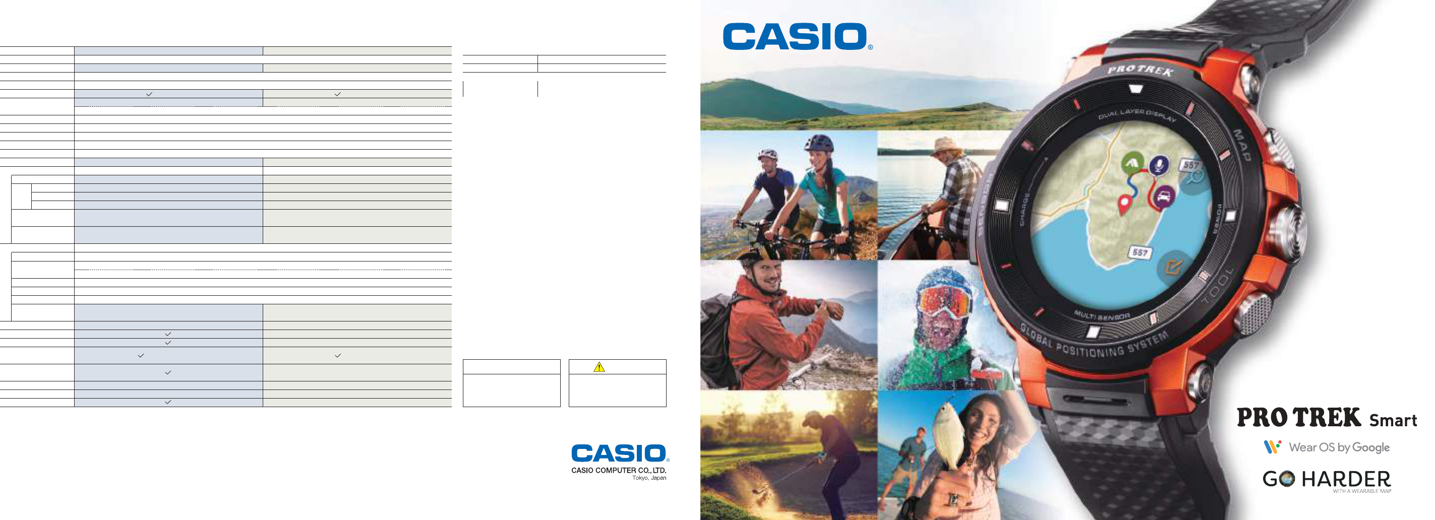
WSD-F30
NEW
The functionality of a smartwatch
combined with the
reliability of outdoor gear.
Activities are changing.
Lifestyles are changing, too.
Experience something new every day with
PRO TREK Smart.
Experience something new.
Outdoor and sports apps
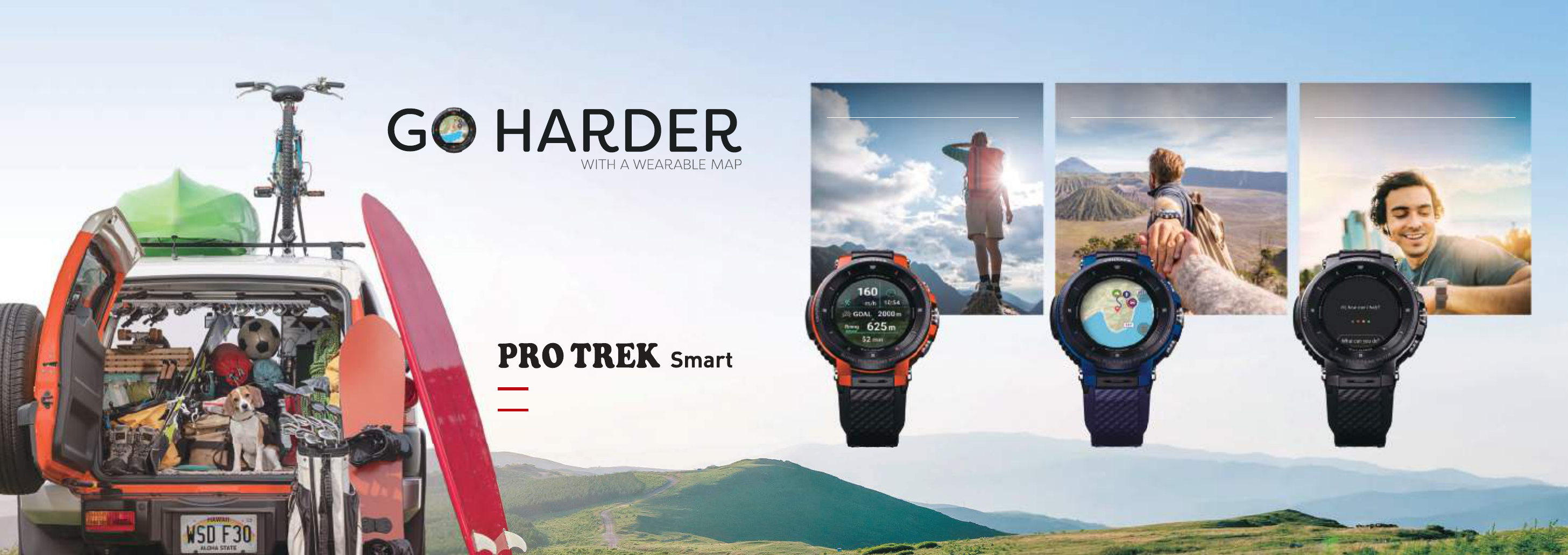
A wearable map on your wrist.
GPS and color map functionality
Take control with your voice.
Wear OS by Google
TM
©Mapbox ©OpenStreetMap
WSD-F30-RG WSD-F30-BU WSD-F30-BK
02PRO TREK Smart01
Daily Style
2 Layers
Adjust power consumption according to how you use the watch with three selectable battery modes.
Military Standard compliance
*1
The watches conform to the MIL-STD-810G standard for durability established by the U.S. Department of Defense.
Casio has confirmed that it operates properly in widely varied environments, meeting users’ toughest outdoor needs.
5-bar water resistance
*2
5-bar water resistance is achieved, even with a microphone installed.
Keep your watch on while enjoying activities such as swimming or fishing.
49.1
mm
53.8
mm
57.7
mm
52.9
mm
WSD-F20 WSD-F30
l
Low temperatures
l l
Water resistance
l
l
Humidity
l
l
Vibrations
l
l
Shocks
l
Frontier
Location
Traveler World time Place
Multi Authentic Journey
Outdoor Style
Original watch faces
Customize according to your preferences.
Dual layer display
[OLED display + monochrome LCD]
For easy readability and low power consumption.
•OLED display
Link with GPS systems or apps to display color
maps and various other information with a high
degree of accuracy.
NEW
NEW NEW
Compact design
For an improved t when worn.
NEW
With operability remaining unchanged, the
watch size has been significantly decreased
due to the miniaturization of parts.
Women and people with slender arms can
wear the watches with a comfortable fit for
long periods of time.
*When recording GPS data (measured at one-minute intervals) and
displaying maps during eight hours of activity per day. (Varies according to use.)
When you want to use all
smartwatch functionality
When you want to keep power
consumption low
For two nights and
three days of activity
Air pressure
display
Bearing
display
Altitude
display
Set your WSD-F30 to the Normal mode
and wear it as a smartwatch, making full
use of its features from color map displays
to notification functions in connection
with your selected apps. Whether
engaging in outdoor adventuring or
normal everyday life, you can enjoy it to
the fullest throughout the day.
*When GPS functionality is not used.
The monochrome face is normally displayed,
but pressing a button calls up the color map.
Optimal management of battery power to
suit your planned activities allows you to
reduce power consumption while still
checking your current location on the map
as necessary, even during a 3-day/2-night
excursion.
*When Wear by Google is turned o.
The battery life might vary depending on sensor usage, etc.
Only the time and sensor data are
displayed when the monochrome LCD
is in use. Selecting this display cuts
power consumption dramatically and
oers security in environments where
charging is not possible. Two display
styles for outdoor or daily life are
selectable.
Normal use
1.5days
*
Life
Battery
Extend mode
3
*
days
Life
Battery
Multi-Timepiece mode
1
*
monthAbout About About
Life
Battery
Monochrome display
GPS function
Color display
Bluetooth®, Wi-Fi
Monochrome display
GPS function
Color display
Bluetooth®, Wi-Fi
•Monochrome LCD
Display the time and sensor readings with low
power consumption. This is convenient when you
want to use the device as a regular watch.
UPDAT ED
•Frontier
Display a graphical map in the background behind the
displayed time, for a colorful representation of the places you
visit. Express the joy of traveling the world.
NEW
•2 Layers
Select one of two styles, a display for the outdoors or one for
everyday use.
UPDAT ED
Monochrome display
GPS function
Color display
Bluetooth®, Wi-Fi
Push
Elapsed time
Altitude display
A monochrome LCD that simultaneously displays both the current time
and sensor readings joins a new, high-contrast OLED display.
Switch between the two types to achieve both low power consumption
and superior readability.
WSD-F30 DESIGN & TECHNOLOGY
©Mapbox ©OpenStreetMap
©Mapbox
©OpenStreetMap
04PRO TREK Smart03
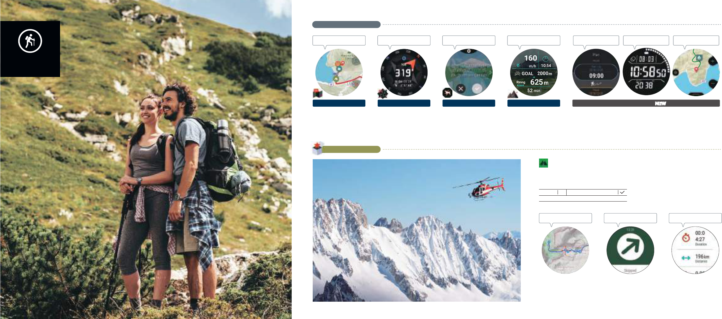
Experience
something new.
Trekking
Check the path you
need to follow.
Display your travel route on the
map based on GPS data.
©Mapbox ©OpenStreetMap
LOCATION MEMORY
Check routes
Check the elevation remaining
towards your goal, as well as your
travel route. Readily display elapsed
time and movement speed.
ACTIVITY:
Trekking
Boost your motivation
Display sensor
readings at all times
Check your
current location
Efficiently conserve
power
Receive automatic notifications
about the remaining elevation
towards your set goal. Set various
conditions.
MOMENT SETTER
Check your goals
Graphically display sensor data.
This is helpful when checking the
direction in which you wish to travel.
TOOL:
Compass
Check direction
This GPS mountain-climbing and trekking app is for lovers of the outdoors the world over, and allows users to check
route guides, maps, navigation, and their progress. Users can plot waypoints to create their own original courses.
(App provided by Augmentra Ltd.)
ViewRanger
Even when beyond the range of
radio signals, your current position is
displayed on the route guides for
various places around the world.
Note: You must download a map in advance.
Display the direction of your
destination, as well as guidance
towards it according to the route
guide.
Display the results of real-time
measurements for distance, time,
elevation, and more.
Usable even when you
can't get a signal
Check the situation
Guidance in the direction
of your destination
ORIGINAL CASIO APPS
Reduce power consumption by managing power according to the activities you have planned. Use the monochrome
LCD display to show your current position and sensor readings at all times. You can even show your current position on
a map in color over a trip lasting two nights and three days during which you don’t have access to battery charging.*
*When recording GPS data and displaying maps during 8 hours activity per day. Varies according to use. ©Mapbox ©OpenStreetMap
FEATURED APPS
For those who want to spend time
how they want to, and for those who
aim for greater heights.
A large collection of apps are your
guide and partner.
Experience something new while
enjoying your favorite activities.
Note: A smartphone is required for initial setup and for some app functionality.
iOS support
Basic cost to use: Free (with paid plans available)
Availability when using only the watch
Extend mode
NEWNEWNEWNEW
06PRO TREK Smart05
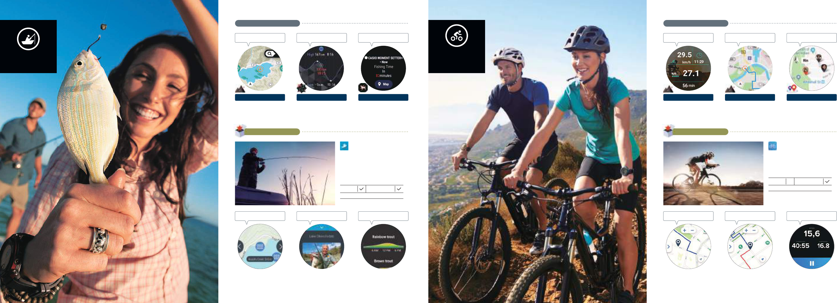
Record places where you caught fish on
the map. This is helpful when you want
to eciently search for fishing spots.
©Mapbox ©OpenStreetMap
ACTIVITY:
Fishing
Record fishing spots
Calculate the period of time
during which fish are more active,
and receive notifications of the
best time to go fishing.
MOMENT SETTER
Don’t miss a time to fish
Estimate fish movements based on
tide data from the specified port.
TOOL:
Tide graph
Check changes
in the tide
Fishing
Don’t miss a time to fish.
Display fishing spots in the surrounding
area on your map.
Estimate your catch based on various
types of fish.
Display photos of fish caught in various
places. Check the types and sizes of
dierent fish.
Display fishing spots Check spcies and sizes
Estimate good
fishing times
Check fishing spots worldwide, and share
photos and data about sizes of fish caught and
the locations where fish were caught with other
fishing enthusiasts. This app boasts the largest
collection of community-based fishing data in
the world. (App provided by Fishbrain AB)
Fishbrain
Record the route you will take on
the map. Check your course for
the day at a glance.
ACTIVITY:
Cycling
Record riding routes
Continuously measure and readily
display ride data, such as speed,
distance, and time.
ACTIVITY:
Cycling
Check ride data
Form a party with your friends to
share messages and your
locations.
CASIO MOMENT LINK
Share data with friends
Cycling
Manage your pace with ease,
whether you’re going solo or
with a group.
Display helpful cycling-related
information on the map, such as
the locations of rest areas and
repair shops.
Search for a cycling route from a collection of over 3.4
million cycling routes covering 80 dierent countries.
Download a map and a route to your watch so that
you can refer to your current location and route even
without connecting your smartphone.
Display ride data, such as speed,
distance, and time.
Display helpful
information
Check your progressDisplay cycling routes
This app contains map data for over 3.4 million
biking routes in 80 countries around the world.
Discover the perfect route, no matter what country
you’re in. (App provided by Bikemap GmbH)
Bikemap
iOS support
Basic cost to use: Free
Availability when
using only the watch
Note: A smartphone is required for initial setup and for some app functionality.
iOS support
Basic cost to use: Free (with paid plans available)
Availability when
using only the watch
ORIGINAL CASIO APPS
FEATURED APPS
ORIGINAL CASIO APPS
FEATURED APPS
08PRO TREK Smart07
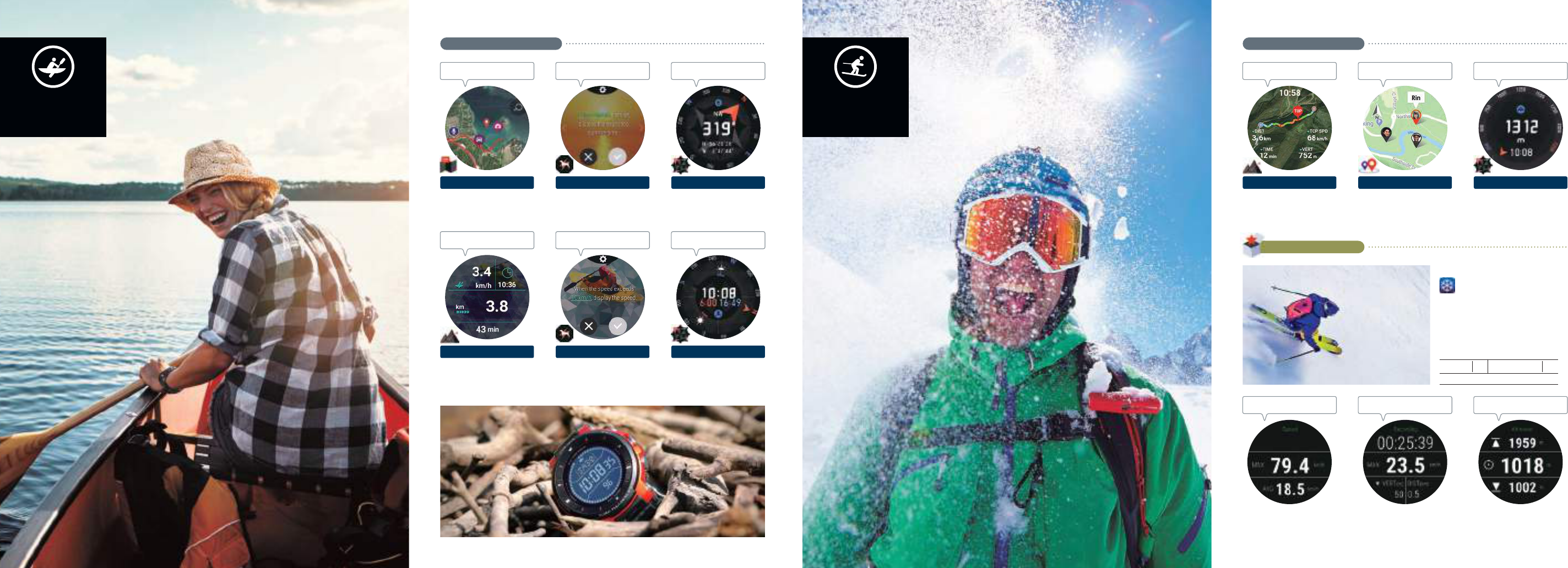
Show scenic sea or lake locations
on the map, as well as your route.
©Mapbox ©OpenStreetMap
LOCATION MEMORY
Check your route
Readily view the status of your
day, including the distance
traveled, the time, and your route.
ACTIVITY:
Paddling
Check your progress
Display your speed when it
exceeds a specified value. Check
your progress in a timely manner.
MOMENT SETTER
Manage your pace
Check the time of the sunset and
the direction in which the sun will
go down, which is helpful for things
such as taking sunset photos.
TOOL:
Sunrise/sunset
Check sunset direction
Check the orientation in which you
should be heading, even in
locations with no clear landmarks.
TOOL:
Compass
Check your direction
of movement
This app notifies you when the time reaches
a specified time until the sunrise. This can
serve as a guide for your departure time.
MOMENT SETTER
Guide for departure times
Display speeds by using dierent
colors. Check the maximum skiing
speeds and the distance.
©Mapbox ©OpenStreetMap
ACTIVITY:
Snow
Record on the map
This app helps you check the
altitude of your current location
when you’re skiing or engaging in
other winter sports.
TOOL:
Altimeter
Check elevation
Form a party with your friends to
share messages and your locations.
CASIO MOMENT LINK
Ski with your friends
Snow
Check skiing conditions
for the day.
Link up with the gliding action to
automatically calculate elapsed
time and distance traveled.
Display your maximum and
average gliding speeds.
Display the elevation at your
present location, as well as
altitude traversed up or down.
Check gliding status
Measure altitude
traveled
Measure speed
Developed with a special focus on winter
sports, Ski Tracks can be used worldwide, and
is indeed used by many people all across the
globe. Users can record their activities on the
ski slope throughout an entire day.
(App provided by Core Corders,.Ltd)
Ski Tracks
Paddle
Record your route,
from departure to return.
iOS support
Basic cost to use: Paid
Availability when
using only the watch
ORIGINAL CASIO APPSORIGINAL CASIO APPS
FEATURED APPS
10PRO TREK Smart09
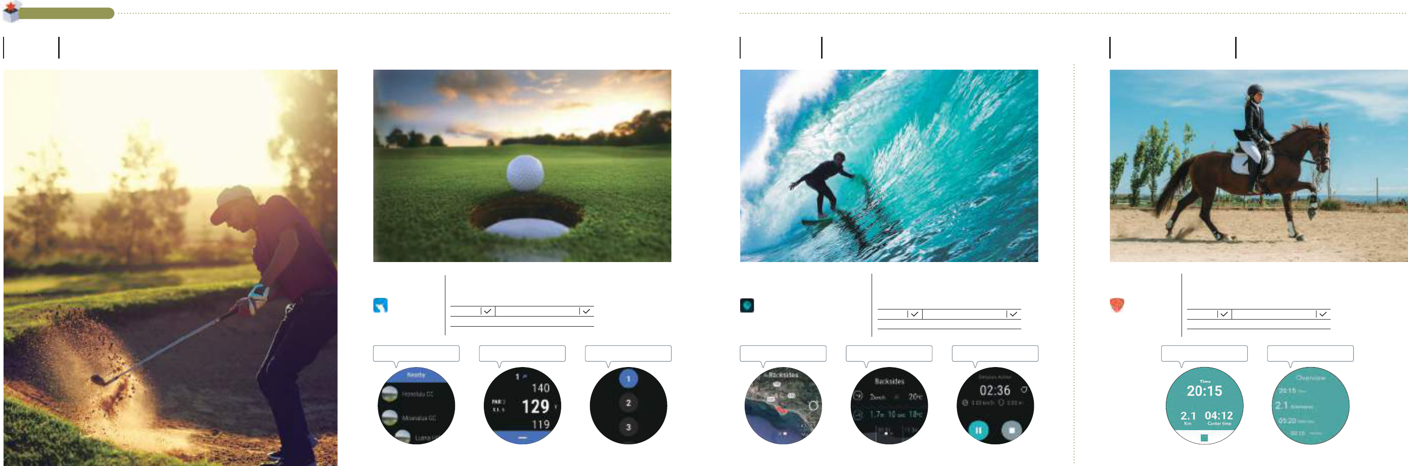
Golf
Check the distance to the green.
Surfing
Don’t miss the perfect wave.
Horse riding
Manage your training and
horse-riding experiences.
Accurately measure the weather
and the surge of waves, with
up-to-the-minute information.
Measure waves
Measure speed and distance, and
evaluate your surfing session.
Measure speed and
distance
Display over 16,000 surfing spots
all across the world.
Search for surfing
locations
Check wave predictions and weather data for 16,000 surfing spots
worldwide. This popular surfing app is used all over the world.
Users can measure and share surfing distance and speed.
(App provided by Gradient Technologies S.L.)
Display time spent training and
riding distance.
Manage horse-riding training
records (walking, trotting,
galloping, distance, and speed)
Measure speed and
time
Manage horse-riding
history
This app can be used to track your training horse-riding training.
Register your horse to have the app analyze its movements and turns, track the length of
its steps, and measure various other data such as step count, speed, and distance.
(App provided by Schvung Ride AB)
Equilab
Use GPS distance measurements
to support accurate graph
selection.
Check remaining
yardage
Automatically display the nearest
course. Smoothly select the
course you plan to play on.
Select course
information
Courses switch automatically within
a round, allowing users to
concentrate on their play. Manually
switching is also supported.
Automatic hole
switching
This global golfing app covers over 42,000 golf courses in 185 world countries.
Use GPS to check your current location on the course and calculate your remaining distance.
(App provided by HOLE19 LTd.)
HOLE19
Golf GPS for
Smartwatch
Glassy Surf Report |
Forecast
Note: A smartphone is required for initial setup and for some app functionality.
iOS support
Basic cost to use: Paid
Availability when using only the watch
Note: A smartphone is required for initial setup and for some app functionality.
iOS support
Basic cost to use: Free (with paid plans available)
Availability when using only the watch
Note: A smartphone is required for initial setup and for some app functionality.
iOS support
Basic cost to use: Free (with paid plans available)
Availability when using only the watch
FEATURED APPS
12PRO TREK Smart11
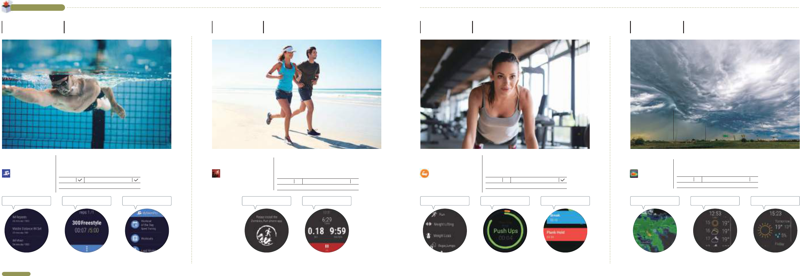
Exercise according to the
on-screen navigation.
Manage your pace
Select from a menu of exercise
created on your smartphone.
Menu selection
Display your progress by using
menus for warmups, rest times,
exercise, and more.
Check your progress
This app helps you with your workout and fitness routines, whether you're
at the gym or at home. Interval training, high-intensity interval training,
and Tabata workouts are just some of the options available from a
customizable menu. (App provided by NeuronDigital)
Exercise Timer
Training menus appropriate to
dierent levels are included.
Menu selection
Manage swimming distance
records by day, week, or month.
Manage records
Display records by selecting stroke
and distance.
Measure records
Record and analyze a variety of log data while swimming, including number of
strokes, lap times, and distances.
This app manages your training just like a coach that you can wear on your wrist.
(App provided by MySwimPro)
MySwimPro
Display your speed, distance, and
time while walking or running in
real time.
Check your pace
Engage in interval training while
following a story.
Raise motivation
This app provides a new and unique running experience as you listen to a
story unfold from voice recordings. Run to escape attacking zombies!
Gain items when you’re finished, and gradually increase locations where
you’re safe from the zombies. (App provided by Six to Start)
Zombies, Run!
Display animated weather maps.
Check whether rain is headed in
your direction or moving away
from you, and at what speed.
Display changes in the weather
and temperature at one-hour
intervals.
Check the day’s weather
Display the weather, temperature,
and chance of rain for tomorrow
and later days.
Check the weather for
tomorrow and later days
Check amount of rain
This helpful weather information app predicts the weather by displaying an animated
depiction of weather changes in the surrounding area.
(App provided by ACME AtronOmatic)
MyRadar
FEATURED APPS
FEATURED APPS
Exercise
For ecient workouts.
Weather
Predict sudden weather changes.
Running
Have more fun running.
Swimming
Record and analyze your swimming.
Note: A smartphone is required for initial setup and for some app functionality.
iOS support
Basic cost to use: Free (with paid plans available)
Availability when using only the watch
Note: A smartphone is required for initial setup and for some app functionality.
iOS support
Basic cost to use: Free (with paid plans available)
Availability when using only the watch
iOS support
Basic cost to use: Free
Availability when using only the watch
iOS support
Basic cost to use: Free (with paid plans available)
Availability when using only the watch
For details about these apps, contact the app providers. Watches are not guaranteed against damage or accidents when apps are in use. The use of some apps might require separate voice call or data charges or include paid content. Apps are subject to discontinuation or change without notice. Additional installation from "Featured apps" in the app menu is required. Some apps might not support connections with iOS devices. The information herein is based on information received from app providers as of December 2018.
14PRO TREK Smart13
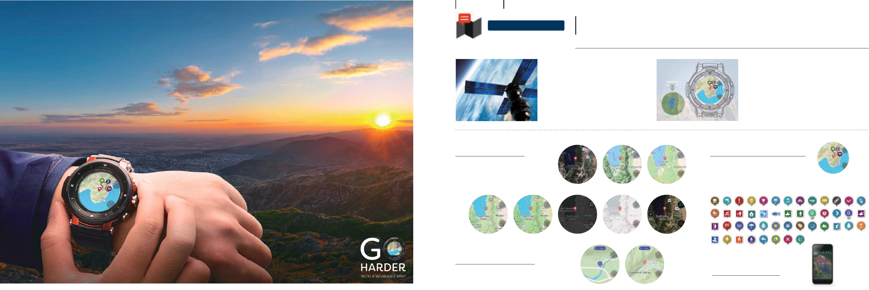
The watch is capable of receiving stable position data due to its
support of three satellite positioning systems: the United States
GPS system, Russia's GLONASS, and Japan's Michibiki.
Because the watch includes GPS functionality, you can calculate
your current location even without a smartphone.
Find your location
using only your watch
[GPS equipped]
Display your current location on the map,
even when you’re not getting a signal
[Oine map support]
Five apps for
outdoor activities
Original Casio apps
LOCATION MEMORY
Light Satelite
Mapbox
Street Outdoors Dark
Google
Maps
TM
Satelite Terrain Map
Display your current location on the map.
Color map display
Check your current location.
Point Navigation
NEW
Use a simple navigation system.
Creation of original maps
Record information on maps.
Save activity data
Check routes.
An original app that links with GPS and color map functions.
Press the MAP button to start it up immediately, and use the app in a wide variety of outdoor scenarios.
Functions available for use in this app when connected through iOS are restricted.
Download
maps in advance
Destination Distance and direction
Supports the United States GPS system, Russia’s GLONASS, and Japan’s Michibiki. Map data from Google Maps™ and Mapbox is used.
A wearable map on your wrist.
Now including GPS functionality that supports three satellite
positioning systems, as well as color map functions.
Determine your current location with a high degree of accuracy,
and display a high-definition map.
Check your current location on the map even when you can't
receive a cellular signal, and further expand the range of your
outdoor activities.
©Mapbox
©OpenStreetMap
Readily check a color map for your present location,
at any time.
You can change the type or design of maps, and how often
GPS signals are acquired (1 minute, 6 minutes, or o).
Specify your destination, and display the distance from your current
location and the direction on the map.
You can use this for simple navigation. View from Google Earth™ on your smartphone or PC.
Display your activity routes on the map.
Create your own original maps by recording memos and markers.
•Voice memos:
Automatically convert words spoken into the microphone into text, and record this text on the map.
•Markers:
Document your trip by leaving various markers.
UPDAT E D
Whether you’re out in the field where your smartphone is not receiving a signal,
or whether you’re engaged in activities such as water sports where
smartphones are inconvenient to use, by downloading the map for your
destination in advance, you can check your current position on the map.
•You can download up to five maps of world locations.
UPDAT E D
16PRO TREK Smart15
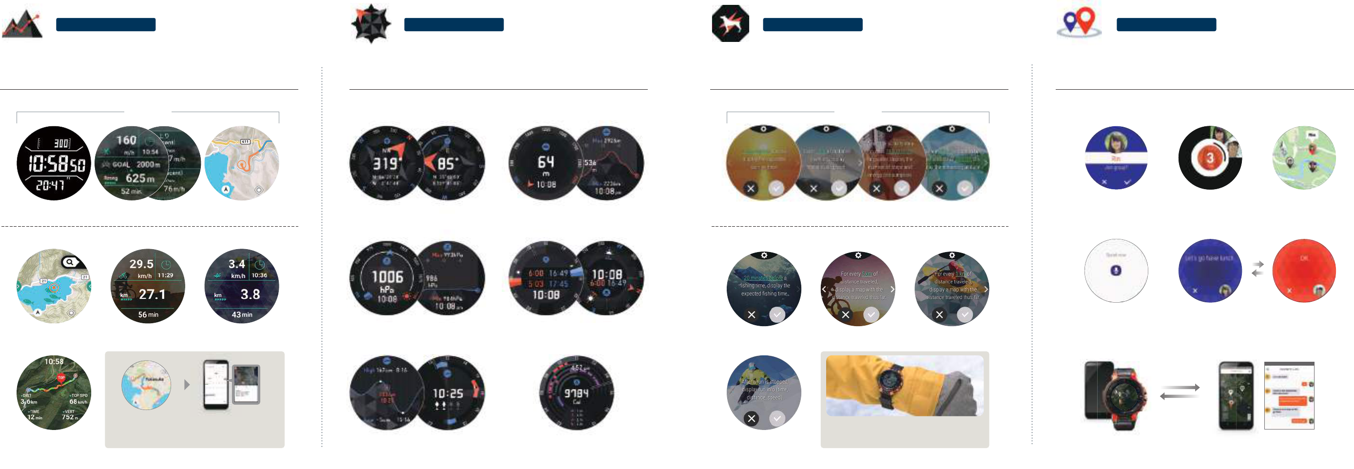
ACTIVITY
Display a wealth of information in real time, from your map and your travel route to data such as
speed, distance, altitude, and air pressure changes.
Use this information to help you quickly ascertain your status and take the right actions. Even the
monochrome LCD screen displays some of the data from sensor readings.
MOMENT SETTER
Set up conditions in advance to receive notifications about the information you need while your activities are being tracked.
This information not only helps you make sure not to miss the best times for events like the sunrise, but also helps you
manage your pace and increase your motivation.
•Notifications upon reaching or departing from a destination point are not available when connected to an iOS device.
•Functions available for use in this app when connected through iOS are restricted.
TOOL CASIO MOMENT LINK
Use simple operations to form parties on the spot, without the need for anyone to register an account.
Check the location of your members on the map, and send messages to each other to share the enjoyment of your activity.
•This app cannot be used when the watch is connected to an iOS device, but the app can be used from an iOS device by itself.
•This app uses your smartphone's cellular network or GPS. The app cannot be used in locations where your smartphone does not receive a signal or in locations where GPS
data cannot be acquired.
Save measurement data and have it backed up automatically to Google Drive™.
You can also view information from other Google services, such as
Google Calendar™ and Google Earth™, from your smartphone or PC.
These services require an update to the latest version of the Casio app.
Vibration to notify you of information
Notifications are indicated by using vibration, which gets you the
message even when you’re busy with outdoor sports.
Check member status on the map
Group up even with others who
don’t have a PRO TREK Smart.
Speak into the microphone to send messages by using voice-to-text conversion.
Save yourself the trouble of getting out your smartphone by sending and reading messages on the watch screen.
Use simple operations to form parties of up to nine people on the spot. No account registration required.
Display the locations of your members on the map to keep track of where everyone is while you’re on the move.
You can even form parties with those who do not have Pro Trek Smart devices, as well as share your current location and send messages to them.
Note: This app can be used with Android and iOS devices that have GPS functionality.
Measurement screenMonochrome display
Trekking
Map screen
©Mapbox ©OpenStreetMap
Distance traveled
notifications
Scheduled time
notifications
Progress
notifications
Activity level
notifications
Cycling
Current time/speed/ride distance
Paddle
Current time/speed/ride distance
Fishing
Current time/air pressure/catch
©Mapbox ©OpenStreetMap
Snow
Current time/ride distance/top speed
©Mapbox ©OpenStreetMap
Compass
Direction/GPS latitude and longitude/bearing memory
Barometer
Atmospheric pressure/atmospheric pressure graph
Sunrise/sunset
Sunrise & sunset ttime/sunrise & sunset direction
Tide and Fishing
Tide graph/fishing time
My Graph
Activity time/calorie consumption/
step count/exercise time/cumulative altitude
Altimeter
Altitude/altitude graph
Fishing Cycling Paddle
Snow
Trekking
Display the Notication content that are required for your various activities.Display the measurements that are required for your various activities.
NEW
Send messages
Supports backups of measurement data
Start simply by pressing the TOOL button, and display changes in natural phenomena and other
information you need for your outdoor activities.
Switch to the monochrome display with the touch of a button. This display is easy to read even in
bright sunlight. You can also manually correct readings for elevation and air pressure.
18PRO TREK Smart17
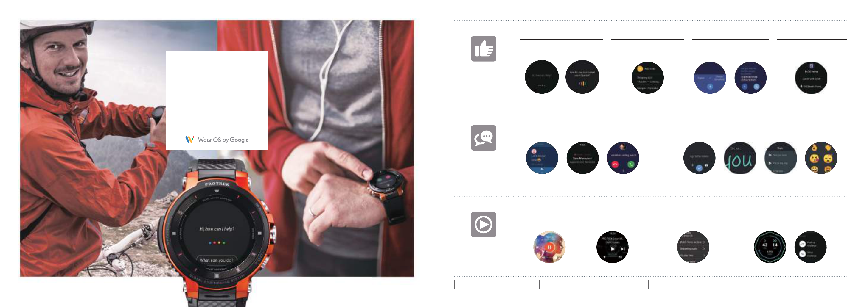
Google Assistant
Support at your fingertips for
whatever you want to learn about!
*Note that voice communications are not possible when using only the watch.
Keep Gmail™ always close at hand!
Google Translate™
Feel at ease when visiting other countries,
with voice translation functionality!
Google Keep™
Something bugging you?
Then make a voice memo!
Calendar notifications
Check your schedule with
reminder notifications!
Google Play Music™ Media controls
Control your music from your wrist!
Google Fit™
Manage your physical condition by
recording how much you exercise!
Google Play™ store
Search for the apps that you like!
See this link for the latest information regarding
Wear OS by Google support.
https://support.google.com/wearos/
Some apps might not support connections with iOS devices. Some functions available for use when connected through iOS are restricted. Some apps require a separate installation.
Take control
with your voice.
Voice input
Simple exchange of messages!
On or o.
Support for smart
daily living.
Support
Whenever, wherever.
Connect with everyone.
Communication
Make every day more fun,
and more for you.
Enjoy
Manual entry Templates Emoji
Various smartwatch functions are
made even more convenient with
Wear OS by Google.
Use the Google Assistant™ or
other functions to start your smart
life, whether it is outdoors or
throughout daily living.
Start the app by saying the words “OK Google” into the
microphone. Receive responses right away about the
things you want to know.
Receive direct notifications of incoming calls, email, and messages.
Check your communications easily, even in places where it's hard to get out your smartphone.
Directly reply to text messages by simply speaking into the
microphone on the watch.
Convert spoken words to text just by speaking into
the microphone. It's easy to take memos or create
to-do lists.
Translate spoken words into the specified language.
This is helpful on business trips or vacations.
Download music to your watch, and play
it back without using your smartphone.
Find the things you want, from popular watch faces to
apps to improve your work eciency.
Record data on your activities, such as step count or calories burned,
and check your progress towards your goals.
Conveniently control music and
video apps.
Receive direct notifications of upcoming events
you have scheduled in Google Calendar.
SMS
notifications
Gmail
notifications
Incoming call
notifications*
20PRO TREK Smart19
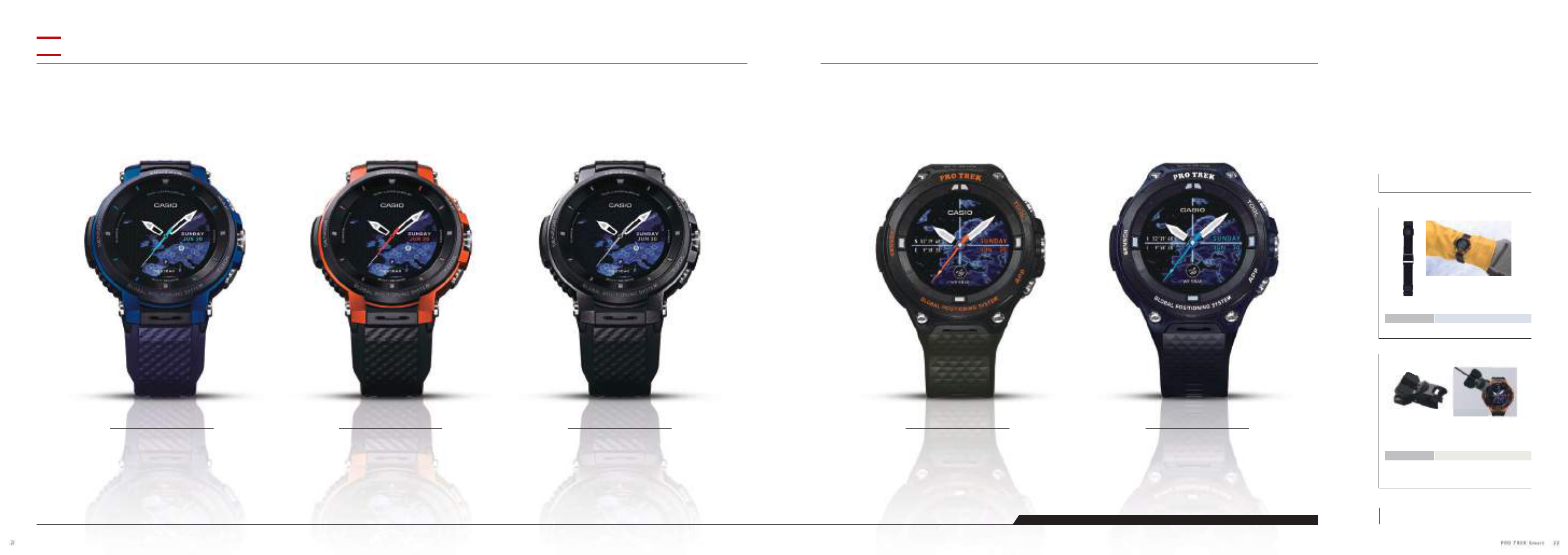
Included accessories
• AC adaptor • Special charger cable
WSD-F30-BU
Included accessories
• AC adaptor • Special charger cable
WSD-F30-RG
Included accessories
• AC adaptor • Special charger cable
WSD-F30-BK
Included accessories
• AC adaptor • Special charger cable
WSD-F20A-GN
Included accessories
• AC adaptor • Special charger cable
WSD-F20A-BU
WSD-F20A
Outdoor gear to simulate the adventurer’s spirit.
Intuitive touch controls on a large LCD interface.
WSD-F30
A compact size that does not obstruct movement, with superior readability and low power consumption.
Expand the range of your activities, from the outdoors to daily living.
NEW
Some specications differ between the WSD-F30 and the WSD-F20A. For details, see the back cover.
Supported models WSD-F20 / WSD-F20A
Charging holder
WSA-H1
Depiction of accessory attached
Accessories
Supported models WSD-F30
Removable cloth band
WSA-BX1
Depiction of accessory attached
•WSA-H1 does not come with the WSD-F20 / WSD-F20A or a charging cable.
•This accessory is not compatible with the WSD-F30.
A charging holder for the WSD-F30 is planned for a spring 2019 release.
•This accessory cannot be used with the WSD-F20, WSD-F20X, or WSD-F20A.
The latest information on accessories is available here:
https://wsd.casio.com/option/
22PRO TREK Smart21
