!
!
!
!
!
!
!
!
!
!
!
!
!
!
!
!
!
!
!
!
!
!
!
!
!
!
!
!
!
!
!
!
!
!
!
!
!
!
!
!
!
!
!
!
!
!
!
!
!
!
!
!
!
!
!
!
!
!
!
!
!
!
!
!
!
!
!
!
!
!
!
!
!
!
!
!
!
!
!
!
!
!
!
!
!
!
!
!
!
!
!
!
!
!
!
!
!
!
!
!
!
!
!
!
!
!
!
!
!
!
!
!
!
!
!
!
!
!
!
!
!
!
!
!
!
!
!
!
!
!
!
!
!
!
!
!
!
!
!
!
!
!
!
!
!
!
!
!
!
!
!
!
!
!
!
!
")
")
")
")
")
")
")
")
")
")
")
")
")
")
")
")
1
6
8
3
5
2
9
4
11
12
13
14
15
16
10
7
/
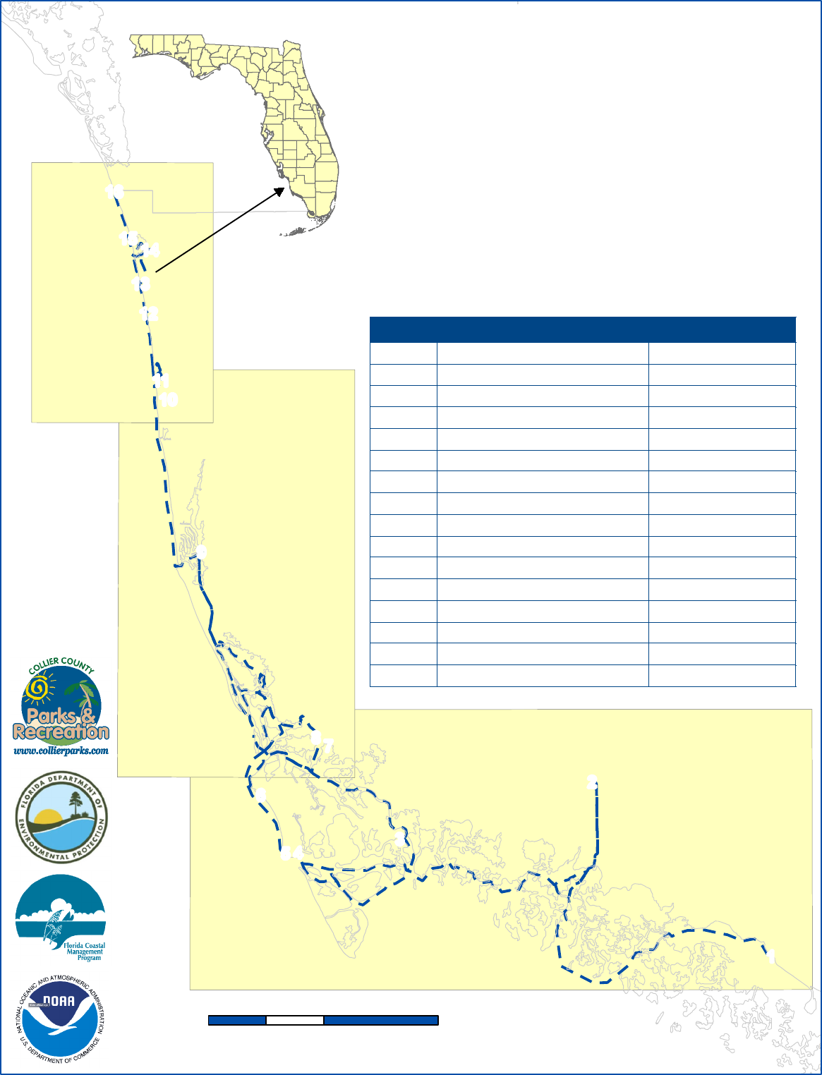
Paradise Coast Blueway
Saltwater Paddling Trails
Collier County
0 5 102.5
Miles
Boat Ramps and Beach Access
Segment Waypoint Location Latitude, Longitude
1
1 Gulf Coast Ranger Station 25.845752, -81.387034
2 Port of Islands Boat Ramp 25.956767, -81.511656
3 Goodland Boat Park 25.920917, -81.646014
4 Caxambas Park Boat Ramp 25.912595, -81.717079
5 South Marco Island Beach Access 25.912220, -81.725645
6 Tigertail Beach Park 25.948933, -81.743036
2
7 Collier Blvd - 951 Boat Ramp 25.980431, -81.703328
8 Isles of Capri Paddlecraft Park 25.985260, -81.704247
9 Bayview Park Boat Ramp 26.102725, -81.784308
3
10 North Gulfshore Beach Access 26.207262, -81.814671
11 Clam Pass Beach Park 26.211011, -81.812562
12 Vanderbilt Beach Access 26.253437, -81.821143
13 Bluebill Beach Access 26.272278, -81.826606
14 Cocohatchee River Park Boat Ramp 26.293582, -81.820067
15 Barefoot Beach Preserve Park 26.300850, -81.833080
16 Barefoot Beach Access 26.330324, -81.844990
!
!
!
!
!
!
!
!
!
!
!
!
!
!
!
!
!
!
!
!
!
!
!
!
!
!
!
!
!
!
!
!
!
!
!
!
!
!
!
!
!
!
!
!
!
!
!
!
!
!
!
!
!
!
!
!
!
!
!
!
!
!
!
!
!
!
!
!
!
!
!
!
!
!
!
!
!
!
!
!
!
!
!
!
!
!
!
!
!
!
!
!
!
!
!
!
!
!
!
!
!
!
!
!
!
!
!
!
!
!
!
!
!
!
!
!
!
!
!
!
!
!
!
!
!
!
!
!
!
!
!
!
!
!
!
!
!
!
!
!
!
!
!
!
!
!
!
!
!
!
!
!
!
!
!
!
!
!
!
!
!
!
!
!
!
"
)
"
)
"
)
"
)
"
)
"
)
"
)
"
)
"
)
"
)
"
)
"
)
"
)
"
)
"
)
"
)
1
6
8
3
5
2
9
11
12
13
15
16
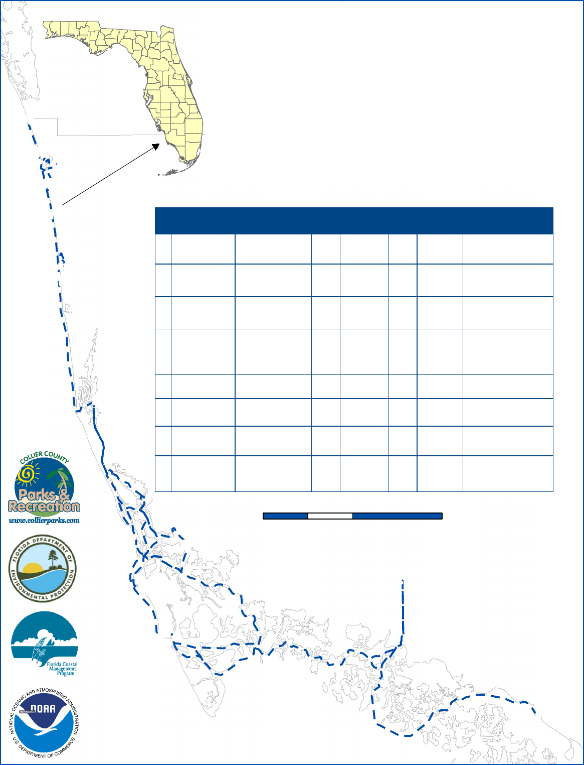
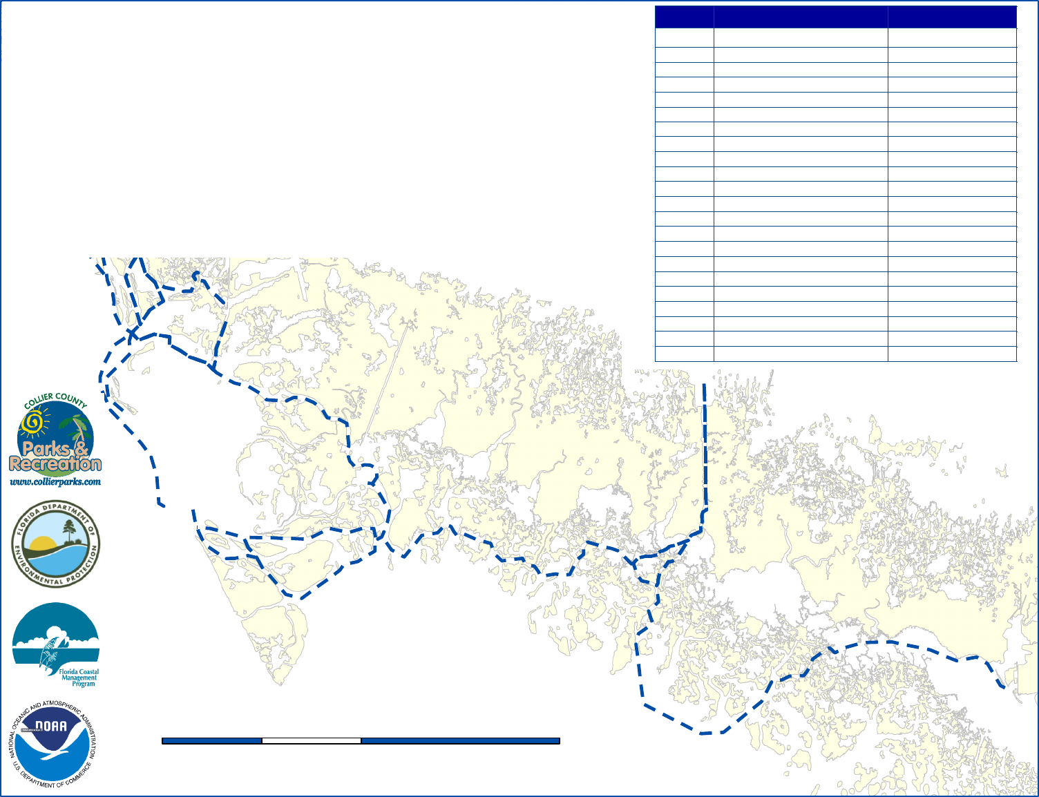
Paradise Coast Blueway
Saltwater Paddling Trails
Collier County
Boat Ramp & Park Amenities
Everglades City - Cocohatchee Boat Ramp
/
0 5 102.5
Miles
^
^
^
^
^
^
^
^
^^
^
^
^
^
^
^
^
^
^
^
4
14
10
7
ID Name Address Amenities
1 30 3 5
2 22 2 71
3 13 3 73 2
4 84 4 54 1
7 10 72 2
8 51 6 5
9 Bayview Boat Park 12 2 55 2
14 14 4 54 2
Car
Parking
Handicapped
Car Parking
Boat
Trailer
Parking
Handicapped
Boat Trailer
Parking
Gulf Coast Ranger
Station
815 Oyster Bar Lane
Everglades City, FL
34139
Marina, Boat/Kayak Tours,
Picnic Area, Receptacles,
Restrooms
Port of the Islands
Marina
525 Newport Drive
Naples, FL 34114
Ship Store, Fuel, Fish
Cleaning Table, Picnic Area,
Restrooms
Goodland Boat
Park
750 Palm Point
Marco Island, FL 34145
Ship Store, Fishing Pier,
Fish Cleaning Table, Picnic
Area, Restrooms
Caxambas Park
Boat Ramp
909 Collier Court
Marco Island, FL 34145
Ship Store, Fuel, Fishing
Pier, Fish Cleaning Table,
Picnic Area,
Restrooms, Pump-out
Station
Collier Boat Ramp
aka 951 Boat Ramp
3620 Collier Blvd
Naples, FL 34114
Fish Cleaning Table, Port-o-
let
Isles of Capri
Paddlecraft Park
1295 Capri Blvd
Naples, FL 34114
Picnic Area, Restrooms,
Non-Motorized Launch
1500 Danford Street
Naples, FL 34112
Fishing Pier, Fish Cleaning
Table, Picnic Area,
Restrooms, Playground
Cocohatchee River
Park Boat Ramp
13531 Vanderbilt Drive
Naples, FL 34110
Ship Store, Fuel, Fish
Cleaning Table, Picnic Area,
Restrooms, Pump-out
Station, Playground
!
!
!
!
!
!
!
!
!
!
!
!
!
!
!
!
!
!
!
!
!
!
!
!
!
!
!
!
!
!
!
!
!
!
!
!
!
!
!
!
!
!
!
!
!
!
!
!
!
!
!
!
!
!
!
!
!
!
!
!
!
!
!
!
!
!
!
!
!
!
!
!
!
!
!
!
!
!
!
!
!
!
!
!
!
!
!
!
!
!
!
!
!
!
!
!
!
!
!
!
!
!
!
!
!
!
!
!
!
!
!
!
!
!
!
!
!
!
!
!
!
!
!
!
!
!
!
!
!
!
!
!
!
!
!
!
!
!
!
!
!
!
!
!
!
!
!
!
!
!
!
!
!
!
!
!
!
!
!
!
!
!
!
!
!
"
)
"
)
"
)
"
)
"
)
"
)
"
)
"
)
"
)
"
)
"
)
"
)
"
)
"
)
"
)
"
)
1
6
8
3
5
2
9
11
12
13
15
16
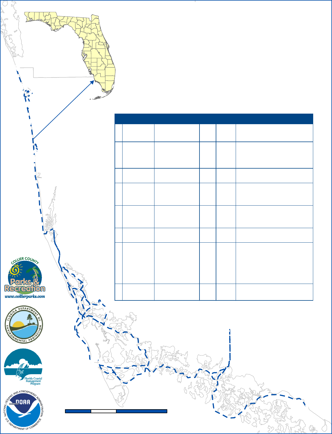
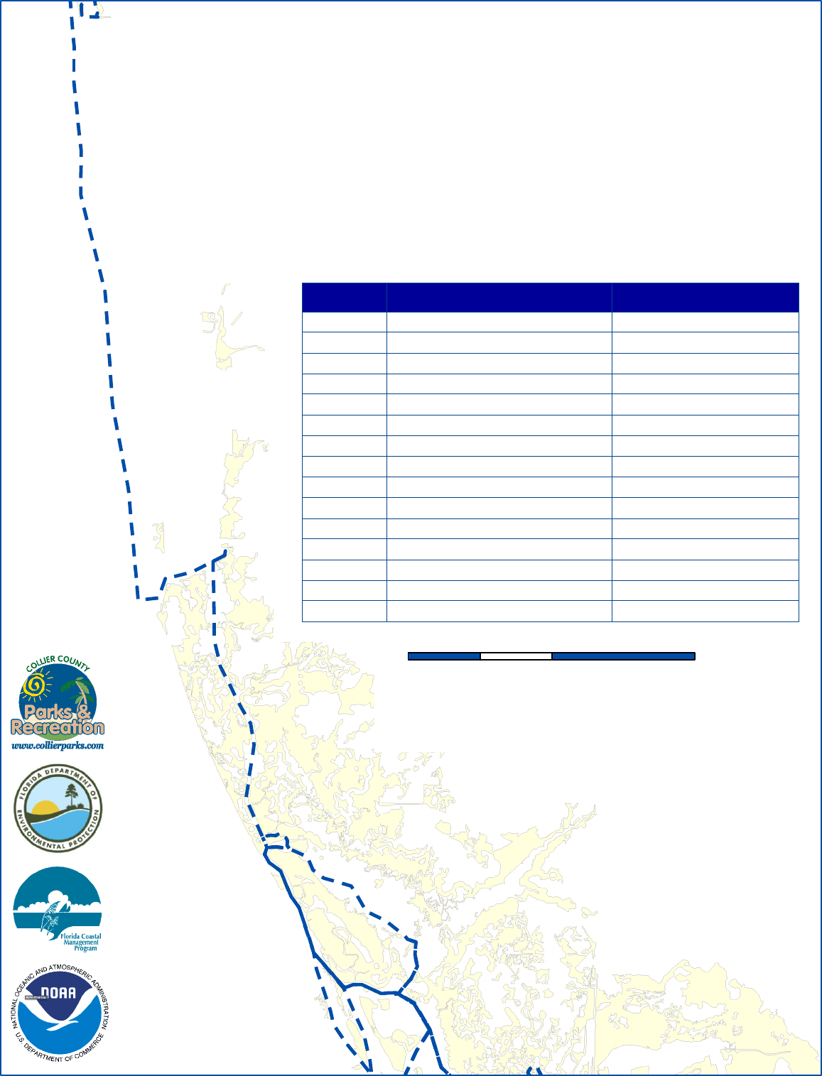
Paradise Coast Blueway
Saltwater Paddling Trails
Collier County
Beach Access Amenities
Marco Island South - Barefoot Beach
/
0 5 102.5
Miles
^
^
^
^
^
^
^
^
^^
^
^
^
^
^
^
^
^
^
^
4
14
10
7
ID Name Address Parking Amenities
5 64 3
6 226 6
10 36 2
11 191 7
12 343 12
13 N/A N/A
15 229 13
16 90 6
Handicap
Parking
Marco Island
South Beach
Access
930 South Collier Blvd
Marco Island, FL 34145
Restrooms, Solar Parking Meter, Foot
Showers, Trash Receptacles
Tigertail Beach
Park
480 Hernando Drive
Marco Island, FL 34145
Restrooms, Children's Playground,
Restaurant, BBQ Grills, Picnic Area, Beach
Rentals, Booth Attendant, Solar Parking
Meter, Park Rangers, Trash Receptacles,
Boardwalks, Dune Crossovers
North Gulf Shore
Beach Access
North Gulf Shore Blvd
Naples, FL 34102
Solar Parking Meter, Bike Rack, Showers,
Trash Receptacles
Clam Pass Beach
Park
465 Seagate Drive
Naples, FL 34103
Solar Parking Meter, Booth Attendant,
Tram Ride to Beach, Bike Rack,
Beach Concession, Trash Receptacles,
Restrooms
Vanderbilt Beach
Park
100 Vanderbilt Beach Rd
Naples, FL 34108
Booth Attendant, Parking Garage,
Restrooms, Foot Showers,
Beach Concession, Trash Receptacles,
Solar Parking Meter, Bike Racks
Bluebill Beach
Access
11129 Park Drive
Naples, FL 34108
No Parking/Drop Off Only, Restrooms,
Foot Showers, Bike Rack
Barefoot Beach
Preserve Park
505 Barefoot Beach Blvd
Bonita Springs, FL
34134
Booth Attendant, Picnic Area,
Beach Concession (Chairs, Cabanas),
Restrooms, Beach Wheelchair, Nature Trail,
Environmental Learning Center, Butterfly
Garden, Cactus Garden, Park Rangers,
Vending Machine,
Trash Receptacles, Foot Showers,
Boardwalk and Dune Crossovers,
Bike Rack
Barefoot Beach
Access
5901 Bonita Beach Road
Bonita Springs, FL 34134
Solar Parking Meter, Trash Receptacles,
Picnic Pavilions, Restroom Facilities, Bike
Rack
!
!
!
!
!
!
!
!
!
!
!
!
!
!
!
!
!
!
!
!
!
!
!
!
!
!
!
!
!
!
!
!
!
!
!
!
!
!
!
!
!
!
!
!
!
!
!
!
!
!
!
!
!
!
!
!
!
!
!
!
!
!
!
!
!
!
!
!
!
!
!
!
!
!
!
!
!
!
!
!
!
!
!
!
!
!
!
!
!
!
!
!
!
!
!
!
!
!
!
!
!
!
!
!
!
!
!
!
!
!
!
!
!
!
!
!
!
!
!
!
!
!
!
!
!
!
!
!
!
!
!
!
!
!
!
!
!
!
!
!
!
!
!
!
!
!
!
!
!
!
!
!
!
!
!
!
!
!
!
!
!
!
!
!
!
!
!
!
!
!
!
!
!
!
!
!
!
!
!
!
!
!
!
"
)
"
)
"
)
"
)
"
)
"
)
"
)
"
)
"
)
"
)
"
)
"
)
"
)
"
)
"
)
"
)
"
)
"
)
"
)
"
)
1
5
7
9
8
4
6
3
2
10
12
11
13
14
15
16
18
17
19
20
Paradise Coast Blueway
Saltwater Paddling Trails
Collier County
GPS Trail Names
/
0 5 102.5
Miles
Trail Name Miles
1 Everglades City - Port of the Islands 20.0
2 Faka Union Bay Loop 4.0
3 Port of the Islands - Goodland 16.0
4 Caxambas Park - Helen Key Loop 8.5
5 Caxambas Bay Loop 4.3
6 Goodland Ramp - Bayview Boat Park 19.2
7 Marco Island South Beach - Tigertail Beach Park 8.0
8 951 Boat Ramp - Rookery Bay 9.3
9 Collier Blvd Bridge - Little Marco Island Loop 9.0
10 Isles of Capri Park - Johnson Bay Loop 7.0
11 Isles of Capri Park - Rookery Bay Reserve 11.0
12 Bayview Boat Park - Rookery Bay Reserve Loop 5.2
13 Bayview Ramp - Gordon Pass - Clam Pass Park 10.5
14 Clam Pass Beach Park - Outer Clam Bay - Beach Access 1.7
15 Clam Pass - Vanderbilt Beach 2.5
16 Vanderbilt Beach - Bluebill Beach 1.6
17
Bluebill Beach - Cocohatchee Park Boat Ramp
2.3
18 Delnor-Wiggins Pass State Park 1.0
19
Barefoot Beach Preserve Park - Wiggins Bay Loop
2.2
20
Cocohatchee Park Boat Ramp - Barefoot Beach
4.0
!
!
!
!
!
!
!
!
!
!
!
!
!
!
!
!
!
!
!
!
!
!
!
!
!
!
!
!
!
!
!
!
!
!
!
!
!
!
!
!
!
!
!
!
!
!
!
!
!
!
!
!
!
!
!
!
!
!
!
!
!
!
!
!
!
!
!
!
!
!
!
!
!
!
!
!
!
!
!
!
!
!
!
!
!
!
!
!
!
!
!
!
!
!
!
!
!
!
!
!
!
!
!
!
!
!
!
!
!
!
!
!
!
!
!
!
!
!
!
!
!
!
!
!
!
!
!
!
!
!
!
!
!
!
!
!
!
!
!
!
!
!
!
!
!
!
!
!
!
!
!
!
")
")
")
")
")
")
")
")
")
")
")
")
")
")
")
")
Segment 1
Segment 3
Segment 2
1
6
8
3
5
2
9
4
11
12
13
14
15
16
Paradise Coast Blueway
Saltwater Paddling Trails
Collier County
Everglades City - Barefoot Beach
/
0 5 102.5
Miles
"
)
"
)
"
)
"
)
"
)
"
)
"
)
"
)
"
)
"
)
"
)
"
)
"
)
"
)
"
)
"
)
LEE
COLLIER
10
7
Waypoint Location Latitude, Longitude
1 Gulf Coast Ranger Station 25.845752, -81.387034
2 Port of Islands Boat Ramp 25.956767, -81.511656
3 Goodland Boat Park 25.920917, -81.646014
4 Caxambas Park Boat Ramp 25.912595, -81.717079
5 South Marco Island Beach Access 25.912220, -81.725645
6 Tigertail Beach Park 25.948933, -81.743036
7 Collier Blvd - 951 Boat Ramp 25.980431, -81.703328
8 Isles of Capri Paddlecraft Park 25.985260, -81.704247
9 Bayview Park Boat Ramp 26.102725, -81.784308
10 North Gulfshore Beach Access 26.207262, -81.814671
11 Clam Pass Beach Park 26.211011, -81.812562
12 Vanderbilt Beach Access 26.253437, -81.821143
13 Bluebill Beach Access 26.272278, -81.826606
14 Cocohatchee River Park Boat Ramp 26.293582, -81.820067
15 Barefoot Beach Preserve Park 26.300850, -81.833080
16 Barefoot Beach Access 26.330324, -81.844990
!
!
!
!
!
!
!
!
!
!
!
!
!
!
!
!
!
!
!
!
!
!
!
!
!
!
!
!
!
!
!
!
!
!
!
!
!
!
!
!
!
!
!
!
!
!
!
!
!
!
!
!
!
!
!
!
!
!
!
!
!
!
!
!
!
!
!
!
!
!
!
!
!
!
!
!
!
!
!
!
!
!
!
!
!
!
!
!
!
!
!
!
!
!
!
!
!
!
!
!
!
!
!
!
!
!
!
!
!
!
!
!
!
!
!
!
!
!
!
!
!
!
!
!
!
!
!
!
!
!
!
!
!
!
!
!
!
!
!
!
!
!
!
!
!
!
!
!
!
!
!
!
!
!
!
!
!
!
!
!
!
!
!
!
!
!
!
!
!
!
!
!
!
!
!
!
!
!
!
!
!
!
!
!
!
!
!
!
!
!
!
!
!
!
!
!
!
!
!
!
!
!
!
!
!
!
!
!
!
!
!
!
!
!
!
!
!
!
!
!
!
!
!
!
!
!
!
!
!
!
!
!
!
!
!
!
!
!
!
!
!
!
!
!
!
!
!
!
")
")
")
")
")
")
")
")
")
")
")
")
")
")
")
")
")
")
")
")
")
")
")
")
")
")
")
")
")
")
")
7
6
5
4
3
2
1
8
9
10
11
14
13
12
15
17
18
27
26
23
21
20
19
24
25
28
22
16
0
5 102.5
Miles
Paradise Coast Blueway
Saltwater Paddling Trails
Collier County
Everglades City
to
Big Marco Pass
/
Waypoint Name Latitude, Longitude
1 Everglades City 25.845785, -81.387013
2 Lane Cove 25.859897, -81.423218
3 West Pass Bay 25.860124, -81.452360
4 Gaskin Bay 25.844896, -81.484315
5 West Pass 25.828861, -81.507754
6 Fakahatchee Pass 25.839455, -81.534650
7 Panther Key 25.861178, -81.537460
8 Port of the Islands 25.956767, -81.511656
9 Faka Union Canal 25.921562, -81.509075
10 Faka Union Bay 25.899356, -81.516248
11 Faka Union Bay Loop 25.882870, -81.529241
12 Santina Bay 25.896442, -81.546830
13 Fish Hawk Creek 25.890182, -81.578573
14 Shell Key Bay 25.900870, -81.603964
15 Snook Hole Channel - Blind Pass 25.880122, -81.679283
16 Caxambas Pass 25.906849, -81.715911
17 Coon Key Pass 25.910677, -81.637195
18 Big Marco River 25.942719, -81.654399
19 Collier Blvd Bridge 25.964753, -81.710851
20 McIlvance Bay 25.987845, -81.705194
21 Johnson Bay 25.994535, -81.731929
22 Big Marco Pass 25.976038, -81.741456
Segment 1
!
!
!
!
!
!
!
!
!
!
!
!
!
!
!
!
!
!
!
!
!
!
!
!
!
!
!
!
!
!
!
!
!
!
!
!
!
!
!
!
!
!
!
!
!
!
!
!
!
!
!
!
!
!
!
!
!
!
!
!
!
!
!
!
!
!
!
!
!
!
!
!
!
!
!
!
!
!
!
!
!
!
!
!
!
!
!
!
!
!
!
!
!
!
!
!
!
!
!
!
!
!
!
!
!
!
!
!
!
!
!
!
!
!
!
!
!
!
!
!
!
!
!
!
!
!
!
!
!
!
!
!
!
!
!
!
!
!
!
!
!
!
!
!
!
!
!
!
!
!
!
!
!
!
!
!
!
!
!
!
!
!
!
!
!
!
!
!
!
!
!
!
!
!
!
!
!
!
!
!
!
!
!
!
!
!
!
!
!
!
!
!
!
!
!
!
!
!
!
!
!
!
!
!
!
!
!
!
!
!
!
!
!
!
!
!
!
!
!
!
!
!
!
!
!
!
!
!
!
!
!
!
")
")
")
")
")
")
")
")
")
")
")
")
")
")
")
")
")
37
27
26
23
24
25
28
29
30
31
32
33
34
36
35
Paradise Coast Blueway
Saltwater Paddling Trails
Collier County
Hurricane Pass
to
Clam Pass Park Kayak Launch
/
0 2 41
Miles
Waypoint Name Latitude, Longitude
23 Hurricane Pass 26.014198, -81.757721
24 Rookery Bay Launch 26.026666, -81.734407
25 Rookery Bay 26.034696, -81.755996
26 Little Marco Pass 26.042579, -81.774982
27 Shell Bay 26.060872, -81.778172
28 Dollar Bay 26.083259, -81.786244
29 Bayview Park Boat Ramp 26.100564, -81.786891
30 Mangrove Islands 26.097704, -81.794736
31 Gordon Pass 26.092737, -81.803703
32 Port Royal 26.114476, -81.805598
33 Municipal Pier 26.131442, -81.809152
34 Hurricane Harbor 26.154389, -81.810747
35 Doctors Pass 26.173914, -81.816193
36 Venetian Bay 26.196729, -81.817686
37 Clam Pass Park Kayak Launch 26.210990, -81.812620
Segment 2
!
!
!
!
!
!
!
!
!
!
!
!
!
!
!
!
!
!
!
!
!
!
!
!
!
!
!
!
!
!
!
!
!
!
!
!
!
!
!
!
!
!
!
!
!
!
!
!
!
!
!
!
!
!
!
!
!
!
!
!
!
!
!
!
!
!
!
!
!
!
!
!
!
!
!
!
!
!
!
!
!
!
!
!
!
!
!
!
!
!
!
!
!
!
!
!
!
!
!
!
!
!
!
!
!
!
!
!
!
!
!
!
!
!
!
!
!
!
!
!
!
!
!
!
!
!
!
!
!
!
!
!
!
!
!
!
!
!
!
!
!
!
!
!
!
!
!
!
!
!
!
!
!
!
!
!
!
!
!
")
")
")
")
")
")
")
")
")
")
")
")
")
")
")
")
")
")
")
")
")
")
49
50
52
54
55
53
40
41
42
39
38
45
44
43
46
47
48
51
56
57
58
Paradise Coast Blueway
Saltwater Paddling Trails
Collier County
Clam Pass Beach Access
to
Barefoot Beach Access
/
0 1 20.5
Miles
Waypoint Name Latitude, Longitude
38 Clam Pass Beach Access 26.216763, -81.817701
39 Clam Pass 26.219611, -81.819051
40 Inner Clam Bay 26.227664, -81.820196
41 Mangrove Islands 26.236872, -81.821301
42 Vanderbilt Beach 26.245472, -81.822689
43 Vanderbilt Beach Road 26.253784, -81.823736
44 Vanderbilt Lagoon 26.260206, -81.825442
45 Gulf Shore Drive 26.266118, -81.827056
46 Bluebill Beach Access 26.272208, -81.827811
47 Delnor-Wiggins Pass State Park Beach 26.281180, -81.830756
48 Delnor-Wiggins Pass State Park Launch 26.277773, -81.825167
49 Water Turkey Bay 26.279398, -81.824276
50 Vanderbilt Channel 26.283042, -81.825860
51 Cocohatchee River Park Boat Ramp 26.293582, -81.820067
52 Mangrove Island Loop 26.293372, -81.824527
53 Barefoot Beach Preserve Launch 26.300850, -81.833080
54 Wiggins Bay 26.297195, -81.827080
55 Delnor-Wiggins Pass 26.288805, -81.827153
56 Wiggins Pass 26.288858, -81.831505
57 Old Hickory Bay 26.310173, -81.838772
58 Barefoot Beach Access 26.330324, -81.844990
Segment 3
"
)
"
)
"
)
"
)
"
)
-3
-4
-2
-1
-5
-6
-7
-8
-6
-4
-4
-8
-3
-7
-7
-6
-5
-6
-6
-7
-4
-4
-7
-6
-6
-7
-7
5
4
3
2
1
Paradise Coast Blueway
Paddling Trails
Collier County
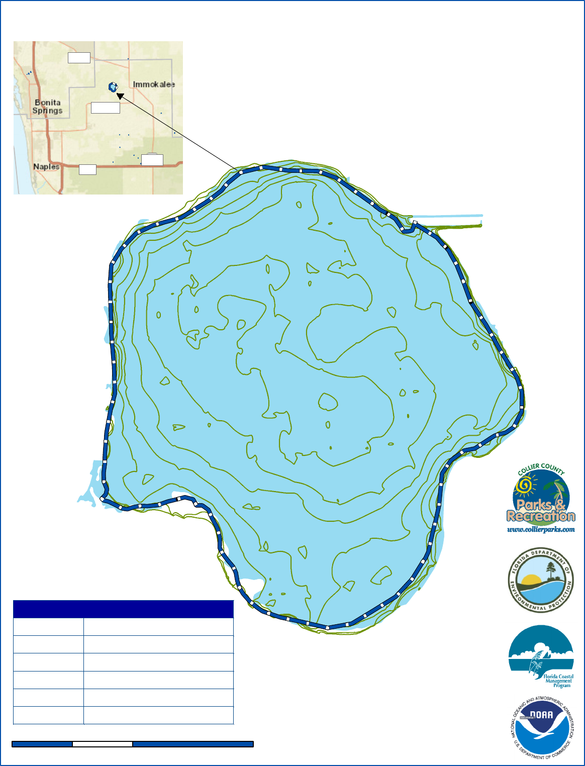
Lake Trafford
/
0 0.5 10.25
Miles
"
)
"
)
"
)
"
)
"
)
"
)
"
)
"
)
Collier
Lee
Hendry
I-75
FL 29
CR 846
FL 82
Lake Trafford Trail
Waypoint Latitude, Longitude
1 26.432778, -81.485861
2 26.432249, -81.504505
3 26.416180, -81.506682
4 26.408461, -81.491777
5 26.419096, -81.482621
