
Town of Cortlandt|Homeland Towers / Verizon Wireless 52 Montrose Station Road New Tower – Tech Memo
1 International Boulevard, 10th Floor, Suite 1000, Mahwah, NJ 07495-0027
(201) 335-9300
hdrinc.com
1
September 23, 2022
HDR Project #10346973
Town of Cortlandt
Town of Cortlandt Planning Board
1 Heady Street
Cortlandt Manor, New York 10567
Re: Homeland Towers / New York SMSA Limited Partnership d/b/a Verizon Wireless
Proposed Installation of a Wireless Telecommunications Facility
52 Montrose Station Road, Town of Cortlandt, Westchester County, NY
Dear Honorable Chairwoman Taylor and Members of the Town of Cortlandt Planning Board:
This memorandum was prepared to summarize HDR’s preliminary review of the application
materials submitted by Snyder & Snyder LLP, on behalf of the applicants, Verizon Wireless
(Verizon) and Homeland Towers, LLC (Homeland), for the above-referenced project. The
proposed wireless facility includes construction of a 140-ft monopole structure, of a new access
road, and a 930-s.f. ground-based equipment area located at the rear of the above-referenced 6-
acre property (located in a R-40 zoning district). Verizon is proposing to co-locate near the top of
the monopole (12 antennas; 137-ft antenna centerline height). The application in front of the
Planning Board is a re-design of an initial filing dated February 20, 2019 and is based in part on
Town comments that were submitted in March and April 2019 for the initial application (and in
September and October 2019 after additional applicant information was provided). Additional
information was submitted by the applicant in August 2021; however, at that time Verizon Wireless
requested that the Planning Board place the matter on hold status.
This Tech Memo was prepared for the Town Planning Board to assist in its ongoing Site Plan,
SEQRA, and Special Use Permit reviews for the proposed new wireless telecommunications
facility. The need for variances, such as from the ZBA for setback distances, should be confirmed
as the applicant has stated its current design does not require variances. HDR understands that
required permits and approvals will be confirmed by the Town. The Tech Memo includes a general
assessment of the application (including technical information from the applicants), focusing on
issues related to facility operation, capacity/coverage needs, and conformance with
electromagnetic radiation hazard criteria. In addition, potential aesthetic impacts and other aspects
of the proposed installation are discussed. This review consists of an analysis of the initial and
supplemental materials provided by the applicant as of the date of this Tech Memo.
The Tech Memo is divided into the following sections:
1. Application Overview
2. Summary of Application Filings
3. Coverage Needs
4. Conformance with NIER and Other Radiation Hazard Criteria
5. Alternate Site Analysis

Town of Cortlandt|Homeland Towers / Verizon Wireless 52 Montrose Station Road New Tower – Tech Memo
1 International Boulevard, 10th Floor, Suite 1000, Mahwah, NJ 07495-0027
(201) 335-9300
hdrinc.com
2
6. Visual Impact Analysis / Aesthetics
7. Co-location Potential
8. Cultural / Ecological Resources
9. Structural Assessment
10. Summary of Technical Review Findings and Recommendations
We note that this Tech Memo does not include comments that have been submitted by or may be
forthcoming from other Town consultants.
1. Application Overview
Initial Application (February 2019 – August 2021)
Verizon initially applied to construct a new wireless telecommunications facility at the above
referenced property in February 2019. At that time, Verizon was the sole applicant. The Town
provided comments on the filing in March and April of that year with an additional round of filings
and comments taking place later that year in September and October. Verizon re-designed the
facility based on the Town’s input and submitted a revised design in August 2021; however, shortly
after that, Verizon requested that the Town place the matter on hold.
Current Application (April 2022 to present)
In April 2022, the application was re-submitted by Verizon with Homeland Towers joining on as a
co-applicant. The current application proposes the construction of a new 140-ft tall conventional
monopole structure within a 930-square foot multi-carrier ground-based fenced equipment
compound at the base of the tower. The proposed tower location is toward the rear of the above
referenced ±6-acre property (52 Montrose Station Road; Section 44.7, Block 1, Lot 4) in a wooded
area. The property is currently operating as a horse stable (Sky Blue Stables) near the terminus
of Montrose Station Road and lies within an R-40 (single family residential) zoning district. The
parcel abuts the Blue Mountain Reservation (parkland) to the west and other residential parcels
on the remaining sides. A letter of authorization from the property owner authorizing Verizon and
its representatives to act as agent for the property owner was submitted as part of the initial (ca.
February 2019) application filings.
The following images are reproduced from the applicant’s latest (8-10-2022) construction
drawing set and annotated by HDR to highlight certain features.
Town of Cortlandt|Homeland Towers / Verizon Wireless 52 Montrose Station Road New Tower – Tech Memo
1 International Boulevard, 10th Floor, Suite 1000, Mahwah, NJ 07495-0027
(201) 335-9300
hdrinc.com
3
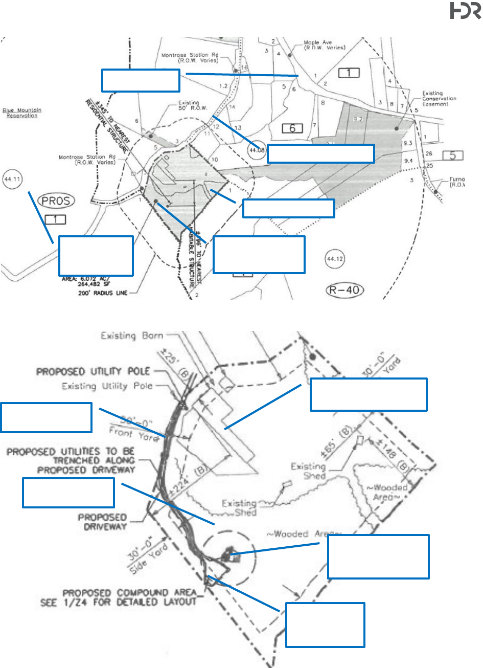
Radius Map (Drawing Z2, 8-10-22) Depicts the surrounding parcels.
Overall Site Plan (Drawing Z3 Detail 1, 8-10-22)
Subject Parcel
Proposed Tower
& Compound
Location
Montrose Station Rd.
Blue
Mountain
Res.
Maple Avenue
Proposed Tower &
Compound Location
Proposed Access
Drive
Nearest Habitable
Structure (196-ft away)
Proposed
Technician
Parking Area
Wooded Area
Town of Cortlandt|Homeland Towers / Verizon Wireless 52 Montrose Station Road New Tower – Tech Memo
1 International Boulevard, 10th Floor, Suite 1000, Mahwah, NJ 07495-0027
(201) 335-9300
hdrinc.com
4
Detailed Site Plan (Drawing Z3 Detail 2, 8-10-22) Depicts the surrounding parcels.
A 930 square foot equipment compound surrounded by an 8-ft tall chain-link fence with privacy
slats at the base of the tower is proposed. The compound has space for three ±150-square foot
ground-based equipment pads which can accommodate Verizon’s and two future co-located
carriers’ ground-based equipment. A new access driveway from the end of Montrose Station Road
roughly following the western edge of the parcel is proposed to facilitate construction and future
technician access to the facility. A small parking / turnaround area for maintenance vehicles is
included southwest of the equipment compounds and abutting the property boundary. Tree
removal is proposed to accommodate the construction of the access drive and compound with a
total of 19 trees proposed for removal. A preliminary tree removal plan is included as Drawing Z12
in the 8-10-2022 drawing set. Details on site grading were not provided.
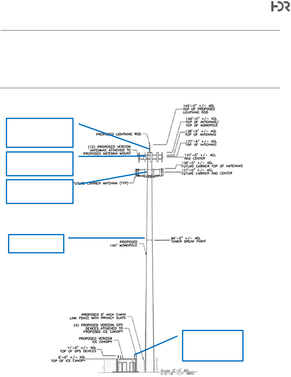
The proposed 140-ft tall conventional monopole structure will also have a lightning rod which
brings the total height to 145-ft. The applicant has proposed a galvanized gray finish for the tower.
No tower or site lighting is proposed, other than the timer light used for night maintenance.
Utilities(electric and telco) will be buried following the proposed access road. A telco cabinet and
utility board within the fenced area will service the facility.
Proposed Tower
Proposed Verizon
Equipment Pad
Equipment Space for
Future Co-locator
Proposed Equip.
Compound
(930 s.f.)
Proposed Collapse
Zone (56-ft radius)
Equipment Space for
Future Co-locator
Proposed Technician
Parking Area
Town of Cortlandt|Homeland Towers / Verizon Wireless 52 Montrose Station Road New Tower – Tech Memo
1 International Boulevard, 10th Floor, Suite 1000, Mahwah, NJ 07495-0027
(201) 335-9300
hdrinc.com
5
Compound Layout (Drawing Z4, 8-10-22) This drawing also depicts the antenna plan.
The Verizon antenna array is proposed to be mounted near the top of the tower with an antenna
centerline height of 137-ft above ground level (agl). The antenna array would consist of 12 panel
antennas arranged in three sectors (4 antennas per sector) oriented approximately north, east-
southeast, and south-southwest on an antenna sector mount. Other proposed tower-mounted
equipment includes two (2) remote radio head (RRH), and one (1) overvoltage protection box
(OVP) to be mounted behind the antennas on the mounting platform. At ground-level a 10-ft by
15-ft Verizon equipment pad is proposed. Proposed ground-based equipment includes one (1)
Verizon telco cabinet, one (1) equipment cabinet, one (1) battery cabinet, four (4) GPS units, and
one (1) 50kW diesel fired backup generator with sound attenuating enclosure to power the facility
in the event of an emergency (note – the generator is tested periodically outside of emergency
operations). An ice bridge will carry cabling from the equipment to the tower. Cabling will be routed
within the monopole structure. A small 100W incandescent light affixed to one of the ice canopy
supports and connected to a timer switch for nighttime maintenance operations is proposed. The
light will only be activated when necessary. The facility is not staffed, and technicians typically visit
once a month.
The following tables presents the dimensions of the proposed tower-mounted equipment as
provided by the applicant.
Proposed Tower
Proposed Verizon Panel
Antennas (4/sector)
Proposed Verizon RRH
(2/sector) and OVP (1/sector)
Equipment Area
(Future Co-Locator)
Equipment Area
(Future Co-Locator)
Proposed Verizon
Equipment Area
Access
Gate
Proposed Verizon
50kW Diesel
Backup Generator
Proposed Verizon
Equipment and
Battery Cabinets
Facility Telco
and Electric
Hook-ups &
Meter Board
Town of Cortlandt|Homeland Towers / Verizon Wireless 52 Montrose Station Road New Tower – Tech Memo
1 International Boulevard, 10th Floor, Suite 1000, Mahwah, NJ 07495-0027
(201) 335-9300
hdrinc.com
6
Proposed Verizon Equipment Item
Equip. Type
Height
Width
Depth
Weight
NHH-65B-R2B
Antenna
72.0
11.9
7.1
43.7
MT6407-77A
Antenna
35.06
16.06
5.51
81.57
XXDWMM-12.5-65-8T-CBRS
Antenna
12.3
8.7
1.4
2.87
Samsung RT4401-48A CBRS 4T4R
RRH + Antenna
13.91
8.55
4.15
18.64
Samsung LTE 700/850MHZ RFV01U-D2A
RRH
15.5
15.9
10.0
70.3
Samsung LTE AWS/PCS RFV01U-D1A
RRH
15.5
15.9
10.0
70.3
Raycap 6-Circuit
OVP
19.15
15.73
10.31
37.5
Dimensions are given in inches. Weight is given in pounds.
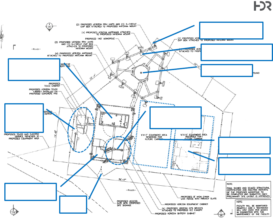
East Tower Elevation Detail (Drawing Z6 Detail 2, 8-10-22) Note that this drawing depicts a second co-located
antenna array. The applicant has noted interest from another, unnamed carrier. Additional co-location is not depicted
on this detail.
Proposed Verizon
Antenna Array
(±137’-0” centerline)
Future Co-located
Carrier’s Antenna Array
(±127’-0” centerline)
Tower Hinge Point
(84’-0”)
Proposed Verizon
Equipment Shelter
(Top of GPS: 11’-0”)
(Top of Canopy: 9’-0”)
Proposed Top
of Monopole
(140’-0” tower)
(145’-0” lightning rod)
Town of Cortlandt|Homeland Towers / Verizon Wireless 52 Montrose Station Road New Tower – Tech Memo
1 International Boulevard, 10th Floor, Suite 1000, Mahwah, NJ 07495-0027
(201) 335-9300
hdrinc.com
7
Verizon is licensed to operate in the 700, 850, 1900, 2100, 3500, and 3700 MHz frequency bands,
which provide various classes of service (4G/LTE, PCS, and 5G). The applicant has stated in
their NIER compliance report prepared by Pinnacle Telecom Group that high-frequency
1
(“mm-Wave”) 5G technology is not proposed as part of this application. The tower location
was originally proposed by Verizon prior to Homeland Towers’ involvement and was selected by
Verizon to fill a gap in coverage in the area. Additional details and discussion are included in later
sections of this Tech Memo.
Tower Re-design Comparison to Initial Design
As noted above, the tower and ground-based compound were re-designed prior to the 2022
application filings. In broad terms the re-design included relocating the tower on the parcel
(approximately 150-ft shift northwest of original); changing the proposed structure type from a self-
support lattice tower to a traditional monopole (based on prior Town feedback); and reducing the
total area of the ground-based equipment compound. A table summarizing the changes between
the initial and current design is included below. This table is an adaptation of one included by
Scherer Design Group, LLC (“SDG”; applicant’s design engineer) in the applicant’s response to
HDR’s “Memo #1” (dated July 7, 2022).
Item
Initial Application
Current Homeland/Verizon Application
Letter of Authorization
Provided
Update includes Homeland Towers
Latitude/Longitude
41° 16’ 09.00”
-73° 53’ 48.00”
41° 16’ 11.15”,
-73° 53’ 48.26”
±150ft northwest of initial application
location
Property Survey
provided?
Provided in response to comments.
Survey attached to revised drawings dated
8/10/2022. [submitted with August 24,
2022 filing]
Setback distances/
property lines and area
variance needs
Town Code Section 307-17
Initial
Application
Current
Application
Required
Existing
Proposed
Proposed
Min. Lot Area
40,000 s.f.
261,664 sf
No Change
No Change
Min. Lot Width
150 ft
552 ft
No Change
No Change
Max Height
2 ½ Stories /
35 ft
1 ½ stories /
±20 ft
± 9 ft (equip.
canopy)
± 9 ft (equip.
canopy)
Min. Front Yard
50 ft
±25 ft *
±221
±189 ft 7 in
Min. Side Yard
30 ft
±65 ft
±7 ft * *
±62 ft 3 in
Min. Rear Yard
30 ft
±148 ft
±66 ft
±181 ft
Max. Bldg. Coverage
65% of F.A.R.
±3%
±3.07%
±3.35%
Min. Landscape Cover.
60%
±72%
±69%
±69%
* Existing Non-conformity
** Waiver required
Ground elevation,
compound (ft amsl)
435’ ± (NAVD88)
410’-6” ± (NAVD88)
Ground elevation, tower
(ft amsl)
445’ ± (NAVD88)
410’-6” ± (NAVD88)
Tower type proposed
Lattice
Monopole
Tower height (ft agl)
±140’ (±145’ for lightning rod)
±140’ (±145’ for lightning rod)
Ground-based
equipment compound
(size, s.f.)
±1,425 s.f.
±929 s.f.
1
High-frequency 5G (aka “mmWave”) includes frequencies between 28,000 and 39,000 MHz (28 to 39 GHz).

Town of Cortlandt|Homeland Towers / Verizon Wireless 52 Montrose Station Road New Tower – Tech Memo
1 International Boulevard, 10th Floor, Suite 1000, Mahwah, NJ 07495-0027
(201) 335-9300
hdrinc.com
8
Item
Initial Application
Current Homeland/Verizon Application
SEQRA EAF submittal
Yes
Yes – Noted edits made to prior version.
**Verification needed from applicant on
whether the 8/17/2021 EAF is the most
current version.
SHPO determination
Yes, see SEQRA Submission
Update pending.
Referrals (municipalities
and county)
Adjacent municipalities and county
Town confirmed project referrals sent are
compliant.
Tree survey
Yes (12/20/2019)
See Z-12 of revised drawings dated
8/10/2022. [submitted with August 24,
2022 filing]
# Trees to be removed
35
19
Existing utilities included
on Drawings
Yes
Yes
Visual Impact Analysis
(Balloon test)
Yes – May 4, 2019 balloon test and August
2019 Visual Resource Evaluation from
Saratoga Associates
July 23, 2022 balloon test and August 2022
Visual Resource Evaluation by Saratoga
Associates [submitted with August 24,
2022 filing]
Photosimulations and
viewshed maps provided
Included in the August 2019 Visual
Resource Evaluation from Saratoga
Associates.
Included in August 2022 Visual Resource
Evaluation from Saratoga Associates
[submitted with August 24, 2022 filing]
Viewshed analysis – net
area of visibility
(acreage)
Included in the August 2019 Visual
Resource Evaluation from Saratoga
Associates.
Included in August 2022 Visual Resource
Evaluation from Saratoga Associates
[submitted with August 24, 2022 filing]
Requested Waivers
(Chapter 277)
Minimum side yard
Minimum side yard setback met by re-
design.
2. Summary of Application Filings
For the purposes of this Tech Memo, the materials received in 2022 as part of the application
filings are considered in conjunction with relevant older documents submitted for the original
application that have not been superseded or rendered irrelevant due to the re-design. It is noted
that some items received in 2022 are updated versions of (and therefore supersede) prior versions
of the same document (e.g., construction drawings).
The following items were received and reviewed by HDR:
• Initial Applicant Filing. Snyder & Snyder LLP dated February 21, 2019 (105 pp.) that
includes the following:
o Cover letter (2 pp.)
o Planning Board Application form for a special permit (2 pp.)
o Letter of Authorization from property owner (Bezo Enterprises, LLC); 1 page
o Copies of application referral letters to Westchester County Planning Department and
adjacent municipalities (all dated February 20, 2019). The following municipalities were
noticed: Village of Buchanan, City of Peekskill, Village of Croton-on-Hudson, Village of
Highland Falls, Town of Highlands, Town of New Castle, Town of Ossining, Town of
Philipstown, Town of Putnam Valley, Town of Stony Point, and Town of Yorktown.
o Statement in Support of the proposed wireless facility (February 20, 2019; 7 pp.) with the
following Exhibits attached:

Town of Cortlandt|Homeland Towers / Verizon Wireless 52 Montrose Station Road New Tower – Tech Memo
1 International Boulevard, 10th Floor, Suite 1000, Mahwah, NJ 07495-0027
(201) 335-9300
hdrinc.com
9
Exhibit 1 – Structural Certification Letter (Scherer Design Group, LLC dated
February 8, 2019; 1 pp.), noting design criteria to be used and that the tower will
be designed to accommodate up to four co-locators
Exhibit 2 – Antenna Site FCC RF Compliance Assessment and Report (Pinnacle
Telecom Group dated December 19, 2018; 18 pp.), attesting that the cell site
would comply with FCC health-based criteria should it be approved and
operational (Verizon only; future co-location was not considered).
Exhibit 3 – FCC Licenses (10 pp.)
Exhibit 4 – Alternative Site Analysis (2 pp.) attesting to the fact that there are no
existing towers or other tall structures upon which to co-locate and no viable non-
residentially zoned properties that would meet Verizon’s service needs
Exhibit 5 – Full SEQRA Environmental Assessment Form (dated February 19,
2019; 13 pp. with 4-page attachment indicating there are no wetlands or
waterbodies at the project site, and providing correspondence from SHPO (May
2018) noting no direct or visual effects on historic properties within the Area of
Potential Effects (APE)
Exhibit 6 – RF Report (C Squared Systems LLC dated February 20, 2019; 16 pp.).
• Drive Test data (700 MHz and 2100 MHz), from a November 1, 2017 field
study
• Tables 1 and 2 (and map) inventorying existing and proposed Verizon cell
sites in the site area
• Coverage maps (low band and high band), depicting existing Verizon
coverage in the area
• Coverage maps (low band and high band), depicting existing Verizon
coverage in the area with the proposed site at 52 Montrose Station Road
Site Plan Drawing set (Scherer Design Group, LLC dated February 8, 2019; 10
sheets)
• Review Memorandum to the Planning Board (Town of Cortlandt Department of Technical
Services Engineering Division, dated March 11, 2019; 3 pp.), based on a review of the
February 21, 2019 applicant submittal
• Comment Letter (review of application material) by Center for Municipal Solutions on behalf of
the Town, dated April 19, 2019, and updated October 16, 2019; 16 pp.
• Visual Resource Assessment (Saratoga Associates, dated April 27, 2019; 45 pp.)
o Narrative describing project description, landscape setting, viewshed analysis, scenic
resources and areas of local interest in the vicinity of the proposed site, and the
methodology followed during the May 4, 2019 balloon test
o Listing of and visibility comments for 29 photo viewpoints (VPs) taken during the May
2019 balloon test
o 2 viewshed maps (bare earth and land cover included); 2-mile and 1-mile radius. The
29 VPs are included on these maps.
o Photolog of balloon test VPs (29)
o Photosimulations (7) for the then-proposed lattice tower design (at the initially-
proposed location on the site)
• Review Memorandum to the Planning Board from the Town Department of Technical Services
Engineering Division dated September 25, 2019; 5 pp.
• Tree Survey (Bartlett Tree Experts) dated December 20, 2019; 2 pp. 127 existing trees were
identified and tagged.

Town of Cortlandt|Homeland Towers / Verizon Wireless 52 Montrose Station Road New Tower – Tech Memo
1 International Boulevard, 10th Floor, Suite 1000, Mahwah, NJ 07495-0027
(201) 335-9300
hdrinc.com
10
• Response-to-Comment filing by the applicant (dated August 18, 2021; 62 pp.):
o Cover letter with responses-to-comments provided on prior application submittals,
including re-located monopole configuration and revised design of the tower to a
monopole (10 pp.)
o RF engineer (C-Squared) supplemental report, dated August 12, 2021 (16 pp.)
Response-to-comment narrative
Updated low- and high-band Verizon coverage maps for the existing
conditions (i.e., without the proposed cell site) and with the site proposed at
52 Montrose Station Road
Alternate height coverage maps
o Updated EAF, dated August 7, 2021; 13 pp. with 3-page attachment
o Structural Letter, prepared by SDG and dated August 5, 2021 (1 page)
o Copy of FCC license (2 pp.)
o Updated Site Plan Drawing set (SDG, dated August 5, 2021; 11 sheets) This
Drawing set was assumed to be the latest as of the date of HDR’s initial review
(Memo #1 dated July 7, 2022).
• Cover letter to the Planning Board (Snyder & Snyder LLP dated April 12, 2022; 5 pp.) with an
updated Planning Board application naming Homeland Towers LLC as the Applicants (2 pp.)
and an updated Proxy Statement (1 pp.)
After reviewing the supplied information listed above, HDR submitted its Review Memo #1 (“Memo
#1”) dated July 7, 2022. Memo #1 provides an inventory and assessment of completeness of the
application materials received and includes requests for supplemental information. This memo
included comments and requests for supplemental information covering the proposed balloon test,
the visual resources evaluation, an inventory of project changes, the RF justification, design
drawings and specifications, RF emissions, and structural analysis components of the application.
Shortly after Memo #1 was submitted, conversations coordinating the proposed balloon test were
had between the applicant, HDR, and the Town. On July 15, 2022 HDR received an updated
viewshed analysis map prepared by Saratoga Associates (undated, 1 page) reflecting the change
in the proposed location of the tower (prior versions of the viewshed map depicted the original
tower location).
In August 2022 HDR received the applicant’s responsive filing prepared and submitted by the
applicant’s attorney and dated August 24, 2022. Included in this filing were the following:
• Comment Response Letter prepared by Snyder & Snyder dated August 24, 2022 (12 pp.). The
following exhibits were attached:
o Exhibit 1 – Updated Visual Assessment (Saratoga Associates dated August 18, 2022; 53
pp. including attachments)
o Exhibit 2 – Structural Response to Comments Letter (Scherer Design Group dated August
10, 2022; 4 pp.)
o Exhibit 3 – RF Justification Response to Comments (C Squared Systems dated August 19,
2022; 45 pp. including exhibits listed below)
Exhibit A – Table of Existing and Proposed Sites (1 pp.)
Exhibit B – Figures showing existing and proposed 750 MHz coverage signal
strengths (2 figures)
Exhibit C – Copies of FCC licenses (37 pp.)

Town of Cortlandt|Homeland Towers / Verizon Wireless 52 Montrose Station Road New Tower – Tech Memo
1 International Boulevard, 10th Floor, Suite 1000, Mahwah, NJ 07495-0027
(201) 335-9300
hdrinc.com
11
o Exhibit 4 – Antenna Site FCC RF Compliance Assessment and Report (Pinnacle Telecom
Group dated July 19, 2022; 18 pp.), attesting that the cell site would be compliant with FCC
health-based criteria should it be approved and operational. This version is assumed to
supersede the prior version and was considered for this Tech Memo.
• Site Plan Drawing Set (SDG, dated 8-10-2022; 13 sheets)
This drawing set is assumed to be the latest as of the date of this Tech Memo and superseded
prior versions.
The applicant’s responses to HDR’s comments and the supplemental information supplied appear
to be responsive, and the combined application materials / filings appear to be comprehensive
and in accordance with the requirements of the Town of Cortlandt Wireless Code (Chapter 277)
unless otherwise noted.
3. Coverage Needs
Background
The frequencies involved in the operation of Verizon’s wireless network require a line-of-sight for
signal propagation pathways for their performance with some enhancement gained from
reflections off of solid structures or surfaces. Wireless telecommunications networks are divided
into “cells” serviced by a given wireless facility. When considering a regional wireless
telecommunications network, it is necessary that adjacent facilities exist in order to provide
uninterrupted service so that call traffic can be passed between cells within in a given area of a
provider’s cellular network.
When evaluating the need for a new wireless telecommunications facility, a number of factors are
typically considered by a carrier. The network coverage and/or capacity directly impact the quality
of service provided by the network. Coverage is the geographic area of service provided by a given
facility at a given operating frequency and signal strength. Capacity is the number of callers and
data users (connections) that can be simultaneously handled by the network equipment at a given
cell site. The proliferation of mobile devices such as smart phones, tablets, connected vehicles,
and other devices has increased the need for network capacity even in areas that were once
considered “covered” during the early roll-out of wireless technology. Industry focus has shifted
from trying to cover large geographic areas with a single facility (e.g., several square miles) to
“capacity coverage” (increase of capacity through network densification) in order to meet
subscriber demand for bandwidth intensive services. An inability to meet demand results in
overloaded networks, degraded call quality, and slow or interrupted services (e.g., slow internet
and dropped calls).
Applicant’s Objective
Based on the information provided by the applicant, the primary purpose of the proposed facility
at 52 Montrose Station Road is to increase Verizon’s network coverage in areas that are currently
lacking reliable service or are underserved by the existing Verizon network.

Town of Cortlandt|Homeland Towers / Verizon Wireless 52 Montrose Station Road New Tower – Tech Memo
1 International Boulevard, 10th Floor, Suite 1000, Mahwah, NJ 07495-0027
(201) 335-9300
hdrinc.com
12
Verizon submitted a report (“RF Report”) prepared by C Squared Systems, LLC (“C Squared”)
dated February 20, 2019 with its original application filings documenting its need for, and rationale
in selecting, the proposed site. Note that this document was prepared for the originally proposed
location which is approximately 150-ft away from, and approximately 35-ft higher in elevation than
the current proposed location; however, the discussion surrounding the site selection process
provided in this document remains relevant. Furthermore, the applicant has testified in its August
2022 responsive filing that the gap in coverage remains.
The 2019 C Squared RF Report provides a combination of propagation modeling (“coverage
maps”) and field drive/scan test data as its evidence that a gap in service exists in Verizon’s
network in the vicinity of the proposed location. Propagation modeling is a common tool used by
providers to simulate network coverages and identify potential gaps. C Squared utilized a
predictive computer modeling program called “deciBel Planner RF” to develop coverage maps.
This software considers land use, topography, equipment configurations and power levels, signal
propagation behavior, and other inputs to produce images of predicted coverages from both the
existing network sites and the proposed site. The report also notes that Verizon conducted a drive
test (sometimes called a “scan test” or “drive scan test”) in November 2017. This was
accomplished by driving a vehicle equipped with electronic test equipment and receivers on public
roads to collect real-world signal data through the study area. Although data recorded from public
roadways does not capture signal from the entirety of land within a search area, these field data
were used to calibrate the predictive model output produced by the software by comparing field
measurements to the model output and adjusting model input parameters until reasonable amount
of correlation between known and predicted outcomes was achieved.
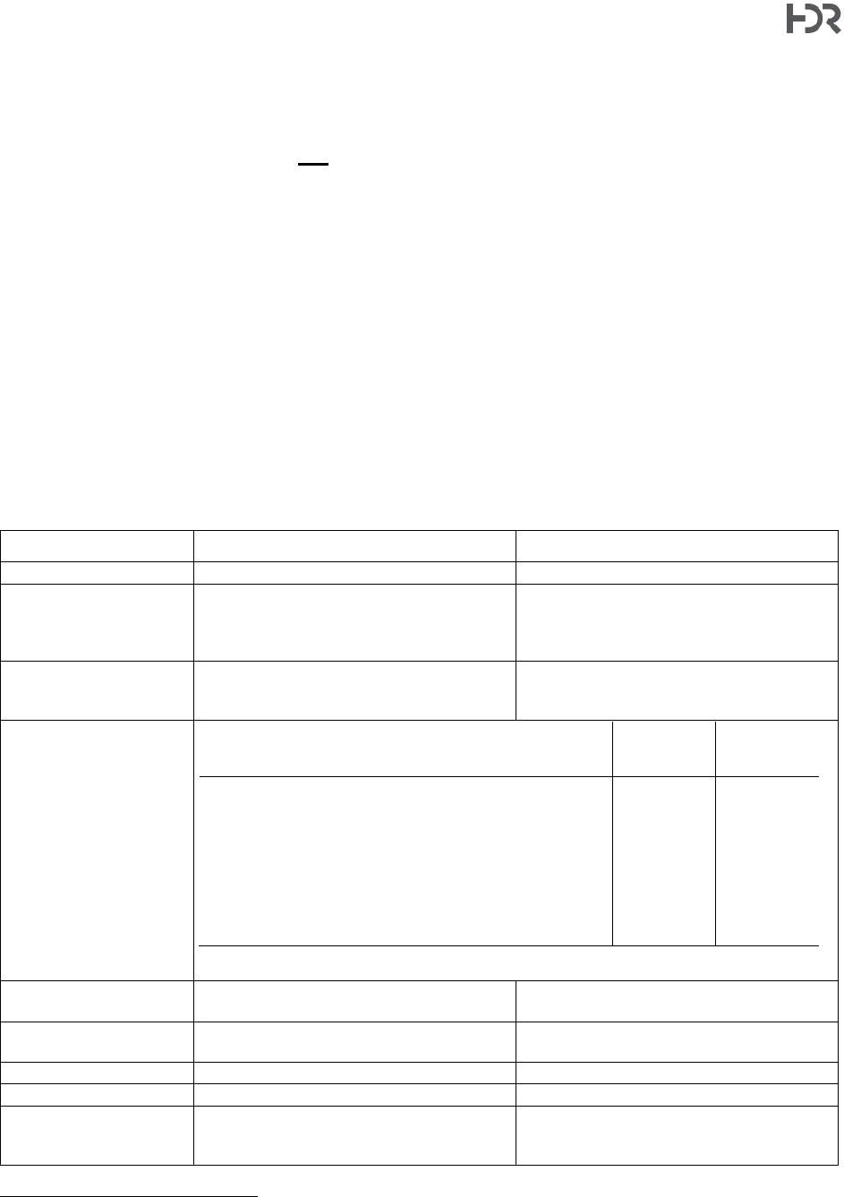
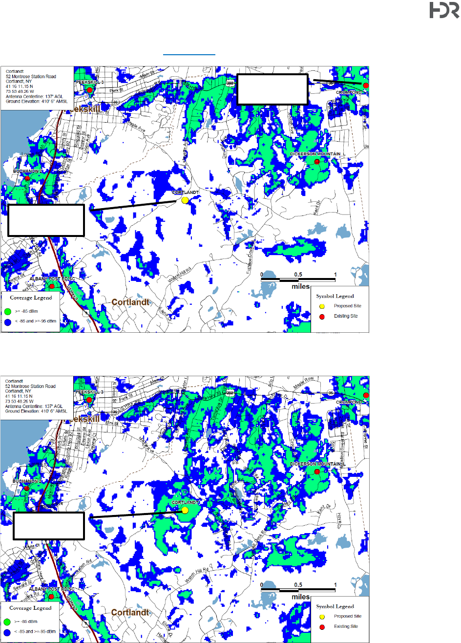
The February 2019 C Squared report presents drive test data collected in November 2017 for the
750 MHz (‘low band’) and 2100 MHz (‘high band’) frequency ranges that are proposed by Verizon
as well as the predicted existing and proposed coverages on several figures. Two figures depicting
the 750 MHz band are reproduced below as they are the primary basis for the applicant’s case
that a gap in coverage exists. It is important to note that 750 MHz is a longer wavelength that
propagates further and is less impeded by physical obstacles such as terrain and foliage, which
means it will cover a larger area than the 2100 MHz frequency band. Even though other licensed
frequency bands are employed by Verizon in their network operations, the 750 and 2100 MHz
bands provide an idea of “best” and “worst” case scenarios, respectively.
Signal strength is reported in decibel-milliwatts / reference signal received power (dBm RSRP) on
the C Squared figures
2
. The closer the value is to 0, the stronger the signal is. In the figures below,
signal strengths are given in groups that represent areas where in-building service is possible (>=
-85 dBm, green shading), in-vehicle service is possible (-85 dBm to -95 dBm, blue shading), and
where service is poor or non-existent (no shading). Existing sites are shown as red dots and the
proposed site is shown as a yellow dot.
2
Note – though not clearly stated in the various C Squared reports, HDR confirmed with the RF engineer that the signal strengths
depicted on the drive test data and signal propagation maps are provided in dBm of reference signal received power (RSRP).
Town of Cortlandt|Homeland Towers / Verizon Wireless 52 Montrose Station Road New Tower – Tech Memo
1 International Boulevard, 10th Floor, Suite 1000, Mahwah, NJ 07495-0027
(201) 335-9300
hdrinc.com
13
Drive Test Data - Existing Coverage, 750 MHz (C Squared RF Report, 2019)
Modeled Existing Coverage, 750 MHz (C Squared RF Report, 2019)
Approximate 750
MHz Coverage Gap
identified by Verizon
Approximate Area
Shown in Modeled
Coverage Map
Below
Proposed Site
Proposed Site
Town of Cortlandt|Homeland Towers / Verizon Wireless 52 Montrose Station Road New Tower – Tech Memo
1 International Boulevard, 10th Floor, Suite 1000, Mahwah, NJ 07495-0027
(201) 335-9300
hdrinc.com
14
Existing Verizon Sites
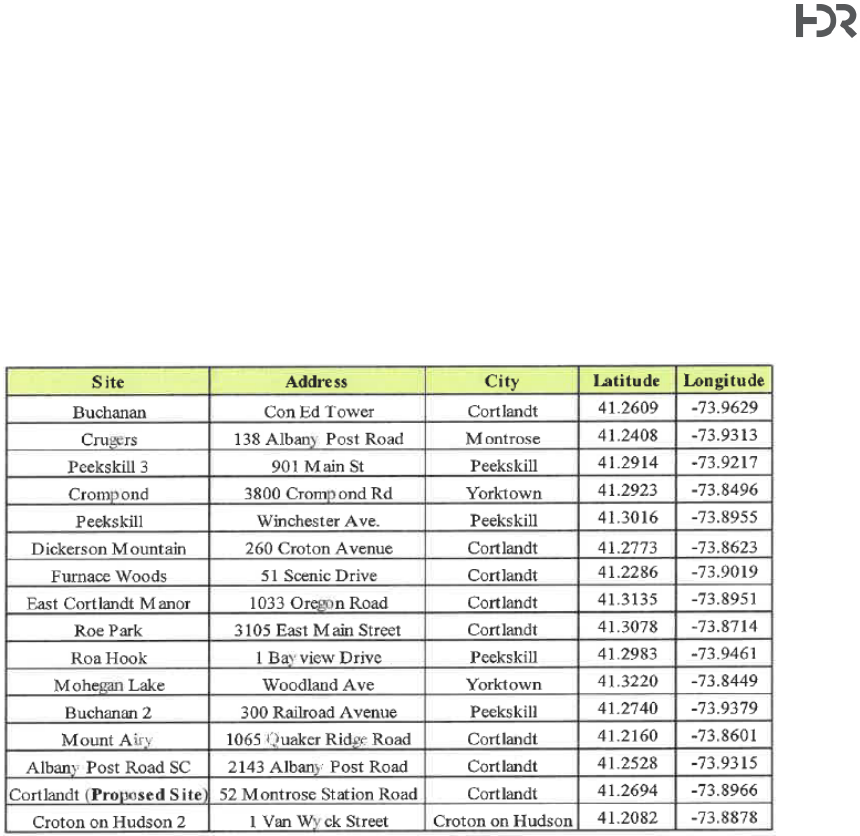
Verizon’s RF engineer provided the following list of 16 existing and proposed sites in the general
vicinity of the proposed location in their August 2022 responsive filing. This table was noted to
have been updated to reflect locations that were proposed but not necessarily on-air during the
original application review. The RF engineer additionally states that coverage footprints have not
changed for the surrounding sites since the original filings and that the identified gap in coverage
remains.
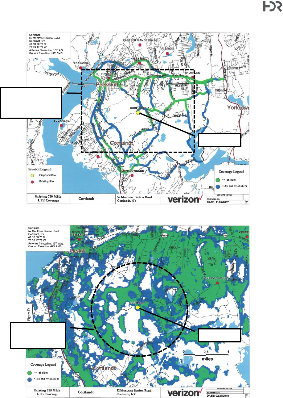
Coverage Need
As previously noted, the applicant has stated that the proposed tower is intended to fill a coverage
gap in its network. The following images are taken from predicted coverage maps updated to
reflect current (as of August, 2022) network conditions and included in C Squared’s August 2022
responsive filing. The figures present the current and proposed 750 MHz coverages, which
provides a more optimistic view of network coverage as the signal tends to propagate further than
higher frequencies and therefore higher frequency bands would have a smaller footprint. Updated
coverage maps for other, higher frequencies were not provided by the applicant citing the fact that
the coverages would be smaller.
Town of Cortlandt|Homeland Towers / Verizon Wireless 52 Montrose Station Road New Tower – Tech Memo
1 International Boulevard, 10th Floor, Suite 1000, Mahwah, NJ 07495-0027
(201) 335-9300
hdrinc.com
15
Existing 750 MHz LTE Coverage (C Squared Supplemental Filing, August 2022).
Annotations added by HDR. Green shading = signal stronger than -85 dBm (in-building).
Blue shading indicates in-vehicle coverage (-85 dBm to -95 dBm). White areas indicate poor or no coverage.
Existing and Proposed 750 MHz LTE Coverage (C Squared Supplemental Filing, August 2022).
Annotations added by HDR.
Proposed
Site
Areas where coverage
is predicted by the
applicant to improve.
Proposed Site
(Yellow Dot)
Existing Site
(Red Dot)
Town of Cortlandt|Homeland Towers / Verizon Wireless 52 Montrose Station Road New Tower – Tech Memo
1 International Boulevard, 10th Floor, Suite 1000, Mahwah, NJ 07495-0027
(201) 335-9300
hdrinc.com
16
The following two images are from the August 2021 filing. It is assumed based on statements made by the
applicant in the August 2022 filings that the coverages depicted below remain relevant.
Existing 2100 MHz AWS Coverage (C Squared Supplemental Filing, August 2021).
Annotations added by HDR. Green shading = signal stronger than -85 dBm (in-building).
Blue shading indicates in-vehicle coverage (-85 dBm to -95 dBm). White areas indicate poor or no coverage.
Existing and Proposed 2100 MHz AWS Coverage (C Squared Supplemental Filing, August 2021).
Annotations added by HDR.
Proposed Site
(Yellow Dot)
Existing Site
(Red Dot)
Proposed
Site

Town of Cortlandt|Homeland Towers / Verizon Wireless 52 Montrose Station Road New Tower – Tech Memo
1 International Boulevard, 10th Floor, Suite 1000, Mahwah, NJ 07495-0027
(201) 335-9300
hdrinc.com
17
The proposed coverage area, per the 2019 C Squared report, notes that with the 750 MHz
frequency band approximately 2.3 square miles of area, ±1,900 people, and 10.7 miles of roadway
will be serviced with in-vehicle coverage. Additionally new in-building service would cover 2.2.
square miles and approximately 2,400 people.
HDR notes that the proposed coverage area based on the figures provided could reach areas (and
roadways that connect these areas) such as the Valeria neighborhood to the south, the Chapel
Hill neighborhood to the north in the City of Peekskill, Blue Mountain Middle School and Furnace
Brook Middle School, portions of the Blue Mountain Reserve, and other nearby residential,
commercial, and institutional land uses.
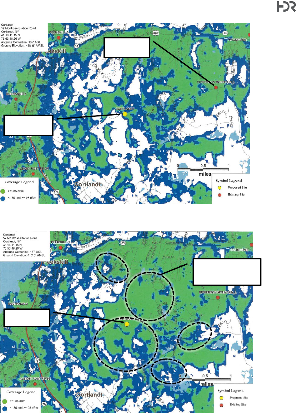
Tower Height
The applicant is proposing a 140-ft tall conventional monopole design. Town Code §277-9 states
that towers shall be no taller than the minimum height necessary and stipulates a presumed
maximum height of 140-ft.
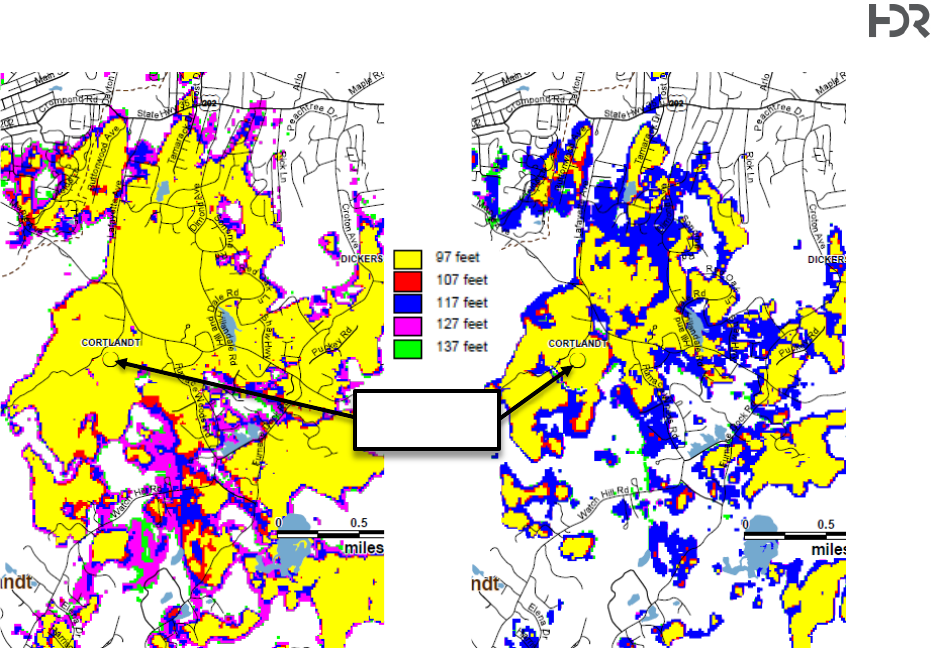
In the August 2021 C Squared report, figures that depict -85 dBm (in-building) and -95 dBm (in-
vehicle) coverages for a series of antenna centerline elevations including 97, 107, 117, 127, and
137 (the proposed Verizon antenna height) were provided [note – these figures are post-re-
design/re-location]. In the C Squared figures, which are reproduced in part below, each height’s
coverage is represented by a unique color. Signal coverage from each height overlaps with each
“step” down (i.e., coverage from 137-ft will reach the farthest and entirely contain each height
below it). The applicant’s RF engineer stated in its August 2021 responsive filing that a height less
than the proposed height would reduce Verizon’s coverage and limit coverage of any future co-
locators. Per the RF engineer, for both -85 dBm and -95 dBm the coverage of antennas mounted
at 137 ft compared to 97 ft is approximately 55 to 57% less. Additionally, the elevation of the
currently proposed tower location is approximately 35-ft lower than the originally proposed
location.
Town of Cortlandt|Homeland Towers / Verizon Wireless 52 Montrose Station Road New Tower – Tech Memo
1 International Boulevard, 10th Floor, Suite 1000, Mahwah, NJ 07495-0027
(201) 335-9300
hdrinc.com
18
Predicted 750 MHz Coverage at -95 dBm (in vehcile)
for each height shown.
Predicted 750 MHz Coverage at -85 dBm (in
building) for each height shown.
Summary of RF Justification Review
RF Reports and data were submitted by C-Squared with the initial application filing (report dated
February 20, 2019, including drive test data, existing and proposed cell site information, and
coverage maps) and in August 2021 in response to Town comments. Based on the information
provided, a gap in Verizon service has been depicted for the site area.
The applicant’s RF engineer has provided technical information that attests to the need for the
proposed tower location such that a gap in Verizon’s coverage has been identified. Potential
coverage from nearby towers, as noted above, is impeded by terrain, foliage, and distance to the
targeted coverage gap.
Though the intent of the applicant in the alternative height analysis figures was to show that lower
heights would not provide satisfactory coverage of the targeted area, the Town may also wish to
consider that the representations of coverage from alternative heights provided by the applicant
can serve as a proxy for potential coverage of hypothetical future co-locators. Co-location on an
existing structure is the Town’s highest priority for siting of new wireless facilities. As noted by the
applicant, an unnamed co-locator has expressed interest in the currently proposed location (should
the proposed tower be approved and constructed).
Proposed
Tower Location

Town of Cortlandt|Homeland Towers / Verizon Wireless 52 Montrose Station Road New Tower – Tech Memo
1 International Boulevard, 10th Floor, Suite 1000, Mahwah, NJ 07495-0027
(201) 335-9300
hdrinc.com
19
4. Conformance with NIER and Other Radiation Hazard Criteria
In order to comply with the Non-Ionizing Electromagnetic Radiation (NIER) hazard criteria,
Pinnacle Telecom Group (on behalf of the applicants) calculated power density levels (also
referred to herein as radio frequency [RF] levels) for the proposed installation. The analysis,
included in a report dated July 19, 2022, demonstrated compliance with the FCC’s general public
maximum permissible exposure (MPE) limit in the vicinity of the site, and considered the following
FCC-licensed frequencies used by Verizon: 700, 850, 1900, 2100, 3500, and 3700 MHz. It is
noted that high-frequency (“mm-Wave”) 5G technology is not proposed as part of this
application. The analysis also conservatively included three additional carriers and assumptions
about their potential equipment, power settings, and operations (hypothetical carriers included
AT&T, DISH, and T-Mobile).
Based on the modeling presented, which include the assumptions about a “full” co-location
scenario, as described above, the maximum anticipated RF levels are anticipated to be on the
order of 4.43% of the FCC’s general public MPE limit in the vicinity (within 500-ft) of the proposed
wireless transmission facility at ground level. HDR has reviewed the methodologies and findings
of the Pinnacle report and based on this review and our experience at wireless telecommunications
facilities, agrees that the RF levels from the proposed facility will be compliant with (below) the
appropriate MPE limit at ground level.
5. Alternate Site Analysis
Section 277-7 of the Town of Cortlandt’s Code establishes the order in which locations may be
considered for a wireless telecommunications facility. Higher priority sites may not be bypassed
without satisfactorily demonstrating why other locations are impractical. The priority established
by the Code is as follows:
a. On an existing telecommunications tower or other tall structure
b. Co-location on a site with an existing tower or structure
c. In non-residentially zoned areas of the Town, including municipally owned properties
d. In non-residentially zoned areas of the Town
e. On other property in the Town.
The location proposed by the applicant is of the lowest priority. An affidavit of John Pepe, a site
acquisition consultant retained by Verizon, attests to the search for higher priority sites and that
none were found that were suitable or that would satisfy Verizon’s stated coverage need. The
February 2019 C Squared report also notes that a search for existing towers and/or other tall
structures was performed and did not identify any nearby suitable towers/structures stating that
existing locations would not provide the targeted coverage.
The gap identified by Verizon largely overlaps with R-40 single family residential zoning and open
space districts (e.g., Blue Mountain Reservation), leaving no or limited options that satisfy the
requirement to site on non-residentially zoned or Town owned properties. As noted by the

Town of Cortlandt|Homeland Towers / Verizon Wireless 52 Montrose Station Road New Tower – Tech Memo
1 International Boulevard, 10th Floor, Suite 1000, Mahwah, NJ 07495-0027
(201) 335-9300
hdrinc.com
20
applicant and reviewed by HDR via map / terrain assessment and site reconnaissance, existing
nearby towers are not able to service the targeted gap area due to distance or terrain which
prevents co-location on an existing structure or wireless facility.
In summary, HDR has reviewed the attestations made and technical information filed by the
applicant with regard to site selection and the lack of available alternative sites and feels that the
information presented is reasonable in justifying that potential alternative sites are not viable to
provide the coverage needs as identified by Verizon. HDR also used its own site reconnaissance
including desktop reviews and general knowledge of the area in its review of the applicant’s filed
materials. As such, the location at 52 Montrose Station Road (as proposed) appears
reasonable based on a lack of viable alternatives or higher priority sites in the area to meet
the applicant’s current service needs.
6. Visual Impact Analysis / Aesthetics
The applicants submitted a Visual Resource Assessment (VRA) in support of the proposed facility.
It should be noted that an older VRA report was developed for the original application; however,
discussion thereof is not included below due to the relocation and re-design of the tower. The
current VRA was prepared by Saratoga Associates (“Saratoga”) dated August 18, 2022 considers
the current tower design (monopole) and location within the subject parcel. The VRA document
includes a short narrative, information on the development of the viewshed analysis (computer
prediction of where the tower may be visible), identification of visual resources, documentation of
the balloon visibility test that was conducted on July 23, 2022, photographs collected during the
balloon test, and photosimulations of the proposed tower from various viewpoints within the survey
area. The VRA performed by Saratoga establishes a two-mile viewshed radius around the
proposed tower site for their evaluation citing that the viewshed analysis that they performed
indicates that views beyond this radius will be substantially screened by topography or vegetation.
Viewshed Analysis
Saratoga Associates performed a viewshed analysis and developed viewshed overlays using
Global Mapper 23.0 (a geographic information system (GIS) software) and publicly available Light
Detection and Ranging (LiDAR) data. A digital surface model which captures the natural (bare)
and built surfaces of the earth was created from the LiDAR data points. The software has a built-
in viewshed analysis tool which develops line-of-sight visibility areas based on various inputs such
as the viewer’s height (about 6ft) and the facility’s maximum height (140-ft). Two viewshed
overlays were developed to present a theoretical maximum viewshed (“bare earth”), and another
with views obscured by clutter such as mature vegetation and structures. Bare earth models are
conservative (e.g., show a larger area of potential visibility) and do not necessarily represent “leaf
off” conditions as deciduous tree branches provide some level of screening even in winter.
The image below is Figure A1 from the Saratoga VRA, which depicts a 2-mile radius from the
proposed facility and the associated potential views –with both bare earth and land cover
(screening due to vegetation/structures) overlays showing. Saratoga included the positions where
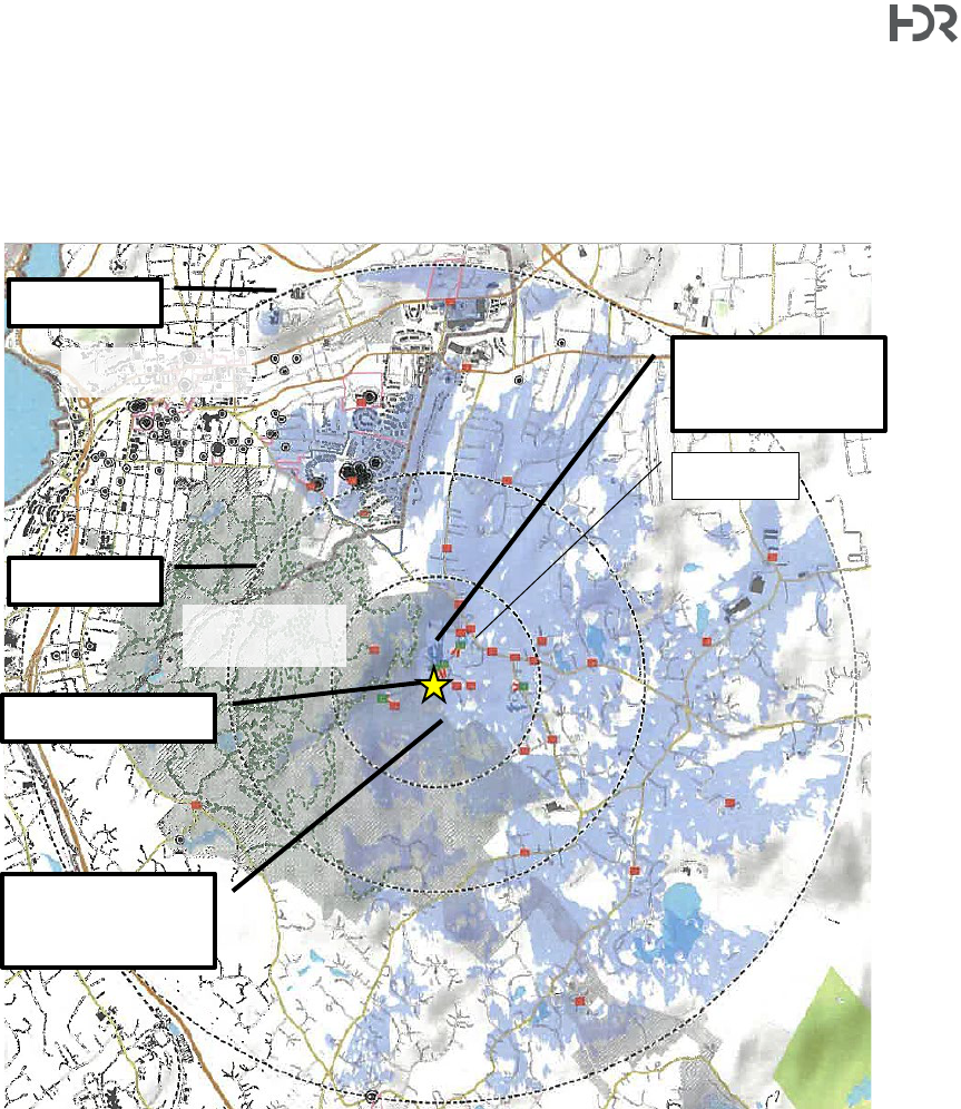
Town of Cortlandt|Homeland Towers / Verizon Wireless 52 Montrose Station Road New Tower – Tech Memo
1 International Boulevard, 10th Floor, Suite 1000, Mahwah, NJ 07495-0027
(201) 335-9300
hdrinc.com
21
visibility was checked during the balloon test on the viewshed map as confirmation – red squares
indicate the balloon was not visible (HDR confirmed this information during the July 2022 balloon
test), and green squares indicate the balloon was clearly visible. The locations shown on the figure
below are included in a table within the balloon test discussion below.
Viewshed Map. Source: Figure A1. Saratoga Associates VRA Report (dated August 18, 2022)
Annotation added by HDR for clarity. North oriented toward top of page. Inner ring = 0.5-mile radius; middle ring = 1.0-
mile radius, outer ring = 2.0-mile radius. Lighter blue shading indicates bare earth viewshed overlay, darker blue
shading indicates land cover based viewshed overlay (note: this is a substantially smaller total area and is difficult to
see on the small rendering above and is mostly centered within the 0.5-mile radius around the tower site).
Terrain in the vicinity of the proposed site is hilly with occasional steeply sloped topographical
features and is mostly suburban single family residential or open space (e.g., Blue Mountain
Reservation).
Proposed Tower Site
1-Mile Radius
2-Mile Radius
Visible based on bare
earth viewshed
analysis (lighter blue)
Visible based on land
cover viewshed
analysis (darker blue)
City of Peekskill
Blue Mountain
Reservation
Maple Ave.
Town of Cortlandt|Homeland Towers / Verizon Wireless 52 Montrose Station Road New Tower – Tech Memo
1 International Boulevard, 10th Floor, Suite 1000, Mahwah, NJ 07495-0027
(201) 335-9300
hdrinc.com
22
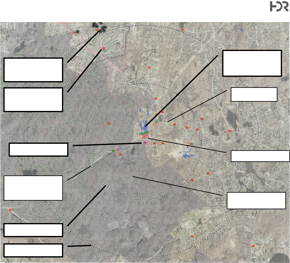
Viewshed Map. Source: Figure A2 (Land Cover Viewshed Overlay). Saratoga Associates VRA Report (dated August
18, 2022) Annotation added by HDR for clarity. North oriented toward top of page. Inner ring = 0.5-mile radius; outer
ring = 1.0-mile radius. Darker blue shading indicates land cover based viewshed overlay.
Based on the viewshed maps above, it appears that visual impacts resulting from the proposed
tower are most likely to occur within approximately 0.5 miles of the tower and limited to the gas
transmission right-of-way in Blue Mountain Reservation to the west; open spaces and residential
parcels to the north and in the immediate vicinity of the proposed tower, and open spaces along
Furnace Woods Road in the vicinity of the intersection with Galloway Lane. Viewpoints visited
during the balloon test are indicated above as color coded squares. Red indicates that the balloon
was not visible and green indicates that visibility was confirmed. Additional discussion on the
balloon test, photosimulations, and visual resources assessment is below; however, HDR notes
that the visibility predicted below was generally confirmed in the field by Saratoga as well as HDR
during the balloon test.
Balloon Test
A visibility test (“balloon test”) was conducted by Saratoga Associates to determine the visibility of
the proposed tower from various locations within up to approximately 2-miles of the proposed site.
Proposed Tower Site
0.5-mile Radius
1.0-mile Radius
Viewpoint (typ.)
visited in field during
balloon test.
National Register of
Historic Places Listed
or Eligible Site
Documented Blue
Mountain Reservation
Trail
Visible based on land
cover viewshed
analysis (darker blue)
Blue Mountain
Reservation
Montrose Station Rd.
Maple Avenue
Town of Cortlandt|Homeland Towers / Verizon Wireless 52 Montrose Station Road New Tower – Tech Memo
1 International Boulevard, 10th Floor, Suite 1000, Mahwah, NJ 07495-0027
(201) 335-9300
hdrinc.com
23
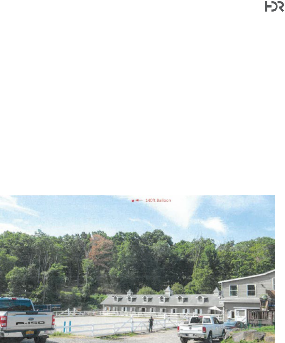
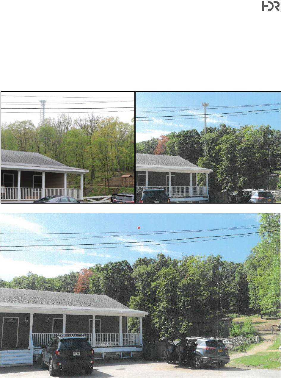
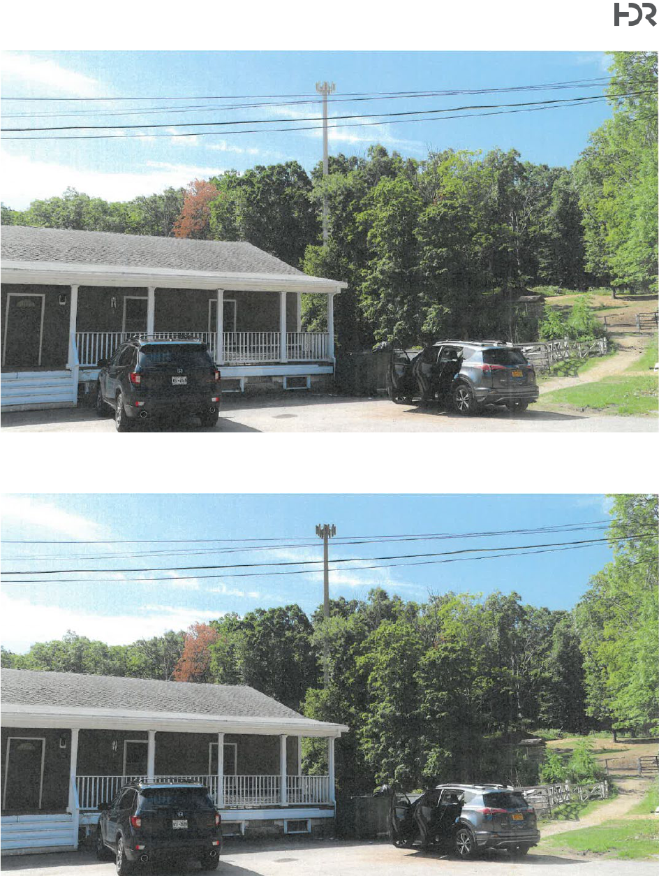
The balloon test consisted of flying a bright red colored ±4-ft diameter weather balloon at the
proposed tower location and height (140-ft). Once the balloon was confirmed to be at the
appropriate height, Saratoga field technicians drove to the 28 predetermined viewpoints to collect
photographs and document visibility.
HDR was also present in the field for the duration of the test and independently assessed visibility
from proposed viewpoints as well as other locations. HDR and Saratoga were in communication
during the field test. The test was conducted on Saturday July 23, 2022 with the balloon floated
between approximately 9:00 am and 1:25 pm. Winds were calm and sky conditions were clear for
the duration of the test.
Photographs were collected by Saratoga’s field technician from the nearest publicly accessible
vantage point at each location. Photographs were taken using a Canon EOS 6D Mark II DSLR 26-
MP camera with a lens setting of 50mm to simulate the human eye relative to scale. A total of 35
photographs were taken during the test at distances ranging from ±400 to ±9,600 feet from the
tower. The following photo is reproduced from the Saratoga VRA and depicts a typical photograph
in which the balloon in visible in the near field.
Photo 31. Taken near the dead end of Montrose Station Road in front of Blue Sky Stables.
Locations visited during the “leaf off” balloon test conducted in May 2019 for the original tower
location were also visited during the “leaf on” test conducted in July 2019. Saratoga notes in their
report that two locations visited both tests have the potential to be seasonally visible since the
balloon was visible during the “leaf off” test in May 2019 but not visible during the “leaf on” test in
July 2022. These locations are on Montrose Station Road near houses #32 and #36 and on Maple
Avenue near house #2117 (indicated as “**NO” in the table below). The following table is adapted
from “Table 1 – Key Observation Points” in the August 2022 Saratoga VRA report.
Town of Cortlandt|Homeland Towers / Verizon Wireless 52 Montrose Station Road New Tower – Tech Memo
1 International Boulevard, 10th Floor, Suite 1000, Mahwah, NJ 07495-0027
(201) 335-9300
hdrinc.com
24
Per NYSDEC’s Visual Policy, impacts are not intended to be assessed from areas that are not
accessible to the public; however, it is noted that some surrounding properties will have views of
the proposed tower.
Photo
#
Location Description
Direction
to
Tower
Distance
to
Tower
(feet)
Theoretical
View
Indicated by
Land Cover
Viewshed
Balloon
Visible
During
Field Test
Photo/
Simulation
Provided
1
Montrose Station Road near #32 and #36
W
430
NO
**NO
2
Montrose Station Road near #34
W
800
YES
NO
3
Montrose Station Road near #5
SSW
1,390
NO
NO
4
Montrose Station Road near #20
SSW
1,090
YES
YES
YES
5
Montrose Station Road near#26 and #39
S
500
YES
YES
YES
6
Montrose Station Road near#49 and #S7
SSE
410
YES
YES
YES
7
Blue Summit Reservation - Utility Road
ESE
1,260
NO
NO
8
Blue Mountain Reservation - Blue Mountain Summit
ESE
1,870
NO
NO
9
Montrose Station Road at Maple Avenue
SSW
2,070
NO
NO
10
Maple Avenue near #2117
SSW
1,610
YES
**NO
11
Maple Avenue near #2139
SW
1,570
NO
NO
12
Maple Avenue near Furnace Woods Road
WSW
2,020
YES
NO
13
Fairgreen Court at Maple Avenue
WSW
2,450
NO
NO
14
Furnace Woods Road near Galloway Lane
W
2,120
YES
YES
YES
15
Veronica Court near #10
NW
2,710
NO
NO
16
Veronica Court at Furnace Woods Road
WNW
3,170
NO
NO
17
Fairgreen Court at cul-de-sac
WSW
2,820
YES
NO
18
Hill and Dale Road at Maple Avenue
W
3,890
NO
NO
19
Rosalind Rd at Cross Road
W
6,850
YES
NO
20
Croton Avenue near #200
WSW
9,020
NO
NO
21
Dickerson Road at Hilltop Drive
WNW
7,910
NO
NO
22
Furnace Dock Road near #343
NW
6,790
NO
NO
23
Charles Cook Park
NNW
8,720
NO
NO
24
Watch Hill Road near Furnace Woods Elem. School
SSE
4,750
YES
NO
25
Montrose Station Road at Washington St
ENE
6,900
NO
NO
26
Lafayette Avenue near Damian Way
S
3,430
YES
NO
27
Greenlawn Road at Robbie Road
W
5,420
NO
NO
28
Chapel Hill Drive
SSE
5,570
NO
NO
29
1969 Crompond Rd. (NY Pres. Hudson Valley Hospital)
S
8,040
NO
NO
30
Blue Mountain Reservation - Utility Road at Gas ROW
ENE
1,510
YES
YES
YES
31
Montrose Station Road
S
440
YES
YES
YES
32
Main St at Dayton La (near Beecher-McFadden Estate)
S
9,650
YES
NO
33
Villa Loretto NR Site
SSE
7,370
NO
NO
34
Maple Avenue at Mount Florence NR Historic District
SSE
5,940
NO
NO
35
Underhill La (Mount Florence NR Historic District)
SSE
4,680
YES
NO
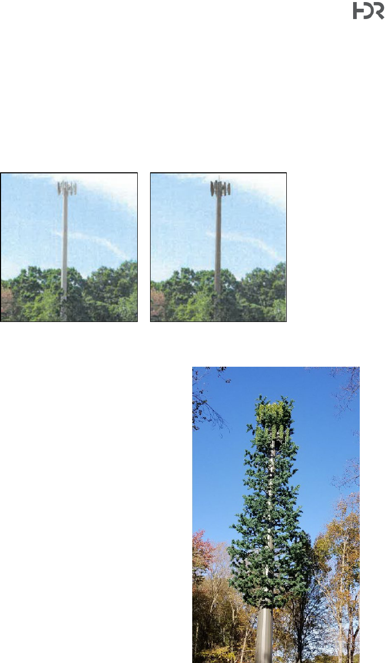
Saratoga prepared the photosimulations using a three-dimensional model of the proposed tower
developed in 3D Studio Max Design® software superimposed on the field photograph. The
process considers the field photograph’s location, elevation, direction, and time of day to simulate
the appearance of the tower from any given the viewpoint. Additional details on the methodology
employed are included in Saratoga’s report. At the request of HDR, Saratoga provided two
simulations of the tower – one using the proposed galvanized gray color and another using a matte
brown color. Photosimulations provide viewers with an approximate representation of potential
visual impacts from various locations at various distances and in consideration of other parameters
(e.g., partially obstructed, looking up, looking from a high point) within the survey area.
Town of Cortlandt|Homeland Towers / Verizon Wireless 52 Montrose Station Road New Tower – Tech Memo
1 International Boulevard, 10th Floor, Suite 1000, Mahwah, NJ 07495-0027
(201) 335-9300
hdrinc.com
25
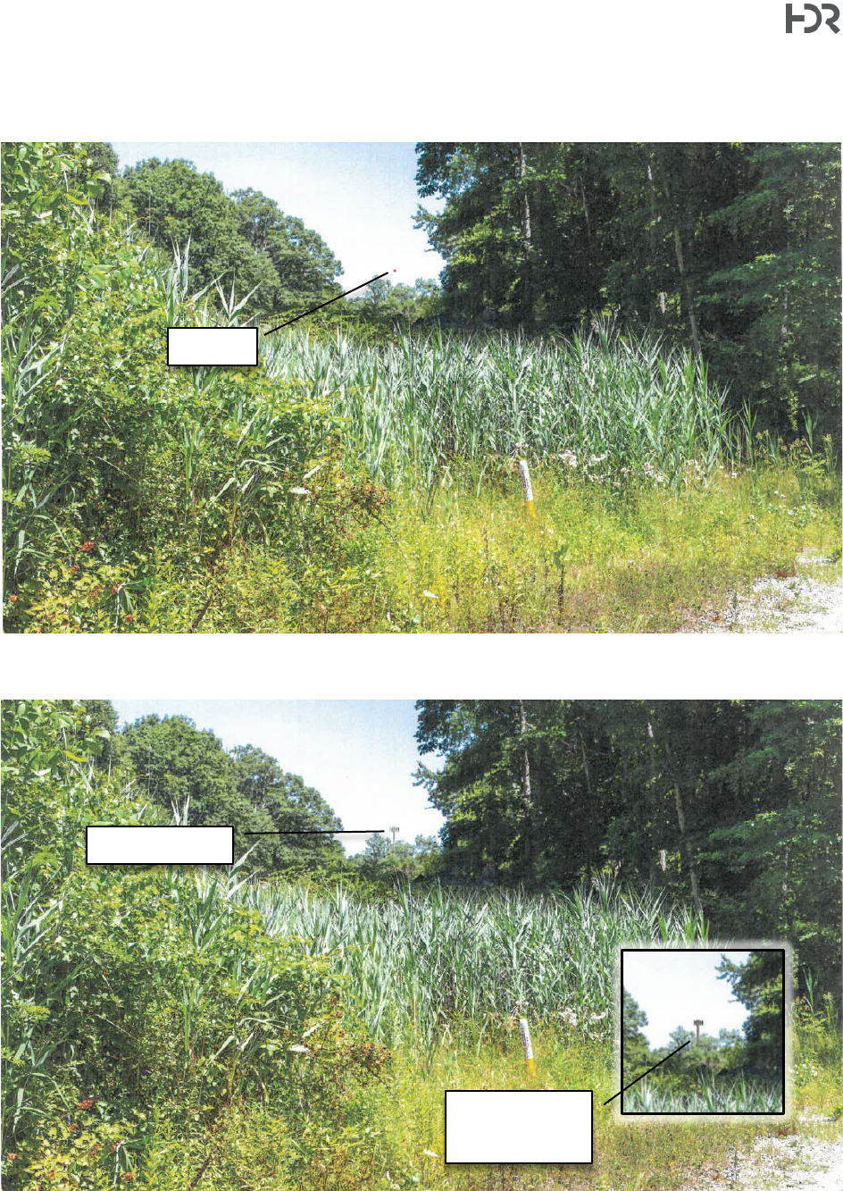
The following photos are reproduced from the VRAs (2019, 2022) to provide an example of a
simulation of the proposed tower from the near field. The photo (Photo #6) was taken from near
#49 and #57 Montrose Station Road approximately 410 feet from the proposed tower location.
The side-by-side comparison shows the former design (left; lattice tower at previous location and
elevation) and the current design (right; galvanized gray monopole) from a similar vantage point.
Figure C7 Saratoga VRA (2022) – Photo 6, balloon float field photo. Near #49 and #57 Montrose Station Road ±410-
ft from the tower.
Town of Cortlandt|Homeland Towers / Verizon Wireless 52 Montrose Station Road New Tower – Tech Memo
1 International Boulevard, 10th Floor, Suite 1000, Mahwah, NJ 07495-0027
(201) 335-9300
hdrinc.com
26
Figure C8 Saratoga VRA (2022) – Simulation of the proposed tower with a galvanized gray finish.
Figure C9 Saratoga VRA (2022) – Simulation of the proposed tower finished with a matte brown paint.
Town of Cortlandt|Homeland Towers / Verizon Wireless 52 Montrose Station Road New Tower – Tech Memo
1 International Boulevard, 10th Floor, Suite 1000, Mahwah, NJ 07495-0027
(201) 335-9300
hdrinc.com
27
HDR visited areas in addition to the predetermined locations to confirm visibility. HDR noted that
the balloon was visible at the intersection of a foot trail and a gas transmission main right of way
within Blue Mountain Reservation approximately 1,500 feet away.
Figure C13 Saratoga VRA (2022) – Photo 30, balloon float photo taken from a footpath crossing the gas transmission
main right of way in Blue Mountain Reservation approximately 1,500 feet from the proposed site.
Figure C14 Saratoga VRA (2022) – Simulation of the proposed tower with a galvanized gray finish.
Balloon
Simulated Tower
Inset shows brown
color option in
same setting.
Town of Cortlandt|Homeland Towers / Verizon Wireless 52 Montrose Station Road New Tower – Tech Memo
1 International Boulevard, 10th Floor, Suite 1000, Mahwah, NJ 07495-0027
(201) 335-9300
hdrinc.com
28
Additional photosimulations and the field photographs may be found in the Saratoga VRA.
Aesthetic Appearance of the Proposed Tower
As noted earlier in this Tech Memo, the original tower design has evolved over time based on
prior Town comments. The original design proposal called for a self-support lattice tower; the re-
design proposes a conventional monopole. The 2022 VRA includes photosimulations depicting
the conventional monopole in two colors – the proposed color (grey) as well as a matte brown
color.
Galvanized Gray
Matte Brown
Stealth Tree Consideration
HDR requested in its Memo #1 that the applicant
include photosimulations representing a stealth tree
design. It is understood that this type of design was not
originally considered; however, given that the proposed
location is in a generally wooded area, and it is in close
proximity to residents with direct views of the proposed
tower, it is recommended that the applicant provide
photosimulations depicting a stealth tree monopole for
the Town to consider as another option to potentially
limit visual impacts to the site area.
A well-designed stealth tree utilizing an appropriate
density of stealth branching and a tapering of the
branches from the base to the top of tower may be a
viable option for this location. If this option is carried
forward, the Town should also consider having a
detailed (and enforceable) maintenance plan a
condition of the approval.
The image of a stealth tree monopole constructed by
Homeland Towers at another site is incorporated herein
for reference only.
Example of a 120-ft tall Homeland Tower
stealth tree monopole design with two
arrays.

Town of Cortlandt|Homeland Towers / Verizon Wireless 52 Montrose Station Road New Tower – Tech Memo
1 International Boulevard, 10th Floor, Suite 1000, Mahwah, NJ 07495-0027
(201) 335-9300
hdrinc.com
29
Visual Resource Assessment (VRA)
Saratoga notes that it utilized New York State Department of Environmental Conservation’s
(NYSDEC) Program Policy on Assessing and Mitigating Visual Impact (“DEC Visual Policy”) to
guide the assessment and identification of areas that may have visual impacts from the proposed
tower. DEC’s Visual Policy provides a framework for the determination of visual significance and
impacts for the SEQRA process (on multiple project types, not solely telecommunications towers)
when DEC is the lead agency. However, it is advisory and commonly utilized by other lead
agencies for visual assessments. The policy provides a definition of what an aesthetically
significant place is (“A place that is formally designated and visited because of its beauty” – e.g.,
national or state parks, scenic roads, listed or eligible historic places, landmarks, state or federal
trails, etc.) and that the intent of the policy is to address places that are open and accessible to
the public (e.g., not private land).
The DEC Visual Policy offers that the limits of a visual assessment be determined on a case-by-
case basis. It recommends a 5-mile radius as a default search radius be used for the assessment
of visual impacts but also provides for both smaller and larger search areas depending on local
conditions and the nature of a given project.
The Saratoga VRA did not identify any nearby areas classified as a “scenic resource of statewide
significance” (e.g., national or state parks that attract tourists from long distances) citing that the
proposed site is largely screened by dense woodlands and terrain beyond an approximately 1-
mile radius from the site. The SEQR FEAF Part I completed by the applicant notes that the Taconic
State Parkway (a scenic highway) and Stony Point Battlefield (in Rockland County on the opposite
side of the Hudson River) are just within the 5-mile radius.
The following list provides the locations within 1-mile of the proposed site that were identified by
Saratoga as “aesthetic resources of local importance,” which reflects publicly accessible areas
that are important to the local community:
• Blue Mountain Reservation (immediately adjacent to the west) – Note: designated trailways
are included on the viewshed maps for reference.
o View of proposed tower observed – refer to note below.
• Briarcliff-Peekskill Trailway
o No views identified by Saratoga.
• City of Peekskill Parks – Depew Park
o No views identified by Saratoga
Saratoga concludes that visibility from the above aesthetic resources of local importance will not
have views of the proposed tower with the exception of a short segment of a trail within Blue
Mountain Reservation that intersects a gas transmission main right of way that is kept free of trees.
Additional areas of local interest were also identified by Saratoga at the request of the Town and
include nearby roadways, residential neighborhoods, and residential properties. Locations such

Town of Cortlandt|Homeland Towers / Verizon Wireless 52 Montrose Station Road New Tower – Tech Memo
1 International Boulevard, 10th Floor, Suite 1000, Mahwah, NJ 07495-0027
(201) 335-9300
hdrinc.com
30
as this are not explicitly included in the SEQRA determination and not required by the DEC Visual
Policy; however, they are important to the community and should be considered. The following
locations were identified:
• Residential Areas (particularly along Montrose Station Road)
• Roadways – approximately 16 miles of public roads within the 1-mile radius of the proposed
tower. The Saratoga report notes annual average daily traffic ranging between ±2,000
(Furnace Woods Road) and ±3,400 vehicles (vicinity of Blue Mountain Middle School).
o A gap in vegetation is noted (by Saratoga and as observed by HDR in the field
during the balloon test) along Furnace Woods Road at the intersection of Galloway
Lane provides a view of the proposed tower site. No other views were identified
from roadways.
Saratoga concludes that in most cases visibility from residential areas will be blocked by vegetation
even during winter, “leaf off” months and that visibility from local roads will be limited to occasional
views where gaps in roadside vegetation exist. These conclusions appear reasonable based on
HDR’s field observations and the results of the balloon visibility test. HDR notes that views from
parcels immediately adjacent to the proposed tower site (5 to 7 parcels) will not be blocked.
Based on HDR’s field observations and review of the materials submitted by the applicant in the
VRA, it is likely that visual impacts are limited to the immediate vicinity of the proposed tower.
Views of the proposed tower may exist from further distances (i.e., 2 to 5 miles); however, given
the terrain and elevation of the site HDR concurs that it is unlikely that there would be significant
aesthetic impacts to distant resources.
SEQRA and State Historic Preservation Office
The applicant has provided a Full Environmental Assessment Form (FEAF) Part I dated August
17, 2021 and an EAF Mapper Summary Report generated November 2, 2020. Email
correspondence included in the submittal also contained a copy of a SHPO correspondence noting
concurrence of no historic properties and no adverse effects on historic properties within the Area
of Potential Effect (APE). See Cultural/Ecological Resources section of this Tech Memo below for
additional information on cultural and ecological resources.
7. Co-Location Potential
The application filings and submitted construction drawings indicate that co-location by other
commercial wireless carriers is included in the design of the tower and ground-based equipment
compound (Verizon and two potential co-locators are noted). The applicant has noted in its filings
that an unnamed carrier has expressed interest and as such been included by way of generic
antenna configurations and ground equipment on the construction drawing set. Additionally, as
noted above, the alternate height analysis performed by C Squared, which modeled in-building
and in-vehicle signal propagation at various antenna centerline heights, shows that lower positions
on the proposed monopole may provide viable coverage footprints for other carriers.

Town of Cortlandt|Homeland Towers / Verizon Wireless 52 Montrose Station Road New Tower – Tech Memo
1 International Boulevard, 10th Floor, Suite 1000, Mahwah, NJ 07495-0027
(201) 335-9300
hdrinc.com
31
During the original application proceedings, the Town’s engineer requested documentation to be
provided that discussed co-location of emergency response equipment (e.g., Police/Fire/EMS) on
the tower. The applicant’s response included in its August 2021 responsive filing did not address
this specific issue and furthermore the structural certification letter prepared by the applicant’s
design engineer (SDG, dated August 5, 2021 and applicable to the re-designed tower) also did
not commit at that time to the number of co-locators the tower would be designed to accommodate.
Though the current design shows it can accommodate a total of three carriers, a recommendation
for clarification on the actual number intended to be accommodated and whether emergency
services equipment can be co-located is included at the end of this document.
The proposed tower design, as it is currently presented, meets the minimum requirements for co-
location set forth in Town Code §277-6.V based on the materials provided.
8. Cultural / Ecological Resources
Tree Removal
The applicant had performed a tree survey along the proposed access road and in the vicinity of
the proposed tower/compound and technician parking areas. A total of 19 trees were identified for
removal on Drawing Z12 of the 8-10-2022 construction drawings. The applicant indicates that
Drawing Z12 is a preliminary plan and that a final tree survey would be completed after the
preliminary site plan is approved by the Town.
During the original application process, the Town commissioned a tree survey to be done by
Bartlett Tree Experts (“Bartlett”). In a December 20, 2019 letter report, a total of 127 trees were
tagged. None of the trees surveyed met the Town’s protected species list or constitute a specimen
tree. The arborist notes that the stand is mostly an oak and maple stand with hickory and ash in
lower numbers. Protection of as many trees, especially the oaks, sugar maples, and hickories,
was recommended by the arborist.
It appears that compared to the original tree removal plan, which included 35 trees, that the
reconfigured the design reduces the amount of tree clearing required.
Cultural Resources
In its SEQR Full Environmental Assessment Form Part I (FEAF), the applicant indicated that the
site may be located within, adjacent to, or partially intersecting an area designated as sensitive for
archaeological sites on the New York State Historic Preservation Office (SHPO) site inventory. In
response to this question on the FEAF, the applicant included an email dated May 8, 2018 from
towernotifyinfo@fcc.gov that documents concurrence by the lead SHPO/THPO agency
(NYSHPO) that no historic properties fall within the area of potential effects (APE). Based on
information contained in the above referenced email, EnviroBusiness, Inc. (EBI) was the consulting
firm that filed the request on behalf of the applicant. HDR understands that an updated SHPO
determination is expected to be provided by the applicant based on the information provided in the
SDG letter dated August 10, 2022.

Town of Cortlandt|Homeland Towers / Verizon Wireless 52 Montrose Station Road New Tower – Tech Memo
1 International Boulevard, 10th Floor, Suite 1000, Mahwah, NJ 07495-0027
(201) 335-9300
hdrinc.com
32
The applicant noted in the FEAF (question E.3.h) that the proposed site is within 5 miles of an
officially designated and publicly accessible federal, state, or local scenic or aesthetic resource.
They list Stony Point Battlefield State Historic Site and the Taconic State Parkway.
No other cultural resources were noted by the applicant.
Ecological Resources
Per the FEAF submitted by the applicant, the proposed tower site is located in or adjoins a state
listed “Critical Environmental Area” (CEA). The EAF Mapper addendum identifies this as county
and state parklands of exceptional or unique character. It is known that the tower is proposed on
a residential parcel that abuts the Blue Mountain Reservation.
Though the EAF Mapper Addendum included by the applicant does not indicate threatened or
endangered species at the proposed site, the applicant has responded to FEAF question E.2.o
that US Fish and Wildlife Service (USFWS) indicates the project may affect the Northern Long
Eared Bat and/or Indiana Bat. If the application is approved, the applicants attest that they will
follow the recommended conservation measures prescribed by USFWS including limiting tree
removal to between October 1 and March 31.
The applicant states in its responses to FEAF question E.2.h that the project site does not contain
wetlands or other waterbodies and answers yes to E.2.h.i and E.2.h.ii which indicates that
wetlands or other waterbodies adjoin the site. In further details provided by the applicant, they
state that the nearest wetland or waterbody to the project site is Nelson Pond over 2,000 feet
away. HDR disagrees with this statement based on information available in NYSDEC’s
Environmental Mapper which depicts potential state-regulated freshwater wetlands and a small
pond approximately 500 feet from the site (the check zone extends into the proposed site). The
National Wetlands Inventory overlay included in the NYSDEC Environmental Mapper also shows
wetlands and water features in parcels adjacent to the site. The Town may need to confirm if an
additional approval is required based on the proximity of the wetland/pond (and check zone) to the
proposed facility.
Stormwater and Pollution Control
The applicant has stated in its filings that a Stormwater Pollution Prevention Plan (SWPPP) is not
required due to the proposed area of disturbance (±0.1986 acres) being less than the trigger value
of one acre. During the original application process, the Town Engineer requested that SWPPP
be provided regardless of the total area of disturbance given the (original) location’s impact to
steep slopes and creation of impervious surfaces. The applicant responded in its August 2021
filing that the re-designed and re-located tower no longer impacts steep slopes and reasserts its
position that a SWPPP is not required. A recommendation is included at the end of this document
for the Planning Board to confirm whether a SWPPP is needed and/or whether Major Grading
and/or Steep Slopes permits are required.

Town of Cortlandt|Homeland Towers / Verizon Wireless 52 Montrose Station Road New Tower – Tech Memo
1 International Boulevard, 10th Floor, Suite 1000, Mahwah, NJ 07495-0027
(201) 335-9300
hdrinc.com
33
9. Structural Assessment
A full structural and foundation analysis was not provided as part of the initial filings submitted by
the applicants as additional information is still required (e.g., geotechnical data, final tower type,
an approved location). The final tower type will affect the structural design of the tower and its
foundation. A Structural Certification Letter was submitted with the original application filings in
August 2021. The letter, which was prepared by Scherer Design Group LLC, a NYS P.E. and
dated August 5, 2021 states that the proposed tower and its foundation as well as all attachments
will be designed to meet ANSI/TIA-222-H in conjunction with county, state, and federal
requirements for loading (including ice and wind loads). It will also be designed with a hinge/break
point at 84-ft above grade such that in the unlikely event of structural failure the upper portion of
the tower would remain within the property.
The final configuration of the monopole, if approved, will be based on Planning Board input and
conditions that may possibly influence the cell site’s appearance and structural design. Thus, a
final analysis should be required as a condition of approval, during the Building Permit
phase of the project. It is understood that the applicant maintains full responsibility for the
accuracy and adequacy of all aspects of the proposed installation, design, and
construction of the tower, if approved. It is also understood that the Town’s Department of
Technical Services may conduct a detailed review of the structural analysis, including all design
assumptions and calculations, if the Site Plan and Special Use Permit are approved.
10. Summary of Technical Review Findings and Recommendations
Findings
• The responses to comments and additional information provided by the applicants appear
to be responsive, and the combined application materials / filings appear to be
comprehensive and in accordance with the requirements of the Town’s Wireless Code
(Chapter 277 of Town of Cortlandt Code) except as noted below:
o §277-6E(1)(q): The applicant has not provided its “proposed tower maintenance
and inspection procedures and related system of records” beyond a note on
drawing Z4 saying that the tower will be monitored remotely and visited monthly by
a technician. Additional information (maintenance plan and checklists) can be
furnished as a condition (should the site plan and special use permit approvals be
granted by the Planning Board).
o §277-6E(1)(u): Certification that a topographic and geomorphologic study and
analysis has not been conducted. The applicant has requested to complete this
effort subsequent to necessary approvals being issued (i.e., at the Building Permit
phase of the project), which appears to be reasonable.

Town of Cortlandt|Homeland Towers / Verizon Wireless 52 Montrose Station Road New Tower – Tech Memo
1 International Boulevard, 10th Floor, Suite 1000, Mahwah, NJ 07495-0027
(201) 335-9300
hdrinc.com
34
• As depicted in the application materials and described in this Tech Memo, Verizon’s need
to remedy a service gap appears to have been adequately documented. HDR concurs with
the applicant’s site selection analysis in that there appears to be no other tall structures or
towers in the search area that could be utilized in lieu of a new facility/tower structure that
would meet the priority siting requirements of the Town Code (§277-7) and achieve the
applicant’s stated objectives. A telecommunications facility consisting of a new tower
located at the Montrose Station Road site, as proposed, will provide enhanced Verizon
network services to the gap area.
• The proposed tower’s re-design (from lattice tower to monopole) resulted in the following
major changes:
o Change in tower style from self-support lattice tower to conventional monopole.
o Reduction in tower elevation by approximately 35-ft (ground elevation at the original
tower base was ±445-ft amsl and at the new tower location is ±410-ft amsl) .
o Reduction in footprint of equipment compound from 1,425 square feet to 930
square feet. Tower now located within compound.
o Reduction in proposed quantity of trees to remove (from 35 to 19).
o Tower moved farther from side yard lot line to avoid need for variance and includes
break point at 84-ft agl on tower.
• The location of the proposed monopole at 52 Montrose Station Road appears reasonable
based on (a) the areas of documented service needs (i.e., around the site area; Blue
Mountain Reservation, south of the site near Blue Mountain Middle School and Furnace
Woods Elementary, nearby neighborhood communities) (b) achieved setbacks (e.g.,
property line requirements, fall-zone); (c) the findings of the alternate site analysis
conducted; and (d) the predicted coverage and interaction with existing “on air” Verizon
cell sites in the area.
The proposed site at 52 Montrose Station Road is well-positioned to
interact with nearby existing Verizon sites and is at appropriate distances from those
facilities and at a focused height to serve the site area and provide the necessary service
objectives for Verizon’s local wireless network.
• The height of the proposed monopole (140 ft above grade) appears to be reasonable based
on (a) the heights of existing trees and the varying topography that exists in the area which
could impede signal propagation; (b) the possibility of future co-location by other wireless
carriers or Town antennas should the tower be approved and constructed; (c) the fact that
FAA markings or lighting will not be required at the proposed height; and (d) Town Code
Section 277-9(B) states that
towers shall not exceed 140 ft in height. The 140 ft height
appears to balance the needs of the applicant while providing usable space at lower
heights for co-location in the future. As noted above, the re-design has moved the tower
location to a ground elevation that is approximately 35-ft lower than that of the initial design.
• In the FEAF provided by the applicant it is noted that the estimated average depth to
bedrock at the site is 2.5-feet. Furthermore, portions of the proposed compound and

Town of Cortlandt|Homeland Towers / Verizon Wireless 52 Montrose Station Road New Tower – Tech Memo
1 International Boulevard, 10th Floor, Suite 1000, Mahwah, NJ 07495-0027
(201) 335-9300
hdrinc.com
35
access drive shown on sheet Z3 overlap with areas identified as rock outcrops on the
applicant’s survey shown on sheet Z11. Rock removal plans and/or blasting plans have
not been noted by the applicant. Final means and methods for foundation work, grading,
and other construction will be provided during the building permit process should the
project obtain the necessary approvals from the Planning Board.
• At present, an unnamed carrier has expressed interest in co-locating at the proposed site,
if approved and constructed, Preliminary tower-based equipment configurations and
ground equipment plans were included in the application for a second provider (below
Verizon on the monopole elevation view). Regarding future co-location by others - if the
tower is approved and constructed, it is noted that any other carrier (besides Verizon)
would need to apply – at a minimum – for a separate building permit from the Town. Future
co-location should not need to propose substantial changes (per FCC Eligible Facilities
Request [EFR] criteria) to the monopole site; however, if substantial changes are proposed
in the future (e.g., height increase of greater than 20 ft; significant expansion of the ground-
based equipment area) a new Special Use Permit and Site Plan review may be required.
• In order to comply with the applicable FCC general public MPE criteria, RF levels were
calculated for the proposed Verizon installation and with assumptions of three additional
carriers (including AT&T, T-Mobile, and DISH). The anticipated RF levels were
conservatively modeled and show that emissions will be compliant with the general public
MPE criteria at locations in proximity to the site.
No FAA tower lighting or marking appears to be required for the proposed tower. An
updated FAA “Determination of No Hazard to Air Navigation” statement should be provided
as a condition if the Planning Board approvals are issued.
• The structural design of the tower will include a hinge-point (i.e., at 84-ft above grade, 56-
ft below the top of the tower) such that in the event of a catastrophic failure the tower should
remain within the subject property. A final tower and foundation analysis will be required
as a condition of approvals, as those analyses can only be finalized after decisions
regarding the monopole design and location are approved under the Site Plan.
• The applicant has not identified the need for zoning variances based on the re-design of
the tower. The original tower design was closer to the property line and did not include a
break-point to control where the structure would land in a failure scenario. It is understood
that the Town will confirm if any additional approvals are required (such as might relate to
the proximity of wetlands/ponds and check zones).

Town of Cortlandt|Homeland Towers / Verizon Wireless 52 Montrose Station Road New Tower – Tech Memo
1 International Boulevard, 10th Floor, Suite 1000, Mahwah, NJ 07495-0027
(201) 335-9300
hdrinc.com
36
Recommendations
The following recommendations are identified based on HDR’s technical review of the application
materials. Some of the below recommendations may be considered as conditions if the Site Plan
and Special Use Permit application are approved.
• Monopole and Equipment Compound Configuration:
Tower Design: It is understood that final tower design, colors, textures, and other aesthetic
aspects of all proposed equipment including but not limited to the tower, pole / tower color,
ground-based equipment compound and fencing, and landscaping are subject to Planning
Board review and approval.
HDR recommends that the applicant provide photosimulations of a stealth tree design
for the Planning Board’s consideration. These simulations should also include the total
number of potential antenna arrays that the tower is designed to accommodate. It is suggested
that the simulations be performed on photo numbers 4, 6, 30, and 31 to provide a number of
conceptual views of this style tower.
For reference and comparison to the proposed conventional monopole design, a stealth tree
design – with Verizon and potential co-location – should be added as a new cross-
section image in the Drawing set (allowing side-by-side comparison).
Regardless of the final tower design selected, measures should be included to address any
damage to paint or coating that occurs during shipping or installation. For a stealth tree option,
any visible portions of tower-mounted equipment should be color matched and/or camouflaged
using RF-transparent antenna socks (e.g., to blend in with stealth tree limbs). It is understood
that cables (for Verizon and any future co-locators) connecting equipment mounted on the
monopole with ground-based equipment will be routed within the monopole structure.
• Zoning Variances: The applicant has not indicated the need for any zoning variances with the
current tower design; however, variance needs will be determined by the Town.
• SEQRA and Cultural Resources: Based on the final tower configuration and Site Plan
conditions, the Full EAF (Part 2) should be finalized by the Planning Board. Based on the
review of applicant submittals and proposed disturbance for construction, there do not appear
to be constraints associated with wetlands, cultural, or ecological resources except as required
to protect threatened and endangers species. Construction work (including tree removal)
should follow the NYSDEC recommendations considering potential presence of protected bat
species. HDR understands that an updated SHPO determination will be provided based on
information provided in the SDG letter dated August 10, 2022.

Town of Cortlandt|Homeland Towers / Verizon Wireless 52 Montrose Station Road New Tower – Tech Memo
1 International Boulevard, 10th Floor, Suite 1000, Mahwah, NJ 07495-0027
(201) 335-9300
hdrinc.com
37
• Wireless Carrier and Town / Emergency Services antenna co-location: The applicant shall
confirm, in writing, the total number of antenna arrays (inclusive of their own) that the final
tower design will be able to accommodate. The most recent structural certification letter
prepared by the applicant’s design engineer, dated August 5, 2021 vaguely states that “the
tower will be designed to support additional co-locators.” The 8-10-2022 construction drawings
provided depict a total of three ground-based equipment pads implying a total of three. The
most recent NIER report prepared by Pinnacle Telecom group includes an assumption for four
carriers.
Furthermore, the applicant shall include in this response, whether Town and/or emergency
services equipment will be able to be co-located upon the tower, should the Town be
interested. If there is Town interest in utilizing the tower, details on antenna(s) and equipment
proposed will need to be provided to the applicant. HDR understands that plans by the Town
for co-locating on the tower can be resolved during the Building Permit phase of the project.
• Structural and Foundation Analysis: If approved, the tower will be designed to
accommodate up to three commercial wireless carriers (Verizon and two others) below the
proposed Verizon antennas. [See above comment on Town/emergency services antennas.]
It is recommended that a final structural and foundation design analysis be developed as a
condition of approval to include the final approved tower configuration and co-location
scenarios, including design for co-location by three other commercial carriers and Town-owned
/ emergency services antennas. These analyses can be performed at the Building Permit
phase of the project (i.e., after the tower design and style is finalized with the Planning Board).
All data that supports the final structural and foundation analyses, such as soil borings, shall
be provided to the Building Department / Department of Technical Services. It is understood
that the Applicant and the Applicant’s engineer maintain full responsibility for the
accuracy and adequacy of all aspects of the design and structural analyses, and for the
construction and maintenance/operation of the Verizon/Homeland facility.
o It is understood that if any height extension above 140 ft is proposed for the monopole
in the future, appropriate Town of Cortlandt Code provisions must be adhered to. A
height extension proposal may also require a new / separate FAA notification and
request for determination (along with Planning Board review if FCC EFR criteria are
not met). HDR believes that the proposed monopole site / tower height is designed to
be adequate to allow co-location by other carriers that service the area. Any
modification to a wireless facility in the Town must first be approved by the Building
Department (in the case of modifications, upgrades, and co-locations that do not
constitute FCC substantial changes) and/or the Planning Board (if an FCC substantial
change is proposed).
• Construction: If the tower is approved, a proposed construction schedule should be provided
by the applicant at the Building Permit stage of the project. A description of site
preparation/clearing activities, demolition of existing structures, work hours and duration of
work, soil erosion/sediment controls, and proposed construction equipment (e.g., crane,

Town of Cortlandt|Homeland Towers / Verizon Wireless 52 Montrose Station Road New Tower – Tech Memo
1 International Boulevard, 10th Floor, Suite 1000, Mahwah, NJ 07495-0027
(201) 335-9300
hdrinc.com
38
grading equipment) should be submitted to the Department of Technical Services including the
final construction drawing set and any other details requested that have not already been
provided and/or if any revisions become necessary. The Planning Board Engineer will confirm
is additional information (e.g., filing of SWPPP is necessary).
The applicant should confirm that the access driveway will meet the requirements for
emergency vehicle access and vehicle carrying capacity (e.g., for fire apparatus).
During the Building Permit phase of the project, it is understood that aspects of the design
should be referred to the Town of Cortlandt for their comments on items including, but not
limited to, generator specification, fire suppression needs, and site access drive configuration.
If it is determined during the proposed geotechnical investigation that blasting is necessary to
accommodate removal of rock, a blasting plan and permit approval may also be required.
If the application is approved, the tree removal plan shown on Sheet Z12 must be adhered to.
The Town may consult with its arborist and confirm the proposed trees to be removed. Any
trees that are identified that require protection during construction activities shall be protected.
Damage to any trees not marked for removal during construction is not permitted and shall be
reported to the Town.
Construction may only occur after approvals of the Site Plan, Special Use Permit, zoning
variances (if determined to be required), Major Grading permit (if determined to be required),
Steep Slopes permit (if determined to be required), and any other permits/approvals deemed
required by the Town or other governing body (e.g., Westchester County or New York State)
be secured.
“As Built” drawings should be submitted after construction and include the following information
– along with any additional items required by the Department of Technical Services:
o Documentation/survey of actual tower height and location.
o Actual centerline height of the Verizon antenna array.
o Map of all trenches, utility runs, and utility connections associated with the facility.
o Documentation that antennas, transformer and all other equipment is properly grounded
and bonded and in compliance with all applicable electrical and fire codes.
It is assumed that excess soil removed during construction / grading operations will be
maintained on-site. Should any soil need to be transported off-site, it is the applicant’s
responsibility to comply with all local, State, and Federal regulations pertaining to soil
characterization, transportation, disposal, and reuse. Groundwater (if encountered during
foundation work) should be handled in accordance with all appropriate rules and regulations.
• Operations (future): Operations shall be maintained in accordance with the Town’s Wireless
Code and all other relevant Town code sections and State/Federal requirements (including
non-interference compliance). Any proposed modifications to Verizon’s number of antennas,
antenna sizes, operating frequencies (i.e., addition of high-frequency 5G services), or

Town of Cortlandt|Homeland Towers / Verizon Wireless 52 Montrose Station Road New Tower – Tech Memo
1 International Boulevard, 10th Floor, Suite 1000, Mahwah, NJ 07495-0027
(201) 335-9300
hdrinc.com
39
number/sizes of other equipment from the information as provided in the application materials
and as noted on the final Planning Board Drawing Set shall first be approved by the Town prior
to any modifications. All necessary Town approvals must be obtained before any modifications
are conducted. Co-location that may be contemplated at the site must first be approved by the
Town. See above notes under Structural and Foundation Analysis as related to co-location
scenarios and FCC substantial change criteria.
• Generator: The periodic testing of the generator shall occur at a maximum frequency of 1 day
per week or every other week for a maximum of 15 to 30 minutes during weekday business
hours only. The sound attenuating enclosure and intrinsic secondary fuel containment shall be
included as part of the generator. It is the applicant’s responsibility to comply with all
appropriate NYSDEC regulations with regards to the operations of the generator.
• Maintenance: If the application is approved, a site-specific maintenance checklist should be
provided by the applicant at the Building Permit stage of the project. Periodic inspection and
maintenance should target upkeep of the visible aspects of the wireless facility in accordance
with the approved Site Plan and/or “as-builts” that are developed. Integrity of the tower exterior
surface and the appearance of all ancillary equipment should be adequately maintained in
accordance with the approved Site Plan. Industrial coatings are recommended for painting of
the monopole, antennas, and all exterior equipment that is visible to the public.
• RF / Safety: The proposed FCC-type and notification signage should be installed and routinely
inspected and maintained at all times in accordance with all FCC rules, regulations, and
guidance. It is the applicant’s sole responsibility to comply with all FCC rules and regulations
that are applicable to the site and operations, including but not limited to compliance with RF
emission levels and non-interference parameters. Signage with facility contact information
(Verizon and Homeland) shall also be installed and maintained at the site at all times. The
same shall applies to any future co-locators.
• Per Town Wireless Code §277-12, a sign no larger than four square feet indicating
the presence of an antenna that has transmission capabilities in the immediate
area shall be posted. The sign shall contain the name of the facility owner(s) and
operator(s) of the antenna(s) as well as emergency contact number shall be visible
from the access point of the site.
o Note: Signage shall be maintained and updated as needed.
• No commercial advertising is permitted.
• Contact information representatives of Verizon, Homeland, and any future co-
locator(s) shall be on file and kept up to date at all times with the Town.
• In the event that the cell site is built, and ownership is divested to another
company, signage and contact information shall be updated.
• EAF: The version and date of the latest EAF should be confirmed by the applicant and an
updated EAF submitted if the August 17, 2021 EAF is not the current, most up to date EAF.
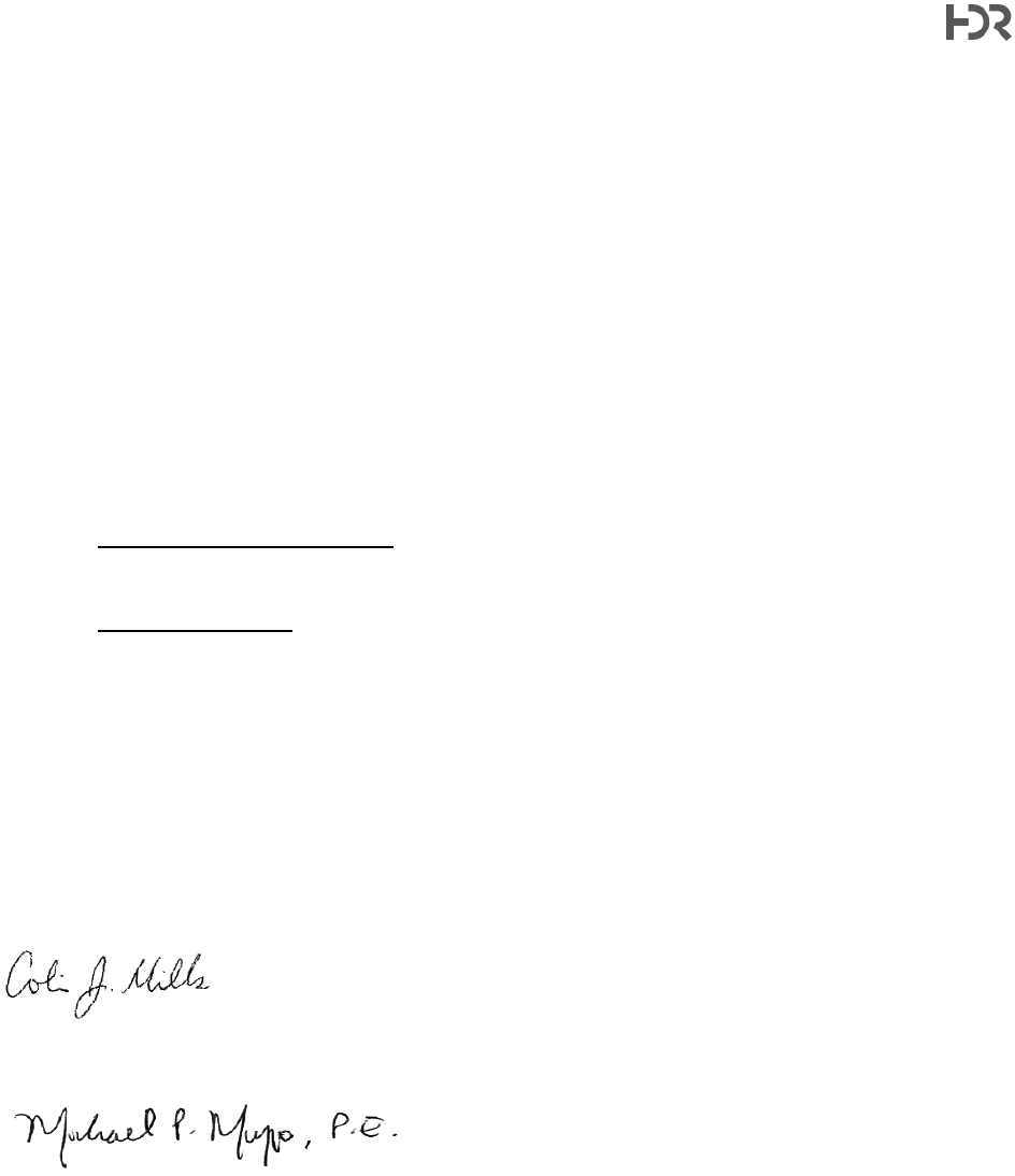
Town of Cortlandt|Homeland Towers / Verizon Wireless 52 Montrose Station Road New Tower – Tech Memo
1 International Boulevard, 10th Floor, Suite 1000, Mahwah, NJ 07495-0027
(201) 335-9300
hdrinc.com
40
• Other:
• If the Special Use Permit and Site Plan are approved for this Verizon/Homeland
application, construction shall not be initiated until all approval conditions are met to the
satisfaction of the Planning Board, Planning Board attorney, Planning Board consultants,
and the Department of Technical Services. It is anticipated that a “Check Set” version of
final Construction Drawings – and any other supplemental materials to document final
Planning Board decisions and the Site Plan and Special Use Permit conditions - will be
submitted for Planning Board Chairperson signature prior to the Building Permit phase
of the project.
• All applicable Town Code sections (including but not limited to Wireless Code, Chapter
277) and other state/federal requirements relating to operations, periodic compliance
reporting, certifications, permit renewals, and other items shall be adhered to by the
applicant (or tower owner if ownership is transferred in the future) for the life of the facility.
• Performance/Removal Bond. Performance bond or other security will be furnished by the
applicant, in accordance with Town Wireless Code §277-21. The need for a construction
/ completion bond should be reviewed by the Planning Board attorney.
• Fees and Escrows. The Planning Board should review the applicant’s fees and escrows
to verify they are adequate before full approvals are granted.
Please feel free to contact us should you have any questions on this memorandum.
Sincerely,
Henningson, Durham & Richardson
Architecture and Engineering, P.C.
in association with HDR Engineering Inc.
Colin Mills
Project Scientist
Michael P. Musso, P.E.
Senior Project Manager
