1
WISCONSIN DEPARTMENT OF NATURAL RESOURCES
Trout Stream Management And Status Report Of
The West Branch Sugar River Watershed
Dane County, Wisconsin 2020-2021
Dan Oele
Fisheries Biologist for Dane, Green, Rock Counties
Wisconsin Department of Natural Resources
Fitchburg, Wisconsin
2022
2
Table of Contents
Executive Summary…………………………………………………………………………………………………………3
Introduction.……………………………………………………………………………………………………………………6
Methods……..……………………………………………………………………………………………………………………7
Results……….……………………………………………………………………………………………………………………9
Discussion.…………………………………………………………………………………………………………………..…11
Management Recommendations…………………………………………………………………………………..13
Tables…………………………………………………………………………………………………………………………….15
Figures……………………………………………………………………………………………………………………………22
3
Executive Summary
The West Branch Sugar River watershed is located west and south of Verona and
contains nine trout streams. The West Branch Sugar River is a Class 2 trout stream
and has been routinely stocked with brook trout. Mount Vernon Creek is Class 1 and
is not regularly stocked, except for occasional adult brook trout. Deer Creek, Flynn
Creek, Fryes Feeder and Primrose Branch are Class 2 trout waters and have been
stocked recently with brook trout.
We sampled trout streams in the West Branch Sugar River watershed using single-
pass stream electrofishing following the suspension of stocking to assess natural
recruitment and natural reproduction. We found fishable populations, evidence of
excellent recruitment and moderate to high abundances of trout throughout the
watershed. We documented abundant brown trout and high natural recruitment in
Flynn Creek, Primrose Branch and Mount Vernon Creek, while the West Branch Sugar
River had lower recruitment and reduced adult populations. Fryes Feeder, Flynn
Creek, Primrose Branch and unnamed WBIC 887300 are healthy, self-sustaining brook
trout fisheries. Deer Creek is a mixed fishery with modest abundances of brook and
brown trout. Milum Creek and its tributary (unnamed waterbody identification code
[hereafter, WBIC] 7215113) contain brook trout but in very low abundances. Unnamed
WBIC 5036972 and unnamed WBIC 886700 have modest abundances of trout.
Mount Vernon Creek is appropriately classified as Class 1 trout waters, and many of
the streams we surveyed will be proposed for changes during the 2024
reclassification cycle. Currently, Class 2 trout waters of Deer Creek, Fryes Feeder,
Flynn Creek, Primrose Branch and the West Branch Sugar River should be upgraded
to Class 1 trout waters while the unnamed tributary to West Branch Sugar (WBIC
887300), unnamed tributary to Mount Vernon Creek (WBIC 886700) and the unnamed
tributary to Fryes Feeder (WBIC 5036792) should be upgraded from unclassified to
Class 1 trout waters.
A major threat to high-quality brook trout fisheries detailed in this report includes
the steady increase of brown trout populations in streams managed for brook trout.
In the early 2000s, it was rare to find a brown trout in Deer Creek, but our most recent
survey in 2022 showed brown trout outnumbering brook trout in these streams by a
wide margin. Without drastic interventions, we should expect similar patterns in
southern Wisconsin brook trout populations as climate change results in trout
streams becoming more conducive to brown trout and less so for brook trout. Once
brown trout have displaced brook trout in small streams like Deer Creek, Primrose
Branch and small unnamed tributaries, stocking is not expected to help brook trout
regain dominance.

4
Management recommendations outlined in this report include: maintaining high-
quality recreational fishing opportunities in Mount Vernon Creek, increasing adult
trout abundances in West Branch Sugar River by investing in Trout Stamp habitat
improvement projects, evaluating angler-use and harvest within the watershed using
angler creel surveys, continuing targeted DNR Stream Bank Easement Outreach
activities and evaluating Mount Vernon Creek special regulation in the lower reach.
ACKNOWLEDGEMENTS
Data collection for the 2020 and 2021 surveys were completed by DNR staff Andrew
Notbohm, Jim Amrhein, Camille Bruhn, Kim Kuber, Samantha Brose, David Rowe and
Dan Oele. Bryce Linden contributed watershed maps. Claire Gaber, David Rowe and
Tim Simonson provided feedback and edits for this report.
Questions or comments about this report? Please contact the author at: (608) 419-
3272 or [email protected]
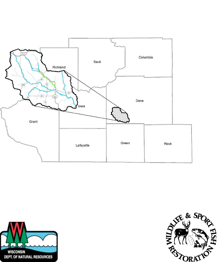
WATERSHED LOCATION
West Branch Sugar River Watershed, Dane County including West Branch Sugar River,
Mount Vernon Creek, Deer Creek, Fryes Feeder, Flynn Creek, Milum Creek, unnamed
tributary to Milum, Primrose Branch, unnamed tributary to Mount Vernon Creek,
unnamed tributary to West Branch Sugar River and an unnamed tributary to Fryes
Feeder.
PURPOSE OF SURVEY
DNR baseline trout rotation and trout potential surveys
Assess trout stream classification
Assess natural reproduction and recruitment
Assess current trout population abundance
DATES OF FIELDWORK
July 28, 2020 – Sept. 18, 2020 (Flynn Creek, Fryes Feeder, Milum Creek, unnamed
tributary to Fryes Feeder, unnamed tributary to Mount Vernon, unnamed tributary to
West Branch Sugar River)
June 22, 2021 – Aug. 5, 2021 (Deer Creek, West Branch Sugar River, Mount Vernon
Creek, Primrose Branch, unnamed tributary to Milum Creek)
FISH SPECIES OBSERVED IN THE SURVEY
All fish encountered were collected and recorded including American brook lamprey,
brook stickleback, brook trout, brown trout, central mudminnow, common carp, creek
chub, green sunfish, johnny darter, largemouth bass, mottled sculpin, white sucker
and yellow bullhead.

5
Introduction
SUMMARY OF THE WATERSHED
The West Branch Sugar River originates west of the town of Mount Horeb and flows
southeast, where it joins the Sugar River upstream of the dam in Belleville. The entire
stretch is Class 2 trout waters. Mount Vernon Creek is a large, Class 1 tributary of the
West Branch and is formed by the junction of Deer Creek and Fryes Feeder in the
town of Springdale. Deer Creek (Class 2) forms the western tributary of Mount Vernon
and runs along HWY 92 towards Mount Horeb, while Fryes Feeder (Class 2) flows
southerly along Town Hall Road. Flynn Creek (Class 2) crosses Fritz Road and flows
south to meet the West Branch in the town of Montrose. Primrose Branch flows
easterly from its headwaters along HWY G until it meets the West Branch Sugar River
between HWY U and HWY A. Several unclassified streams were surveyed as trout
potential streams in this rotation, including Milum Creek and its unnamed tributary
(WBIC 7215113), a spring pond tributary to Fryes Feeder (unnamed WBIC 5036972), an
unnamed tributary to the West Branch Sugar River (joins West Branch downstream of
HWY G) and an unnamed tributary to Mount Vernon (unnamed WBIC 886700) which
runs along Spring Rose Road and crosses HWY 92.
Deer Creek, Flynn Creek, Fryes Feeder, Milum Creek are designated DNR Exceptional
Resource Waters, and Mount Vernon Creek is a designated Outstanding Resource
Water which indicates these rivers provide outstanding recreational opportunities,
support valuable fisheries and wildlife habitat and have good water quality.
The West Branch Sugar River watershed covers 66.74 square miles, and land use in
the watershed is primarily agricultural (39.90%), grassland (33.80%) and a mix of
forest (19.70%) and other uses (6.60%). This watershed has 1,567 stream miles, 10 lake
acres and 1,132 wetland acres.
CURRENT STATUS AND MANAGEMENT HISTORY
Class 1 trout streams are those with high-quality habitat with sufficient levels of
natural reproduction to sustain the fishery, and no stocking is required. Class 2
streams are those in which some natural reproduction occurs but not enough to
utilize all available food and space, and stocking is required to maintain a desirable
fishery. Class 3 streams are those in which trout habitat is marginal with no natural
reproduction occurring and requires stocking of catchable-sized trout to provide a
fishing opportunity. Mount Vernon Creek is the only Class 1 trout steam in this
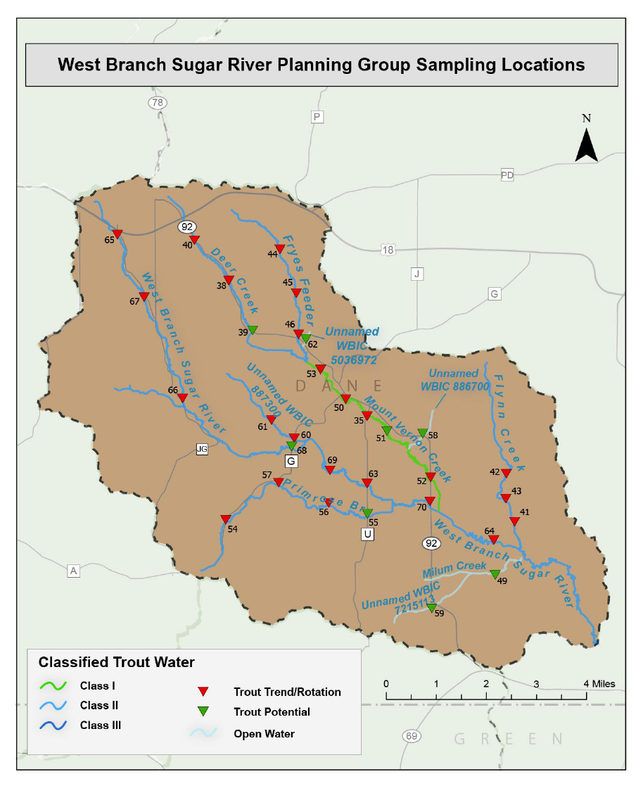
watershed, and all others are Class 2 or unclassified (Figure 1).
In 2015 it was decided to discontinue brown trout stocking in the watershed to
promote brook trout and prevent competition between stocked brown and brook
trout. The West Branch Sugar River was stocked with brown trout from 2003-2015, and
6
Primrose Branch was stocked with brown trout in 2003. Regular brook trout stocking
has occurred in Deer Creek, Flynn Creek and Fryes Feeder (Table 1).
The Wisconsin Department of Natural Resources (DNR), Dane County and
conservation organizations like the Southern Wisconsin Chapter of Trout Unlimited
have long been active in acquiring easements and conducting habitat improvement
projects in the watershed. For example, long stretches of Mount Vernon Creek, the
West Branch Sugar River and Primrose Branch have had habitat improvement
projects completed along publicly accessible lands. However, these projects were
conducted in the early 2000s or later, and some of the structures have since
degraded (e.g., wood additions no longer present, LUNKERS tipping over or filled in).
Additionally, many of these streams could benefit from bank sloping to reconnect the
floodplain and improve angler access as the stream has incised over time.
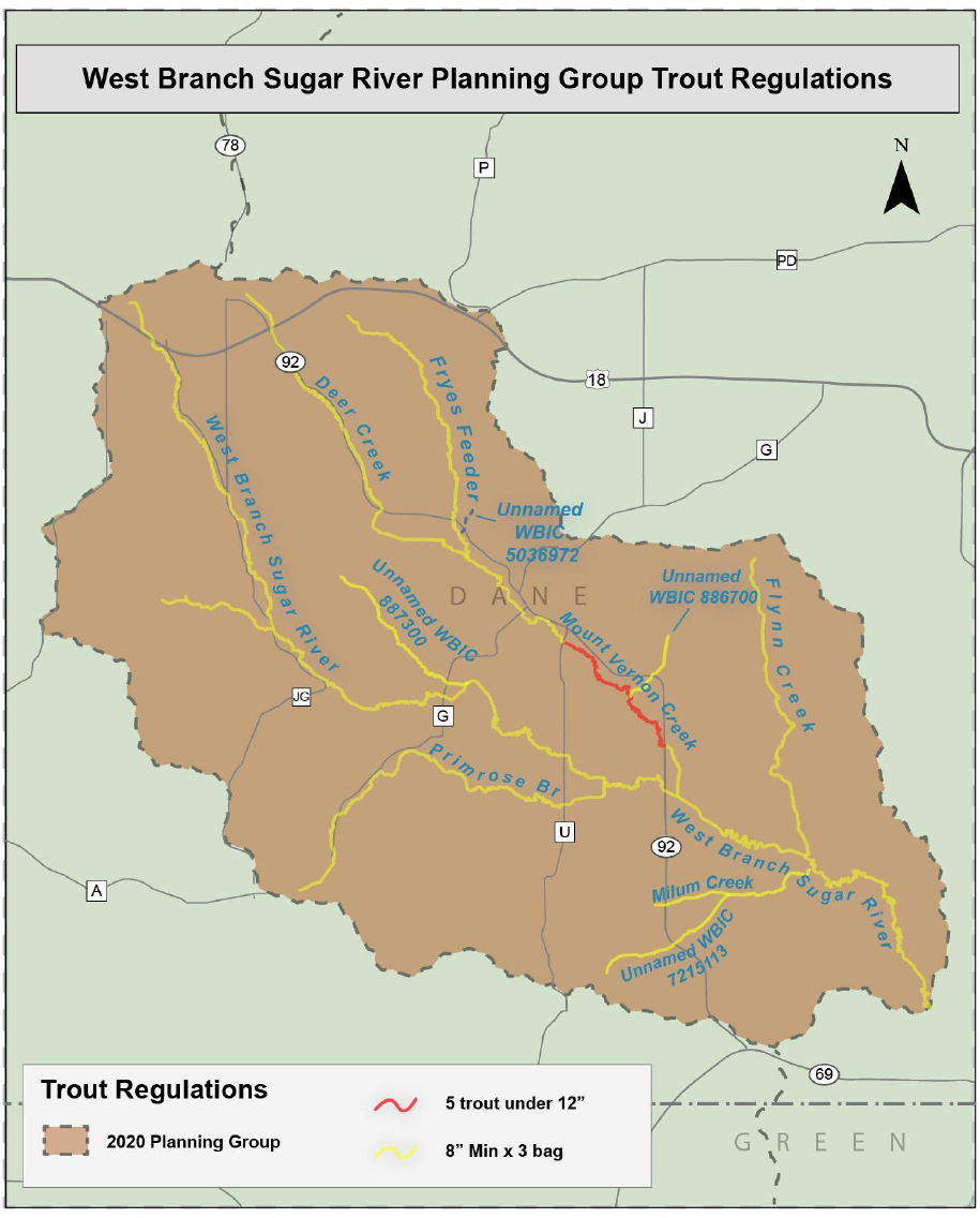
Mount Vernon Creek previously had a catch and release and artificial lure-only
section from State Hwy 92 upstream to HWY U. This regulation was modified in 2016
to the current five trout under 12 inches regulation to continue to protect quality-
sized fish (greater than 12 inches) from harvest but allow anglers harvest
opportunities on smaller trout. The rest of the watershed is regulated under the
standard county-wide 8-inch minimum, three daily bag limit for trout (Figure 2).
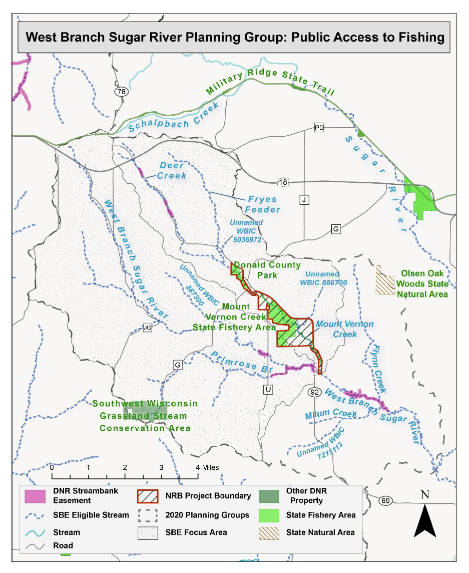
PUBLIC ACCESS
The largest swaths of DNR-owned lands in this area are along Mount Vernon Creek
and are within the Mount Vernon Creek Fishery Area in the town of Mount Vernon.
Donald Park is part of the Dane County Park system and adjoins the DNR Fishery Area
and offers additional access to Deer Creek. Public access is excellent in this area,
with four designated parking areas and several additional road-stream crossings in
addition to several DNR and Dane County easements that provide angler access
along the West Branch Sugar River, Primrose Branch and Deer Creek (Figure 3).
Methods
Understanding the natural reproduction and recruitment of a stream is critical to
managing trout populations. In our fishery assessments, natural recruitment is
defined by juvenile fish surviving to age-1. Natural reproduction is the presence of
age-0 fish (young-of-year, YOY), and they are more difficult to accurately assess since
their vulnerability to electrofishing gear is more variable than larger-sized fish.
Additionally, YOY are not evenly distributed since they often occur upstream in
nursery habitats and migrate downstream to adult and juvenile habitats later in life.
Therefore, documenting the lack of natural reproduction does not mean there is
necessarily a complete lack of natural recruitment.
To assess recruitment to age-1, all stocking of fingerling trout was suspended the
year prior to these surveys. Our assumption was that all yearling (age-1) trout
7
observed are from natural recruitment somewhere in the watershed, and all YOY
(age-0) trout are from natural reproduction. If previous stocking occurred, age-2 and
older fish are assumed to be from mixed sources. High levels of natural reproduction,
natural recruitment and several age classes without stocking indicate self-sustaining
Class 1 waters. We infer put-and-grow stocking was effective if we observe an
absence or low abundance of yearling trout but an abundance of adult trout and
conclude a given stream should be classified as Class 2. Marginal waters where only
stocked fish survive during early spring and summer with limited carry-over and no
reproduction are Class 3.
COVID-19 safety precautions limited our fieldwork in 2020 and impacted our
scheduled work in 2021. For this report, I used 2020 data for Flynn Creek, Fryes
Feeder, Milum, unnamed WBIC 5036972 (Spring Pond tributary to Fryes Feeder),
unnamed WBIC 886700 (tributary to Mount Vernon along Spring Rose Road) and the
unnamed WBIC 887300 (tributary to West Branch Sugar River). I used 2021 data to
describe Deer Creek, West Branch Sugar River, Mount Vernon Creek and the unnamed
WBIC 7215113 (tributary to Milum Creek). We surveyed three stations in Fryes Feeder,
one in Milum Creek, one on the unnamed tributary to Milum Creek, two in the
unnamed tributary to West Branch Sugar River, three in Flynn Creek, one in the
unnamed tributary to Mount Vernon Creek, two in Primrose Branch, four in Mount
Vernon Creek, five in the West Branch Sugar River and one in Deer Creek (see Figure 1
for map of sample locations). All 23 stream sites were surveyed with either a tow
behind barge stream shocking unit or backpack electrofishing unit.
The number of fish sampling sites in a particular stream was dependent on the
length of the stream following DNR Fish Management Handbook protocols. One
sampling site is required for stream segments less than 1.5 miles, two sites for stream
segments between 1.5-3 miles and one site every three miles on long rivers (minimum
three sites). The length of each fish survey at a particular site is determined by
stream width; thirty-five times the mean stream width on segments greater than 3
meters and 100 meters minimum for streams less than 3 meters wide.
For each sampling site, we calculated the catch-per-unit-effort (CPUE) by dividing the
number of fish collected by the length of the survey yielding a number of trout per
mile estimate. This procedure allows for straightforward analyses of catch rates
within and among stream sites as well as standardized regional and statewide
comparisons. Fish length data are analyzed by size classes and age groups of
interest. These groups include the number of age-0 (YOY), age-1 yearlings and adult
trout (age-2+). YOY are fish less than 4 inches in length, yearlings are between 4 and
7.9 inches for brown trout (between 4-7 inches for brook trout), and adults are
considered greater than 8 inches for brown trout (greater than 7 inches for brook
trout). Preferred-sized fish are often of special interest to anglers and are fish greater
than 12 inches for brown trout (greater than 10 inches for brook trout).
8
All fish encountered during the survey were collected. We recorded the species of
fish and total length (nearest tenth of an inch). Non-trout species were counted to
calculate the cold-water index of biotic integrity (IBI) score (0-100). For added
context, catch rates of mottled sculpin (less tolerant of poor water quality and a
cold-water indicator species) and white sucker (tolerant of poor water quality and
warmer water) were also evaluated as a proxy for water temperature profiles at each
survey station. DNR Fisheries Management Handbook chapter 510 details each of the
sampling protocols in greater detail. All fish were returned to the stream.
Water quality and habitat metrics were also collected at each survey site. Streamflow
(cubic feet per second, CFS) was calculated at one cross-sectional transect at each
site using a HACH FH950 handheld flow meter. Temperature, dissolved oxygen and
specific conductivity and pH were also measured using a handheld YSI Pro 2030
meter. Stream habitat metrics were collected using a DNR qualitative habitat rating
form. For streams less than 10 meters wide, ratings included riparian buffer width,
bank erosion, pool area, width: depth ratio, riffle: riffle or bend: bend ratio, fine
sediments and cover for fish. For streams greater than 10 meters wide, ratings
included bank stability, maximum thalweg depth, riffle: riffle or bend: bend ratio,
rocky substrate and cover for fish. All data was recorded digitally using weatherproof
handheld Toughbook™ laptops and a custom software application.
Results
Brown trout were collected in all 23 sites we sampled (Figure 1, Table 2) and average
catch rates for YOY brown trout (less than 4 inches) was 109 per mile, yearling (4-8
inches) 189 per mile, adult (greater than 8 inches) 168 per mile, preferred (greater
than 12 inches) 55 per mile and fish ranged in size from 2 inches to 21 inches. YOY
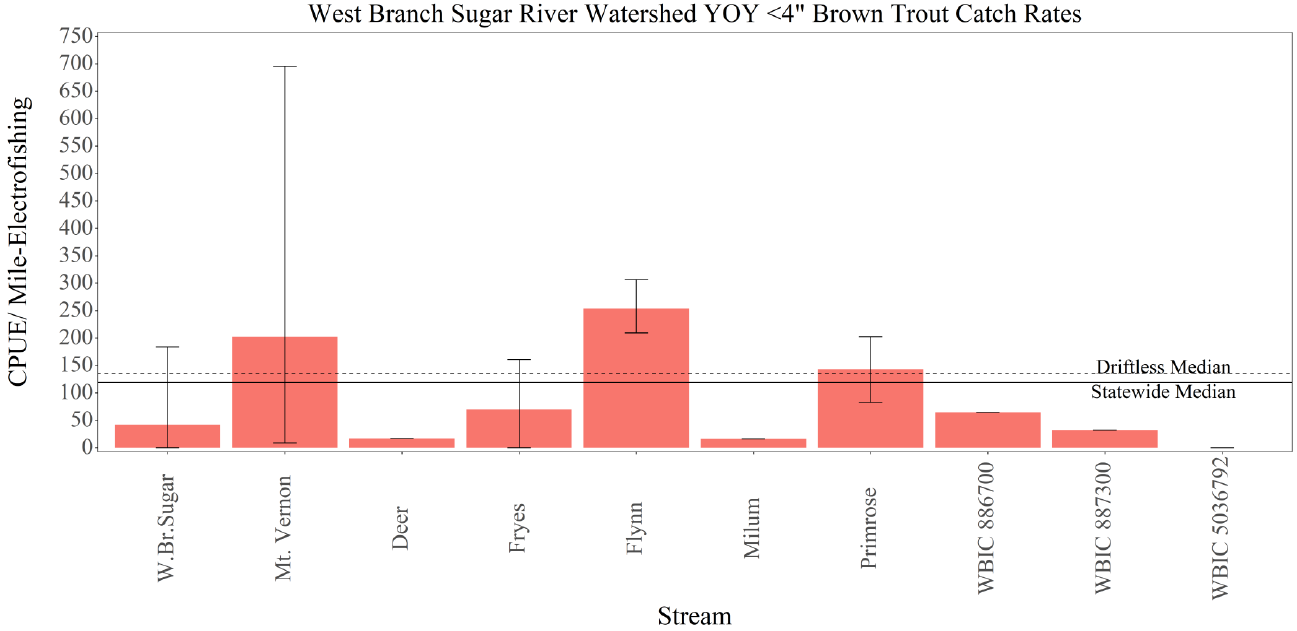
brown trout (natural reproduction) were observed in twenty locations (Figure 4).
Yearling brown trout were observed in twenty-one locations (Figure 5), and adult
brown trout were observed at nineteen sites (Figure 6).
Natural reproduction of brown trout across the watershed was patchy with a mix of
high performing, poorly performing and moderately performing reaches. For
example, 35% (8 of 23) of the stations had YOY catch rates exceeding the statewide
benchmarks (Tables 6-7), but 13% (3 of 23) had no natural reproduction whatsoever.
The remaining 12 sites had some natural reproduction but were below the statewide
benchmark (Table 2).
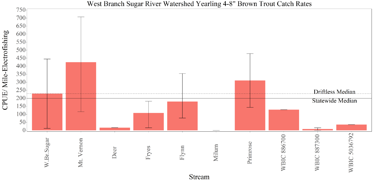
Yearling catch rates for brown trout across the watershed followed a similar pattern
as YOY, nine stations had catch rates which exceeded the statewide median, only two
stations recorded zero yearling-sized fish, and the remaining twelve stations had
some yearling production but were below regional benchmarks (Figure 5). The highest
catch rates for yearling-size brown trout were at HWY G in Mount Vernon Creek (707
9
per mile), HWY 92 in Mount Vernon Creek (467 per mile), followed by HWY G at the
West Branch Sugar River station (445 per mile, Table 2).
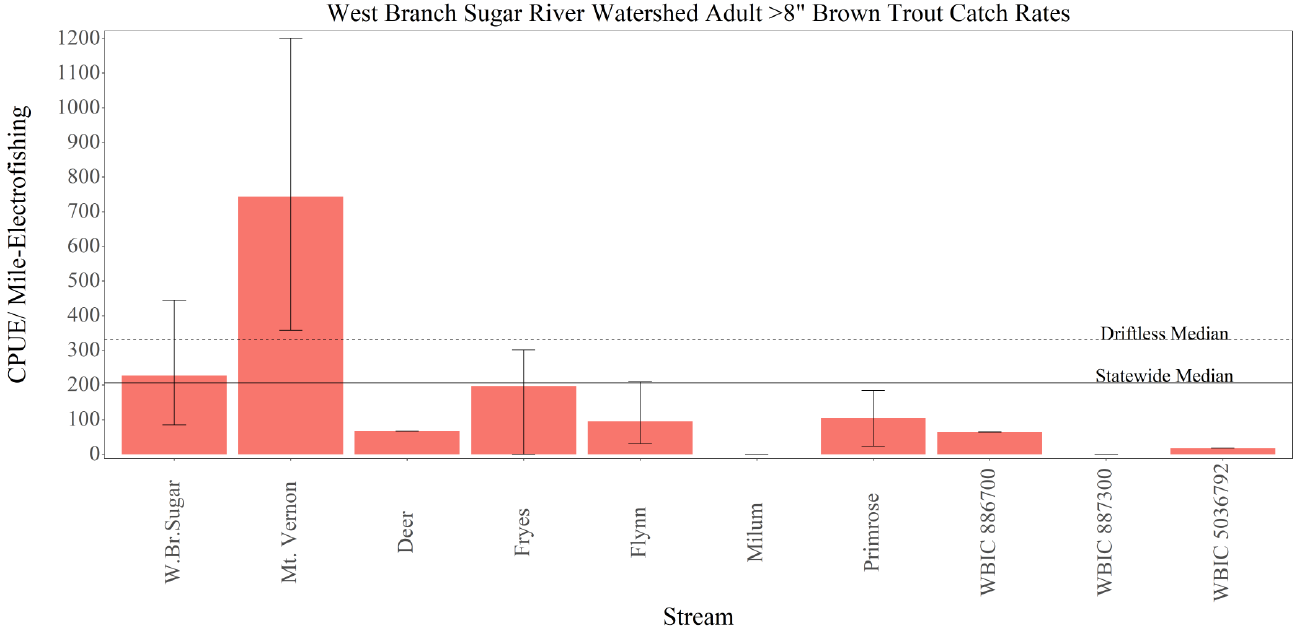
For adult brown trout , Fryes Feeder, Flynn and Mount Vernon creeks and West
Branch Sugar River had stations with catch rates that exceeded the statewide
benchmark (Table 2, Figure 6). The highest catch rates of adult brown trout over 8
inches were found at the HWY G station in Mount Vernon Creek (1201 per mile). The
smaller, headwater streams generally lacked adult brown trout (e.g., Fryes Feeder at
Town Hall Road, Milum Creek).
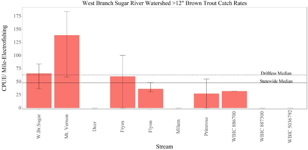
For fish larger than 12 inches, twelve stations exceeded statewide benchmark for
catch rates in this size category. For example, Fryes Feeder, Flynn Creek, Primrose
Branch, Mount Vernon Creek and West Branch Sugar River had stations with average
catch rates that exceeded the statewide benchmark (Figure 7). The highest catch
rates of adult brown trout greater than 12 inches were found in Mount Vernon Creek.
Only the smallest tributaries and headwater reaches of larger streams lacked fish of
this size class. Brown trout greater than 18 inches were observed in Fryes Feeder and
West Branch Sugar River (Table 2).
Brook trout were observed in Fryes Feeder, Milum Creek, the unnamed tributary to
West Branch Sugar River, Flynn Creek, Primrose Branch, the unnamed tributary to
Milum Creek, Mount Vernon Creek, Deer Creek and West Branch Sugar River (Table 3).
Fryes Feeder had the highest catch rates for brook trout, with mean catch rates of
YOY at 285 per mile, yearling 90 per mile and adults at 72 per mile. The survey at
Town Hall Road had the most fish and multiple year classes represented in the
sample (Table 3).
Brook trout were observed in ten streams, but Fryes Feeder, the unnamed tributary
to West Branch Sugar River, the unnamed tributary to Fryes Feeder and Primrose
Branch had average adult catch rates exceeding the minimal fishable population of
more than 50 adults per mile (Table 3, Figure 8). These four streams had excellent
brook trout natural reproduction ranging from 209 to 531 per mile. Fryes Feeder,
Flynn Creek and the tributary of West Branch Sugar River had yearling brook trout
catch rates exceeding the statewide median, and all other stations were well below
that mark (Figure 9). Fourteen of the sixteen brook trout sites had adult-sized fish
greater than 7 inches represented in the sample, and four exceeded the regional
benchmarks for this size category (Table 2, Figures 9-10). Fryes Feeder, Flynn,
Primrose Branch, Mount Vernon and Deer creeks had brook trout over 10 inches
recorded in the survey, but none of them exceeded the regional benchmarks.
The presence of cold-water indicator species like sculpin throughout all streams in
the watershed indicates the stream temperatures are suitable and water quality
sufficient to support increased trout abundances with habitat improvements. Mottled
sculpin were observed throughout the watershed, and the highest abundances were
in Milum Creek (981 per mile) followed by West Branch Sugar River (924 per mile),
10
Primrose Branch (773 per mile), Mount Vernon Creek (753 per mile) and Fryes Feeder
(684 per mile). White suckers were observed in the larger, lower reaches of the
watershed, with the highest abundances in the West Branch Sugar River and Mount
Vernon Creek (Table 5).
ANNUAL TREND SURVEY STATIONS
The four annual DNR trend surveys in this watershed offer unique perspectives
regarding the species composition and relative abundance of the trout streams in
this region. Deer Creek at HWY 92 site is a small, coldwater stream that once was
dominated by brook trout but has since transitioned to a lower abundance brown
trout fishery despite brook trout stocking as recently as 2018 (Figure 12). Similarly, the
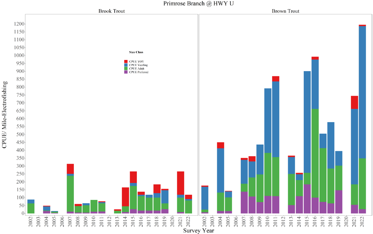
Primrose Branch at HWY U trend site has experienced increased brown trout
abundances while the brook trout population experiences variable recruitment
(Figure 13).
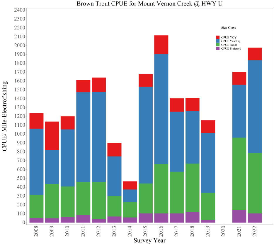
With regular natural recruitment and all size classes of trout represented in our
surveys, Mount Vernon Creek at HWY U continues to be a robust trout stream with
total catch rates exceeding 1,000 fish per mile and most recently boasting a total
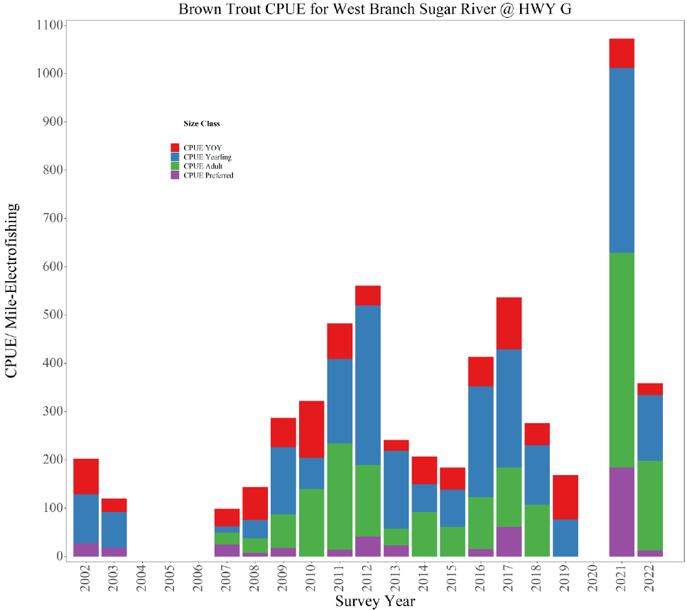
catch rate of nearly 2,000 fish per mile (Figure 14). The West Branch Sugar River at
HWY G trend site has experienced fluctuations in the trout population over the years,
ranging from ~100 per mile to over 1,000 trout per mile (Figure 15).
COLDWATER INDEX OF BIOTIC INTEGRITY SCORES AND HABITAT QUALITY
Median coldwater IBI score across all sites in the West Branch Sugar River watershed
was 80 (out of 100, with an average score of 75) and exceeded the statewide trout
stream (60), Driftless Area trout stream (50) and Dane County (50) median scores. The
average qualitative habitat rating for the watershed was 56 (out of 100), with all
stations scoring as “Excellent, “Good” or “Fair,” with two “Poor” scores. Average
riparian buffer scores were excellent (12.4 out of 15). Bank erosion scores varied
widely, and nearly all stations had some erosion issues (range 0-15 out of 15).
Adequate habitats, defined as pool area, were rare, with a median score of 3 and a
maximum score 10 (out of 15). Median scores for other physical habitat metrics
showed similar heterogeneous patterns, including width: depth ratio (5 out of 15),
riffle habitat (5 out of 15), fine sediments present (5 out of 15) and cover for fish (10
out of 15). The average temperature across all stations was 58.1°F (ranging from
51.8°F to 64.8°F). The average stream flow was 9.8 CFS (ranging from 0.71 – 40.97 CFS),
with an average width of 3.5 meters (Table 4).
Discussion
With elevated catch rates across all size classes, Mount Vernon Creek and the West
Branch Sugar River are providing excellent angling opportunities. The average catch
rate for brown trout across the nine survey sites in these streams was 854 per mile.
The highest catch rates in the watershed were 2,600 per mile at HWY G in Mount
11
Vernon Creek and 1,088 per mile at HWY G on West Branch Sugar River. Smaller
tributaries of these streams are performing well too. For example, total catch rates in
Fryes Feeder (375 per mile), Flynn Creek (528 per mile) and Primrose Branch (455 per
mile) had average brown trout catch rates exceeding the minimum fishable
population (50 per mile, adult sizes) and therefore, provide quality angling
opportunities. There are brook trout highlights as well. For example, Fryes Feeder, the
unnamed tributary to West Branch Sugar River, Flynn Creek, the unnamed tributary to
Deer Creek and Primrose Branch all had total catch rates high enough to provide
quality angling opportunities for brook trout.
We documented brown trout steadily outnumbering brook trout in two streams in
this watershed. In the early 2000s, it was rare to find a brown trout in Deer Creek, but
our survey in 2022 showed brown trout outnumbering brook trout by a 6:1 margin and
the total number of fish has declined (Figure 12). At Primrose Branch, brook trout
numbers have fluctuated with year-class strength, while we’ve seen a steady increase
in brown trout. Though the overall trout abundances remain high, brook trout were
outnumbered 10:1 by brown trout in our recent survey (Figure 13). Without
interventions, we should expect similar patterns in southern Wisconsin brook trout
populations as climate change results in trout streams becoming more conducive to
brown trout and less so for brook trout. Once brown trout have displaced brook trout
in small streams like Deer Creek and Primrose Branch, stocking is not expected to
help brook trout regain dominance. Habitat improvement plans, including riparian
corridor management actions, along brook trout waters should proceed cautiously.
They should incorporate techniques designed to promote brook trout with more
shade, pools and in-stream wood than what is typically prescribed for brown trout
management.
Natural reproduction, yearling survival and total adult catch rates in Fryes Feeder,
Flynn Creek, Primrose Branch, West Branch Sugar River and the unnamed tributary to
West Branch Sugar River warrant upgrading to Class 1 trout water. Currently
unclassified trout waters, the unnamed tributary to Mount Vernon Creek and the
unnamed tributary to Fryes Feeder, have natural reproduction and sufficient adult
abundances to classify them as Class 1 trout waters as well. Deer Creek is currently
Class 2 trout waters but should be upgraded to Class 1 in the next reclassification
cycle. No stocking is needed in the watershed to support a healthy trout fishery while
providing reliable angling opportunities. Milum Creek and the unnamed tributary to
Milum Creek do not currently support trout fisheries in high enough abundance
(likely habitat limited) to warrant upgrading to classified trout water at this time.
In contrast to regional flooding in 2018 which likely decreased trout catch rates in
previous years, the 2020 and 2021 data presented here indicate post-flood
conditions, which have resulted in increased trout production and year-class
formation in some locations. For example, Fryes Feeder, Flynn Creek, Primrose Creek,
Mount Vernon Cree and West Branch Sugar River each had YOY production and
yearling recruitment values well-above regional benchmarks. For example, Mount
12
Vernon Creek at HWY G station had a catch rate of YOY brown trout over five times
greater than the Driftless Area benchmark. Future surveys will examine whether or
not newly scoured spawning riffles and modified stream morphology as a result of
the flooding will continue to produce strong year classes and whether or not
contemporary elevated YOY production leads to increased adult trout abundances
for anglers to target.
In contrast to high recruitment in most stream segments in the watershed, the West
Branch Sugar River had lower brown trout recruitment than regional benchmarks in
83% of the sites we surveyed (all except HWY G location), resulting in a stream
average of only 42 YOY per mile (Table 2). The abundances for larger-sized fish were
improved, with most sites meeting or exceeding regional benchmarks but still lower
than what the river could support given its flow and size. The habitat scores were
generally acceptable, but the substrate was often silty with few pools and riffles.
Revisiting old habitat improvement projects to ensure they are still functioning and
implementing new ones to increase the amount of pool and riffle habitats, with
overhead cover for adult fish, will likely result in increased fish abundances across
all-size classes and improve the overall size structure in the process.
In addition to physical habitat stressors caused by urban and agricultural pressures,
along with climate change, invasive species like New Zealand mudsnails continue to
colonize Wisconsin’s trout streams. Established populations have been found in
Badger Mill Creek and the Sugar River. Research and monitoring are underway to
determine any impacts new invaders like mudsnails pose to the trout fishery and
ecology of the stream. Anglers and paddlers need to be mindful of transporting these
organisms between the waterways they recreate in. Freezing gear or robust
disinfecting protocols (Virkon™, steam) are the best ways to be sure your gear is free
of aquatic invasive species between trips.
Management Goals and Objectives
1) Goal –Maintain high-quality recreational fishing opportunities for preferred-sized
trout (greater than 12 inches) in Mount Vernon Creek
Objectives – a. Maintain adult size trout (greater than 8 inches) CPUE >700/ mile
(Driftless Area 75
th
percentile is 677/mile and current stream
average is 714 /mile)
b. Maintain preferred-size trout CPUE >115/ mile (Driftless Area 75
th
percentile is 115/mile and current stream average is 139 /mile)
Strategy – Maintain high quality trout habitats instream and along riparian
corridor while promoting increased angler access to a feasible extent along public
lands and easements
a. Collaborate with local landowners, conservation organizations and
government agencies to acquire easements or lands to increase buffer
13
areas, encourage native vegetated riparian corridors, increase public
access and implement habitat improvement projects where needed.
2) Goal- Increase adult trout (trout over 8 inches) abundances in West Branch Sugar
River
Objectives – Increase adult catch rates of brown trout >330/ mile (Driftless Area
50
th
percentile is 330/mile and current stream average is 228/mile)
Strategy – Invest Trout Stamp habitat funds to conduct 1-2 miles of habitat
improvement projects along publicly accessible lands and easements before the
next survey rotation.
a. Collaborate with local landowners to secure new easements and lands with
willing partners in the watershed.
ADDITIONAL MANAGEMENT RECOMMENDATIONS:
1) Upgrade Class 2 trout waters of Deer Creek, Fryes Feeder, Flynn Creek, Primrose
Branch and West Branch Sugar River to Class 1 trout waters in 2024 reclassification
cycle
2) Reclassify the unnamed tributary to West Branch Sugar (WBIC 887300) unnamed
tributary to Mount Vernon Creek (WBIC 886700) and the unnamed tributary to
Fryes Feeder (WBIC 5036792) from unclassified to Class 1 trout waters in 2024
reclassification cycle
3) Evaluate angler-use and harvest within the watershed using angler creel surveys
4) Continue targeted DNR Stream Bank Easement Outreach to interested landowners
and acquire new lands within Natural Resource Board acquisition boundaries.
a. Collaborate with Dane County to engage with interested landowners with
expired stream bank easements to renew those agreements to extent
feasible
5) Maintain harvest opportunities with current regulation of an 8-inch minimum,
three daily bag limit throughout most of the watershed
a. Evaluate Mount Vernon Creek’s special regulation daily bag limit of five
trout under 12 inches for waters in between HWY U and HWY 92 in the next
rotation, based on size structure data, angler preferences and angler
harvest.

14
Tables and Figures
Table 1. Trout stocking in West Branch Sugar River Watershed 2015-2021.
Stream
Species
2015
2016
2017
2018
2019
2020
2021
2022
Deer Creek
Brook
1065
1000
450
500
Flynn Creek
Brook
2027
1000
450
350
Fryes Feeder
Brook
536
500
225
250
Mount Vernon
Brook
60
Primrose Branch
Brook
1103
1000
922
500
500
West Branch Sugar
Brook
4000
4060
4000
2000
3000
Brown
1271

15
Table 2. Brown trout catch rates in for the West Branch Sugar River watershed. Catch per unit effort (CPUE) units are the numbers of
fish per electrofishing mile of young-of-year (YOY), yearlings and adults of various sizes. Stream names shown in bold indicate
survey data from 2020, all others are from 2021 surveys. Values shown in red indicate catch rate below Statewide median CPUE.
Stream
Station (ID)
N
Mean
Length
(In)
<4” YOY
CPUE
4-8”
Yearling
CPUE
>8”
CPUE
>12”
Preferred
CPUE
>15”
Memorable
CPUE
>18”
Trophy
CPUE
Total
CPUE
Fryes Feeder
Stream Average
20.67
7.22
69.74
108.63
197.14
60.35
13.41
5.36
375.51
Town Hall Rd. (44)
4
3.53
48.28
16.09
0.00
0.00
0.00
0.00
64.37
HWY 92 (46)
26
9.89
0.00
128.75
289.68
80.47
0.00
16.09
418.43
Near Weeping Willow Dr. (45)
32
8.24
160.93
181.05
301.75
100.58
40.23
0.00
643.74
Milum Cr.
Fritz Rd. (49)
1
3.50
16.09
0.00
0.00
0.00
0.00
0.00
16.09
Unnamed WBIC 887300
Stream Average
2.50
3.70
32.19
8.05
0.00
0.00
0.00
0.00
40.24
Rettenmund Rd. (61)
3
4.60
32.19
16.09
0.00
0.00
0.00
0.00
48.28
HWY G bridge (60)
2
2.80
32.19
0.00
0.00
0.00
0.00
0.00
32.19
Flynn Cr.
Stream Average
33.67
5.34
253.66
179.33
95.28
36.53
5.11
0.00
528.27
HWY A (41)
23
4.77
245.23
76.64
30.65
30.65
15.33
0.00
352.52
Fritz Rd. (43)
48
6.84
209.21
354.06
209.21
48.28
0.00
0.00
772.49
North Fritz Rd. (42)
30
4.41
306.54
107.29
45.98
30.65
0.00
0.00
459.81
Unnamed WBIC 886700
HWY 92 (58)
16
6.49
64.37
128.75
64.37
32.19
0.00
0.00
257.50
Unnamed WBIC 5036972
HWY 92 (62)
3
6.33
0.00
35.76
17.88
0.00
0.00
0.00
53.64
Primrose Br.
Stream Average
56.00
6.10
142.72
310.63
103.89
27.59
0.00
0.00
557.23
HWY U (55)
81
7.27
82.77
478.21
183.93
55.18
0.00
0.00
744.90
Primrose Center Bridge (56)
31
4.93
202.66
143.05
23.84
0.00
0.00
0.00
369.55
Mount Vernon
Stream Average
217.00
8.47
202.75
425.23
714.45
138.77
13.95
0.00
1377.91
Park to HWY G (50)
454
7.24
695.47
706.96
1201.26
183.93
17.24
0.00
2609.44
HWY U (35)
294
8.10
143.69
597.76
816.16
143.69
0.00
0.00
1707.05
DNR South Lot HWY 92 (51)
186
8.20
132.81
468.74
835.92
164.06
7.81
0.00
1453.10
DNR North Lot HWY 92 (53)
97
8.50
32.84
236.48
361.28
59.12
0.00
0.00
637.17
HWY 92 (52)
54
10.32
8.94
116.23
357.63
143.05
44.70
0.00
482.80
W.Br.Sugar River
Stream Average
38.80
9.56
42.23
228.72
228.12
66.01
17.76
6.66
502.13
Fritz Rd. (64)
17
11.45
6.07
12.15
85.02
36.44
18.22
12.15
103.24
HWY G (68)
71
7.73
183.93
444.49
444.49
61.31
0.00
0.00
1088.22
HWY U (63)
41
8.79
0.00
363.85
209.91
83.97
27.99
0.00
573.77
Primrose Center Rd. (69)
41
9.20
13.99
265.89
293.88
83.97
13.99
13.99
573.77
HWY 92 (70)
24
10.65
7.15
57.22
107.29
64.37
28.61
7.15
171.66
Deer Cr.
HWY 92 (39)
6
8.25
16.59
16.59
66.36
0.00
0.00
0.00
99.55
Statewide Median CPUE
119.00
199.00
206.00
48.00
537.00
Driftless Median CPUE
136.00
230.00
331.00
63.00
730.00

16
Table 3. Brook trout catch rates for the West Branch Sugar River watershed. Catch per unit effort (CPUE) units are numbers of fish
per electrofishing mile of young-of-year (YOY), yearlings and adults of various sizes. Streams shown in bold indicate survey data
from 2020, all others are from 2021 surveys. Values shown in red indicate catch rate below Statewide median CPUE.
Stream
Station (ID)
Numbe
r of fish
Mean
Length
(In)
<4”
YOY
CPUE
4-7”
Yearling
CPUE
>7”
CPUE
>10”
Preferred
CPUE
Total
CPUE
Fryes Feeder
Stream Average
27.50
5.41
285.66
90.53
82.48
10.06
458.66
Town Hall Rd. (44)
47.00
3.82
531.08
160.93
64.37
0.00
756.39
Near Weeping Willow Dr. (45)
8.00
7.00
40.23
20.12
100.58
20.12
160.93
Milum Cr.
Fritz Rd. (49)
3.00
3.57
32.19
16.09
0.00
0.00
48.28
Unnamed WBIC 887300
Stream Average
33.50
5.02
209.22
233.36
88.52
0.00
539.13
Rettenmund Rd. (61)
47.00
4.41
386.24
273.59
80.47
0.00
756.39
HWY G bridge (60)
20.00
5.63
32.19
193.12
96.56
0.00
321.87
Flynn Cr.
Stream Average
15.67
4.46
151.48
51.86
36.78
5.36
245.23
HWY A (41)
1.00
4.20
0.00
15.33
0.00
0.00
15.33
Fritz Rd. (43)
20.00
4.73
209.21
48.28
64.37
16.09
321.87
North Fritz Rd. (42)
26.00
4.46
245.23
91.96
45.98
0.00
398.50
Unnamed WBIC 5036972
HWY 92 (62)
13.00
8.22
0.00
35.76
196.70
0.00
232.46
Primrose Br.
Stream Average
28.50
4.74
210.66
9.20
80.39
4.60
300.24
HWY U (55)
29.00
5.46
147.14
18.39
101.16
9.20
266.69
Primrose Center Bridge (56)
28.00
4.02
274.18
0.00
59.61
0.00
333.79
Unnamed WBIC 7215113
Peerless Rd.
4.00
6.88
21.46
0.00
64.37
0.00
85.83
Mount Vernon
Stream Average
7.00
9.01
0.00
9.86
31.61
9.45
44.75
Park to HWY G (50)
3.00
9.67
0.00
0.00
17.24
5.75
17.24
DNR South Lot HWY 92 (53)
11.00
8.34
0.00
19.71
45.98
13.14
72.26
West. Br. Sugar River
HWY G (68)
7.00
5.59
45.98
15.33
45.98
0.00
107.29
Deer Cr.
HWY 92 (39)
5.00
7.70
0.00
33.18
33.18
16.59
82.96
Driftless Median CPUE
132
86
85
18
219
Statewide Median CPUE
148
156
85
18
336

17
Table 4. Coldwater index of biotic integrity (IBI) scores, water temperature (Temp.), flow (cubic
feet per second), stream width and habitat ratings for the West Branch Sugar River watershed.
Streams shown in bold indicate survey data from 2020, all others are from 2021 surveys.
Stream
Station (ID)
IBI
Temp
. (°F)
Flow
Mean
Stream
Width
(meters)
Habita
t
Score
Fryes Feeder
Town Hall Rd. (44)
80
56
1.41
1.5
53
HWY 92 (46)
70
55
5.65
2.9
53
Near Weeping Willow Dr. (45)
80
52
Milum Cr.
Fritz Rd. (49)
75
58
1.41
1.7
45
Unnamed WBIC 887300
Rettenmund Rd. (61)
50
51.8
1.41
2
73
HWY G bridge (60)
80
54
3.18
1.6
43
Flynn Cr.
HWY A (41)
80
56
4.24
2.1
20
Fritz Rd. (43)
80
57
4.24
1.8
72
North Fritz Rd. (42)
80
58
4.24
2.9
43
Unnamed WBIC 886700
HWY 92 (58)
80
64
0.71
2.5
48
Unnamed WBIC 5036972
HWY 92 (62)
50
54
Primrose Br.
HWY U (55)
80
60
4.94
2.6
53
Primrose Center Bridge (56)
80
53.8
15.89
2.2
62
Mount Vernon
Park to HWY G (50)
80
59
36.02
5.7
57
HWY U (35)
80
62.5
15.89
7.7
80
DNR South Lot HWY 92 (51)
90
63
16.60
6.6
67
DNR North Lot HWY 92 (53)
80
55.9
15.89
6.5
50
HWY 92 (52)
80
57
18.36
5.5
62
W.Br. Sugar River
Fritz Rd. (64)
50
61
40.97
8.3
55
HWY G (68)
80
62.7
8.12
4.2
57
HWY U (63)
70
62.5
9.89
3.2
77
Primrose Center Rd. (69)
80
60.6
8.48
4.2
67
HWY 92 (70)
90
61.2
16.95
5.6
57
Deer Cr.
HWY 92 (39)
80
64.8
1.77
2
72
Unnamed WBIC 7215113
Peerless Rd.
50
58
1.06
1.75
43

18
Table 5. Total catch rates (CPUE; catch per mile) for mottled sculpin and white sucker, IBI scores, and predicted stream natural
community categories for the West Branch Sugar River watershed. Streams shown in bold indicate survey data from 2020, all others
are from 2021 surveys.
Stream
Station (ID)
IBI
Score
Natural Community
Prediction
mottled
sculpin CPUE
white sucker
CPUE
Fryes Feeder
Town Hall Rd. (44)
80
Cool-Cold Headwater
32.19
0.00
HWY 92 (46)
70
Coldwater
48.28
0.00
Near Weeping Willow Dr. (45)
80
Cool-Cold Headwater
683.97
0.00
Milum Cr.
Fritz Rd. (49)
75
Coldwater
981.69
0.00
Unnamed WBIC 887300
Rettenmund Rd. (61)
50
Coldwater
-
-
HWY G bridge (60)
80
Coldwater
48.28
0.00
Flynn Cr.
HWY A (41)
80
Coldwater
429.16
0.00
Fritz Rd. (43)
80
Coldwater
579.36
0.00
North Fritz Rd. (42)
80
Coldwater
183.93
0.00
Unnamed WBIC 886700
HWY 92 (58)
80
Coldwater
0.00
177.03
Unnamed WBIC 5036972
HWY 92 (62)
50
Coldwater
0.00
209.22
Primrose Br.
HWY U (55)
80
Cool-Cold Mainstem
772.48
0.00
Primrose Center Bridge (56)
80
Cool-Cold Mainstem
238.42
0.00
Mount Vernon
Park to HWY G (50)
80
Coldwater
752.94
252.89
HWY U (35)
80
Cool-Cold Mainstem
727.70
111.95
DNR South Lot HWY 92 (51)
90
Coldwater
695.29
398.42
DNR North Lot HWY 92 (53)
80
Cool-Cold Mainstem
387.56
13.14
HWY 92 (52)
80
Cool-Cold Mainstem
330.81
768.91
W.Br.Sugar River
Fritz Rd. (64)
50
Cool-Cold Mainstem
48.59
346.16
HWY G (68)
80
Cool-Cold Mainstem
904.29
996.26
HWY U (63)
70
Cool-Cold Mainstem
727.70
111.95
Primrose Center Rd. (69)
80
Cool-Cold Mainstem
923.62
391.84
HWY 92 (70)
90
Cool-Cold Mainstem
379.09
343.33
Deer Cr.
HWY 92 (39)
80
Coldwater
580.69
0.00
Unnamed WBIC 7215113
Peerless Rd.
50
Coldwater
-
-

19
Table 6. Brook trout CPUE (fish/mile) percentile breakdown for stream surveys conducted on Class 1 trout streams in the Driftless
Area and statewide where at least one trout was collected, 2012-2021.
CPUE total
(All sizes)
CPUE age
0
(<4.0 inches)
CPUE age
1
(4.0-6.9 inches)
CPUE adult
(≥7 inches)
CPUE
preferred
(≥10 inches)
Percentile
Driftless
Statewide
Driftless
Statewide
Driftless
Statewide
Driftless
Statewide
Driftless
Statewide
10
15.1
22.9
16
16.1
12.4
16.1
12.8
15.3
6.5
5.7
25
53.0
96.6
46
45.3
30.5
48.3
30
32.2
11.1
10.3
35
107.1
174.7
68.6
72.4
44.9
80.5
47.9
48.3
14.3
12.8
50 (median)
219.9
336.8
128.7
145.3
80.5
149.2
80.5
80.5
16.1
16.4
65
402.3
579.7
209.2
241.4
150.9
257.2
124
129.4
29.1
27.5
75
590.1
772.5
321.9
365.5
234.2
366.7
177.7
185.2
37.5
37.4
90
1223.0
1488.4
787.1
812.3
548.7
662.7
347
344
64.4
64.4

20
Table 7. Brown trout CPUE (fish/mile) percentile breakdown for fishery surveys conducted on Class 1 trout streams in the Driftless
Area and statewide where at least one trout was collected, 2012-2021.
CPUE total
(All sizes)
CPUE age
0
(<4.0 inches)
CPUE age
1
(4.0-7.9 inches)
CPUE
adult
(≥ 8 inches)
CPUE
preferred
(≥12 inches)
Percentile
Driftless
Statewide
Driftless
Statewide
Driftless
Statewide
Driftless
Statewide
Driftless
Statewide
10
108.3
39.7
15.1
12.5
27.9
21
40.2
18.9
16.1
10.6
25
323.6
178.4
40.2
32.2
82.6
70.6
128.7
63.8
31.9
20.3
35
492.2
305.9
71.1
58.1
135.6
115
191.6
112.7
42.9
30.3
50 (median)
729.8
537.3
136.1
119.3
229.9
199.2
330.8
205.8
63.2
47.6
65
1121.4
880.6
256.1
247.5
383.2
337.2
509.7
341.9
85.8
72
75
1478.3
1241.7
405.4
402.1
518.8
482.8
677.6
479.2
115
91.4
90
2720
2203.1
856.7
933.5
877.1
836.6
1194.2
864.5
181.5
156.5
21
Figure 1. Stream classifications and fishery assessment survey sites within the Upper West
Branch Sugar River watershed.
22
Figure 2. Upper West Branch Sugar River watershed trout streams are regulated under the
county base 8-inch minimum length and three daily-bag limit.
23
Figure 3. West Branch Sugar River watershed public access points and DNR Stream Bank
Easement program eligible waters.
24
Figure 4. Average young-of-year (YOY; less than 4 inches) brown trout catch rates across all survey sites for each stream. Error bars
represent minimum and maximum catch rates observed in each stream.
25
Figure 5. Average yearling brown trout catch rates (between 4 to 8 inches) across all survey sites for each stream. Error bars
represent minimum and maximum catch rates observed in each stream.
26
Figure 6. Average adult brown trout catch rates (greater than 8 inches) across all survey sites for each stream. Error bars represent
minimum and maximum catch rates observed in each stream.
27
Figure 7. Average preferred brown trout catch rates (greater than 12 inches) across all survey sites for each stream. Error bars
represent minimum and maximum catch rates observed in each stream.

28
Figure 8. Average young-of-year (YOY; less than 4 inches) brook trout catch rates across all survey sites for each stream. Error bars
represent minimum and maximum catch rates observed in each stream.
29
Figure 9. Average yearling brook trout catch rates (from 4 to 7 inches) across all survey sites for each stream. Error bars represent
minimum and maximum catch rates observed in each stream.
30
Figure 10. Average adult brook trout catch rates (greater than 7 inches) across all survey sites for each stream. Error bars represent
minimum and maximum catch rates observed in each stream.
31
Figure 11. Average preferred brook trout catch rates (over 10 inches) across all survey sites for each stream. Error bars represent
minimum and maximum catch rates observed in each stream.
32
Figure 12. Size specific catch rates for brook and brown trout at the Deer Creek HWY 92 trend site (COVID-19 precautions prohibited
surveys in 2020 and no fish surveys were conducted in 2006, 2008-2012 and 2014-2015). YOY=young-of-year (fish less than 4 inches).
33
Figure 13. Total catch rates for brook and brown trout at the Primrose Branch at HWY U trend site (not surveyed in 2003, 2006, 2012
or 2020). YOY=young-of-year (fish less than 4 inches).
34
Figure 14. Size specific catch rates for brown trout at the Mount Vernon at HWY U trend site (COVID-19 precautions prohibited surveys in 2020).
YOY=young-of-year (fish less than 4 inches).
35
Figure 15. Size specific catch rates for brown trout at the HWY G trend site (not surveyed in 2004-2006, and COVID-19 precautions prohibited
surveys in 2020). YOY=young-of-year (fish less than 4 inches).
