
GUIDEBOOK
•
EMERGENCY
ACTION PLAN
Version 4.0
November 2019
i
TABLE OF CONTENTS
CHAPTER
1. INTRODUCTION .................................................................................................................................. 1
2. AUTHORITY ......................................................................................................................................... 5
3. MUTUAL AID AGREEMENTS ............................................................................................................ 7
4. FLOOD ORGANIZATION PERSONNEL .......................................................................................... 11
5. CONTACT LISTS ................................................................................................................................ 15
6. FLOOD ELEVATIONS, MAPPING, AND HISTORY ....................................................................... 18
7. TASKS AND PRIORITIZED ACTIONS ............................................................................................ 23
8. EMERGENCY SHELTERS ................................................................................................................. 25
9. EVACUATION .................................................................................................................................... 28
10. UTILITIES ............................................................................................................................................ 32
11. CRITICAL FACILITIES ...................................................................................................................... 36
12. HAZARDOUS MATERIALS .............................................................................................................. 39
13. COMMUNICATIONS ......................................................................................................................... 41
14. TRAINING AND EXERCISES ........................................................................................................... 45
15. MITIGATION, FLOODPLAIN MANAGEMENT AND INSURANCE: LESSONS LEARNED ..... 48
APPENDICES
APPENDIX A
LINKS TO RESOURCES .......................................................................................................................... 54
APPENDIX B
RECORD OF PLAN DISTRIBUTION ...................................................................................................... 62
RECORD OF PLAN UPDATES ................................................................................................................ 63
PUBLIC MEETING SIGN-IN SHEET ...................................................................................................... 64
PUBLIC MEETING COMMENT SHEET ................................................................................................. 65
SAMPLE RESOLUTION ........................................................................................................................... 66
CALL TREE ............................................................................................................................................... 68
PERSONNEL FOR FLOOD ORGANIZATION ....................................................................................... 69
ORGANIZATIONAL CHART .................................................................................................................. 71
ii
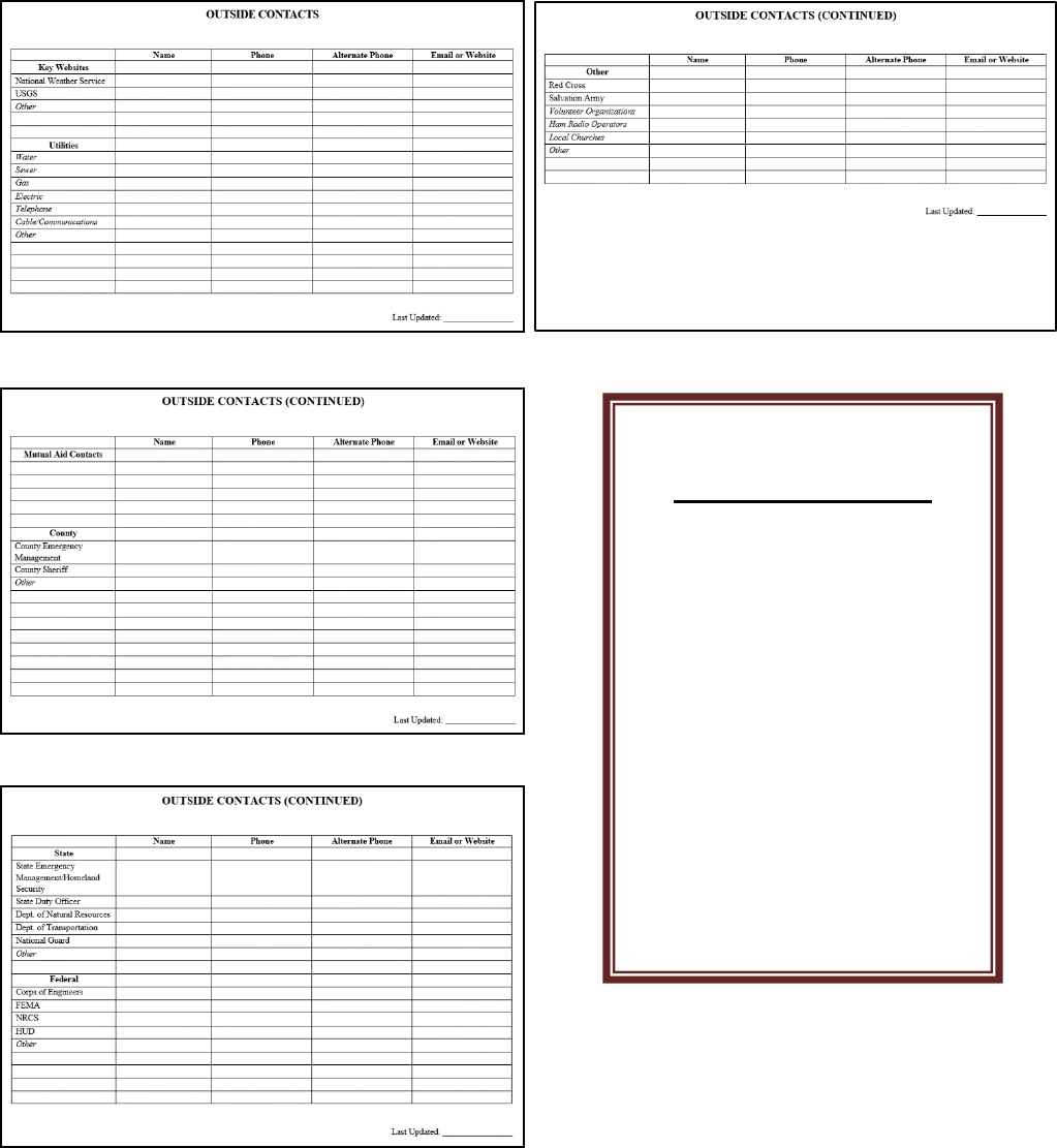
OUTSIDE CONTACTS ............................................................................................................................. 72
TASK SUMMARY LIST BY ELEVATION ............................................................................................. 76
TASK WORKSHEET ................................................................................................................................ 78
SUMMARY OF SHELTERS ..................................................................................................................... 80
EVALUATION OF SHELTERS ................................................................................................................ 81
SPECIAL NEEDS REGISTRY .................................................................................................................. 82
SPECIAL NEEDS REGISTRY PARTICIPANT WAIVER SHEET ......................................................... 83
SAMPLE EVACUATION MAP ................................................................................................................ 84
CRITICAL FACILITIES ............................................................................................................................ 85
HAZARDOUS MATERIAL LOCATIONS ............................................................................................... 86
SAMPLE PRESS RELEASES ................................................................................................................... 87
AFTER ACTION REVIEW INPUT FORM .............................................................................................. 88
LESSONS LEARNED ................................................................................................................................ 89
APPENDIX C
EXAMPLE FLOOD EMERGENCY PLAN .............................................................................................. 90
APPENDIX D
GLOSSARY AND ACRONYMS ............................................................................................................ 122
1
EMERGENCY ACTION
PLAN
CHAPTER 1
INTRODUCTION
Introduction. The purpose of this
document is to provide a step-by-step
instruction to allow a small community or
tribe to develop a flood emergency action
plan (EAP). This template can be
customized to fit each community’s or
tribe’s situation with sections added or
deleted as needed. The most important
format is the one that works for you and will
actually be used and updated.
Although other state and federal resources
may be available during a flood, it is the
responsibility of each community to
determine what actions are needed and what
additional resources are required. The
National Incident Management System
(NIMS) should be adhered to as you develop
your plan. This will ensure consistency and
compatibility with other agencies’ response
plans as well as better utilization of
incoming resources.
Photo: FEMA/David Fine
1
1
Henderson, Wayne. “The Aftermath: Minimizing Disaster Impact.”www.facilitiesnet.com. Facility Maintenance
Decisions. August 2012. Web. 29 October 2014.
Overview. The remaining chapters identify
what critical items should be completed for
the following topics:
Lessons Learned: “A
plan does not cost anything,
but not having a plan in
place might cost an
organization everything.” –
H. Wayne Henderson Jr.
1
This box will be used
to identify the
minimum effort that
could be undertaken in
each of the sections. A
thorough plan is best,
but don’t be
overwhelmed and do
nothing.
2
• Identifying who has the authority
• Mutual aid agreements
• Personnel for flood organization
• Contacts
• Flood elevations and history
• Tasks and prioritized actions
• Emergency shelters
• Evacuation
• Utilities
• Critical facilities
• Hazardous materials
• Communications
• Training, exercises and mitigation
planning
What this Template Does Not Include.
This template for creating an emergency
action plan does not include details on flood
fighting. There are a number of good
resources (listed at the end of this Chapter
and in Appendix A) that provide details on
how to lay sandbags, determining the size of
pumps needed for temporary pumping, and
how to ring sand boils or broken pipes.
Photo: U.S. Army Corps of Engineers
Forms, Links, and Example EAP. At the
end of each chapter you will find a list of
fillable forms (included in Appendix B) that
apply to the chapter, as well as a link to the
list of available resources (included in
Appendix A) that apply to the chapter. An
example EAP can be found in Appendix C.
Personnel Involved in Preparing a Plan.
It is recommended that a committee be
formed of 6-8 individuals that can meet
monthly to develop a plan. This would
include a commitment of 4-8 hours outside
of meetings to work on individual
assignments. These individuals could
include:
• Community or tribe staff
• Elected officials
• Fire or police chief
• County emergency manager
• Consultants
• Volunteers such as local business
owners, local contractors, or
concerned citizens.
The Eight Month Plan. Below is a sample
schedule that could be used to create a flood
emergency action plan. If started in August,
a plan could be in place by March in time
for the next spring flood, even allowing for a
month to be skipped.
Month 1:
• Council approval to prepare plan
• Identify Team.
Month 2:
• First committee meeting
• Establish monthly meeting times
• Assign sections
• Become familiar with reference
materials
3
• Focus on identifying personnel to be
involved in the flood organization
and creating an organizational chart.
Month 3:
• Review and confirm organizational
chart
• Status reports on other sections.
Month 4:
• Reserved for seasonal holiday break
if needed
Month 5:
• Reach consensus on mutual aid
agreements needed
• Reach consensus on flood
information to include in plan
• Brainstorm flood tasks.
Month 6:
• Review flood task worksheets
• Reach consensus on communications
plan
• Reach consensus on sheltering plan
• Reach consensus on evacuation plan
Month 7:
• Complete draft plan for public
review.
• Conduct public meetings
Month 8:
• Incorporate comments from public
• Finalize plan
• Council approval
• Implement plan
Communications in Creating a Flood
Emergency Action Plan. In creating a
flood emergency action plan it is important
to make the plan available to the public and
allow for a comment period. Elected
officials, who are not already involved in the
process, should be briefed and educated on
the plan. This may require a working
session be set aside specifically devoted to
the plan.
Community Involvement. Before the plan
is adopted by the council, there should be a
public review period. This could include a
public hearing or open house with a
presentation by community or tribal staff.
Plan Updates. The flood emergency action
plan is only as good as its latest update.
Good practices include:
• Maintaining a distribution list and
using it to assure all previous
versions are replaced when updated.
• Committing to updating the plan
annually. People and phone numbers
change. It should be included as a
council agenda item annually to
approve the update.
• Committing to incorporating lessons
learned after every flood fight and
updating all applicable sections as
needed.

4
Photo: U.S. Army Corps of Engineers
List of Additional Resources
• AMEM’s Emergency Management
Handbook for Government Officials
(see accompanying CD disc)
• Midwest Assistance Program
Preparation Guide for Small
Communities, Main document:
http://www.map-inc.org/
• FEMA’s “Developing and
Maintaining Emergency Operations
Plans”:
https://www.fema.gov/media-
library/assets/documents/25975?id=5
697
• California “Sample Flood Safety
Plan”:
http://www.water.ca.gov/floodsafe/d
ocs/SampleFloodSafetyPlan-
DraftMarch_2011.pdf
• Flood Emergency Response Plan
Before Disaster Strikes:
http://www.lockton.com/whitepapers
/Creating_a_Response_Plan_Before_
Disaster_Strikes.pdf
• Flood Emergency Action Plans by
FERC, Chapter 6:
https://www.ferc.gov/industries/hydr
opower/safety/guidelines/eng-
guide/chap6.pdf
Forms: See Appendix B.
• Public meeting comment sheet
• Public meeting sign-in sheet.
CHECKLIST
Chapter 1 Introduction
Council approval
to form committee
Identify committee
members
Draft plan
Public review
Finalize plan
Council approval
Strategy for
updating plan

5
EMERGENCY ACTION
PLAN
CHAPTER 2
AUTHORITY
Emergency Declaration. To obtain state
assistance during a flood fight, it is often
necessary for a local municipality, tribe, or
county to first declare an emergency. This
can be done in advance of a flood based on
issued forecasts or other information. The
Corps of Engineers can provide flood
fighting resources once the state has
declared that they have committed or
anticipate committing all of their resources.
Federal Declaration. Once the state has
activated their emergency response, the
President of the United States can issue a
Presidential Disaster Declaration upon
request from the State Governor.
A Presidential declaration is usually based
on the level of damages and triggers
FEMA’s involvement in the disaster
recovery.
Photo: FEMA/Jocelyn Augustino
Other Actions. Depending on the
composition of the local government, it may
be desirable to have other resolutions such
as:
• Supporting the formation of a
committee to prepare the emergency
action plan;
• Adopting the final plan and
committing to an annual update;
Lessons Learned: “In
any moment of decision, the
best thing you can do is the
right thing, the next best
thing is the wrong thing, and
the worst thing you can do is
nothing.” – Theodore
Roosevelt
If you only have time
to do one thing for this
chapter on authority,
have an emergency
declaration drafted
and know how an
emergency council
meeting is called.

6
• Support of recommendations such as
pay for volunteer fireman during a
declared disaster;
• Adoption of mutual aid agreements
with neighboring communities.
List of Additional Resources:
• None
Forms: See Appendix B.
• Sample resolutions
CHECKLIST
Chapter 2 - Authority
Council support to
develop emergency
action plan
Council adoption of
final plan
Emergency
declaration drafted

7
EMERGENCY ACTION
PLAN
CHAPTER 3
MUTUAL AID
AGREEMENTS
Definition of Mutual Aid Agreements.
Mutual aid agreements are agreements
between communities or tribes, or just about
any agencies or organizations for that
matter, that provide for the sharing of labor,
equipment, and resources during an
emergency. This allows for the quick
response from a nearby location and has the
added benefit of obtaining support from
people familiar with the area and similar
conditions. Fire Departments have
successfully implemented mutual aid
agreements for years. Mutual aid
agreements should be in place prior to an
emergency.
2
Perroni, Carolyn. “Special Report: Multiple Aid: Lessons Learned from the California System.”
www.usfa.fema.gov. U.S. Fire Administration/FEMA, January, 1991. Web. 29 October 2014.
The Need for Mutual Aid Agreements. A
flood fight can quickly overwhelm the
limited staff in a small community,
especially when 24-hour operations are
needed. Although adrenaline can take
people far, lack of sleep will quickly impair
judgment. Emergency response might
require 24-hour attention for several days or
longer, requiring multiple work shifts in a
24-hour period.
Another reason for having mutual aid
agreements in place prior to the flood
emergency is financial. If there is a
national
2
emergency declaration and flood
fight and recovery expenses can be
submitted to FEMA, mutual aid agreements
If you only have time
to do one thing for this
chapter on mutual aid
agreements, talk to the
County about what
mutual aid agreements
may already be in
place.
Lessons Learned:
“Mutual aid – help among
neighbors – is an integral
part of emergency
response... Given the current
economic and social climate,
it is simply unrealistic to
assume that a single
community has all the
resources required to cope
with any and all emergencies
it may face.” – Carolyn
Perroni, Special Report:
Multiple Aid: Lessons
Learned from the California
System
2
8
will provide needed documentation of costs.
If a near-by town “helped out” at the last
minute with no agreement in place,
reimbursement for their expenses will be
difficult if not impossible.
Photo: FEMA/Michael Rieger
Areas Covered by Mutual Aid
Agreements. Any area where a potential
shortfall has been identified can be covered
by a mutual aid agreement. For instance, if
the volunteer fire department is overseeing
the sandbag operation, it would be very
disruptive if they needed to respond to a fire.
Some areas that should be considered
include:
• Fire and police
• Engineering
• Surveying
• Water treatment and wastewater
plant operators
• Emergency Operation Center
support, especially the night shift
• Financial managers
• Materials such as sandbags and
plastic
• Equipment such as pumps,
sandbagging machines and front end
loaders.
Elements of Mutual Aid Agreements.
Mutual aid agreements should contain a
number of elements, including procedures
for requesting assistance, notification
protocols, and roles and responsibilities of
individual parties. The National Incident
Management System (NIMS) Core
Document provides a complete list of the
elements that should be included under
Component I: Preparedness.
Development Process. Steps involved in
developing a mutual aid agreement include:
• Identify potential partners and
discuss the need for initiating a
mutual aid agreement.
• Conduct conference calls or informal
meetings to discuss a strategy for
setting up an agreement.
• Obtain council authorization to
initiate discussions.
• Establish a working group to work
out the details.
• Contact county or state agencies for
advice as needed.
• Draft agreement and have reviewed
for legal sufficiency.
• Obtain council approval.
Emergency Management Assistance
Compact (EMAC). This is a type of
mutual aid agreement at the state level. The
compact was ratified by Congress in 1996
and has been adopted by all 50 states. While
a local community may not have direct
contact, they may benefit from the
arrangement between states. The
Emergency Management Assistance
Compact also has a large number of online
training resources available.
9
Example of Existing Intrastate Mutual
Aid Agreements. Minnesota
Water/Wastewater Agency Response
Network (MnWARN) is a mutual aid
agreement whereby water, wastewater, and
storm water utilities sustaining physical
damage from natural or man-made disasters
in the state of Minnesota can obtain
emergency assistance. This can be in the
form of personnel, equipment, materials, or
other associated services necessary to
protect the health and welfare of the
utilities’ customers.
Wisconsin’s Mutual Aid Box Alarm System
(MABAS) is a mutual aid measure that may
be used for deploying fire, rescue, and
emergency medical services personnel in a
multi-jurisdictional and/or multi-agency
response. Participation is voluntary and
there is no charge between municipalities.
Photo: FEMA/George Armstrong
List of Additional Resources:
• National Incident Management
System (NIMS) Core Document:
https://www.fema.gov/pdf/emergenc
y/nims/NIMS_core.pdf
• Mutual Aid Lessons Learned from
California:
https://www.hsdl.org/?view&did=48
4122
• EPA Mutual Aid Information:
http://water.epa.gov/infrastructure/w
atersecurity/mutualaid/index.cfm
• ASTHO Emergency Authority and
Immunity Toolkit:
http://www.astho.org/Programs/Prep
aredness/Public-Health-Emergency-
Law/Emergency-Authority-and-
Immunity-Toolkit/Mutual-Aid-and-
Assistance-Agreements-Fact-Sheet/
• King County Sample Mutual Aid
Agreement:
http://www.kingcounty.gov/~/media/
safety/prepare/documents/EMProfess
ionals_Plans/DebrisMgmtplan/APPE
NDIX_B.ashx?la=en
• Link to EMAC, Emergency
Management Assistance Compact:
http://www.emacweb.org/
• American Water Works Mutual Aid
Agreements:
https://www.awwa.org/Resources-
Tools/Resource-Topics/Water-
Wastewater-Agency-Response-
Network/WARN-Resources
• Minnesota Water/Wastewater
Agency Response Network
(MnWARN):
http://www.mnwarn.org/


11
EMERGENCY ACTION
PLAN
CHAPTER 4
FLOOD ORGANIZATION
PERSONNEL
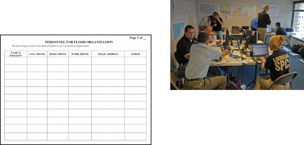
Flood Response Personnel. It is critical to
have a current phone list with home
numbers, cell phone numbers, and email
addresses for personnel involved in your
flood response plan, and update it regularly.
It is recommended that there be a process in
place for contacting flood response
personnel should an emergency occur or a
situation deteriorates. One way is to
establish a call tree where one person calls
3-5 people and they in turn each call 3-5
people. A form is included in Appendix B
that could be used as an example.
3
Dawson, Drew and Reid, Kathryn. “Sleep Deprivation on Driving Ability.” en.wikipedia.org. British Medical
Journal, 1997. Web. 29 October 2014.
Williamson AM, Feyer AM. “Sleep Deprivation on Driving Ability.” En Wikipedia.org. Occup Environ Med.
2000. Web. 29 October 2014
3
Personnel Plan. It is important to decide
who is in charge and has the authority to
make decisions or obligate the community
or tribe before the emotional and physical
strain of the flood event occurs. A National
Incident Management System (NIMS) -
compliant personnel plan should be
developed prior to flood season and be
endorsed by the local council. Topics
covered by the personnel plan should
include:
If you only have time to do
one thing for this chapter
on personnel, create a
current phone list.
Lessons Learned
:
“Researchers …reported that
sleep deprivation can have
some of the same hazardous
effects as being drunk.
People who drove after
being awake for 17–19 hours
performed worse than those
with a blood alcohol level of
.05 percent. Another study
suggested that performance
begins to degrade after 16
hours awake, and 21 hours
awake was equivalent to a
blood alcohol content of .08
percent.” -Wikipedia
3
12
• Designation of an Incident
Commander
• Incident command structure roles
and responsibilities
• Staffing levels and shifts
• Pay Schedule
• Family preparedness plans for
personnel
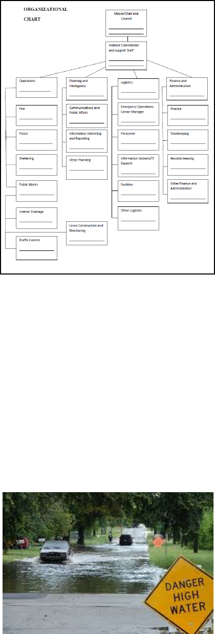
Key Personnel. The National Incident
Management System (NIMS), which was
developed by the Department of Homeland
Security to provide uniformity and
consistency across all levels of government
during a response, recommends the
following categories for a standardized
structure:
• Command Staff
• Operations
• Planning and Intelligence
• Logistics
• Finance and Administration
Each category will be discussed in greater
detail below. For all categories, staffing
levels will vary by community or tribe size
as well as complexity and magnitude of
event.
Photo: FEMA News Photo
Command Staff. This includes the
Incident Commander, or Flood Coordinator,
and any support staff. The Incident
Commander is usually appointed by the
Mayor or Chairperson and is the person in
charge of the flood fight including
recommending when mutual aid agreements
should be activated, and when evacuation is
necessary.
Operations. Some recommended positions
under Operations include:
• Fire and Police
• Sheltering
• Public Works
- Traffic Control
- Levee Construction and
Monitoring
- Interior Drainage
13
Planning and Intelligence. Some
recommended positions under Planning and
Intelligence include:
• Communications and Public Affairs
• Information Gathering and Reporting
Logistics. Recommended positions under
Logistics include:
• Emergency Operations Center
Manager
• Personnel
• Information Systems/IT Support
• Facilities
Finance and Administration.
Recommended positions under Finance and
Administration include:
• Finance
• Timekeeping
• Records keeping
Organizational Chart. A sample
organizational chart is included, recognizing
that many small communities or tribes may
have to double up on assignments or obtain
outside assistance. For instance, the finance
person may handle finance, timekeeping,
and record keeping. The traffic control may
be the National Guard.
Who Should Not Be Part of the Flood
Fight Personnel Plan. It has been
recommended that Mayors, Chairpersons,
City Clerks, Public Works Directors, and
Utility Superintendents be left to focus on
their normal responsibilities and not be
given additional responsibilities under the
flood response personnel plan. It is
recognized that they may be the most
knowledgeable people in the city, so a
realistic assessment should be made on a
case by case basis.
Photo: FEMA/Marvin Nauman

14
Second Shift and Back-up. It is important
that the personnel plan include staff for a
second shift and backups for key positions.
A 12-hour shift should be adhered to as
closely as possible with some overlap at
shift change. This will help to ensure people
are rested and have the capacity to make
good sound judgments. If the community
does not have staff to cover both shifts,
assistance should be requested from the
County, the State, or by activating mutual
aid agreements.
Pay for Assigned Positions. Consideration
should be given to determining a pay scale
for positions being filled by personnel not
currently on the City payroll, such as
volunteer firemen.
Family Preparedness Plans. Key
personnel should be encouraged to have a
plan in place for their own families. It is
difficult for flood fighters to focus on their
tasks if their own homes or families are in
need of protection.
List of Additional Resources:
• Case Study of Incident Command
Systems:
http://cra20.humansci.msstate.edu/Fr
om%20Forest%20Fires%20to%20K
atrina.pdf
• FEMA’s “Protect Your Property
from Flooding”:
http://www.fema.gov/media-
library/assets/documents/13261?id=3
262
Forms: See Appendix B.
• Personnel Phone List
• Call Tree
• Organizational Chart
CHECKLIST
Chapter 4 - Personnel
Current Contact
List
Call Tree
Organizational
Chart
Second Shift
Covered
Pay Approved
Family
Preparedness Plans

15
EMERGENCY ACTION
PLAN
CHAPTER 5
CONTACT LISTS
Contact List. The contact list includes
all the resources you may need outside
of your personnel phone list. It is
important that a community have a
comprehensive contact list and update it
on an annual basis. When creating the
list, consider how useful it will be if you
need to reach out on the Friday
afternoon of a holiday weekend. Include
website links. Include as many after-
hour numbers and back-up numbers as
possible.
Other Agencies. Your Contact List
should include other agencies and
organizations that you may deal with
during a flood event. It is recommended
that the contact list be grouped by
categories, such as:
• Federal water level and flood
forecast information (National
Weather Service, USGS gages)
• County (Emergency
Management)
• Mutual aid contacts
• State
o State Duty Officer
o Homeland
Security/Emergency
Management
o Department of Natural
Resources
o Department of
Transportation
o National Guard
If you only have time to
do one thing for this
chapter on contacts,
ask the County for their
list of contacts and add
your own to it.
Lessons Learned
: You
should not need to introduce
yourself to Agency
representatives when they
arrive at the Emergency
Operations Center (EOC).
Relationships should be
developed prior to the event
so you already have an
established working
relationship and an
understanding of what each
Agency is bringing to the
table.
- Advice given at an
Alabama Hurricane
Conference.
16
• Other Federal
o Corps of Engineers
o FEMA
o NWS
o USGS
o HUD
o NRCS
o BIA
• Utility Companies
o Electric
o Gas
o Sewer and Water (if
different from City)
Photo: U.S. Army Corps of Engineers
• Other
o Red Cross
o Salvation Army
o Volunteer Organizations
o Ham radio operators
o Local Churches
Photo: FEMA News Photo
List of Additional Resources
• Corps of Engineers:
http://www.mvp.usace.army.mil/Mis
sions/EmergencyManagement.aspx
• USGS:
http://waterdata.usgs.gov/usa/nwis/rt
• NWS:
http://water.weather.gov/ahps/foreca
sts.php
• General:
http://www.ready.gov/
• FEMA:
http://www.fema.gov/
Forms: See Appendix B.
• Outside Contacts
17
CHECKLIST
Chapter 5 - Contacts
Points of Contact for:
Water levels
County EOC
State EOC
Other State
Federal Agencies
Utilities
Volunteer
Organizations

18
EMERGENCY ACTION
PLAN
CHAPTER 6
FLOOD ELEVATIONS,
MAPPING,
AND HISTORY
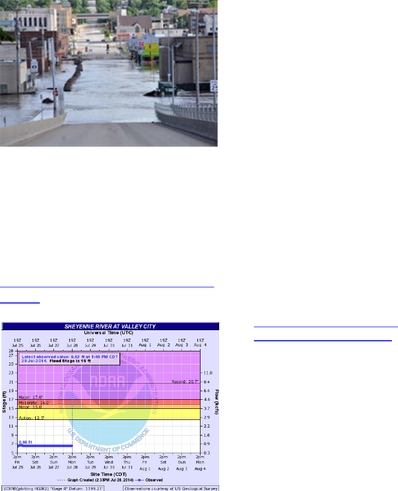
Flood Gages. If you do not have the good
luck of having a river gage right in your
community or reservation, the first thing to
do is identify the river gage nearest you or
the closest upstream gage. This gage will be
used to track rising river levels and what
actions are needed in your area.
Stages vs. Elevation. River gages are
sometimes given in stages instead of
elevations, so it is important to know how
they are related, especially if you have
surveyors taking elevations of levees or low-
lying areas in your community. The
National Weather Service Advanced
Hydrologic Prediction Service websites will
often list the stages at which infrastructure
will begin to be impacted. If this is not
available, this is information you will need
to compile locally. The National Weather
Service website includes information on the
elevation of flood stages under the
“metadata” tab. The metadata tab appears
once you zoom in and select the hydrograph
page for your desired gage location. Stage
is converted to elevation by adding the gage
zero listed in the metadata tab. Note that the
gage zero elevation listed on this tab is in
NGVD 1929. If necessary, it can be
converted to NAVD 1988 as described in
the next section. See the “About This
Location” table included in the
“Hydrograph” tab for current information.
If you only have time to do
one thing for this chapter
on flood elevations,
identify the nearest river
gage and know how to find
it on
http://water.weather.gov/a
hps/forecasts.php.
Lessons Learned
:
The phrase “100-year flood”
is frequently used to
describe a large event. It is
more accurate to think of it
as event having a 1 in 100
probability of occurring in
any given year. This is also
known as the 1% annual
chance flood. Each year is
independent, so even if you
recently experienced a “100-
year flood”, it could flood
again this year to a similar
level.
BE PREPARED!
There is a 26% chance a 100-
year flood will occur over the
course of a 30-year mortgage.
19
Photo: U.S. Army Corps of Engineers
* If any National Weather Service
information appears outdated or
incorrect for your community, you may
find your local NWS hydrologic contact
at:
https://www.weather.gov/water/hydrologic_
contacts
Elevation Datums. Datums are reference
points used in surveying. When dealing
with elevations of levees or water, be aware
there are different vertical elevation datums.
Make sure the forecast flood elevation and
the surveyed ground elevations in your
community are being compared in the same
datum. For the most part there is the
National Geodetic Vertical Datum of 1929
(NGVD29) and the North American Vertical
Datum of 1988 (NAVD88). Sometimes
there can be more than a foot difference
between the two.
Different federal agencies may use different
datums. For instance, the Corps of
Engineers built the embankments around the
City of Devils Lake, ND using NAVD88,
but the USGS gages for lake levels are in
NGVD29. The link below provides a utility
to convert NGVD 1929 elevations to NAVD
1988 if necessary. Latitude and longitude,
which can be obtained from Google Earth or
Google Earth Pro, are required for the
desired location. In addition, elevations
must be entered as XXX.XX FT for a
conversion in feet.
http://www.ngs.noaa.gov/cgi-
bin/VERTCON/vert_con.prl
River Slope or Hydraulic Profile. Another
elevation consideration is that rivers have
slope and elevations decrease as you move
downstream with the flow. It is important to
recognize this slope if you are using a gage
not near your location or even to know the
slope from one end of your location to the
other. As an example, during the Minot, ND
flood of 2011, there was over 14 feet of
slope on the river from the north end to the
south end of the City, based on the slope of
the river and the hydraulic losses along the
river and across bridges (water backing up
behind the bridges). The actual water
surface matters because the levees upstream
of the gage reading will need to be higher
and the levees downstream of the gage
reading can be lower.
20
It is recommended that you have a hydraulic
profile developed for your location for
future reference. Profiles may be available
if a detailed flood insurance study has been
developed for your location or county as
described in the next section. Or it may
require the involvement of a consultant or a
state or federal agency. Start with your
county or state emergency management
contact if you are in need of a hydraulic
profile.
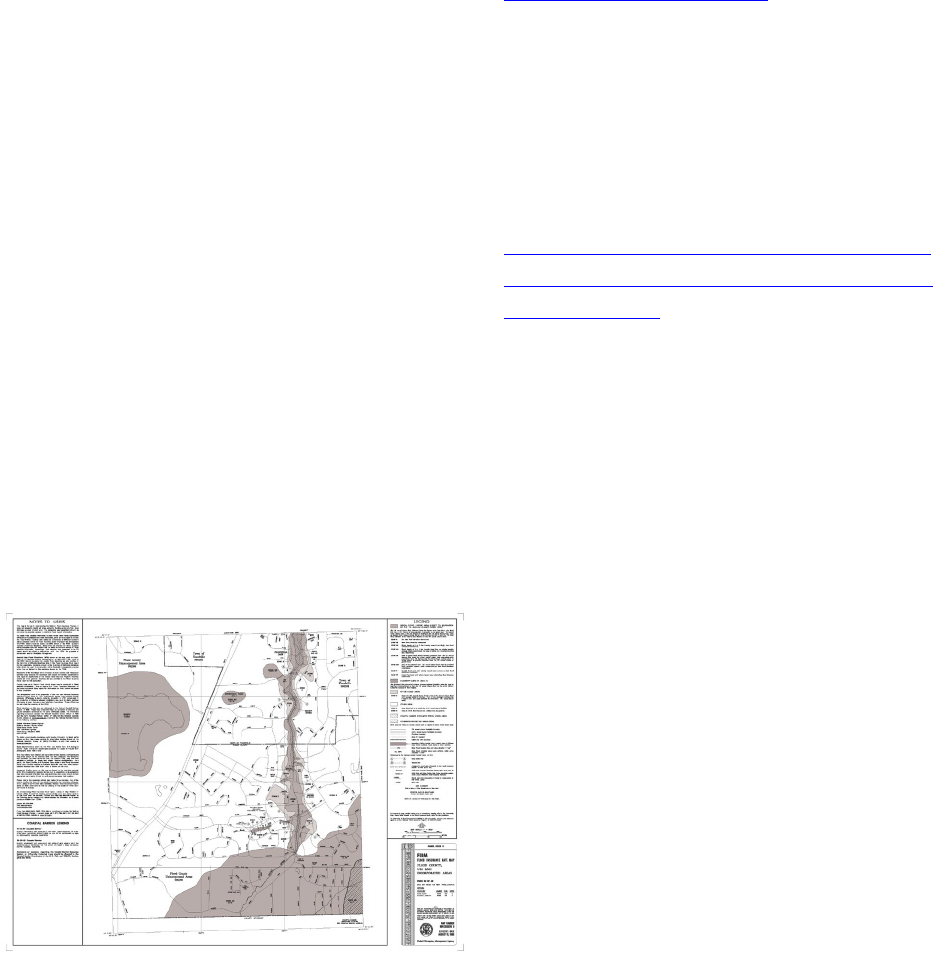
Floodplain Mapping and Profiles. If your
community, tribe, or county participates in
FEMA’s flood insurance program, you will
likely have flood insurance rate maps
(FIRMs) that identify the floodway and
floodplain for the 1% (100-year) and 0.2%
(500-year) annual chance floods. The flood
insurance study report will typically include
profiles through your community or county
for the 10% (10-year), 2% (50-year), 1%
(100-year) and 0.2% (500-year) flood
events. Your local floodplain administrator
may have copies of the report and maps.
PDF files of older studies and maps are
available at no charge online from the
FEMA Map Service Center at the link
below. Note that older studies are generally
in the NGVD 1929 vertical datum.
https://msc.fema.gov/portal
If the flood insurance study was developed
or updated recently, digital GIS-based maps
will be available at the link below. These
newer maps are generally in the NAVD
1988 vertical datum.
http://fema.maps.arcgis.com/home/webmap/
viewer.html?webmap=cbe088e7c8704464aa
0fc34eb99e7f30
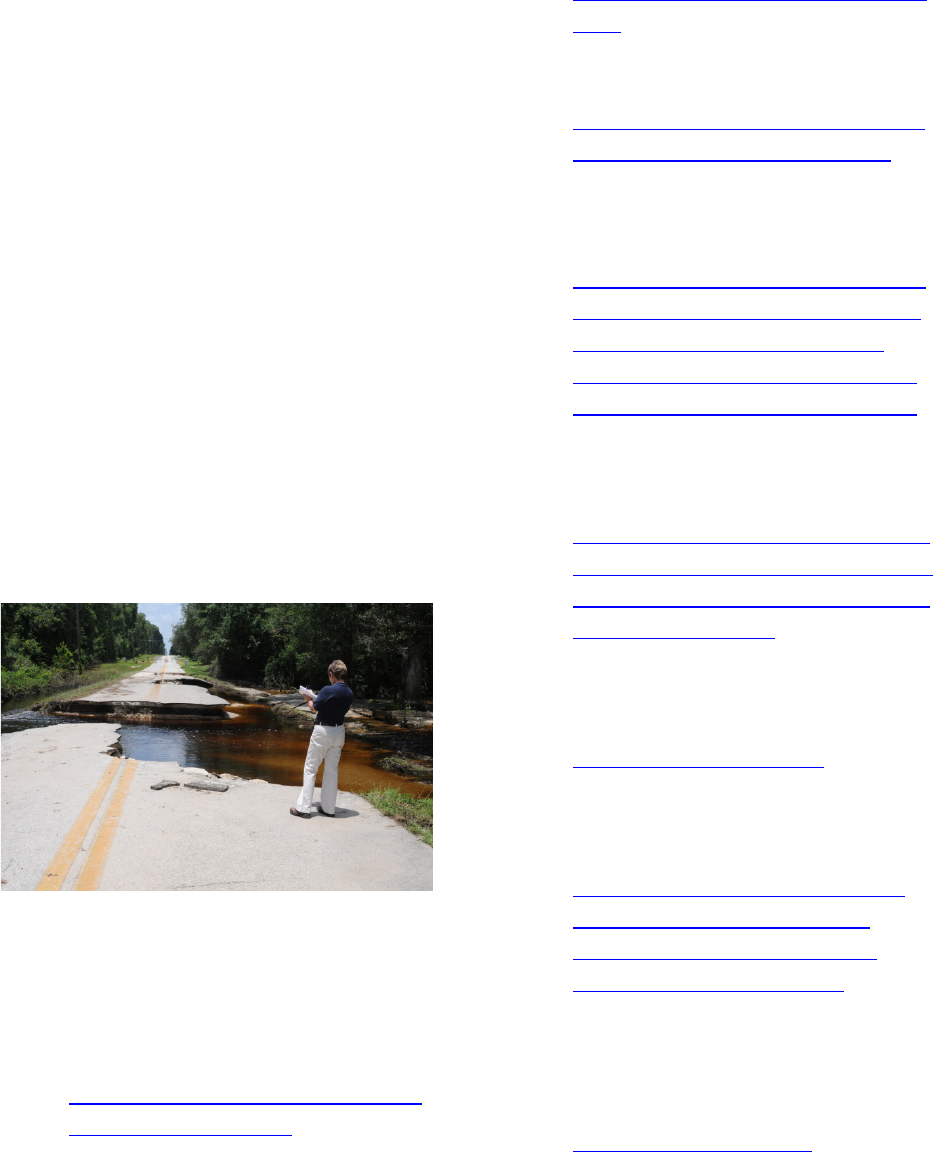
It is important that low lying areas and
roadways that could be subject to flooding
be identified so the earliest impacted areas
can be evacuated first.
Flood Inundation Maps. If your
community is protected by levees or
floodwalls, mapping should include the
areas behind the levee that would be
inundated if the levees or floodwalls were
overtopped or damaged.
Topographical Mapping. If you do not
have staff that works with GIS (Geographic
Information Systems) or that can create
mapping, it is worth hiring someone to
provide you with a map with elevations and
contours identified.
21
Some states have developed GIS topography
for all or portions of the state which can be
used to determine elevations and contours in
your location or county. In states where this
has been done, counties which have a GIS
mapping website typically include the
topography as a layer. For instance, the
state of Minnesota has developed statewide
topography which is a layer in their GIS
viewer. If you zoom in to your location or
county, first ten-foot interval contours will
be displayed and if you zoom in closer two
foot interval contours will display. This GIS
viewer also allows you to obtain point
elevations or a profile along a line that you
enter. The contours and digital elevation
model that the contours are based on can be
downloaded and used in a local GIS map.
The link to the Minnesota topography
viewer tool can be found at:
http://www.dnr.state.mn.us/maps/mntopo/in
dex.html
History. After a flood it is important to
survey high water marks so there is a history
of what areas are impacted by the flooding.
If the last flood occurred sometime in the
past, it is important to capture and document
personal knowledge of past floods. Some
important elevations to include:
• Top of levees both upstream and
downstream and key points in-
between
• Lower chords (bottoms) of bridges
• Inverts of any pipes that discharge
into the river
• Low areas of main roadways and
evacuation routes
• The lowest flood elevation of critical
facilities like rest homes
• Elevations at which flood fighting
steps should be taken.
The elevations at which flood fighting steps
should be taken will be discussed in the next
chapter.
List of Additional Resources:
• NWS River Gages:
http://water.weather.gov/ahps/foreca
sts.php
• NWS Hydrologic Local Contacts:
http://www.nws.noaa.gov/om/water/
hydromap.htm
• Converting NGVD 1929 elevations
to NAVD 1988:
https://www.ngs.noaa.gov/cgi-
bin/VERTCON/vert_con.prl

22
•
FEMA Map Service Center:
https://msc.fema.gov/portal
• FEMA Digital Flood Insurance
Maps:
http://fema.maps.arcgis.com/home/
webmap/viewer.html?webmap=cbe0
88e7c8704464aa0fc34eb99e7f30
• The link to Minnesota topography
can be found at:
http://www.dnr.state.mn.us/maps/m
ntopo/index.html
• Orange County CA Flood fighting
advice:
http://ocflood.com/safety/fight/
Forms: None
CHECKLIST
Chapter 6 - Flood
Identify nearest
river gage
Relate river stage to
levee elevation
Hydraulic profile
Map of floodplain
Inundation map
Elevations of
impacts

23
EMERGENCY ACTION
PLAN
CHAPTER 7
TASKS AND PRIORITIZED
ACTIONS
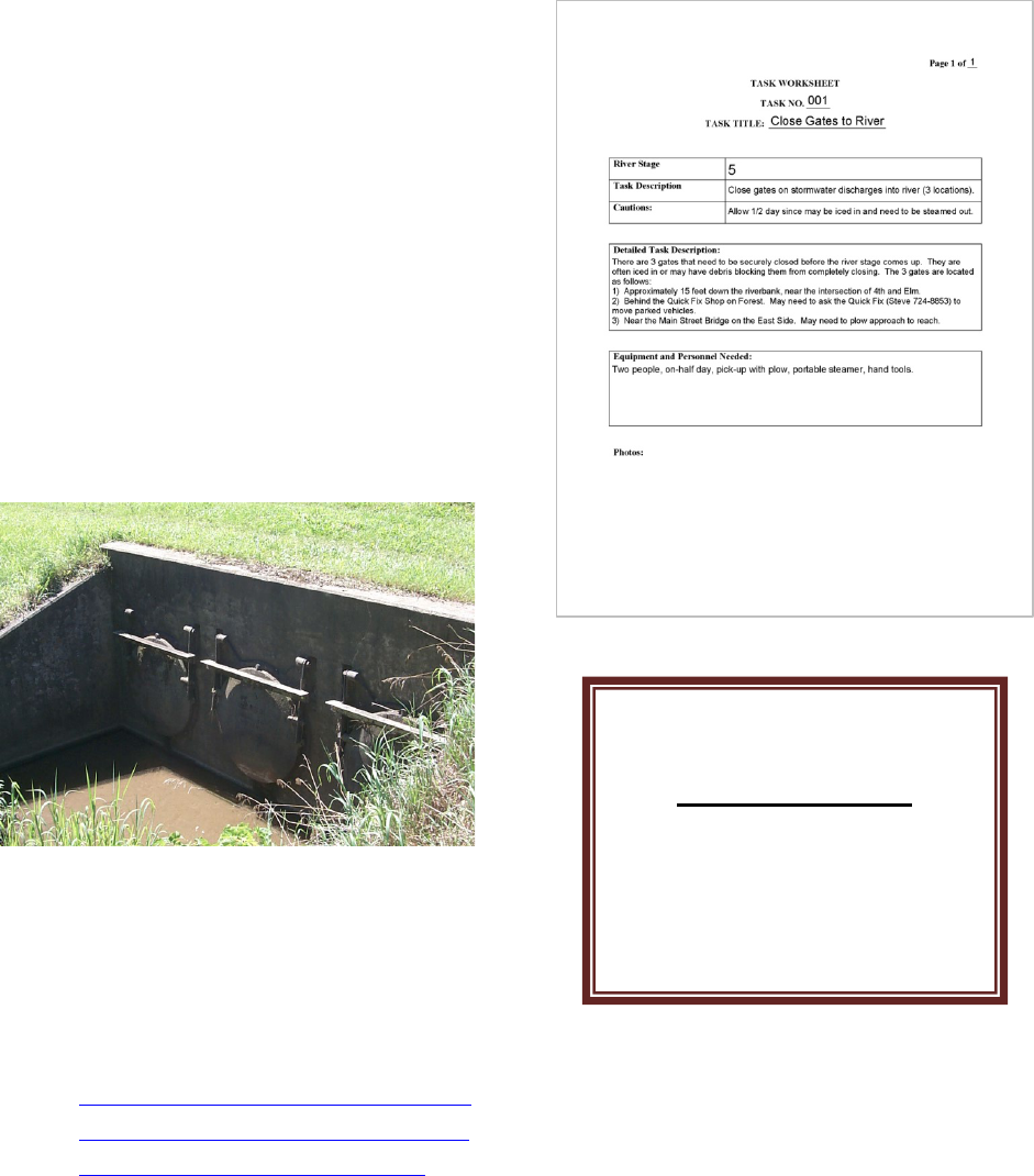
Prioritized Tasks/Actions to be Taken.
This chapter could be considered the most
important chapter of the entire plan in the
execution of a successful flood fight. Some
of the tasks could include:
• Locations of temporary pumping
• Gatewell closures
• Activation of pump stations
• Sewer lift stations to be sandbagged
• Road closures and detour signage
• Sandbags and temporary levees
• Bridge closures if approaches low or
low chords could become
submerged.
4
Allemeier, Kurt. “Davenport cranks up flood fight.” qctimes.com. Quad City Times, 18 April 2103. Web. 29
October 2014.
4
Individual Task Worksheet. For each item
that is to be completed, a separate task
worksheet should be created. A sample
form is included in Appendix B. Your
public works director may have this all in
If you only have time to do
one thing for this chapter
on tasks, brainstorm a list
of tasks (like storm water
plugs) that needed to be
accomplished in the last
flood.
Lessons Learned
:
“Heavy rains and a rapidly
rising Mississippi River
caused headaches but didn't
divert Davenport employees
from the city's flood plan.
The city has a 400-step plan
to fight flooding on the
Mississippi River, now
projected to reach a crest of
20.2 feet Sunday, more than
5 feet above the 15-foot
flood stage in the Quad-
Cities.”
-Excerpt from 2013 Quad
City Times story by Kurt
Allemeier
4
24
his head, but now is the time to get it on
paper. Each task should be described in
enough detail that someone who has not
accomplished it before can do so based on the
information provided. Some of the items to be
listed include:
• Tools required
• Materials needed to complete the
task and their locations
• Estimated time to complete
• Estimated labor
• Photos, if helpful
• Flood stage at which the task
needs to be completed
• Helpful hints or lessons learned
from previous events.
Photo: U.S. Army Corps of Engineers
List of Additional Resources:
• Corps of Engineers St. Paul District
Flood Manual:
www.mvp.usace.army.mil/Portals/57
/docs/Operations%20Center/MVP_F
lood_Fight_Handbook_2016.pdf
Forms:
• Task summary list by elevation
• Task worksheet
CHECKLIST
Chapter 7 - Tasks
Task list
Complete task
worksheets

25
EMERGENCY ACTION
PLAN
CHAPTER 8
EMERGENCY SHELTERS
Objective. In this chapter the basics of
identifying emergency shelters are outlined.
It is important that at least one location be
identified as a shelter prior to a flood event,
and that people know where to go in the
event the sirens go off or an evacuation is
declared.
Photo: FEMA/Andrea Booher
Resources. The Red Cross, the Salvation
Army, and other organizations are often
available to help establish shelters. Pre-
disaster coordination is critical. Initially the
local community may be the only resource
available until reinforcements arrive.
Lesson Learned:
Communities that have
required sheltering report
that if there is a chance a
shelter may be needed, it
cannot be started too soon.
A plan should be in place in
case outside resources like
the Red Cross are
overwhelmed and cannot
respond immediately.
If you only have time
to do one thing for this
chapter on shelters,
answer this: Where
will you direct people
to go when the sirens
go off?
26
Short-Term and Long-Term Sheltering.
Both a short-term location and a longer term
location should be considered. For longer
term use, a location for people to shelter
overnight should be identified. In some
cases, the best shelter might be outside the
flooding community.
Considerations. Possible facilities include
schools, churches, and community centers.
Schools make good shelters, but can result
in conflicts as the return of classes can be
the first step in the return to normalcy after a
flood. Some considerations include:
• The elevation of the facility
especially if it is located behind a
levee
• Handicap accessibility
• Basic fire protection like fire
extinguishers
• Allow for approximately 20-40
square feet per person
• Have a minimum of 1 toilet for
every 40 people
• Ideally showers and kitchens are
desirable, but not critical.
• The facility should not be
susceptible to sewer and water
interruptions, and should have a
back-up generator.
Photo: FEMA/David Saville
Services. Evacuees in a shelter will need a
full range of services that could include
meals, bedding, clothing, crisis counseling,
medical attention, mental health services,
child care, transportation, phone, and
internet access. The elderly and disabled
may have special needs. Registration of all
evacuees should be required to ensure the
security of the site.
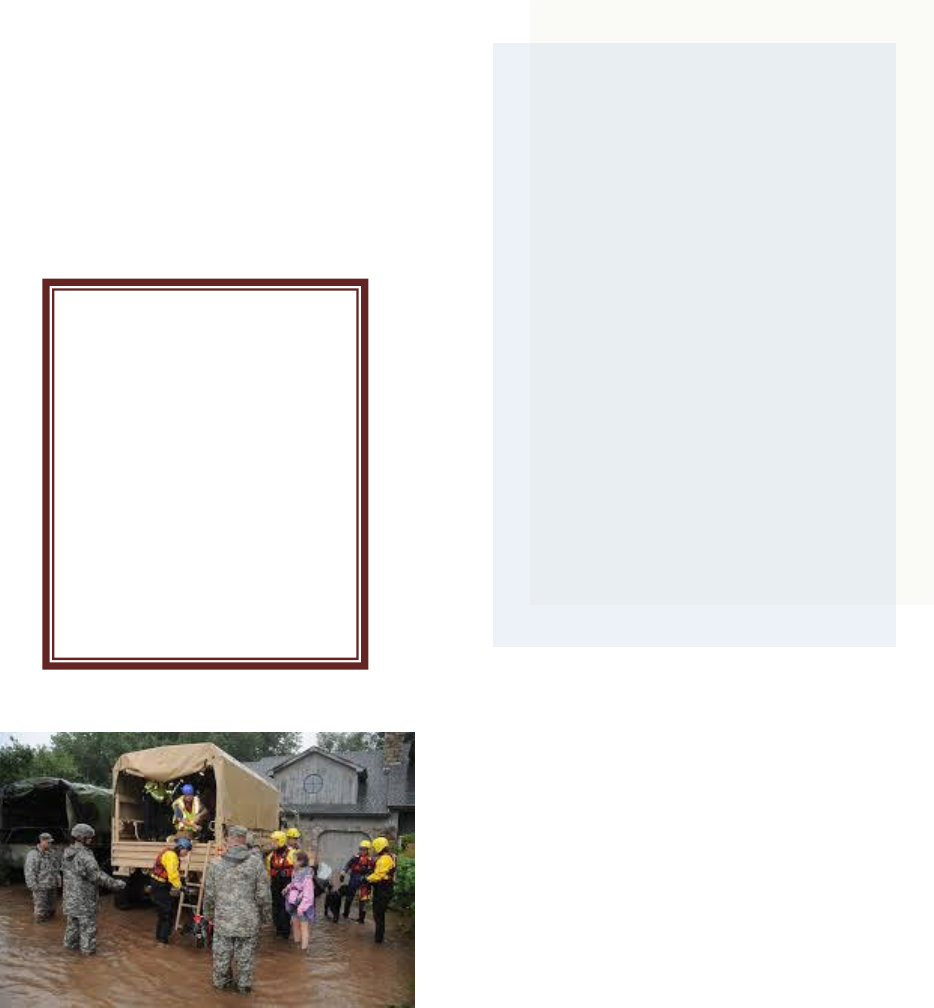
Pets. Since Hurricane Katrina, the
importance of allowing for the sheltering of
pets has been realized. Many people would
risk jeopardizing their own lives rather than
leaving their pets behind. Pets need to be
housed in an area separate from people,
either off-site or a separate part of the
facility. Except for guide dogs, pets should
not be allowed to mingle with evacuees due
to potential allergy issues, bite risks, and
other disruptive effects.

27
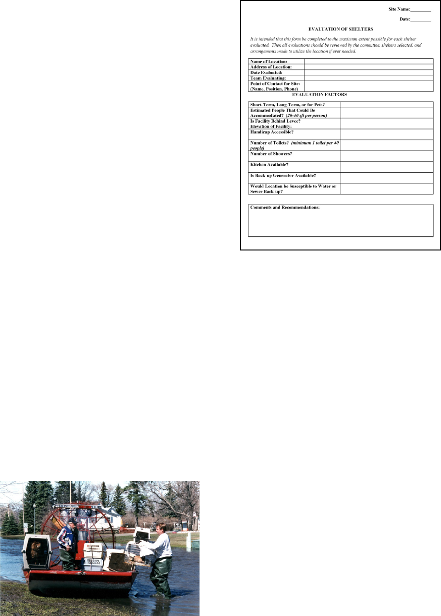
More Details. A form for evaluating
different options for shelters is included in
Appendix B. Links to some examples of
other sheltering plans are listed below and
included in Appendix A.
List of Additional Resources:
• Shelter Guidance and Shelter Staff
Matrix:
http://nationalmasscarestrategy.org/s
heltering/
• Red Cross Shelters – Alameda
County, CA:
https://www.cdc.gov/nceh/ehs/Docs/
Guide_for_Local_Jurisdictions_Care
_and_Shelter_Planning.pdf
• Pet Evacuation Guidelines from
FEMA:
www.tahc.state.tx.us/emergency/FE
MA_CPG302_HouseholdPets.pdf
• Livestock Evacuation Guidelines
from the University of Vermont:
http://www.uvm.edu/~ascibios/?Page
=Emergency/Disaster_Planning_for_
Livestock.html&SM=submenuemerg
ency.html
• Animal Shelter Operations: Pet
Friendly Shelters:
file:///C:/Users/b6ecbmh7/Download
s/LLIS%20Pet%20Friendly%20Shelt
er%20Best%20Practices%20Docum
ent.pdf
• ASCE Article on lessons learned :
“Assessment of Public Shelter User’
Satisfaction: Lessons learned from
South-Central Texas Flood:
https://ascelibrary.org/doi/pdf/10.106
1/%28ASCE%29NH.1527-
6996.0000055
Forms.
• Evaluation of shelters
• Summary of shelters
CHECKLIST
Chapter 8 - Shelter
Identify potential
sites
Determine
elevations of sites
Contact facility
owners and
complete
evaluations
Establish contact
with local Red Cross
Agree on short and
long term sheltering
sites.
28
EMERGENCY ACTION
PLAN
CHAPTER 9
EVACUATION
Photo: U.S. Department of Defense/Sgt. Joseph
VonNida
Evacuation Authority. All states give
Governors the authority to order
evacuations. However, the way in which
that authority is delegated down to counties
and cities varies by state. Local ordinances
usually specify that the County Emergency
Manager has the authority. It is important
that the person with the authority be firmly
established before an emergency event and
not subject to debate during the stress of the
flood event.
Voluntary vs. Mandatory Evacuations.
Much has been written on the difference
between voluntary and mandatory
evacuations. Some states and counties
declare a mandatory evacuation to
emphasize the seriousness of the evacuation.
Residents may be told that rescue resources
will not be available if they do not evacuate
or they will be responsible for the expense.
Check your state and local laws to determine
what types of evacuations are legal to order.
Lesson Learned: During
a flood, a small community
identified a potential levee
break and the sirens were
activated at 6 AM in the
morning. People were
directed to seek high ground
and told to go to the ball
field. Unfortunately this was
the same location that was
being used as a borrow pit
for the levee material.
Mixing fleeing residents and
dump trucks hauling clay to
the levees made for an
unsafe situation.
If you only have time
to do one thing for this
chapter on
evacuation, answer
this: Who has the
authority to make the
decision to evacuate?
29
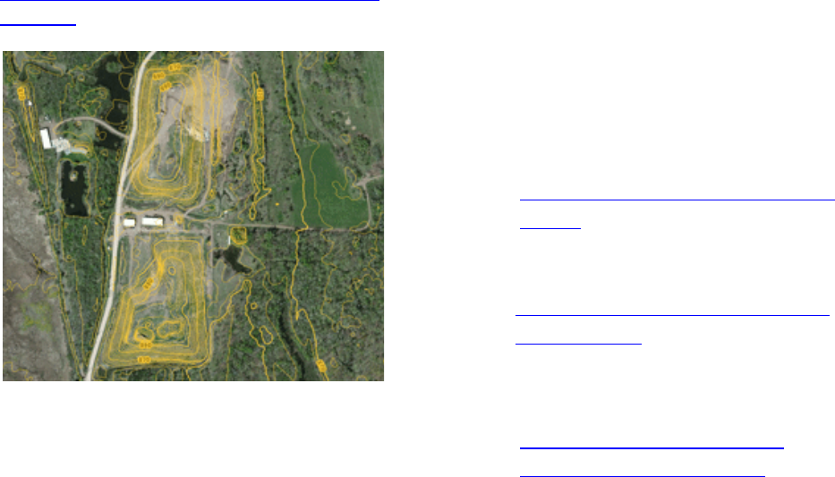
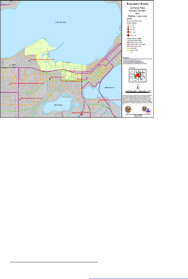
Evacuation Zones. Except for possibly the
smallest of communities, it is recommended
that each community have a map divided
into zones based on elevations of the homes,
elevation of the roads, and locations of levee
construction. This map should be well
publicized so that when an evacuation is
required, residents can quickly identify their
zone. This same map can be used to allow
people to return to their homes.
5
Establishing Evacuation Zones. The flood
plain map from a flood insurance study is a
good tool to begin with. Start at the river
and divide the area using natural
neighborhood divisions, considering the risk
of flooding for each area. Depending on the
number of homes involved and the
elevations involved, you may want to
include the homes adjacent to the river in
one zone and the next band of homes in a
separate zone. Keep in mind that low-lying
areas protected by levees could be flooded if
5
Dane County Emergency Management. “Evacuation Routes-Campus Area Primary Routes and Shelter Locations”.
Scale Not Given. January 2008. https://em.countyofdane.com/evacuation
. Dane County Emergency Management.
In: “Dane County/Madison Metropolitan Area Evacuation Plan – Appendix F”.
there is a breech or flooded from interior
drainage if storm sewer pipes to the river
have been plugged and pumping has not
been able to keep up with rain or snowmelt.
An example is shown on this page and
included in a larger size in Appendix B.
Routes and Elevations. Based on past
experience and also by reviewing a map
with elevations, any low lying areas that
may flood should be identified and taken
into consideration with evacuation routes.
Often bridges are high enough, but the
approaches are low and flood out first. All
routes need to be evaluated for viability
considering past and expected future flood
levels. The public needs to be made aware
of the routes, and if their part of town is
assigned to any particular route.
Traffic Control and Safety. Prior to
issuing an evacuation order, the routes
should be confirmed as passable and traffic
control should be assigned and in place.
Public Works or the Department of
Transportation should be coordinated with
to determine where barricades may be
required. For densely populated
communities, contraflow should be
considered to expedite the evacuation
process. Contraflow involves using all lanes
of traffic for the evacuation route. This has
been used successfully in the past but needs
to be planned and coordinated well in
advance.
30
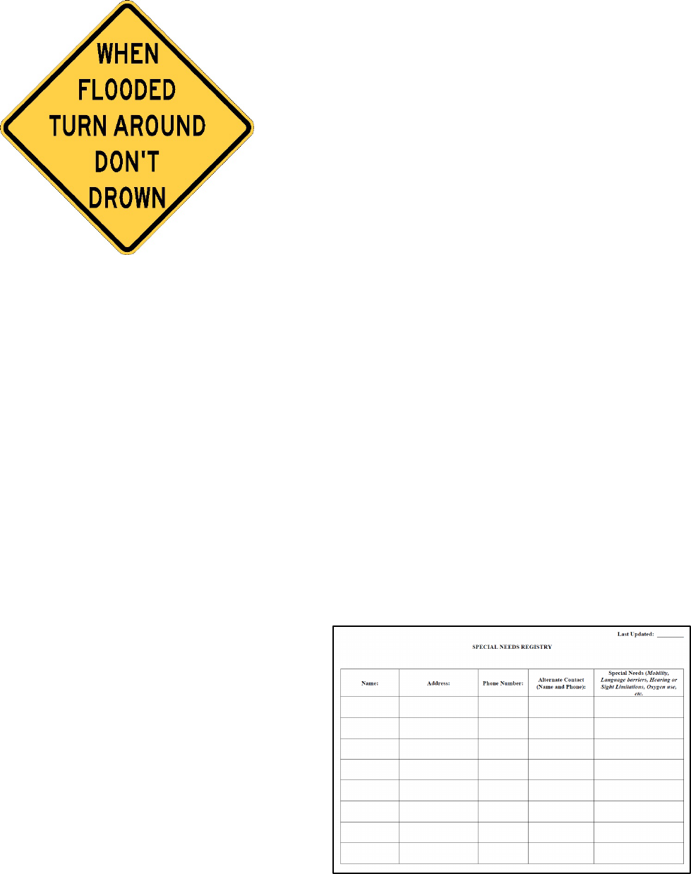
People should be reminded to not drive
through flooded roadways. The National
Weather Service has a campaign called
“Turn Around, Don’t Drown” to warn
people against walking or driving through
water. Materials for educating the public
and recommended signage are available at
their website (See the list at the end of the
chapter). They report that six inches of
water can make a car unstable or stall.
Twelve inches can make a car float. You
should also verify that evacuation routes will
not interfere with construction traffic.
When to Evacuate. As difficult as an
evacuation call is to make, it is even more
difficult if made late. Every situation is
unique and the balance between ordering an
early evacuation that could cause confusion
and hysteria with ordering an evacuation too
late and having people in harm’s way must
be weighed. Have the discussion with the
flood team early, even prior to flooding and
error on the side of allowing more time for
evacuation.
Notifying the Public. An evacuation notice
can be issued in a number of ways – the
more used the better. These include:
• Press releases to all forms of media
including radio and television
• Social media including Facebook,
Twitter, and Snapchat
• Reverse 911 (See Chapter 13
regarding Communications)
• Fire and police vehicle loudspeaker
systems
• Door to door notification
• Sirens.
Special Needs Registration. A further
refinement of the evacuation plan would be
to encourage special needs or vulnerable
populations to register so emergency
management would be aware of their special
requirements during an evacuation. It would
not be a guarantee that they would have
assistance in evacuating and they should still
make their own arrangements if at all
possible. It may be desirable to have
individuals sign a waiver so there is no
misunderstanding. A special needs
registration would require annual updating
and the information would need to be treated
as medical records or protected information.

31
List of Additional Resources:
• Vulnerable Residents Registration:
https://webapps4.broward.org/Vulner
ableRegistry/Welcome.aspx
• City of Chicago Registration:
https://webapps1.cityofchicago.org/v
olunteerregistry/checkDisclaimer.do
• Health Affairs Evacuation – the
challenge of mandatory evacuations:
https://www.healthaffairs.org/doi/pdf
/10.1377/hlthaff.25.4.958
• California information on
evacuations:
https://www.caloes.ca.gov/PlanningP
reparednessSite/Documents/02%20F
EAT%20LegalGuidelinesforFloodEv
acuation(FEAT%20doc).pdf
• National Weather Service Campaign
“Turn Around, Don’t Drown”:
https://www.weather.gov/safety/floo
d-turn-around-dont-drown
Forms.
• Special Needs Registry
• Special Needs Registry Waiver
• Evacuation zone example
CHECKLIST
Chapter 9 - Evacuation
Establish who has
the authority
Determine how the
decision will be
made
Evacuation zones
Evacuation routes
Traffic control plan
Public notification
Special Needs
Registration.

32
EMERGENCY ACTION
PLAN
CHAPTER 10
UTILITIES
Overview. During a flood emergency,
many utilities may be affected. It is crucial
to understand what utilities are in your area
and how to coordinate with the providers.
Points of Contact. The most critical item in
this chapter is to have a good current list of
all utility providers with points of contact
and after hour phone numbers. Some
companies have complex business
organizations with subsidiaries and it can be
difficult to track down who will be
responsible in an emergency. Others may
have offices that are located hours away or
in the next state. Identifying the proper
process for contacting each provider as part
of your emergency action plan can save
undue frustration during the flood.
Photo: U.S. Army Corps of Engineers
Lesson Learned:
During
the Minot flood of 2011, the
raging river put so much
pressure on the storm water
plugs that several were
blown out, causing the City
to flood from the inside.
Massive ring levees, around
multiple homes and as high
as the rooftops, were
required to equalize the
pressure with the river. The
extreme amount of water
pressure that might be
encountered needs to be
considered during the early
process of plugging storm
sewers that discharge to the
river.
If you only have time
to do one thing for this
chapter on utilities,
prepare a list of utility
providers, current
points of contact, and
after-hours phone
numbers.
33
Coordination with Utility Providers. In
most events your primary coordination will
be to notify utilities of flooding. But you
may need to work closely with them if levee
construction conflicts with their lines. There
may need to be priorities established. And
once the threat of flooding has passed, there
will be the coordination of any repairs and
getting services restored as quickly as
possible.
Photo: FEMA/Jocelyn Augustino
Electrical Service. Without electrical
power, residents cannot run their sump
pumps. City pump stations and lift stations
may also be impacted. Part of this
emergency action plan should include
discussions with the power company
regarding the elevations of transfer stations
or substations and their plan for maintaining
or restoring services during a flood.
Generators. Although there is a cost
associated with maintaining generators in
working order, investing in back-up
generators is strongly recommended.
Electrical power is critical to most
operations but may not be available even if
the facility is not directly impacted by
floodwaters. Back-up generators are usually
the solution to the continuing operation of
most facilities. But it is not just a simple
matter of checking the box. Some questions
that should be asked and planned for
include:
• Is there a high level of confidence
that the generator can perform for
multiple days, not just a few hours?
• Is the expected load on the generator
realistic? Has it been updated
recently?
• Are on-site staff familiar with the
operation and trouble shooting of the
generator? Many facilities may
contract out the maintenance and
those personnel may not be
available.
• Is there a realistic plan for refueling
the generators? Will the fuel truck
be cut off from the facility by the
floodwaters?
Gas Service. Broken gas lines can result in
fires in the midst of flooding. A discussion
with the gas company should include the
location of shut off valves and which lines
may be impacted by floodwaters.
Photo: FEMA/Wendell Davis Jr.
Sanitary Sewer. Floodwaters or even high
ground water can significantly increase the
amount of infiltration into sewer pipes and
overwhelm lift stations and even the sewage
34
treatment plant. The elevation of all lift
stations should be known, including the
elevations of the access. If the system is
overwhelmed it may be necessary to get
permission from the Health Department to
bypass treatment and discharge directly into
the river. If this happens, restrictions should
be placed on residents to minimize use and
porta-potties should be brought in. As part
of on-going mitigation, lines known to be
vulnerable should be upgraded as part of a
regular capital improvements program.
Water Lines. Crushed or damaged water
lines can result in leakage to the point of
pressure loss. This creates a very dangerous
firefighting situation. Having a good map of
shut-off valves and the location of water
lines in the floodway should be part of this
plan.
Photo: FEMA/Steve Zumwalt
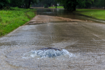
Storm Water. Flooding from improperly
plugged storm water lines connected to the
river can be one of the biggest threats to a
successful flood fight. Lines considered
successfully plugged can be compromised
by the high pressure of the rising river
levels. Once compromised, the area will
need to be ringed with sandbags or clay so
the water can seek its own level and be
stabilized. If all discharge lines to the river
have been successfully plugged, then this
also means all interior drainage must be
pumped over the levees into the river. The
emergency action plan should include a plan
for identifying locations to be pumped, the
amount of pumping anticipated, and other
details such as type of pumps, length of hose
needed, and where the water is to be
pumped.
Telephone Companies. Coordinate with
local cell phone providers ahead of time and
understand the resources they may be able to
provide in the event of flooding. Some
companies have portable units that can be
brought in if towers are damaged or
overwhelmed.
List of Additional Resources:
• None
Forms.
• No separate forms for this chapter –
utility contacts should be included on
the main contacts list.

35
CHECKLIST
Chapter 10 - Utilities
List of utility points of
contact
Discussions with utility
companies regarding
their plan during
emergencies
Back-up generators
Plan for sanitary sewer
infiltration
Maps of water shut-off
valves
Plan for plugging storm
water outlets
Plan for pumping interior
drainage
Back-up for cell phone
service.

36
EMERGENCY ACTION
PLAN
CHAPTER 11
CRITICAL FACILITIES
Definition. Critical Facilities are defined as
facilities from which essential services and
functions for victim survival, continuation of
public safety actions, and disaster recovery
are provided. Examples would include:
• Emergency operations center
• Fire stations
• Law enforcement centers
• Hospitals
• Nursing Homes
• Water treatment plants and public
drinking water supplies
• Sewer and wastewater facilities
• Schools
• Shelters
6
Brunkard, Joan and Namulanda, Gonza and Ratard, Raoult. “Hurricane Katrina Deaths, Louisiana, 2005.”
dhh.louisiana.gov. Medicine and Public Health Preparedness Journal, 28 August 2008. Web. 29 October 2014.
• Power plants and substations
• Sites with hazardous materials
6
At-Risk Critical Facilities. Some critical
facilities may depend on services or utilities
located within the flood plain, even if the
critical facility itself lies outside the flood
plain. During a flood event, those services
or utilities may become unavailable, and a
plan must be in place to provide another
source of power, water, etc. to the affected
critical facility. For example, if a nursing
home receives electric power from a
substation within the flood plain, a plan
must be in place to provide auxiliary power
in the event the substation is flooded.
If you only have time
to do one thing for this
chapter on critical
facilities: Make a list
of critical facilities in
your area with an
after hour’s point of
contact for each.
Lessons Learned:
Over 49
percent of the deaths following
Hurricane Katrina were persons
over 75 years old. “Future
disaster preparedness efforts
must focus on evacuating and
caring for vulnerable
populations, including those in
hospitals, long term care
facilities, and personal
residences.”
Article by
Brunkard, Namulanda, and
Ratard for Disaster Medicine
and Public Health
Preparedness.
6

37
Individual Plans for Community
Facilities. Facilities under the direct control
of the community or tribe, such as fire
stations and law enforcement centers should
have individual plans that address alternate
work sites. It is recommended that the
community or tribe have a continuity of
operations plan that could include the plans
for these individual critical facilities.
Individual Plans for Facilities Under the
Control of Other Agencies. Other facilities
such as hospitals and schools should have
their own plans and take into consideration
that resources in the region may be limited.
Photo: U.S. Army Corps of Engineers
Alternate Site for the Emergency
Operation Center. An alternate site for the
emergency operation center is recommended
since the primary facility could be impacted
by the disaster just as other structures.
Considerations include good communication
equipment, work stations, a generator for
back-up power, and facilities for meal
preparation and cots if necessary.
Unique Facilities. Any unique properties
should also be encouraged to have an
individual plan. As an example, in recent
years there have been instances of local zoos
that needed to be evacuated due to flooding.
Don’t Underestimate Resources Needed.
During the Minot, ND Flood of 2011, the
decision was made to evacuate a nursing
home. Two hundred and thirty-one
residents were relocated to 26 other facilities
or to family members. A North Dakota
Department of Health press release reported
that they were deploying transportation
assets to include one stretcher bus, five
wheelchair buses and 17 wheelchair vans.
Care should be taken to not underestimate
the resources that may be required.
Generators. Electrical power is critical to
most operations but may not be available
even if the facility is not directly impacted
by floodwaters. Back-up generators are
discussed in more detail under the utilities
sections. The Corps of Engineers hosts an
online database of power requirements for
critical facilities. Critical facility owners
can register and submit their facility
requirements. The link to this database is
included under “Links to Additional
Resources”.
Photo: U.S. Army Corps of Engineers

38
List of Additional Resources:
• Emergency Power Facility
Assessment Tool:
https://epfat.usace.army.mil/
• State of Florida Standard Operating
Procedures for Critical Facilities:
http://www.training.fema.gov/EMIW
eb/edu/docs/HistoricalInterest/Florid
a%20Division%20of%20EM%20-
%20CFI-
RSFI,%20Standard%20Operating%2
0Guidel.doc
Forms.
• List of critical facilities
CHECKLIST
Chapter 11 – Critical
Facilities
List of critical
facilities
Alternate work sites
identified for
city/tribe facilities
Private facilities
have their own
plans
Unique facilities
have their own plan.

39
EMERGENCY ACTION
PLAN
CHAPTER 12
HAZARDOUS MATERIALS
Background. Hazardous materials have the
potential to make an emergency even more
dangerous. Materials are considered
hazardous if they:
• Corrode other materials
• Explode or are easily ignited
• React strongly with water
• Are unstable when exposed to heat
or shock
• Are toxic to humans, animals, or the
environment.
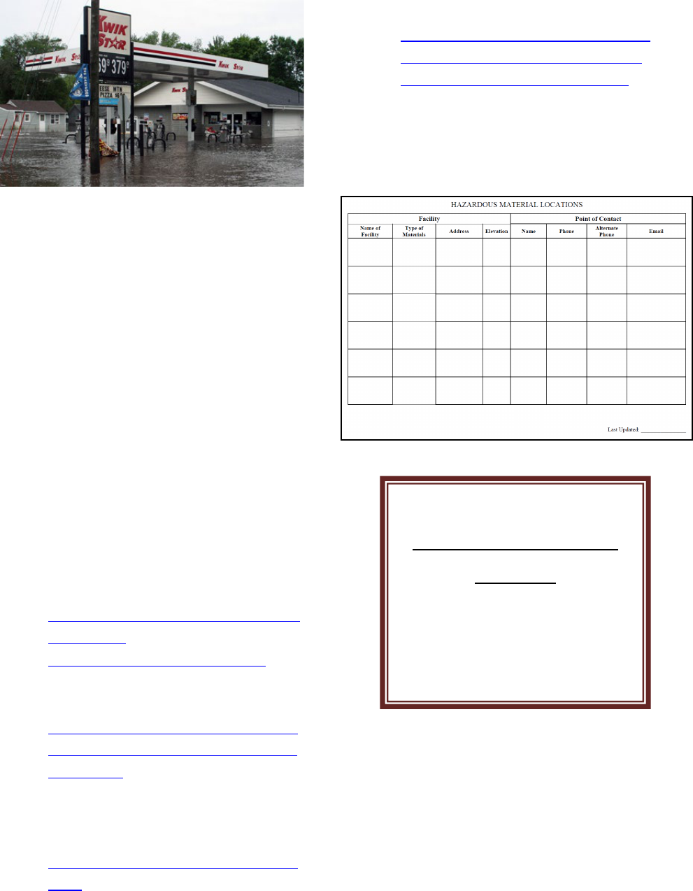
Identifying Possible Locations. As part of
your Emergency Action Plan, you will want
to identify businesses and facilities that have
potentially hazardous materials. A form is
included to facilitate capturing this
information. These could include fuel
storage and underground tanks, herbicides,
pesticides, water treatment chemicals, and
lubricants to name a few examples. In rural
areas, agriculture-related businesses might
have fertilizers and other chemicals. Often
agencies that keep such records include the
fire department, the county emergency
management department, or the state
pollution control offices.
Above-Ground Propane Tanks. Care
should be taken to secure above-ground
propane tanks to solid foundations prior to a
flood event to avoid floatation. Floating
propane tanks become a safety and
environmental hazard and can impair post-
flood recovery efforts.
Lessons Learned:
Reducing spills from service
stations or convenience stores:
Underground storage tanks are
the responsibility of the owner,
not community/tribe staff or
officials. Tanks not anchored
can float out of the ground when
subjected to high floodwaters or
even high groundwater. EPA
has created a guide and checklist
for steps to take before and after
a flood.
If you only have time
to do one thing for this
chapter on hazardous
materials: Have a list
of businesses, city or
tribal buildings, and
other facilities that
work with hazardous
materials and a good
afterhours point of
contact for each.
40
Photo: FEMA/Greg Henshall
Responsibility. Each individual business is
responsible for their materials and clean-up
if the materials are flooded. They should,
however, be encouraged to develop their
own flood emergency action plan which
could include moving materials to higher
elevations, reducing the amount of materials
stored, or topping off storage tanks to keep
them from floating. The community’s and
tribe’s responsibility lies only in notifying
owners of the potential flood threat.
List of Additional Resources:
• EPA Underground Storage Tank
Flood Guide:
https://www.epa.gov/sites/production
/files/2014-
03/documents/ustfloodguide.pdf
• Case Study:
http://scholarcommons.usf.edu/cgi/vi
ewcontent.cgi?article=1002&context
=fmhi_pub
• Hazardous Material Guide for First
Responders:
https://www.hsdl.org/?abstract&did=
1258
• Example of a plan for a company:
http://www.willis.com/documents/pu
blications/Services/Claims_Manage
ment/TAB_Flood_Loss_0811.pdf
Forms.
• List of businesses with hazardous
materials.
CHECKLIST
Chapter 12 – Hazardous
Materials
List of businesses
with after hour
points of contact

41
EMERGENCY ACTION
PLAN
CHAPTER 13
COMMUNICATIONS
Background. Communications are critical
to the success of a flood event response.
The National Incident Management System
(NIMS) specifies that communications
should be interoperable, reliable, scalable,
portable, resilient, and redundant.
Communications Plan. As part of the
overall flood emergency action plan, it is
recommended that all the tasks discussed in
this chapter be captured in a document
referred to as a Communications Plan. A
thorough communications plan can be as
extensive as this entire emergency action
plan and is something to strive for. In the
7
Markowitz, Deb. “What we learned from Vermont’s epic flood.” cnn.com. CNN Opinion, 16 September 2013.
Web. 19 March 2014.
meantime the items discussed in this chapter
will be a starting point.
Communications During a Flood. It is
important that information be provided
frequently and through as many means as
possible during a flood. Misinformation and
rumors should be dealt with directly. All
information being released should go
through one person in the Emergency
Operations Center, the designated
spokesperson, to assure conflicting
information is not being distributed.
7
If you only have time
to do one thing for this
chapter on
communications,
decide who will be the
designated
spokesperson and
commit to frequent
communications with
the public.
Lessons Learned
: “The
first casualty of a crisis is
information. Make sure you
have the facts before you
act. Talk to the folks in the
field. Share relevant
information with the
emergency response
directors. Let the public
know what you know
through updates and
guidance from your experts.
You cannot communicate
too much.” - Deb
Markowitz, Secretary of the
Vermont Agency of
Natural Resources on advice
to the state of Colorado.
7

42
Designated Spokesperson or Public
Information Officer. A person should be
designated that will handle press releases,
coordinate information being released, and
be the point of contact for reporters and
media requests. A small community or tribe
that is already short staffed should request
assistance if they have no one to serve this
role. This person would be in addition to the
Mayor or Chairperson who will be speaking
at press conferences and assuring the public
that they are being provided with the most
current and accurate information.
Methods of Communicating. Below are
several means of communicating with the
public.
• Press Releases. Press releases
should include links where people
can find additional information.
Sample press releases are attached.
• Radio and Television. Local radio
and television have been
instrumental in keeping the public
informed in the past, but need to be
provided with up-to-date
information.
• Reverse 911. This system allows for
pre-recorded messages to be sent to
all phones in a specified geographic
area. Unlisted numbers and cell
phones can be registered as part of
the system. Since many households,
particularly of the younger
generation, no longer maintain a hard
line telephone it is important to
encourage people to register ahead of
time.
• Social Media. Social media use has
increased exponentially in the past
few years. In response, the U.S.
Department of Homeland Security’s
Science and Technology Directorate
(DHS S&T) established the Virtual
Social Media Working Group
(VSMWG) in December 2010 and
has since published a guide and
lessons learned from Hurricane
Sandy on using social media. A link
to this report is provided.
Photo: FEMA/Christopher Mardorf
• Radio Amateur Civil Emergency
Services (RACE). This is a
volunteer organization of licensed
amateur radio operators organized
under FEMA and the FCC. Ham
radios have a long history of
providing support during disasters
and should be a part of every back-
up plan. As a minimum it may be
beneficial to make contact with the
ham radio users in your area.
Interoperability. In past large disasters like
Hurricane Katrina, one of the key lessons
learned has been that it is critical that first
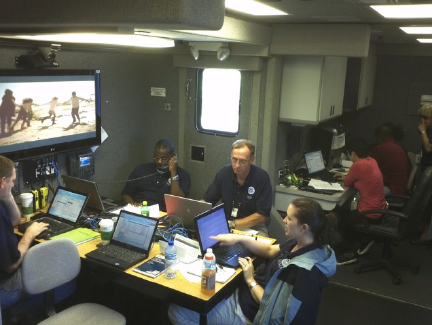
43
responders be able to talk to each other and
to the emergency operations center, even
with the loss of power. It is vital that the
emergency operations center be able to
communicate with people in the field. It
may be as straight forward as acquiring
spare radios that can be distributed during an
event. What’s important is that you
understand your current means of
communication and talk through what your
plan – and backup plan - will be. Links are
provided to lessons learned from other
communities.
Photo: FEMA/Bradley Carroll
Incident Management Software. States
use incident management software to track
reports from local emergency operations
centers to the state emergency operation
center. Incident management software has
the added advantage of tracking requests and
allowing a wide range of agencies to have
access to view requests and reports. From
the local perspective, it is important to know
who to contact to enter your requests into
the state system (this is typically your
county emergency manager).
Communication Tools at the Emergency
Operations Center. Three invaluable tools
at the EOC are a high quality speaker phone,
a conference call-in number, and the ability
to conduct a web-meeting.
• A high quality speaker phone with
satellite speakers is crucial when a
large number of the members at the
EOC want to be involved in a call
with state or federal officials or staff
in the field. Make sure the system is
compatible with the phone system in
the EOC.
• A call-in number, usually a toll-free
number with an access code, can
allow multiple callers to participate
in a virtual meeting.
• The third tool, the ability to conduct
web meetings, is the next level of
technology and allows a virtual
meeting to view the same documents
and maps on line and share sketches.
Often state and federal agencies will
have these resources, but the use is
limited by local availability.
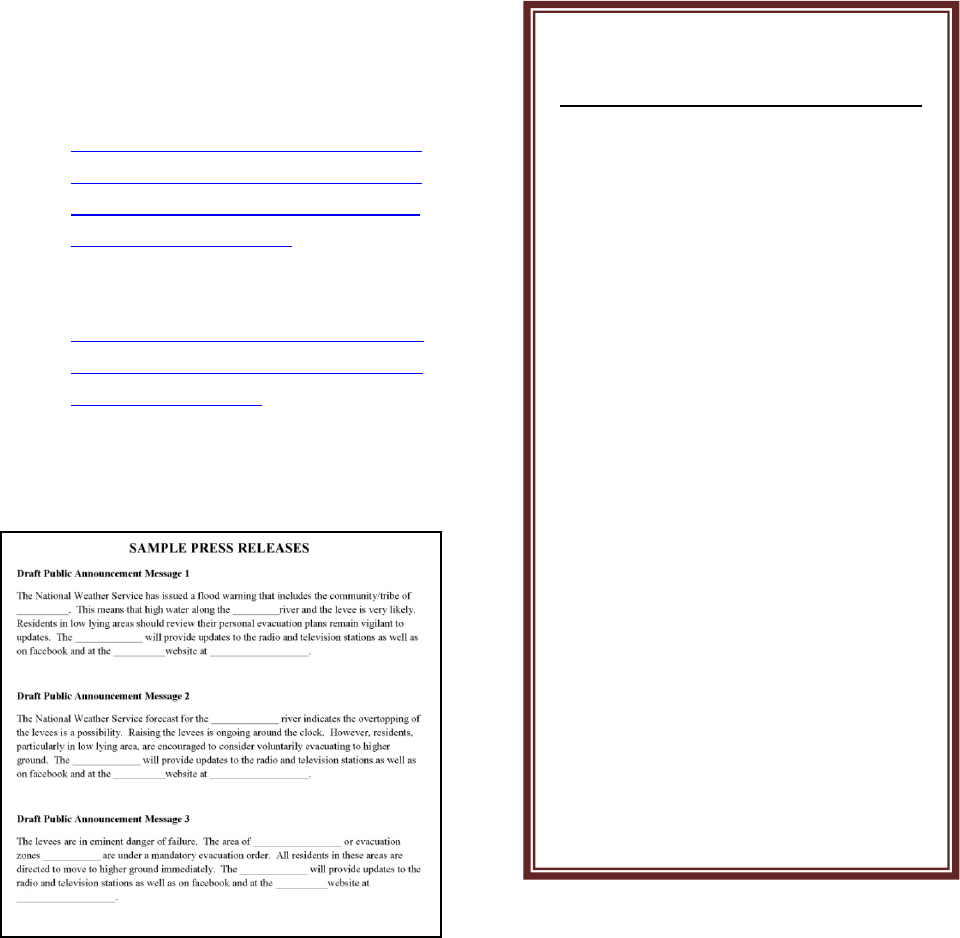
44
List of Additional Resources:
• Social Media and Hurricane Sandy:
Lessons Learned:
https://www.dhs.gov/sites/default/fil
es/publications/Lessons%20Learned
%20Social%20Media%20and%20H
urricane%20Sandy.pdf
• Sample communications plan:
https://www.nvcc.edu/emergency/_d
ocs/CrisisCommunicationProtocols_
11_03_14-Final.pdf
Forms.
• Sample press releases
CHECKLIST
Chapter 13 - Communications
Public review for
Emergency Action Plan
Designated
spokesperson
Sample press releases
Reverse 911 system in
place
Plan on how to use
social media
Ham operators
contacted
Confirm
interoperability between
radio systems
Acquire speaker phone
and call-in number for
conference calls.

45
EMERGENCY ACTION
PLAN
CHAPTER 14
TRAINING AND EXERCISES
Background. There are management
systems in place that are to be used at all
levels of government during a flood fight or
any emergency. What is important to know
is that the local government is responsible
for taking command. Local staff and elected
officials should be trained on the following
topics.
National Incident Management System
(NIMS). Since the September 11 terrorist
attacks and the 2004 and 2005 hurricane
seasons, it became clear that a
8
Lawrence, Cortez. “Fire Service Operations for the Southeastern Tornadoes – April 2011.” www.usfa.fema.gov.
FEMA, April 2012. Web. 31 October 2013.
comprehensive approach to emergency
responses was needed that would address all
disasters, at all levels of government, and
across all functional disciplines. The
National Incident Management System, or
NIMS, spells out how this approach is to
work. It is important that local communities
understand their role, speak the language,
and know how to ask for what they need
during a flood emergency.
8
Incident Command Systems (ICS). ICS
evolved from an approach developed in
California in the 1970’s by firefighters that
saw the importance in being able to manage
a response across multiple jurisdictional
boundaries. Management of the flood
response is always at the local level, with
expansion as needed. The key
Lessons Learned:
“We can
never do too much planning,
training, and evaluation, and
repeat that cycle again.
Individual, company, and
department competencies must
be ensured through training,
practice, exercises, honest
evaluation, and leadership.
Roles and responsibilities must
be known and practiced pre-
event.” -2011 Southeastern
Tornadoes Report. (Following
Joplin, MO tornado)
8
If you only have time
to do one thing for this
chapter on training:
Gather your team,
assume a flood
scenario, and talk
through the steps you
would take to fight a
flood. This is a
tabletop exercise.

46
characteristics of the incident command
system include:
• Common terminology
• Management by objectives
• Comprehensive resource
management
• Integrated Communications
• Unified Command
• Accountability
• Information and Intelligence
Management
Photo: FEMA/Marilee Caliendo
FEMA Training. FEMA offers free on-line
training courses tailored towards emergency
response and recovery personnel, including
the National Incident Management System
(NIMS) and Incident Command Systems
(ICS). Many state departments of
emergency management make training in a
classroom setting available at minimum or
no cost. This can be a good opportunity to
network with representatives from other
communities or tribes.
Photo: FEMA/Jocelyn Augustino
Tabletop Exercises. One of the best
exercises is a tabletop exercise. A facilitator
is recommended, a problem is presented,
and the participants talk through the process
and identify potential areas for
improvement. The exercise should always
include a way for recommended
improvements to be made to the current
plan.
List of Additional Resources:
• FEMA training is available at:
https://training.fema.gov/is/
• National Response Framework:
https://www.fema.gov/media-
library/assets/documents/117791
• FEMA Table Top Exercise:
http://www.fema.gov/emergency-
planning-exercises
• Guide to a Successful Table Top
Exercise:
http://www.preparis.com/blog/guide-
to-successful-tabletop-exercises/

47
• Training available through the
Emergency Management Assistance
Compact (EMAC):
http://www.emacweb.org/index.php/t
rainingeducation
Forms: None
CHECKLIST
Chapter 14 - Training
National Incident
Management
System Training
completed
Training through
FEMA or the State
EOC completed
Tabletop exercise
scheduled

48
EMERGENCY ACTION
PLAN
CHAPTER 15
MITIGATION, FLOODPLAIN
MANAGEMENT AND
INSURANCE: LESSONS
LEARNED
Summary. In this chapter lessons learned
will be presented on:
• Flood Fighting
• Recovery
• Flood insurance.
Flood Insurance. It is important that
residents are protected by separate flood
insurance as flooding is not covered by
typical homeowners insurance. This needs
to be done in advance of flooding since there
is usually a 30-day waiting period from date
of purchase before the policy goes into
effect.
Photo: U.S. Army Corps of Engineers
If you only have time to do
one thing for this chapter
on lessons learned: Make
sure your community or
tribe is eligible for flood
insurance (available
through the National Flood
Insurance Program (NFIP)
and residents are
encouraged to purchase.
Lessons Learned:
Some
communities such as Grand
Forks, ND after the 1997
flood and Greensburg, KS
after the 2007 tornado took
the opportunity to rebuild
and be better than before.
Rather than focusing on
reclaiming what they had
lost, they focused on how
they could use the
opportunities to build a
better future.
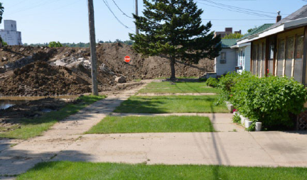
49
Photo: U.S. Army Corps of Engineers
National Flood Insurance Program. This
is a federal program created by Congress
and managed by FEMA. The purpose is to
mitigate future flood losses nationwide
through sound, community-enforced
building and zoning ordinances and to
provide access to affordable, federally
backed flood insurance protection for
property owners. Participation in the
program is based on an agreement between
local communities and the Federal
Government that states that if a community
or tribe will adopt and enforce a floodplain
management ordinance to reduce future
flood risks to new construction in Special
Flood Hazard Areas, the Federal
Government will make flood insurance
available as a financial protection against
flood losses. After a community or tribe
joins the program, a policy may be
purchased from any licensed property
insurance agent or broker. The agent will
complete the flood insurance application,
obtain the proper supporting documentation
required, and determine the rates for
establishing the flood insurance premium.
National Flood Insurance Program’s
Community Rating System. This system
recognizes a community’s or tribe’s efforts
that go beyond the minimum standards of
the National Flood Insurance Program
(NFIP) and reduces flood insurance
premiums for property owners. Discounts of
5-45 percent are possible. Some of the
creditable activities involve educating and
providing flood insurance data to the public,
managing new development, establishing
stricter floodplain requirements, acquiring
homes in the floodplain, and maintaining
existing levees.
Hazard Mitigation Grant Program.
Federal funding under this program is
available following a major disaster
declaration requested by the Governor. The
funding is allocated using a “sliding scale”
formula based on the percentage of funds
spent on Public and Individual Assistance
for each Presidential declared disaster.
These grant funds can be used to buy out
low lying residents or make other
improvements that will reduce the risk in the
next flood. However, this funding is
available only if the community, tribe,
county and state have a series of nested all-
hazard mitigation plans. State plans are
revised and approved by FEMA every 3
years; county plans are re-done every 5
years.
Mitigation Planning. There may be
opportunities to mitigate future damages
from flooding. This could include managing
floodplain development at the local level,
obtaining grants to remove homes from the
floodplain, or taking steps to qualify the
community or tribe for reduced flood
insurance rates. Your state or FEMA flood
insurance points of contact are a good
resource for these opportunities.
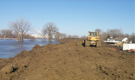
50
Risk Management Planning. FEMA also
encourages communities and tribes to
consider what could reasonably happen
during a flood fight that could complicate
and hamper emergency activities. Some
issues to consider include:
• Potential security issues such as
terrorism, vandalism, looting, or
other violent activities.
• Potential power outages.
• Coincident flood events such as
small tributaries cresting as the same
time as the main flooding source.
• Impacts of unexpected failures such
as pumps, gates or other critical
features.
• Higher than expected releases from
an upstream dam that could impact
flood volumes.
• Other unexpected perils such as
hazardous debris or displaced farm
animals or wildlife.
Photo: U.S. Army Corps of Engineers
Lessons Learned on Flood Fighting. The
most important lessons learned are the ones
you capture for your own community!
Specifically those lessons learned from
previous flood flights or other emergency
experiences. Although not all may be
applicable to your situation, below are
several lessons learned by a small
community.
• Have a good hydraulic profile
through your community.
• Have specific tasks identified to be
completed at various flood stages.
• If you have a volunteer fire
department, make arrangements for
their labor to be paid.
• If the volunteer fire department is
fully engaged in the flood fight,
make arrangements for other fire
departments to respond to fires.
• High School students make good
sand baggers and you may want to
request school be let out to assist.
• If there are too many sightseers,
consider issuing no-travel alerts.
• A good source of clay for levees
needs to be identified ahead of time.
• The National Guard can be a good
source of support for traffic control
and manning pumps.

51
• Good communications are needed
between the City Emergency
Management and the County and
State.
• All storm water pipes discharging
into the river need to have flap gates
or other means of closure to prevent
water from backing up into the
community.
• Leaks and infiltration into the
sanitary sewer system can
overwhelm the lift stations and
compromise the entire system.
• Ice jams under bridges can raise
water levels significantly and it
might be beneficial to pro-actively
push the ice under to the bridge to
keep it from jamming. Ice jams can
also occur in river bends and at
dams. It is important to document
the history of ice jams in your area.
• The Emergency Manager should not
be the Public Works Director as they
are best dedicated to focusing on the
utilities.
Photo: FEMA/Marilee Caliendo
Lessons Learned on Recovering from a
Flood. You and community staff will be
exhausted from the flood fight and may have
even suffered personal losses and damages.
Then the recovery will begin with political
issues and a vast amount of paperwork and
documentation. Learning about all the
processes and available options can be
overwhelming. Often there will be difficult
political decisions to be made regarding
rebuilding. The best thing you can do is get
as much help as possible, through mutual aid
agreements with other local communities
and tribes, from county, state, federal and
volunteer agencies, and consultants.
Photo: U.S. Army Corps of Engineers
Below are some lessons learned from other
communities:
• Establish points of contacts in state
and federal agencies and a liaison to
work with each.
• Document everything – too much
information is never enough.
• Challenge/Encourage legislators
(Federal and State) to figure out

52
ways to streamline regulations such
as bidding procedures and resources
procurement.
• Utilize public forums and design
charrettes for recovery changes.
• Leverage Federal resources with
local ones for long-term investment.
• Condemning damaged homes can be
a challenging process requiring a lot
of communication and additional
staffing.
• Getting power, water, and heat
restored is critical to recovery.
• Require licensing of contractors and
transient merchants, including
bonding, criminal background
checks, and photo I.D’s. This will
help safeguard people from “fly by
night’ operations.
• Pro-active steps need to be taken to
make sure there is housing and day
care for residents and housing for the
influx of workers.
• Coordinate local, county and state
hazard mitigation plans to ensure
eligibility for Hazardous Mitigation
Grant Program grants.
List of Additional Resources:
• Since the 1997 flood and their
successful recovery, the City of
Grand Forks, ND has made many of
their materials and processes
available for other communities:
https://www.grandforksgov.com/our-
city/history/flood-recovery
• Information on FEMA’s National
Flood Insurance Program:
http://www.fema.gov/national-flood-
insurance-program
• Information on FEMA’s Hazard
Mitigation Grant Program:
http://www.fema.gov/flood-
mitigation-assistance-program
• Minnesota Department of
Commerce:
https://mn.gov/commerce/consumers
/your-home/protect/other/floods/
• Answers to questions about the
National Flood Insurance Program:
http://www.fema.gov/media-
library/assets/documents/272?id=140
4
• Iowa Lessons Learned:
http://publications.iowa.gov/11080/1
/2011-
06_Iowa_Disaster_Recovery_Lesson
s_Learned_final.pdf
• Proactive Flood and Drought
Management:
http://aquadoc.typepad.com/files/awr
a_report_proactive_flood_drought_fi
nal.pdf
• Lessons We Don’t Learn:
http://faculty.nps.edu/dl/HFN/docum
ents/DisasterLessons.pdf
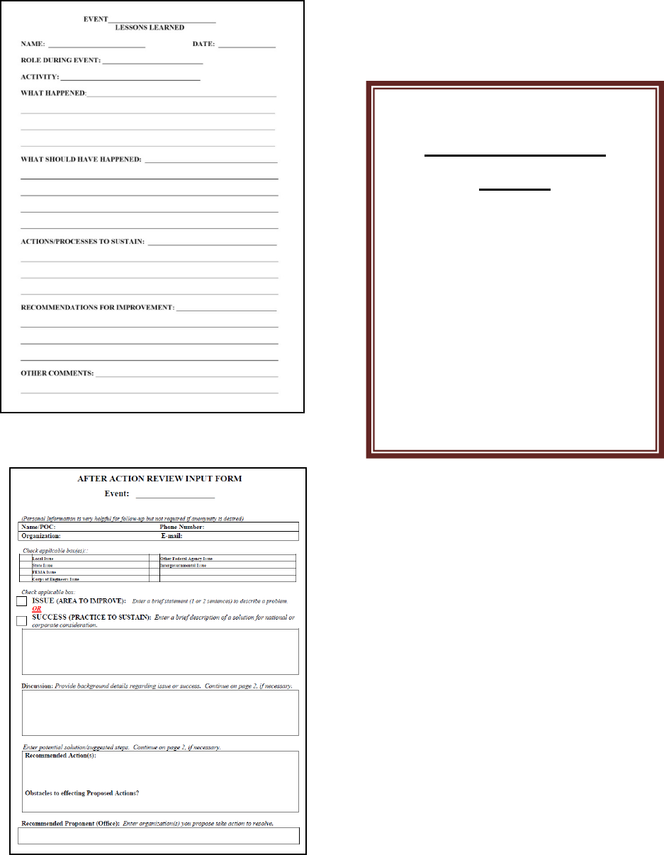
53
Forms:
• Lessons Learned
• After Action
CHECKLIST
Chapter 15 – Lessons
Learned
Educate community
and tribe regarding
flood insurance
Grant application for
mitigation funding.
Capture lessons
learned from past flood
fights.
54
APPENDIX A
LINKS TO RESOURCES

55
Note: Sometimes links that don’t readily open when clicked will open when copy and
pasted into your internet browser. For digital copies of the resources listed below, see the
CD accompanying this guide.
Chapter 1 - Introduction
• Midwest Assistance Program Preparation Guide for Small Communities (select “Flood
Emergency Action Procedures” in lower right corner of page):
http://www.map-inc.org/
• FEMA’s “Developing and Maintaining Emergency Operations Plans”:
https://www.fema.gov/media-library/assets/documents/25975?id=5697
• California “Sample Flood Safety Plan”:
http://www.water.ca.gov/floodsafe/docs/SampleFloodSafetyPlan-DraftMarch_2011.pdf
• Flood Emergency Response Plan Before Disaster Strikes:
http://www.lockton.com/whitepapers/Creating_a_Response_Plan_Before_Disaster_Strikes.pdf
• Flood Emergency Action Plans by FERC, Chapter 6:
https://www.ferc.gov/industries/hydropower/safety/guidelines/eng-guide/chap6.pdf
Chapter 2 - Authority
• None
Chapter 3 – Mutual Aid Agreements
• NIMS Core Document: https://www.fema.gov/pdf/emergency/nims/NIMS_core.pdf
• Mutual Aid Lessons Learned from California: https://www.hsdl.org/?view&did=484122
• EPA Mutual Aid Information:
http://water.epa.gov/infrastructure/watersecurity/mutualaid/index.cfm
• ASTHO Emergency Authority and Immunity Toolkit:
http://www.astho.org/Programs/Preparedness/Public-Health-Emergency-
Law/Emergency-Authority-and-Immunity-Toolkit/Mutual-Aid-and-Assistance-
Agreements-Fact-Sheet/

56
• King County Sample Mutual Aid Agreement:
http://www.kingcounty.gov/~/media/safety/prepare/documents/EMProfessionals_Plans/D
ebrisMgmtplan/APPENDIX_B.ashx?la=en
• Link to EMAC, Emergency Management Assistance Compact:
http://www.emacweb.org/
• American Water Works Mutual Aid Agreements: https://www.awwa.org/Resources-
Tools/Resource-Topics/Water-Wastewater-Agency-Response-Network/WARN-
Resources
Chapter 4 - Personnel
• Case Study of Incident Command Systems:
http://cra20.humansci.msstate.edu/From%20Forest%20Fires%20to%20Katrina.pdf
• FEMA’s “Protect Your Property from Flooding”: http://www.fema.gov/media-
library/assets/documents/13261?id=3262
Chapter 5 – Outside Contacts
• Corps of Engineers:
http://www.mvp.usace.army.mil/Missions/EmergencyManagement.aspx
• USGS: http://waterdata.usgs.gov/usa/nwis/rt
• NWS: http://water.weather.gov/ahps/forecasts.php
• General: http://www.ready.gov/
• FEMA: http://www.fema.gov/
Chapter 6 – Flood Elevations, Mapping, and History
• NWS Advanced Hydrologic Prediction Service:
http://water.weather.gov/ahps/forecasts.php
• NWS River Gages: http://water.weather.gov/ahps/forecasts.php

57
• NWS Hydrologic Local Contacts: https://www.weather.gov/water/hydrologic_contacts
• Converting NGVD 1929 elevations to NAVD 1988: http://www.ngs.noaa.gov/cgi-
bin/VERTCON/vert_con.prl
• FEMA Map Service Center:
https://msc.fema.gov/portal
• FEMA Digital Flood Insurance Maps:
http://fema.maps.arcgis.com/home/webmap/viewer.html?webmap=cbe088e7c8704464aa
0fc34eb99e7f30
• The link to Minnesota topography can be found at:
http://www.dnr.state.mn.us/maps/mntopo/index.html
• Orange County CA Flood fighting advice: http://ocflood.com/safety/fight/
Chapter 7 – Tasks and Prioritized Actions
• Corps of Engineers St. Paul District Flood Manual:
www.mvp.usace.army.mil/Portals/57/docs/Operations%20Center/MVP_Flood_Fight_Ha
ndbook_2016.pdf
Chapter 8 – Emergency Shelters
• Shelter Guidance and Shelter Staff Matrix: http://nationalmasscarestrategy.org/sheltering/
•
Red Cross Shelters – Alameda County, CA:
https://www.cdc.gov/nceh/ehs/Docs/Guide_for_Local_Jurisdictions_Care_and_Shelter_P
lanning.pdf
• Pet Evacuation Guidelines from FEMA: Household Pet and Service Animal Planning
Checklist: www.tahc.state.tx.us/emergency/FEMA_CPG302_HouseholdPets.pdf
• Animal Shelter Operations: Pet Friendly Shelters:
https://www.ready.gov/sites/default/files/documents/files/FEMAPetShelteringbestpractic
es2007.pdf

58
• Livestock Evacuation Guidelines from the University of Vermont:
http://www.uvm.edu/~ascibios/?Page=Emergency/Disaster_Planning_for_Livestock.html
&SM=submenuemergency.html
• ASCE Article on lessons learned: “Assessment of Public Shelter User’ Satisfaction:
Lessons learned from South-Central Texas Flood:
https://ascelibrary.org/doi/pdf/10.1061/%28ASCE%29NH.1527-6996.0000055
Chapter 9 – Evacuation
• Vulnerable Residents Registration:
https://webapps4.broward.org/VulnerableRegistry/Welcome.aspx
• City of Chicago Registration:
https://webapps1.cityofchicago.org/volunteerregistry/checkDisclaimer.do
• Health Affairs Evacuation – the challenge of mandatory evacuations:
https://www.healthaffairs.org/doi/pdf/10.1377/hlthaff.25.4.958
• California information on evacuations:
https://www.caloes.ca.gov/PlanningPreparednessSite/Documents/02%20FEAT%20Legal
GuidelinesforFloodEvacuation(FEAT%20doc).pdf
• National Weather Service Campaign “Turn Around, Don’t Drown”:
https://www.weather.gov/safety/flood-turn-around-dont-drown
Chapter 10 - Utilities
• None
Chapter 11 – Critical Facilities
• Emergency Power Facility Assessment Tool: https://epfat.usace.army.mil/
• State of Florida Standard Operating Procedures for Critical Facilities:
http://www.training.fema.gov/EMIWeb/edu/docs/HistoricalInterest/Florida%20Division
%20of%20EM%20-%20CFI-RSFI,%20Standard%20Operating%20Guidel.doc

59
Chapter 12 – Hazardous Materials
• EPA Underground Storage Tank Flood Guide:
https://www.epa.gov/sites/production/files/2014-03/documents/ustfloodguide.pdf
• University of South Florida Case Study:
http://scholarcommons.usf.edu/cgi/viewcontent.cgi?article=1002&context=fmhi_pub
• Hazardous Material Guide for First Responders:
https://www.hsdl.org/?abstract&did=1258
• Example of a plan for a company:
http://www.willis.com/documents/publications/Services/Claims_Management/TAB_Floo
d_Loss_0811.pdf
Chapter 13 - Communications
• North Dakota WebEOC: https://www.nd.gov/des/planning/webeoc-training/Default.asp
• Social Media and Hurricane Sandy: Lessons Learned:
https://www.dhs.gov/sites/default/files/publications/Lessons%20Learned%20Social%20
Media%20and%20Hurricane%20Sandy.pdf
• Sample communications plan:
https://www.nvcc.edu/emergency/_docs/CrisisCommunicationProtocols_11_03_14-
Final.pdf
Chapter 14 – Training and Exercises
• FEMA training is available at: https://training.fema.gov/is/
• National Response Framework: https://www.fema.gov/media-
library/assets/documents/117791
• FEMA Table Top Exercise: http://www.fema.gov/emergency-planning-exercises
• Guide to a Successful Table Top Exercise: http://www.preparis.com/blog/guide-to-
successful-tabletop-exercises/

60
• Training available through the Emergency Management Assistance Compact (EMAC):
http://www.emacweb.org/index.php/trainingeducation
Chapter 15 – Mitigation, Floodplain Management and Insurance: Lessons Learned
• Since the 1997 flood and their successful recovery, the City of Grand Forks, ND has
made many of their materials and processes available for other communities:
https://www.grandforksgov.com/our-city/history/flood-recovery
• Information on FEMA’s National Flood Insurance Program:
http://www.fema.gov/national-flood-insurance-program
• Information on FEMA’s Hazard Mitigation Grant Program: http://www.fema.gov/flood-
mitigation-assistance-program
• Minnesota Department of Commerce: https://mn.gov/commerce/consumers/your-
home/protect/other/floods/
• Answers to questions about the National Flood Insurance Program:
http://www.fema.gov/media-library/assets/documents/272?id=1404
• Iowa Lessons Learned: http://publications.iowa.gov/11080/1/2011-
06_Iowa_Disaster_Recovery_Lessons_Learned_final.pdf
• Proactive Flood and Drought Management:
http://aquadoc.typepad.com/files/awra_report_proactive_flood_drought_final.pdf
• Lessons We Don’t Learn: http://faculty.nps.edu/dl/HFN/documents/DisasterLessons.pdf
61
APPENDIX B
FORMS AND SAMPLES
62
RECORD OF PLAN DISTRIBUTION
Date of Last Distributed Update: __________________
Distributed to:
1. Agency, Name, Address or Email (if done electronically)
2. _______________________________________________________________________
3. ________________________________________________________________________
4. ________________________________________________________________________
5. ________________________________________________________________________
6. ________________________________________________________________________
7. ________________________________________________________________________
8. ________________________________________________________________________
9. ________________________________________________________________________
10. ________________________________________________________________________
11. ________________________________________________________________________
12. ________________________________________________________________________

63
RECORD OF PLAN UPDATES
This flood emergency action plan will be reviewed for changes after the spring flood season of
each year, contact information will be updated, and the revisions approved by City Council each
January.
Version #
Description of Change
Date
Issued By:

64
PUBLIC MEETING SIGN-IN SHEET
Subject: ____________________________________________ Date: ______________
Location: ___________________________________________
Name Representing
Phone # (optional)
1
2
3
4
5
6
7
8
9
10
11
12
13
14
15
16
17
18
19
20
21
22
23
24
25
26
27
28
29
30
31
32
33
Please Sign In:
(print clearly)

65
Name: ____________________________ Telephone: _________________
Address: ______________________________________________________
City: ________________________ State: _____________ Zip: _________
* Name, Telephone, and Address are optional and may be left blank
I would like email notifications at: _______________________________
(Please provide your comments in the space below)
_____________________________________________________________
_____________________________________________________________
_____________________________________________________________
_____________________________________________________________
_____________________________________________________________
_____________________________________________________________
_____________________________________________________________
_____________________________________________________________
_____________________________________________________________
_____________________________________________________________
Privacy Act Statement:
In accordance with the Privacy Act of 1974 (Authority: Chapter 5, ER 1105-2-100), routine uses of the
information obtained from this form include compiling official mailing lists for future informational
publications and recording additional views and public participation in studies.
Meeting Agenda
Date: ___________
________________________________
________________________________
________________________________
________________________________
________________________________
________________________________
Keep posted on the plan progress at:
http://www. .com
Mail any additional comments to us at:
_______________________________
_______________________________
_______________________________
PUBLIC MEETING COMMENT SHEET
LOGO
Date: __________
66
SAMPLE RESOLUTION FOR AUTHORITY TO BEGIN
EMERGENCY ACTION PLAN
(Name of Board or Council)
(Name of government unit, e.g., City of ________, ________Tribe)
------------------------------------------
Resolution #_____
WHEREAS, the ________________ wishes to prepare a Flood Emergency Action Plan to better
prepare for the next flood fight; and
WHEREAS, the plan will require the efforts of a committee and public review;
NOW, THEREFORE, BE IT RESOLVED THAT ____________________ grants authorization
for the Committee to prepare a draft plan for the review by the public and this Council;
BE IT FURTHER RESOLVED that the Committee will be chaired by _________________ and
the members of the Committee will be selected by the Chairperson.
APPROVED AND ADOPTED by the (Council or Board) on this date __________________.
AYES: ___________________________________________________
NAYES: __________________________________________________
ABSENT: __________________________________________________
_____________________________________
(Chairperson or Mayor)
ATTEST:
_______________________________________________________
Clerk/Secretary ____________________________________________

67
SAMPLE EMERGENCY DECLARATION
WHEREAS, the City of _____________ has a very high soil moisture content due to
precipitation received during _______, along with significant snowpack.
WHEREAS, the potential for sever spring flooding is high due to the combination of spring
snowmelt and expected precipitation.
WHEREAS, the impacts of severe flooding threaten the health, public safety, and well-being of
residents of _____________.
WHEREAS, the potential damage to public and private property is greater than normal and
exceeds the funds budgeted by the City.
NOW THEREFORE, BE IT RESOLVED that the City Council of _____________ declares an
emergency and orders the utilization of the _____________ Emergency Action Plan to limit the impacts
of the impending flood upon the citizens of _____________.
DATED at _____________ this _____ day of _____________, ______.
ATTEST:
________________________________
(Name)
(Position)
(Name)
(Position)
City of _____________

68
Date:______________
CALL TREE
FOR
____________________________
Name: ______________
Number: ____________
Number: ____________
Name: ______________
Number: ____________
Number: ____________
Name: ______________
Number: ____________
Number: ____________
Name: ______________
Number: ____________
Number: ____________
Name: ______________
Number: ____________
Number: ____________
Name: ______________
Number: ____________
Number: ____________
Name: ______________
Number: ____________
Number: ____________
Name: ______________
Number: ____________
Number: ____________
Name: ______________
Number: ____________
Number: ____________
Name: ______________
Number: ____________
Number: ____________
Name: ______________
Number: ____________
Number: ____________
Name: ______________
Number: ____________
Number: ____________
Name: ______________
Number: ____________
Number: ____________

69
Page 1 of __
PERSONNEL FOR FLOOD ORGANIZATION
The following personnel have been identified as part of the flood organization.
NAME &
POSITION
CELL PHONE HOME PHONE WORK PHONE EMAIL ADDRESS OTHER

70
Page __ of __
PERSONNEL FOR FLOOD ORGANIZATION (CONTINUED)
NAME &
POSITION
CELL PHONE HOME PHONE WORK PHONE EMAIL ADDRESS OTHER
71
ORGANIZATIONAL
CHART

72
OUTSIDE CONTACTS
Name
Phone
Alternate Phone
Email or Website
Key Websites
National Weather Service
USGS
Other
Utilities
Water
Sewer
Gas
Electric
Telephone
Cable/Communications
Other
Last Updated: 1/3/18

73
OUTSIDE CONTACTS (CONTINUED)
Name
Phone
Alternate Phone
Email or Website
Mutual Aid Contacts
County
County Emergency
Management
County Sheriff
Other
Last Updated: 1/3/18

74
OUTSIDE CONTACTS (CONTINUED)
Name
Phone
Alternate Phone
Email or Website
State
State Emergency
Management/Homeland
Security
State Duty Officer
Dept. of Natural
Resources
Dept. of Transportation
National Guard
Other
Federal
Corps of Engineers
FEMA
NRCS
HUD
Other
Last Updated: 1/3/18

75
OUTSIDE CONTACTS (CONTINUED)
Name
Phone
Alternate Phone
Email or Website
Other
Red Cross
Salvation Army
Volunteer Organizations
Ham Radio Operators
Local Churches
Other
Last Updated: 1/3/18

76
Page 1 of __
TASK SUMMARY LIST BY ELEVATION
This table is a summary of what actions need to be taken, the order they should be taken, and an estimated river stage at which the activity
should happen. It also serves as the table of contents for the next set of worksheets. After each flood this list should be revisited to see if
changes are recommended.
Task Worksheet
No.
River Stage Task Notes

77
Page __ of __
TASK LIST
CONTINUED
Task Worksheet
No.
River Stage Task Notes

78
Page 1 of __
TASK WORKSHEET
TASK NO. _____
TASK TITLE: _________________________
River Stage
Task Description
Cautions:
Detailed Task Description:
Equipment and Personnel Needed:
Photos:

79
Page __of __
TASK WORKSHEET
TASK NO. _____
TASK TITLE: _________________________
River Stage
Task Description
Cautions:
Detailed Task Description:
Equipment and Personnel Needed:
Photos:

80
Last Updated: ___________
SUMMARY OF SHELTERS
The following locations are identified for shelters: short term, long term, and for pets.
Location Elevation Point of Contact
Phone
numbers
Email
Short Term
Long Term
Allows Pets

81
Site Name:_________
Date:_________
EVALUATION OF SHELTERS
It is intended that this form be completed to the maximum extent possible for each shelter
evaluated. Then all evaluations should be reviewed by the committee, shelters selected, and
arrangements made to utilize the location if ever needed.
Name of Location:
Address of Location:
Date Evaluated:
Team Evaluating:
Point of Contact for Site:
(Name, Position, Phone)
EVALUATION FACTORS
Short-Term, Long-Term, or for Pets?
Estimated People That Could Be
Accommodated? (20-40 sft per person)
Is Facility Behind Levee?
Elevation of Facility:
Handicap Accessible?
Number of Toilets? (minimum 1 toilet per
40 people)
Number of Showers?
Kitchen Available?
Is Back-up Generator Available?
Would Location be Susceptible to Water or
Sewer Back-up?
Comments and Recommendations:

82
Last Updated: _________
SPECIAL NEEDS REGISTRY
Name: Address: Phone Number:
Alternate Contact
(Name and Phone):
Special Needs (Mobility,
Language barriers, Hearing or
Sight Limitations, Oxygen use,
etc.
83
SPECIAL NEEDS REGISTRY DURING TIMES OF EVACUATION
PARTICIPANT WAIVER SHEET
By signing below, I request that my name be added to the _____________________ Special
Needs Registry.
I understand that although efforts will be made to assist me should an evacuation be necessary,
this does not guarantee that resources will be available or that I will be given priority in
evacuating. I understand I should make my own arrangements and have a plan in place should
an evacuation be ordered due to flooding or other disasters.
I am providing this information voluntarily and will contact the ___________ Department at
__________ should my information change.
The ________________________ has my permission to contact my designated alternate if they
are unable to reach me in a timely manner.
SIGNED: ___________________________________
Name (Printed): ___________________________________
Date: ___________________________________
Designated Alternate:
Name: ___________________________________
Phone Numbers: ___________________________________
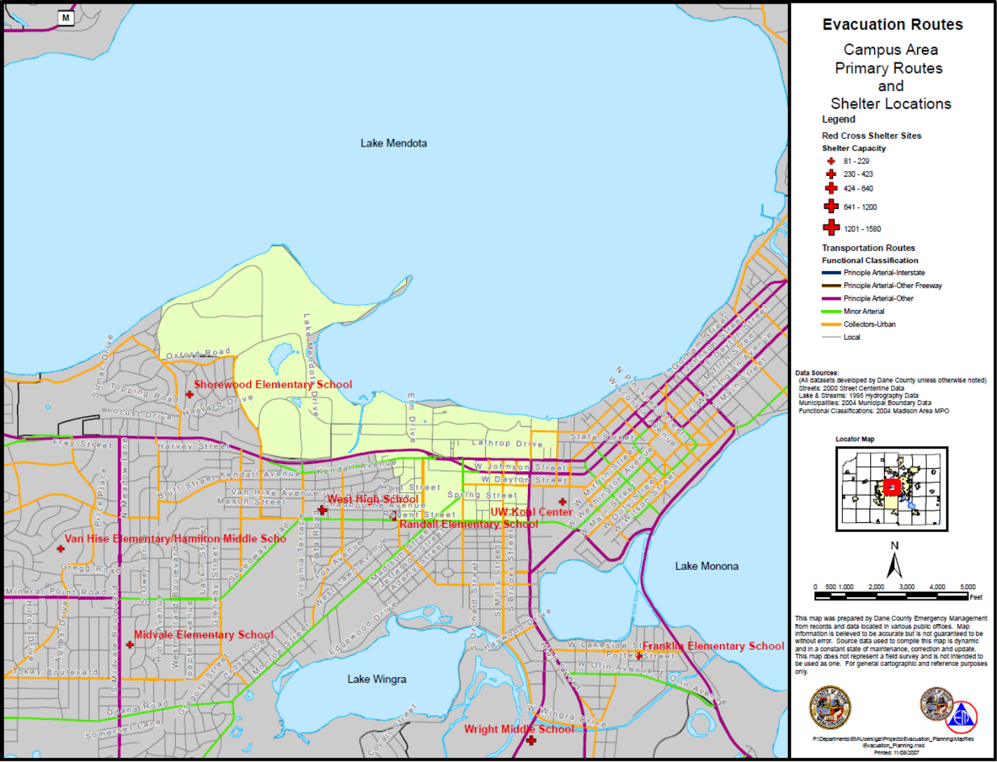
84
SAMPLE EVACUATION MAP

85
CRITICAL FACILITIES
Facility Point of Contact
Name of Facility Address Elevation Name Phone
Alternate
Phone
Email
Last Updated: ________________

86
HAZARDOUS MATERIAL LOCATIONS
Facility Point of Contact
Name of
Facility
Type of
Materials
Address Elevation Name Phone
Alternate
Phone
Email
Last Updated: ________________
87
SAMPLE PRESS RELEASES
Draft Public Announcement Message 1
The National Weather Service has issued a flood warning that includes the community/tribe of
__________. This means that high water along the _________river and the levee is very likely.
Residents in low lying areas should review their personal evacuation plans and remain vigilant to
updates. The _____________ will provide updates to the radio and television stations as well as
on facebook and at the __________website at ___________________.
Draft Public Announcement Message 2
The National Weather Service forecast for the _____________ river indicates the overtopping of
the levees is a possibility. Raising the levees is ongoing around the clock. However, residents,
particularly in low lying area, are encouraged to consider voluntarily evacuating to higher
ground. The _____________ will provide updates to the radio and television stations as well as
on facebook and at the __________website at ___________________.
Draft Public Announcement Message 3
The levees are in eminent danger of failure. The area of _________________ or evacuation
zones ___________ are under a mandatory evacuation order. All residents in these areas are
directed to move to higher ground immediately. The _____________ will provide updates to the
radio and television stations as well as on facebook and at the __________website at
___________________.
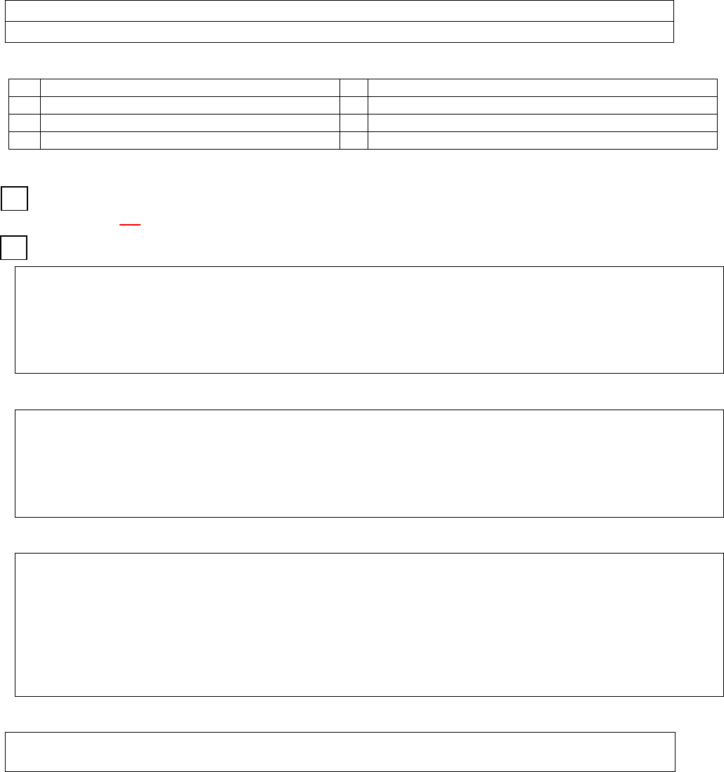
88
AFTER ACTION REVIEW INPUT FORM
Event: __________________
(Personal Information is very helpful for follow-up but not required if anonymity is desired)
Name/POC: Phone Number:
Organization: E-mail:
Check applicable box(es)::
Local Issue
Other Federal Agency Issue
State Issue
Intergovernmental Issue
FEMA Issue
Corps of Engineers Issue
Check applicable box:
ISSUE (AREA TO IMPROVE): Enter a brief statement (1 or 2 sentences) to describe a
problem. OR
SUCCESS (PRACTICE TO SUSTAIN): Enter a brief description of a solution for national or
corporate consideration.
Discussion: Provide background details regarding issue or success. Continue on page 2, if necessary.
Enter potential solution/suggested steps. Continue on page 2, if necessary.
Recommended Action(s):
Obstacles to effecting Proposed Actions?
Recommended Proponent (Office): Enter organization(s) you propose take action to resolve.
89
LESSONS LEARNED
EVENT______________________________
NAME: ___________________________ DATE: ________________
ROLE DURING EVENT: ________________________________
ACTIVITY: ____________________________________________
WHAT HAPPENED:___________________________________________________________
______________________________________________________________________________
______________________________________________________________________________
______________________________________________________________________________
WHAT SHOULD HAVE HAPPENED: ___________________________________________
______________________________________________________________________________
______________________________________________________________________________
______________________________________________________________________________
______________________________________________________________________________
ACTIONS/PROCESSES TO SUSTAIN: __________________________________________
______________________________________________________________________________
______________________________________________________________________________
______________________________________________________________________________
RECOMMENDATIONS FOR IMPROVEMENT: __________________________________
______________________________________________________________________________
______________________________________________________________________________
______________________________________________________________________________
OTHER COMMENTS: _________________________________________________________
______________________________________________________________________________

90
APPENDIX C
EXAMPLE FLOOD EMERGENCY PLAN

91
EMERGENCY ACTION PLAN
FOR THE COMMUNITY OF ANYWHERE, MN

92
RECORD OF PLAN DISTRIBUTION
Date of Last Distributed Update: 1/3/2018
Distributed to:
1. Agency, Name, Address or Email (if done electronically)
2. City of Nowhere, Steve Gosterman, 1221 Nothing Dr, Nowhere, MN 55555
3. US Army Corps of Engineers, Brett Nergtluh, [email protected]
4. Mayor, City of Anywhere
5. Council Members, City of Anywhere
6. City of Anywhere Emergency Action Plan Volunteer Committee
7. ___________________________________________
8. ___________________________________________
9. ___________________________________________
10. ___________________________________________
11. ___________________________________________
12. ___________________________________________

93
RECORD OF PLAN UPDATES
This flood emergency action plan will be reviewed for changes after the spring flood season of
each year, contact information will be updated, and the revisions approved by the Nowhere, MN
City Council each January.
Version #
Description of Change
Date
Issued By:
Draft 1
Initial distributed for comment before
finalizing
06/12/14 J. Doe
Version 1.0
Updated contact information, revisions
approved by City Council
01/03/18 J.Doe

94
TABLE OF CONTENTS
1. Purpose
a. Overall Project Map
2. Authority
3. Mutual Aid Agreements
4. Personnel for Flood Organization
a. Organizational Chart
5. Outside Contacts
6. Flood Elevations and History
a. Floodplain Map
b. Inundation Map
c. Map of Levee System
d. Hydraulic Profile
7. Tasks and Prioritized Actions
a. Task List
b. Task Worksheets
8. Emergency Shelters
a. Summary of Shelters
b. Evaluation of Shelters
9. Evacuation
a. Map of Evacuation Zones and Routes
10. Utilities
11. Critical Facilities
12. Hazardous Materials
13. Communications
14. Training
15. Lessons Learned
APPENDICES
A. Sample Resolution
B. Mutual Aid Agreements
C. Sample Press Releases

95
CHAPTER 1
PURPOSE
1. Statement of Purpose
The purpose of this plan is to describe the procedures to be used in the event of a flood.
This includes a description of the flood personnel organization, available resources such
as mutual aid agreements, and specific tasks to be accomplished to combat rising river
levels. This is intended to be a living document, revisited annually to ensure it remains
current.
2. Background
After the flood of 2013, a committee was formed to document procedures, lessons
learned, and information vital to the next event. The committee followed the National
Incident Management System, recognizing that a flood response is the responsibility of
the local community with County, State, and Federal resources to be requested as
needed. Once a draft document was prepared, a public meeting was held to provide
input. The document was then revised and approved by City Council.
3. History of Past Floods
a. Past floods. The City of Anywhere has experienced numerous flood events over
the past decades, with the most recent in 2013. The last flood fight was successful
but took an incredible amount of resources. The flood of record occurred in 1965
and was due to unprecedented snowfall in the winter of 1964-1965, sudden snow
melt in March 1965, and heavy rain. Spring snow melt floods tend to be most of
the annual peak flow events, but summer flash floods of shorter duration occur
from heavy rainfall, with interior drainage from storm water adding additional
risk.
b. Areas of concern. Some of the specific areas of concern include the downtown
area and the wastewater treatment plant. The Main Street bridge has had ice
jams in the past.
c. Lessons Learned. This document is intended to capture some of the lessons
learned from 2013 and past events so decisions can be made sooner and
resources obtained earlier.

96
4. Gage Information and Elevation Data
Location of gage. The gage is located on the north bank of the river near the downtown
bridge and is activated by the USGS during spring flooding. There is a back-up wire
weight gage on the bridge as well. This is only accessible from the north side when the
river reaches a stage of 14, as the south approach goes under water. A flood stage of 14
is equal to an elevation of 630. The City levees range in elevation from 620 to 640.
5. General Map
The aerial map below shows the existing levees, pump stations, road closures, and
critical infrastructure such as the wastewater treatment plant, City well house, sewer lift
stations, and storm water gated culverts that discharge into the river.
6. Future Steps
As part of the effort of creating this document, additional areas were recommended for
future development. These include:
a. Additional mutual aid agreements
b. Detailed inundation maps
c. Additional training for City staff and council members

97
GENERAL MAP

98
CHAPTER 2
AUTHORITY
1. Authority for Declaring an Emergency
The City Council has the authority to declare an emergency. City staff will prepare the
appropriate resolution and notify officials if an event likely to incur costs of more than
$100,000 is anticipated. There are positive reasons for declaring an emergency early
and few, if any, detrimental reasons for declaring an emergency that does not end up
materializing. However, if necessary, it is recommended that a special council meeting
be called if the timing is not favorable for waiting for the next regularly scheduled
meeting.
2. Process for Declaring an Emergency
Staff will monitor National Weather Service (NWS) flood forecasts, participate in County
and regional planning meetings, and notify the City Council and flood personnel as
appropriate. Once a local emergency has been declared, it will be coordinated through
the County Emergency Manager and provided to the State. There may be funds available
through the State to assist with emergency operations.
3. Sample Resolution
A sample resolution is included as part of the appendix.
4. Process for Declaring an Evacuation
The Mayor and City Council have a responsibility to order an evacuation if the situation
is deemed unsafe. Once the decision is made, the Incident Commander will direct his
staff to initiate actions to notify everyone involved through press releases, calls to the
radio and TV stations, reverse 911, and door-to-door notifications.

99
CHAPTER 3
MUTUAL AID AGREEMENTS
The following mutual aid agreements are in place and available for back-up if needed during the
flood fight. Copies of the agreements are included in the appendix.
Community Purpose Point of Contact Phone & Email
Overhere
Provide staff for second
shift for emergency
operations center
Jerry Lewis
651-293-5805
Hillside
Provide back-up fire
department support
Dean Martin
651-228-9595
Center City
Provide back-up staff for
wastewater treatment plant
Bob Hope
651-233-4678

100
CHAPTER 4 Page 1 of ___
PERSONNEL FOR FLOOD ORGANIZATION
The following personnel have been identified as part of the flood organization.
Name & Position Cell Phone Home Phone Work Phone Email Address Other
Wendy Chamberlain,
Incident Commander
Husband’s Cell:
123-566-8997
Gary Darwin,
Operations
651-291-2989 327-585-4441 766-555-1986 darwin.g.5@gmail.com
Wife’s Cell:
455-621-6363
Michelle Moes,
Logistics
Russ Peterson,
Finance
Wife’s Cell:
455-563-1234

101
PERSONNEL FOR FLOOD ORGANIZATION (CONTINUED) Page __ of __
Name & Position Cell Phone Home Phone Work Phone Email Address Other
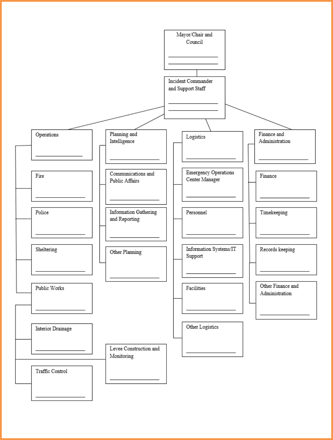
102
ORGANIZATIONAL
CHART
Public Works
Director
Police Chief
Building Inspector
City Clerk
Retired Public Works
Director
City Attorney
Deputy Fire Chief
Asst. Police Chief
Red Cross
Asst. Pub. Works
Director
Engineering
Consultant
Fire Chief

103
CHAPTER 5
OUTSIDE CONTACTS
Name
Phone
Alternate Phone
Email or Website
Key Websites
National Weather Service
USGS
Other
Utilities
Water
Sewer
Gas
Electric
Telephone
Cable/Communications
Other
Last Updated: 1/3/18

104
OUTSIDE CONTACTS (CONTINUED)
Name
Phone
Alternate Phone
Email or Website
Mutual Aid Contacts
County
County Emergency
Management
County Sheriff
Other
Last Updated: 1/3/18

105
OUTSIDE CONTACTS (CONTINUED)
Name
Phone
Alternate Phone
Email or Website
State
State Emergency
Management/Homeland
Security
State Duty Officer
Dept. of Natural
Resources
Dept. of Transportation
National Guard
Other
Federal
Corps of Engineers
FEMA
NRCS
HUD
Other

106
Last Updated: 1/3/18
OUTSIDE CONTACTS (CONTINUED)
Name
Phone
Alternate Phone
Email or Website
Other
Red Cross
Salvation Army
Volunteer Organizations
Ham Radio Operators
Local Churches
Other
Last Updated: 1/3/18

107
CHAPTER 6
FLOOD ELEVATIONS AND HISTORY
• The nearest river gage is near the Main Street Bridge.
• The difference between the river stage and the elevations in our community is 616 feet.
That is, when the river stage is at 14 feet, that is equivalent to an elevation of 630 feet at
the Main Street Bridge.
• The elevation datum for surveys in our area is NAVD88. This differs by 1.2 feet from the
datum of the river gage, which is NGVD29.
• The following items should be noted for future flood fights:
- A list of tasks is included in Chapter 7.
- The downtown area is low and most of the businesses have basements.
- The Main Street bridge has had ice jams that were broken up with an excavator
sitting on the bridge.
- The wastewater treatment plant needs to be sandbagged at river stages above 634.
• Attached are the following maps and graphs:
- Floodplain map (possibly from flood insurance study)
- Inundation map, both with and without permanent or temporary levees
- Map of permanent or temporary levee system
- Hydraulic profile

108
FLOODPLAIN MAP
INUNDATION MAP
MAP OF LEVEE SYSTEM
HYDRAULIC PROFILE

109
CHAPTER 7 Page 1 of ___
TASK LIST
This table is a summary of what actions need to be taken, the order they should be taken, and an
estimated river stage at which the activity should happen. It also serves as the table of contents
for the next set of worksheets. After each flood this list should be revisited to see if changes are
recommended.
River Stage
Task
Notes
Pre-Flood
Get contract in place for
pumps for when
stormwater discharges
into the river are closed.
Requires Council approval.
Pre-Flood
Get contract in place for
technical assistance from
Engineering Consultant.
Contract includes surveying and high water
marks. Requires Council approval.
Pre-Flood
Confirm sandbag
inventory
5
Close gates at stormwater
discharge into river (3
locations).
Allow ½ day since may be iced in and need to be
streamed out.
8
Remove park benches
along river.
10
Road Closure at 2
nd
Ave.
Requires detour signs.
12
Barricades for Main Street
Bridge approach, which
goes under water at stage
14.
14
Monitor for potential ice
jams at bridge and have
excavator available.
16 Road closure at 2
nd
Ave.

110
TASK LIST (CONTINUED) Page ___ of ___
River Stage
Task
Notes
18
Sandbag waterwater
treatment plant.
Ready materials and personnel at stage 14 to
allow suffiecient time to build closures
18
Contact Railroad
regarding potential track
closure.
19
Sandbag municipal well.
21
Top of levee at 9
th
Street.
21
Consider evacuation of
low lying areas.

111
TASK WORKSHEET
TASK NO. 001 Page 1 of ___
TASK TITLE:
Close Gates to River
River Stage
5
Task Description
Close gates on storm water discharges into
river (3 locations).
Cautions:
Allow ½ day since may be iced in and need to
be steamed out.
Photos:
Detailed Task Description:
There are 3 gates that need to be securely closed before the river stage comes up. They are
often iced in or may have debris blocking them from completely closing. The 3 gates are
located as follows:
1) Approximately 15 feet down the riverbank, near the intersection of 4
th
and Elm.
2) Behind the Quick Fix Shop on Forest. May need to ask the Quick Fix (Steve 724-8853) to
move parked vehicles.
3) Near the Main Street Bridge on the East side. May need to plow approach to reach.
Equipment and Personnel Needed:
Two people, one-half day, pick-up with plow, portable steamer, hand tools.

112
CHAPTER 8 Last Updated: 1/3/18
SUMMARY OF SHELTERS
The following locations are identified for shelters: short term, long term, and for pets.
Location Elevation
Point of
Contact
Phone
Numbers
Email
Short -Term
Lutheran
Church
1460
Rev. Rick
Rob
721-444-1212 [email protected]
High School 650
Supt, Bob
Williams
St. Mary
Catholic
Church and
School
652
Rev. Mark
Johns
Long-Term
Pets

113
CHAPTER 9
EVACUATION
If flooding should require an evacuation, the information would be conveyed to the public as
described in the chapter on communications. Depending on the extent of the flooding, the
evacuation may be designated by zones, as shown on the attached map.
The evacuation routes are as follows:
• First. Proceed out of town to the North, using Hwy 10.
• Second. Proceed out of town to the West, using Hwy 155.
The areas to avoid are:
• Low bridge
• Location of flooded roads
• Flooded underpass
• Road and railroad closures
Individuals that are included on the Special Needs Registry, maintained by the Fire Department,
will be contacted individually to assure their evacuation.
MAP OF EVACUATION ZONES AND ROUTES

114
CHAPTER 10
UTILITIES
Contacts for all utilities are included in Chapter 5. This chapter can be used for any additional
notes on issues with utilities that should be noted.
1. The levee along 9
th
Street cannot be raised without raising the crossing power lines.
2. The road closure on 6
th
Street crosses a gas line. Contact Minnkota to shut off valves
on either side of the closure.
3. Closure of the railroad tracks is intended only during extreme events as it will stop
all train traffic. Discussions should begin well in advance of the possible river rise.

115
CHAPTER 11 Last Updated: 1/3/18
CRITICAL FACILITIES
Name of
Facility
Address Elevation
Point of Contact
Name Phone
Alternate
Phone
Email
Anywhere
General
Hospital
1689 12
th
Ave S
Anywhere, MN
1463 Mary Williams
466-398-
5445
321-969-
5236
Elementary
School
High School
Waste Water
Treatment Plant
Power Plant
Quiet Acres
Nursing Home
Additional Notes:

116
CHAPTER 12 Last Updated: 1/3/18
HAZARDOUS MATERIAL LOCATIONS
Name of
Facility
Type of
Materials
Address Elevation
Point of Contact
Name Phone
Alternate
Phone
Email
Peterson
Farm, Inc.
Pesticides
101 45
th
St SE
Anywhere, MN
1459 Jim Peterson
460-587-
4236
Anywhere
AgChem
Pesticides,
Fertilizers,
Propane
Water
Treatment
Plant
Water
Treatment
Chemicals
Sunoco
Gas
Station
Gasoline,
Diesel
Ogden
Propane
Co.
Propane
Tanks
Additional Note:

117
CHAPTER 13
COMMUNICATIONS
1. The objective is to provide concise information to the public in a timely manner through
multiple media.
2. Although the Mayor will usually be the face in front of the camera or the voice on the
radio, the designated spokesperson will be the City Attorney. All press releases or
information posted to the internet should be coordinated through the designated
spokesperson.
3. The email, phone number, and fax numbers for the local radio and television stations are
listed below.
• KFLP
• KRDQ
• KS101
4. Key messages will be sent out on Reverse 911 when appropriate. Prior to the beginning
of the flood season, the public will be encouraged to register their cell phones with the
reverse 911 system so they receive the notices.
5. The City will make maximum use of social media to the extent practical. This will
include frequent updates on Facebook, Twitter, and Snapchat.
6. All of the radio systems within the City can talk to each other. Both the Police Dept. and
the Fire Dept. have radios that can also connect with the County and the State Duty
Officer.
7. For resources beyond the capacity of the City, requests will be submitted through the
County EOC. The County EOC will enter the requests using Web EOC, the Incident
Management Software. The Point of Contact is the County Emergency Manager.
8. In an extreme event such as an ice storm during a flood event, it may be necessary to rely
on ham operators. A local ham operator, Sam Perkins, 651-233-1543,
[email protected] has volunteered to help facilitate communications if
needed.

118
9. The City EOC has a speaker phone that can be used for conference calls. A 1-800
conference line can be activated which would allow council members and city staff to call
in from home to get current updates.

119
CHAPTER 14
TRAINING
To assure the readiness of the flood team, the following training is recommended to be
completed by key personnel, including:
• Mayor or Chairperson
• Council Members
• Incident Commander
• Chiefs of Operations, Planning, Logistics, and Financial
• Police Chief
• Fire Chief
• Public Works Director
Most of the training is available online or through the state. The County is also a good source of
available training. Additional opportunities for training will be pursued as budgets allow.
The following classes are recommended for most of the flood team:
• National Incident Management System
• Incident Command Systems
• Flood fighting training offered through the State EOC or equivalent class
The following classes are recommended for at least one representative of the flood team:
• National Flood Insurance Program
• Social Media in Emergency Management
• Mitigation Planning for Local and Tribal Communities
• Introduction to Hazard Mitigation
• Emergency Management for Senior Officials
The City Clerk will keep a spreadsheet of all the training completed by the Team and report gaps
to the City Council.
As part of ongoing readiness, the team will annually conduct a one-half day table top exercise in
February. This will allow the team to identify any shortcomings in resources or information and
take action before flood season.

120
CHAPTER 15
LESSONS LEARNED
It will be the practice of this community to have a meeting after every flood fight to capture what
worked and what didn’t work and update this plan accordingly. A summary of lessons learned
to date are captured below:
2006 Flood:
• Have the Council declare an emergency earlier.
• Have contracts for pumps and surveying, (as well as engineering technical assistance) in
place prior to the flood season.
• Anticipate and prepare for ice jams at the Main Street Bridge.
• Have an updated contact list for utility companies including the railroad.
2013 Flood:
• Be prepared for a great demand for sandbags.
• Be ready to plow and remove fencing to sandbag around the wastewater treatment plant.
• Once the gates to the storm water discharge lines into the river are closed, pumping will
need to happen during every rain event.
• Identify the Incident Commander prior to flood season.

121
APPENDIX
1. Sample Resolution
2. Mutual Aid Agreements
3. Sample Press Release
122
APPENDIX D
GLOSSARY AND ACRONYMS
123
Glossary
1. Call Tree. A means by which a large group of people can be contacted in a short time.
The plan is designated ahead of time and each person calls a small number of people who
in turn each call a small number of people until everyone is contacted.
2. Critical Facilities. Locations that provide essential services and functions such as
hospitals, nursing homes, fire stations, water and sewer treatment plants.
3. Elevation Datum. The basis for surveyed information. Elevations are based on
benchmarks that were established at different times over the years and can vary slightly.
Comparing river stages in one datum with surveyed ground elevations in another datum
can result in critical discrepancies.
4. Emergency Action Plan. A step by step plan that addresses how a community or tribe
will response to all aspects of an emergency, in this case a flood.
5. Emergency Declaration. The action a political body such as a council, state, or nation,
takes in the event of an emergency in order to be eligible for assistance from emergency
programs.
6. Evacuation Zones. Designated divisions of a community based on elevations, risk of
flooding, and evacuation routes, so that an evacuation can be more specifically directed.
7. Flood or River Gages. Gages that provide data on the water levels in the river. These
are usually operated by the National Weather Service or the United States Geological
Survey agencies and the information is available on the internet. Some may be located
on remote bridges and need to be manually read.
8. Floodplain Mapping. A program available through FEMA that identifies areas of flood
risk in a community. The mapping is associated with an insurance program and local
zoning ordinances.
9. Hazard Mitigation Grant Program (HMGP). A FEMA program by which funds are
made available to the State as a Grantee to reduce future flood risks such as removing
homes from the floodplain, and other risk reduction and mitigation measures.
10. Hazardous Materials. Any materials that corrode other materials, explode or are easily
ignited, react strongly with water, are unstable when exposed to heat or shock, or are
toxic to humans, animals, or the environment.
124
11. Hydraulic Profile. The slope of the water in the river. The profile can be impacted by
the grade of the river channel as it flows downstream but also by water backing up behind
bridges.
12. Incident Command System. A system created to better manage an emergency response
across multiple jurisdictional boundaries. Some features include common terminology,
integrated communications, and unified command.
13. Inundation Maps. Maps that identify the areas that would be flooded for a particular
size flood event. Different maps for different levels of flooding are useful, but the one
percent flood is the most common event used in FEMA floodplain mapping.
14. Mitigation Planning. Identifies policies and actions that can be implemented over the
long term to reduce risk and future losses from hazards. These mitigation policies and
actions are identified based on an assessment of hazards, vulnerabilities, and risks. The
public and a wide range of stakeholders should be involved in the planning process.
15. Mutual Aid Agreements. Agreements between communities, tribes, or agencies to
share labor, equipment, and resources during an emergency. Fire departments assisting
each other are a well-known example.
16. National Flood Insurance Program. A federal program created by Congress and
managed by FEMA. The purpose is to mitigate future flood losses nationwide through
sound, community-enforced building and zoning ordinances and to provide access to
affordable, federally backed flood insurance protection for property owners.
17. National Flood Insurance Community Rating System. A system within the FEMA
flood insurance program that recognizes community efforts beyond those minimum
standards and reduces flood insurance premiums for the community’s property owners.
18. National Incident Management System. A system developed to provide uniformity
and consistency across all levels of government during a response.
19. One-Hundred Year Flood. A term frequently used to describe a flood event that has a
one percent chance of occurring in any given year. The term implies that it is a once in a
lifetime event, which is not an accurate representation of the probability.
20. Reverse 911. A communications system that allows for pre-recorded messages to be sent
to all phones in a specified geographic area.
21. Special Needs Registry. A means for identifying elderly or vulnerable persons that may
need additional assistance during an evacuation.
22. Storm Water Plugs. Devices that are placed in storm water pipes in manholes to
prevent floodwaters from the river from backing up into the community.
125
23. Tabletop Exercise. A process by which various scenarios are presented for discussion
and the group of flood personnel talk through the steps and possible challenges.
24. Topographical Mapping or Topo. Mapping that shows elevations and contours of an
area.
25. Web EOC. An on-line system used by FEMA and a number of states for tracking
requests for resources and the status of flood responses in real time.
126
Acronyms
1. ASHTO Association of State and Territorial Health Officials
2. BIA Bureau of Indian Affairs
3. DHS S&T Department of Homeland Security Science and
Technology Directorate
4. EMAC Emergency Management Assistance Compact
5. EOC Emergency Operations Center
6. EPA Environmental Protection Agency
7. FEMA Federal Emergency Management Agency
8. GIS Geographic Information Systems
9. HUD Housing and Urban Development (Federal Agency)
10. ICS Incident Command Systems
11. NAVD88 North American Vertical Datum of 1988
12. NGVD29 National Geodetic Vertical Datum of 1929
13. NIMS National Incident Management System
14. NRCS Natural Resources Conservation Service
15. NWS National Weather Service
16. RACE Radio Amateur Civil Emergency Services
17. USGS United States Geological Survey
18. VSMWG Virtual Social Media Working Group
