824 SD99
CONTENTS
Preface
1
PART 1: INTRODUCTION AND BACKGROUND
4
INTRODUCTION
t>. , 4
POLICY DEVELOPMENT
IN
SUDAN
4
OBJECTIVES
4
POLICY DEVELOPMENT PROCESS
:,,,. 4
FORMAT
OF
DOCUMENT:
5
WATER
IN
SUDAN
5
INTRODUCTION.
5
Hydrological Cycle
6
WATER
AVAILABILITY
IN
SUDAN
7
Introduction
7
The Nile System
7
Non-Nile Streams
and
Wadis
8
Groundwater
8
Summary
of
available water resources
8
EXISTING POLICIES AND LEGISLATION
, 9
FRAGMENTED POLICES AND LEGISLATION'S BEFORE 1992
9
COMPREHENSIVE POLICIES AND LEGISLATIONS AS
OF
1992
9
DIVISION
OF
FEDERAL AND STATE RESPONSIBILITIES
11
OBSERVATIONS AND RECOMMENDATIONS
11
PART 2: WATER POLICY...
12
INTRODUCTION
12
OVERARCHING POLICY PRINCIPLES AND OBJECTIVES
13
WATER RESOURCES....
14
SURFACE WATER
[ 14
Key issues
and
problems
14
Policy principles
and
objectives..:
15
GROUNDWATER
', 16
Key issues
and
problems
1°
Policy principles
and
objectives:
•. 18 •
UNCONVENTIONAL
WATER RESOURCES
19
Policy principles
and
objectives
19
UTILIZATION
I
r
. »....
19
WATER SUPPLY
&
SANITATION
19
Key issues
and
problems
••
20
Policy principles
and
objectives
• 27
AGRICULTURE
AND LANDUSE
• 22
Key issues
and
problems
--.
Policy principles
and
objectives
"""of
HYDROPOWER • 24
Key issues and problems • • • ~*
Policy principles and objectives ff
INDUSTRY
• • ••:::• *|
Key issues and problems • ~|
Policy principles and objectives ^
Implications •••• JQ
NAVIGATION
•'O
BOX
93190,2509
AD
THE
8«rtMm National Water Policy
Tel.:
+31 70 30 689 80
Fax: +31 70 35 899 64
BARCODE: . Q
Page 2
Policy principles and
objectives
26
FISHERIES
: 26
Policy
principles
and
objectives
; 26
WATER AND THE ENVIRONMENT
j 26
THE
ENVIRONMENT AS
THE
RESOURCE BASE
I 26
POLLUTION
CONTROL
[ 27
CATCHMENT
DEGRADATION
:
27
BIODIVERSITY
AND
WILDLIFE
[ 27
Policy
principles and
objectives
[ 27
THE INTERNATIONAL DIMENSION
28
Policy principles
and objectives
.: 29
DISASTER MANAGEMENT AND PUBLIC SAFETY
1 29
NATURAL DISASTER MANAGEMENT i 29
Policy
principles
and objectives
29
.
PUBLIC SAFETY
I. 30
\ ^
Policy principles
and
objectives
30
_
INSTITUTIONS, CAPACITY BUILDING AND TECHNICAL ASSISTANCE
32
INTRODUCTION
32
INSTITUTIONAL DEVELOPMENT
32
Balanced
management
32
Information
management.
32
Research
33
CAPACITY
BUILDING
33
EXTERNAL
ASSISTANCE
....33
PART
3:
CONCLUSION
34
Abbreviation
and
Acronyms
ADS Area Development Schemes
ARS Area Rehabilitation Schemes
BCM Billion Cubic Metres
CBD Convention
on
biological Diversity
CCD Convention
to
combat Desertification
CCC Convention
on
climate Change
ESTAC Ethiopia and Sudan Technical Advisory Committee
FAO Food and Agriculture Organization
GWH Giga Watthour
M
& E
Monitoring and Evaluation
MIWR Ministry
of
Irrigation and Water Resources
MW Mega Watt
NCS
The
National Comprehensive Strategy
NCWR
The
National Council
for
Water Resources
NGO Non-government Organization
NWC
The
National Water Corporation
OM Operation and Maintenance
PM Pest Management
RWH Rain Water Harvesting
SWCs
The
State Water Corporations
TECCO NILE Technical Committee
for
Nile Countries
UNDP
The
United Nations Development Programme
Sudan National Water Policy Page 3
Part
1:
Introduction and Background
Introduction
Water Policy Development In
Sudan
Tli9_d_^£^jatiifinLQlj)o!ic\(iJnjSudjyj
,Js_anJrn-
portant element in thgjjrggress^ofi.Suda^pSjc^
Deye|_opment. whilst attainrnqTintemational ex-
j^rience£wjTlJ)ej3a^sed.^
its
"of the Sudanese people. The nationai water
pPljcjjrpreseji^
geth'er, for thejfirejt
jtirjie,.
policies, which are.re-;
fafea"'fo~mariy"aspects of water, including re-
sources, utilization protection and management
integrated document. .
Be_sid_es_^any__p^y^mmenta|.,. asp^s the
document also covers a wide range of other
activities such as agriculture, forestry, industry,
health,
energy and transportation. The docu-
ment comprises an ongoing process of policy
and legislation development in Sudan, dating
back to a number of years. Thfi_suggested
policies needjo by dynamic in order to cope
wjth.
the requirements of the country and its
people, bothjn_t(rne^and.space. A5_tbe....pfes:_*
sure ^TR^mjtedjiatgraLrespurces. increases,..
the_policies should.be.,developed and manipur.
latetl to ensure^;tjh.a.tjmat.erjs^sed,fa|r1y,and Ks
resources '(jrplectssLagaSnst.poiiuti6n
1
,.'degrada-..,
tioh and mis-oise. Thus there will be an pngo-;
incpcycTeTof' policy development, ifnplementa-
jion and review. The main elements of this pol-
icy may be implemented as soon as possible.
However, periodical reviews should be carried
out when necessary in accordance with the
cycle of policy development
Objectives
The objectives of the national water policy are
as follows:-
• To bring together and clarify existing policy;
• To review and adapt water policy to meet
changing circumstances within the country;
djarLareptaperly..
managed,., protected,
and
•J • To provide the basis for the ongoing devel-
opment of water related regulations and
legislation;
i • To strengthen and rationalize water related
institutions in both the public and private
sectors in Sudan.
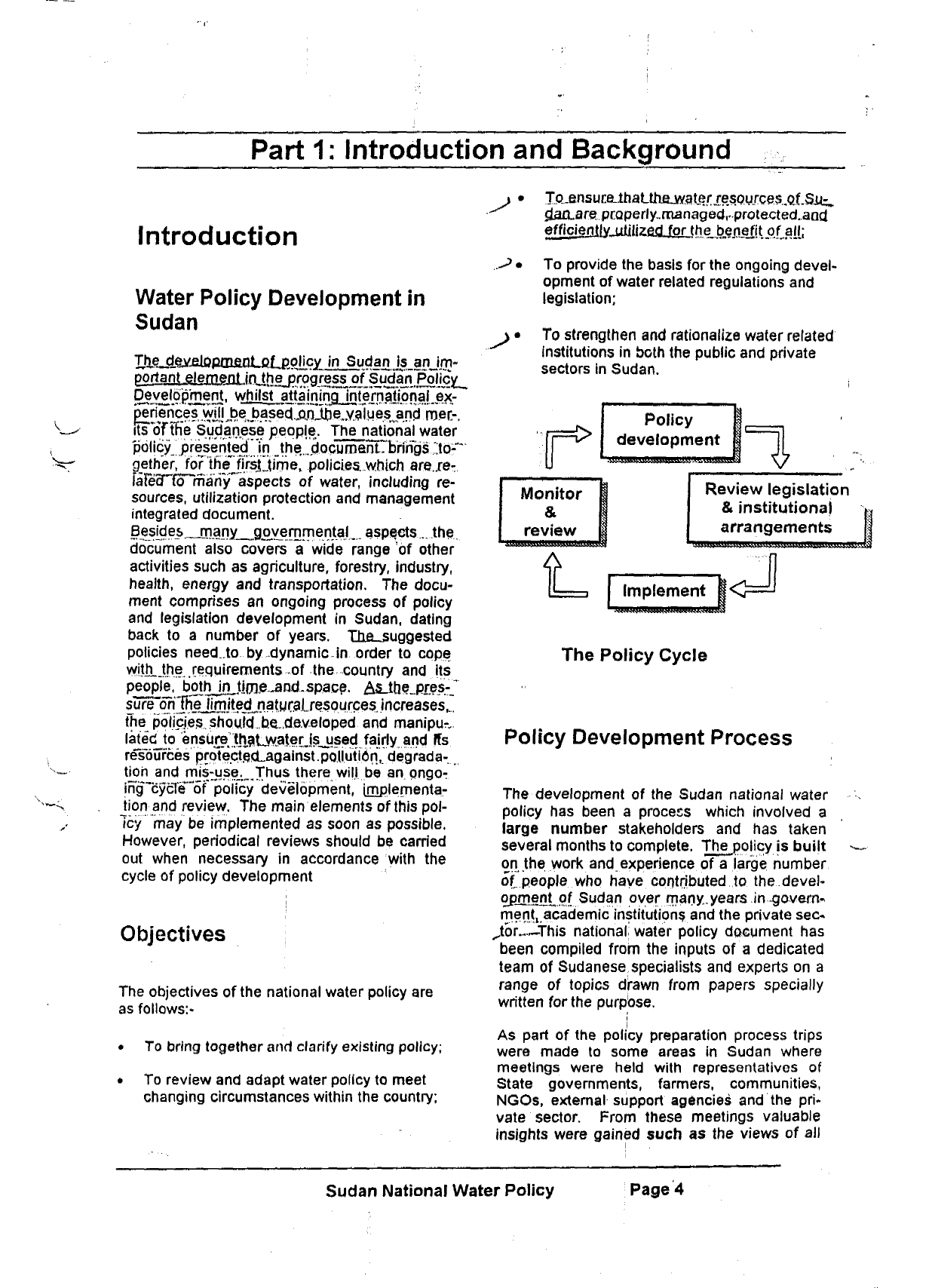
r
Policy
development
Monitor
&
review
Review legislation
& institutional
arrangements
Implement
The Policy Cycle
Policy Development Process
The development of the Sudan national water
policy has been a process which involved a
large number stakeholders and has taken
several months to complete. The policy is built
on the work and experience of a large number
of people who have.contributed,.to. the devel-
opjneulof Sudan over many.years in -govern-
mentj academic institutions and the private sec*
^tbr this national water policy document has
been compiled from the inputs of a dedicated
team of Sudanese specialists and experts on a
range of topics drawn from papers specially
written for the purpose.
i
i
As part of the policy preparation process trips
were made to some areas in Sudan where
meetings were held with representatives of
State governments, farmers, communities,
NGOs, external support agencies and the pri-
vate sector. From these meetings valuable
insights were gained such as the views of all
Sudan National Water Policy
Page 4
sectors of the population and how water directly
affects their lives.
The initial draft of the national water policy was
referred to a large number of technical ex-
perts both within Sudan and in the international
water sector for comment. Wherever appropri-
ate these comments are incorporated into the
policy. In addition, a national symposium was
held to provide an opportunity for comment
and input into the policy formulation process.
In addition, draft copies of the document were
widely circulated to all federal ministries and
state governments in Sudan.
The Government of Sudan wishes to acknowl-
edge with thanks all those persons who con-
tributed to the development of this national wa-
ter policy document. The following persons
deserve particular gratitude of the people of
Sudan.
• His Excellency Kamal AM Mohamed, The
Minister of Irrigation & Water Resources;
i
• Dr. Osman El Tom Hamad, the National
Water Policy Project Coordinator;
• The team of national consultants: ;
• Dr. Ahmed M.O. El Mufti
• Prof. Hassan Abdel Rahman Musnad
• Dr. Mohammed Ahmed AN Dingle
• Dr. Hamid OmarAli •;•>
• Eng. Mohammed El Mahdi Siddig
• Ms. Intisar Ibrahim El Sadig
• Prof. Ahmed Ali Salih
• Mohamed Ahmed Ibrahim Ghanim
• The Resident Representative of the Sudan
office of the Food & Agriculture Organiza-
tion (FAO) of the United Nations for techni-
cal support.
• The Resident Representative of the Sudan
office of the United Nations Development
Programme (UNDP) for financial support
Format of Document:
One of the most important objectives of this
policy document is to ensure that the national
water policy of Sudan is clear, simple and ac-
cessible to ordinary people in the country. More
often than not government policy is unclear
because it can only be found embedded in
complicated legislation and lengthy documents
which makes the implementation of policy very
difficult. In line with international trends, the
Sudanese Nationjl Water Policy has been
purposely written in ordinary language and is
addressed to all the peoples of Sudan.
The document begins with an introduction to
the objectives of the policy. The introduction is
followed by an insight into the importance of
water in Sudan, which provides an overview of
the role of this most important natural resource
in the development of the country.
This policy document is a baseline document
which it forms part of an ongoing process of
refinement and development of policy and leg-
islation in Sudan. The next section in the
document therefore provides the background to
existing policy and legislation from which this
policy is developed.
The main policy issues of the document may
be found under the chapter entitled "Water Pol-
icy". This section includes the main policy
prin-
ciples and statements for the proper manage-
ment, utilization and development of water re-
sources in Sudan.
The institutional framework through which wa-
ter resources in Sudan are managud is a key ,\
element in the implementation of water policy,
together with the building of the required capac-,
ity within these institutions and the country as a
whole.
Policy relating to these matters follows
the-,water policy section.
The document concludes with recommenda-
tions for the development of a strategic plan for
implementation of the new policy.
Water in Sudan
Introduction
Water has an impact which extends on most.of,
thejinajor sectors of life, hence
the,
statement in,
^-9.yra.n_.that Allah has made from water"
everxJi.yjng",
thing.
"Water is Ufe" is "a
Veil"
known saying. Thus, any water policy is inevi-
tably complex and overlaps with policies in
other related fields, often crossing international
boundaries. Policy Is also dynamic and
evolves with changes in supply and demand
Sudan National Water Policy Page 5
V
parameters, the surrounding environment, ad-
vancement in Knowledge and feedback from
previous policies.
Water has
an
jsssentjalj.
role...
jn sustaining-life
alid^iyejopment in"arid and sjsmi-arig_.rfigions.-
Thje
Jacation.
of Sudan
qi
;
trie heart "of Africa and.
its generally flat l^jagraphy
h^s...
resulted in
more Jtoari
half its area being desert or,,,semi- -
desert. " """'
The northern half of Sudan extends from the
capital Khartoum, where the rainfall is 20Qmm
per annum, northwards to the border with Egypt
where there is no rainfall. Where it rains the
rainy season is limited to two or three months
with the rest of the year virtually dry. Rainfall
usually occurs in isolated showers which vary
considerably in time, location and from one
year to another. The coefficient of variation of
e annual rainfall in this northern half of the
country could be as high as 100%.
on water as a
In the quarter south of the country's centre, the
annual rainfall barely exceeds 700mm per an-
num,
concentrated in only four months from
July to October. Rain-fed agriculture in Sudan
is mainly practiced in this quarter. As the coef-
ficient of variation in annual rainfall in this re-
gion is around 30% and the dry season extends
for about eight months, the area cultivated and
the productivity varies widely from one year to
another.
n the most southern quarter, where the annual
rainfall exceeds 700 mm, the area is dominated
by extensive wetlands and inhabited by tsi-tsi
fly and other insects, which are hazardous to
humans and livestock. Perennial sources of
water, which are shared with neighbouring
countries; are therefore the main reliable water
resource of the country, i
Although Sudan is the largest country in Africa,
with an area of 250 million hectare, its current
population is approximately 30 million. More
than half that population live on just 15% of the
land along the Nile river, Most of the rest of the
population live in towns and around water
sources away from the Nile.
Similar to most developing countries, ab
ture.
whjc.fi..d,Qnuoates....the, xountry.'suecoaamic.
growth and deyej.opme.ot. consumes the major
part brSudan^xana^le,water. Wj^ei.Usraand,
fo^fin^ingy'rnunicipal and,jn.d,.MSlrial .ys,gs..arfiL
"presently lessJhafi.Q.% but are on
the;
increase,
H^rbpowerjjene^
heaithT trie environment and other socio-
resourc&tiase^-**
Hydrological Cycle y
The hydrological cycle is a natural phenome-
non through which all water, which is so essen-
tial for development and human wellbeing, is
constantly moving. Through the cycle all water
is inter-related. Rainfall, which is the result of
evaporation by the sun, feeds streamflow and
groundwater recharge. An impact on one part
of the cycle has effects on other parts. These
effects may be local or global, where, for ex-
ample,
activities in one part of the world cause
climate changes in another. The development
of a new national water policy in Sudan recog-
nises the reality of the hydrological cycle and
the interaction between its different compo-
nents.
This results in an integrated national
water policy and is consistent with international
standards.
Whilst the natural hydrological cycle is ex-
tremely complex and not fully understood, its
basic components may be illustrated diagram-
matically (See Fig. 1).
Enormous volumes of water are involved in the
water cycle. There are about 1.4 billion cu km
of water on the earth, slightly more than 97
percent of which is ocean water and is there-
fore salty. However, because the water that
evaporates from the ocean is almost free of
salt, the rain and snow that fall on the earth are
relatively fresh. Fresh water is stored in gla-
ciers,
lakes, and rivers. It is also stored as
groundwater in the soil and rocks. There are
about 36 million cu km of fresh water on the
earth.
The world's two main reservoirs of fresh water
are the great polar ice caps, which contain
about 28 million cu km, and the ground, which
contains about 8 million cu km. Almost all of the
world's fresh ice is found in the ice caps of Ant-
arctica and Greenland. All the world's rivers
and freshwater lakes hold about 120,000 cu km
(about 0.3% of the available fresh water).
Ironically, a favorite expression in hydrology is
that- people expect water to be cheaper than
rt
Sudan National Water Policy
PageQ
Water Availability in Sudan
Introduction
Water resources in Sudan are very limited.
They comprise rainfall, groundwater and riyer
\f
flows,
all of which are inter-related as part of
the natural hydrological cycle. I
The erratic nature of rain and its concentration
in a short season places Sudan in a vulnerable
situation,
especially in rainfed areas^,Surface
shared with neighboring countries. The Nile
River, which is shared between 10 countries, is
the primary source of Sudan's water. The four
main non-Nile streams are also shared with
neighbors. These are Gash and Baraka which
flow from Eritrea and Azum and Hawar which
are shared with Chad. The largest groundwa-
ter aquifer, the Nubian Sandstone system is
shared with Chad, Libya and Egypt.
The Nile System
Ten countries share the Nile, which dominates
the map of Sudan. These are: Burundi, De-
mocratic Republic of Congo, Egypt, Eriteria,
Ethiopia, Kenya, Rwanda, Sudan, Tanzar
and Uganda.
The Nile is the dominant geographical feature
of Sudan as around 70% of the area of the
1
country is situated within the Nile River catch'
ment area/ On the other hand, although ten
countries share the Nile, about 60% of its
length lies within Sudan. The share of the Nile
waters utilized by Sudan is substantially less
than this ratio. Out of an average annual flow
of 84 billion cubic metres (bcm) of water that
reach Aswan in southern Egypt, 10 bcm were
estimated for evaporates from the High Aswan
Dam,
and 55.5 bcm flow downstream as
Egypt's share according to the 1959 Nile Wa-
ter's Agreement between Sudan and Egypt.
Sudan is allowed to abstract up to 18.5 bcm
according to the agreement, which is 22% of
the Nile flow.
The three main tributaries of the Nile'unite iff
Sudan and the Nile leaves as a single arteiy
through the Sahara Desert to Egypt. The Blue../
Nile and the White Nile join at the capital Khaj-
Hoiim carryingr54"and^7"bcm of water respec-
tively as a long term average, t
320 kilometres north of Khartoum bringing in
about 12 bcm of water. Thus, the annual aver-
age flow of the Nile in central Sudan is around
93 bcm. Approximately 10% (9bcm) are lost
along the journey through the Sahara Desert
leaving 84 bcm of water to reach Aswan. The
Sudanese share, which is 18.5 bcm of the Nile
water measured at Aswan, is equivalent to 20.5
bcm when measured in central Sudan, again
22%
of the flow there.
Sudan has a unique position in the Nile system.
It is a sink, a path and a source of the Nile. It is
on one hand one of the two dry downstream
countries, with Egypt sharing the fate to act as
a drainage basin and a sink for the sediment
and debris flowing down from the highlands. It
also embraces 60% of the Nile within its bor-
ders.
On the other hand, it contributes to the
flow of the Nile from Bahr^EljShazal, Bahr El
Jebel and Pibor basins asTwell
as"
the'seasonal
streams which join the Nile along its journey to
the north.
Sudan has also the potential to increase the
Nile flow through conservation of the river flow
through the wetland areas in its south. If ap-
propriate measures are taken to minimise
envi-
ronmental and social impact in the wetland ar-
eas,
the Nile flow might be increased by an-
other 12 bcm.
y
The amount of sediment carried down to Sudan
during the flood season of one year appears to
be influenced by the rainfall over the upper
catchment during previous years (Hamad and
Mohammed, 1986), It was noticed that when a
wet year follows a succession of dry years, the
sediment concentration is higher than normal
and the flood flow recedes at a higher rate.
This is particularly true for the Blue Nile and
Atbara River flood flows. A succession of dry
years were experienced from 1978 to 1987
while four distinct high floods occurred after
that in the years of 1988,1994,1996 and 1998.
Such a phenomenon has to be addressed in
the policy development and planning process.
Sudan is seriously affected by the dry years
because of its limited storage facilities. Con-
versely, the high floods destroy infrastructure
and increase the effects of sediment and
scourge along the river banks. Mitigation of
floods to alleviate their adverse effects on hu-
man life and property has to be reflected in pol-
icy developments and planning as
well.
I
The combined river is named the Main
which is joined by Atbara fiver at Atbara"lbwH
Sudan National Water Policy
Page 7
Non-Nile Streams and Wadis
The major four streams, which fall under this
category,
are
Gash
and
Baraka, which
are
shored
with"
'"Ernfefia."" and~A~iurn"and Hawar,
which
are
shared with Chnci.
The
combined"
How
of
these streams forms more than
one
third
the
total flow
of a!! the
streams which
are
not part
of the
Nile system. Flow from
the
non-
Nile streams varies considerably from one year
to another following
the
erratic nature
of the
rainfall
in the
region. Their total annual flow
varies from
3 to 7
berry They
may
flow
for a
fow d;jys
or
hours during
the
period from July
to
October
and are
usually
dry for the
rast
of the
year Most
of
these streams
are not
monitored
regularly
Monitoring
was
neglected
in
many streams
af-
ter
the
Decentralization; Act
of
1994 because
of
shortage
of
funds
or
lack
of
clarity
of
responsi-
bilities,
of
different government bodies.|#,s
any
planning requires sound temporal
and
spatial
data,
the
issue
of
scarce data
is
addressed
later in
the
policy document
Groundwater
The sedimentary Nubian sandstone
and Umm
Ruwabo formation
are the
main aquifers
in Su-
dan.
They extend
to a
deptrTrangihg'frSm 40
to
400 meters
and
have total dissolved solids
7a7igTng~lr6m
100 to
2,000
ppm.
Some
re-
search
was
carried
out by
experts funded
by
Germany
on the
Nubian Sandstone, which
is
shared &y...Qhad_.Jj:gypt, Libya
and
Sudan.
As a
result
of
this research
it was
concluded that
the
Nubian Sandstone groundwater
is
largely
of
fossil origin. Quantification
of
groundwater
is
difficult under
the
economic hardship facing
a
r
QPi
third world country lfKe*"Sudan without
the
assis-
tance from international agencies. Thus
the annual recharge
of
groundwater
is
difficult
to assess accurately.
It has
been estimated
to
be about 4.0 bcm.
\
Summary
of
available water resources
The current annual amount
of
water available.
to Sudan from
all
internal
and
external sources
Tmounts
to
about
30 bcm (Box
.1). This
is the
summation
of the
Sudan's share
of
the Nile wa-
ters according
to the 1959
Agreement with
Egypt (20.5 bcm),
the
average flow
of
t.hejion-
'
^iNiKT'stream^
groumjwaler (4.o"bcm).
H should bVnoted here that
a
good portion
of
the non-Nile flow
is
shared with neighboring
countries.
Evapo-transporation
in
Sudan ranges from
3000
to
1700 mm
per
year from
the
north
to the
south.
One hectare
of
a seasonal crop
in
cen-
tral Sudan needs
12
000
m'o?
water.
The 30
bcm
of
water available
to
Sudan
may
cover
2.5
million ha which
is
1%
of
the area
of
the coun-
try and less than
5% of
its arable
land.
If
more
than
one
crop
is
rotated
on the
same plot
or if
the country expanded
the
area covered
by per-
ennial crops,
the
area which could
be
irrigated
by the
30
bcm will
be
considerably less than
1%
of
the area
of
the country.
It
should also
be
noted that there
are
other uses
of
water, such
as municipal and industrial needs, which
are
expected
to
increase
at the
expenses
of
irri-
gated agriculture.: Moreover, harvesting all
the
water in
the
seasonal streams
is not
easy.
Also abstraction
of
the desired amounts
of
ground water may prove
to be
difficult
as ex-
plained later
.
Box 1
:
Internal and external water available
in
billion m
J
/year (Km'i /year)
Wat<jr Resources
Sudan present share form
the
treams
Renewable Ground Water
20.5
5.4
4.1
Seasonal pattern coupled with limited storage
|_fa £i|Uie s
!
I Highly variable, short duration flows which
are
difficult
to
monitor
or
harvest. Some
are
shared with neighbours
Present Total
Expected share from
n
olama-
tjon_of swamps
"Total
• '
...•:•.•:..:••;:;..;.:.•.::.•••:.:::;.:>;
'
30.0
TIT
36.0:
Deep water entailing high cost
of
pumping.
Remote areas
of
weak infrastructure
Capital intensive with considerable social
and
environmental cost
Sudan National Water Policy
Page
8
I ]
jL
C
f
Sudan may increase its share of the Nile wa-
ters by working with Egypt to conserve some of
the water which evaporates from the southern
swamps. The amount conserved should be
divided equally between the two countries as
stated in the 1959 Agreement. Despite the so-
cial and environmental impacts, which have to
be taken care of, such projects take time and
money because of their very large size. Work
on Phase I of the Jonglei canal has begun but
has been halted since 1983 due to security
reasons. Other projects might start after the
successful completion of Jonglei project.
As the rate of growth in population is 2.9 % an-
nually, and as the need tor water increases with
development, any possible increase in the
availability of water will be consumed as it be-
comes available. Thus the water shortage
situation is expected to continue. The de-
mands of other Nile Basin countries and those
sharing non-Nile streams with Sudan might in-
fluence the amount of water available and its
distribution in the region.
EXISTING POLICIES
AND LEGISLATION
c
e.
Organisation of the rotation of crops;
Obliging theilcenseeto'cuitivate crops making
bptimaluseoftrie waTers'pumped^jzuiaritie "
cence;
Annual fees to be paid for each licence.
In addition there are several other pieces of legisla-
tion which illustrate a variety of different policies.
These are shown on Box 2
Financing water use
Water is a source of life, so there is no policy for
selling water in Sudan. Therefore, under the Civil
Transactions Act of 1984, the landowner in a
Muzara lease shall hand over the land to the tenant
with its rights including the right to use the water and
the tenant bears the cost of irrigation canals.
On theJSeziraJcrigatjpni Scheme there is no policy
for full cost recovery for wateruse.Tn order tg meet
its financial obligations, the Scheme sometimes take
part of
the,
fees-for- water
and
tenet,*when
faced with
a deficit in the budget. The Government shall then
be obliged to finance the deficit. The fees for land
and water used to be determined by the Minister of
Agriculture in consultation with the Minister of Fi-
nance and National Economy (fees are determined
by regulations and not market forces). Tenants are
allowed to pay water and land fees after the end of
the season or even later.
Water policy and legislation development in
Sudan can be divided into two eras as follows:
Prior to 1992 when the polices and legislation
were fragmented, and post 1992 after a com-
prehensive review of polices and legislation.
This section provides a brief overview of these
developments.
.!
Fragmented polices and legislations, before
1992 '
The main water regulations in Sudan are
based on the 1951 Regulations, which are li-
censing regulations for pumping water from the
Nile according to the Nile Pumps Control Act of
1939 (repeated). Recent instruments have
modified the 1951 regulations, e.g. the Water
Resources Act of 1995. In the licensing policy
there are provisions for the following:
a. Solving disputes through arbitration;
b. pbiiging the licensee to maintain the canals
to avoid seepage:
Comprehensive Polices and Legislations as of
1992
Since 1992 the institutional and legal framework for
water resources development, utilisation and man-
agement in Sudan have been reviewed and revised
through the introduction of a number of instruments
as follows.
The National Comprehensive Strategy (NCS) of
1992
According to the National Comprehensive. Strategy
(NCS) of 1992, the irrigation and water resources
sector is considered as a sub-sector of the agricul-
tural sector. Its policy objectives and strategies are
defined as follows:
afiicient utiUzation-and development of
surface and groundwater resources;
Sudan National Water Policy
Page 9
BOX 2: Legislation before 1992
ACT
The Protection of Agricultural Tenants in
Gash Delta and Toker Act of 1928 and the
Agricultural Tenants Protection Act of 1950
The Fresh Water Fisheries Act of 1954
The Water-hyacinth Control Act of 1960
The Environmental Health Act of 1975
The Rahad Corporation established by the
Rahad Corporation Act of 1972
The Corporation established by the West-
ern Region of Savannah Development
Corporation Act of 1978
The Civil Transactions Act of 1984
'I
The Gezira Irrigation Scheme Act of 1984
The Irrigation and Drainage Act of 1990.
The High Council for Environment and
Natural Resources Act of 1991
OBJECTIVES
The protection of agriculture
tenants
To protect the freshwater fisheries of the Sudan and to
regulate and control fishing
:
To control and prevent the spreading of water - hyacinth
in rivers and waterways in Sudan
To preserve environmental health including provision and
preparation of public drainage and drain rain water and
sewage water. i
The development of the area allotted or acquired under
the Act for the promotion of agricultural production, and
efficient irrigation
a. To establish integrated agricultural and rural devel-
opment in the project area through the optimal utiliza-
tion of natural resources;
b. To develop water resources in the project area;
c. To rally the citizens, to cooperate with the Corporation
Regulates
the,
relationship between landowners and ten-
ants '!
To utilize the natural and agricultural resources of Gazira
,andto develop and promote them on a scientific and
commercial basis.
All irrigation and drainage activities require a licence from
he Ministry of Irrigation and water Resources (MIWR)
nclude the sustainable development of natural resources
and their optimal utilization, environmental protection in
co-ordination with State organs and public awareness. |
Building of dam on rivers other than the
Nile and on seasonal valleys.
• Addressing the problem of silt in reservoirs
, the enlargement of existing reservoirs
through increasing their height and the
construction of Qeyyjdaros;
• Eliminating thirst and develop safe water
supply networks all over the country; and to
procure water for human and animal life
completely by the end of the duration of the
NCS;
• Developing the water sector manufacturing
industry to supply water pumps, drilling
equipment, pipes, reservoirs and spare parts;
(practical steps have been taken in
this connection through the National Water Equip-
ment and Manufacturing co., the National Drilling
and Investment Co. and the National Water Re-
sources Development Co. established in 1994);
• Developing economic criteria for the utilization
of water in such a manner as to maintain a bal-
ance between the cost on the one hand and the
economic and social return on the other.
These issues and whether they have been put to
action formed an important source in developing this
national water policy.
Sudan National Water Policy
Page 10
The Ministry of Irrigation and Water Re-
sources (MIWR).
All water affairs were brought under one um-
brella - the Ministry of Irrigation and Water Re-
sources
( MIWR) . Section 10 of the Council of Minis-
ters Resolution dated 12 November 1995 de-
fines the powers of the national local point for
water resources -the
Ministry,
of Irrigation and..
Water Resources (Ml
VVR).
:
.
..Some of its
_
ma in ,
policy functions are ;,.-.
;>•
To assess,, formulate and develop the na-
tional plan for irrigation;
• To formulate polices for the use of water
resources and review and update such
policies according to new developments.
The National Council for Water Resources
(NCWR) i
The National Council for Water Resources
(NCWR), established in 1995 is headed by the
Minister of MIWR with representatives form
major suppliers and users of water nationally
and at state level. Its mandate includes the
following:-
• To formulate the general policy for water
resources;
• To formulate a long term federal plan for
optimal and balanced use of water re-
sources, and determine priorities.
The National Water Corporation
The National Water Corporation Act of 1995
has established a corporation with the following
main policy powers.
• Formulating the general policy for drinking
water at national level and protection of the
surrounding environment.
• Proposing legislation regulating the use of
water for drinking , the integration of such
use and associated training.
• Management of foreign aid for drinking wa-
ter.
The financial resources of the Corporation are
derived from three sources: allocations from
the government, the cost of work done or ser-
vices rendered by the Corporation and dona-
tions accepted by the board.
The Irrigation Water Corporation
The Irrigation Water Corporation was established by
the Council of Ministers to provide services in con-
nection with irrigation water and be financed by the
agricultural corporations, which collect the fees from
the farmers. However this corporation was dis-
solved in May 1999 so that irrigation services at the
minor canal level would be shouldered by each
irri-
gated scheme under the technical supervision of the
Ministry of Irrigation and Water Resources. The
Ministry is financed by the central governments to
maintain and operate the major irrigation infrastruc-
ture.
Division of Federal and State Responsibilities
Major federal development projects are considered
by the Constitutional Decree No. 14 as national
wealth,
to be managed at the federal level. The
Federal government shall ensure the participation of
the State Governments in the management of such
projects. Also the federal organs exercise powers in
relation to the national electricity network. The State
organs exercise powers in accordance with the fed-
eral plans, polices and legislation in relation to State
electricity networks and irrigation.
In the event of dispute arising about the residual
powers between a State and the federal govern-
ment, the dispute shall be referred to the court. Ac-
cording to the Constitution, the Constitutional Court
has the jurisdiction to decide upon claims concern-
ing conflicts between state and federal authorities
over their powers.
According to the Constitution oM998, the federal
government is responsible for,planning, regulating
and,executing jnter-state_waters and national elec-.-
tricity projects.. Each State exercises legislativer
executive and planning functions in non-transit wa-
ters and electric power within its boundaries.
Observations and Recommenda-
tions
Currently the water sector in Sudan, apart from the
NCS,
is governed by three overlapping legal re-
gimes:
• The first legal regime was established by the
Nile Pumps Control Act of 1939 and the 1951
Regulations made thereunder. That regime was
limited to the waters of the Nile and its tributar-
ies and was confined to control over the pump-
Sudan National Water Policy
ing of water from the Nile for the purposes
of cultivation.
The second legal regime which was estab-
lished by the Irrigation and Drainage Act of
1990 complements the first legal regime
and,
therefore, the Nile Pumps Control Act
of 1939 was not repealed. The two major
developments introduced by this second
legal regime were that it broadened the
scope of the existing legal regime to in-
clude drainage activities, and it has made
the Minister of Irrigation and Water Re<
sources the concerned authority. However,
the 1990 Act neglected making certain key
legal amendments, for example, the con-
cerned authority under the Nile Pumps
Control Act of 1939 is a Board chaired by
the Minister of the People's Local Govern-
ment which no longer exists. Also, the
1990 Act does not define the waters which
it should be applied.
The third legal regime which is currently in
force is the regime established by the Wa-
ter Resources Act of 1995. It has repealed
the Nile Pumps Control Act of 1939 while
keeping the 1951 Regulations. Also it has
not repealed the Irrigation and Drainage
Act of 1990. Therefore, there is an overlap
between the three legal regimes.
Other inconsistencies exist, for example the
MIWR has been given the power to licence
water pumping for irrigation under both the
Irrigation and Drainage Act of 1990 and the
Water Resources Act of 1995. and licens-
ing power is given to both the local authori-
ties under thel
951
Regulations and to the
MIWR under the Water Resources Act of 1995.
However, the third legal regime is more com-
prehensive as may be seen fromm the foiiow-
ing:-
• It applies to water resources and not to the Nile
alone,
and it has defined "water resources" to
mean surface and groundwater resources
whether crossing the national borders or not.
• It covers the use of water resources for all pur-
poses unlike the two previous legal regimes,
which were confined to irrigation and drainage.
The new purposes include consumptive use,
hydro-power generation and drainage.
• The institutions entrusted with the implementa-
tion of the 1995 Act are the NCWR chaired by
the Minister of IWR, the MIWR itself (and the en-
tities falling under its supervision) and the
States' organs which act under the powers
delegated to them by the MIWR.
In the light of these observations, it has become a
top priority to review and integrate existing policies
pertaining to water resources. One outcome of this
new water policy is to remove inconsistencies, re-
dundancies and contradictions which have devel-
oped over the years.
Within the context of a new integrated policy frame-
work, it will also be necessary to revise the existing
legal regime to remove redundancies and inconsis-
tencies.
PART 2: WATER POLICY
INTRODUCTION
Part 2 of the document contains policy for the
development, management and protection of
water resources in Sudan.
It covers a wide variety pf issues, most of which
have both common and specific policy ele-
ments. For this reason part 2 begins with a
section on over-arching policy issues which
apply to the sector as a whole and to most of
the individual components.
The overarching policy issues are followed by
the main specific areas of concern in water re-
sources development, management and pro-
tection,
set out according to the following cate-
gories:-
<p
Water Resources:- The Sudan has limited wa- Qt>
ter resources which need to be carefully man-
aged.
The section describes the various water
resources available for development and sets
out the policy applicable.
Water Utilization.- Water Is used in many dif-
ferent ways - for human consumption, agricul-
ture,
industry and municipal uses. This section
Sudan National Water Policy
Page 12
sets
out the
various uses together with policy
related
to
each type
of
utilization.
Water and
the
environment:- The natural en-
vironment
is
the source
of
all water and has
a
direct influence
on the
availability
of
water and
its quality. This section looks
at
policy
as it
affects
the
environment and related matters
such
as
pollution
and
catchment degradation.
Regional water issues:- Most
of
the water
available
to
Sudan
is
regional water which
in-
troduces
a
number
of
complexities for which
clear policy
is
required.
Socio-economic issues:-
Water has
a
direct impact
en
many areas
of
life
and
the
economy
in
Sudan. This section
high-
lights several issues and sets
out
policy related
thereto.
Disaster management
and
public safetv:-
Disasters related
to
water are caused both
by
natural and human factors. Managing disasters
such
as
floods and drought spells requires
a
clear po.icy framework,
as
does factors which
effect public safety
in the
construction
of
dams
and other hydraulic structures.
Institutions, capacity building
and
technical
assistance:-
Human resources and finances
are a
neces-
sary requirement
for
effective water resources
development and management.
Each
of
the sections
in
Part
2
has
a
brief intro-
duction,
followed
by a
description
of
issues
and
problem's related
to
the matter under discus-
sion.
This
is
followed
by
brief policy and objec-
tive statements which have been formulated
to
address the issues
and
problems raised.
OVERARCHING POLICY
PRINCIPLES
AND
OBJECTIVES
The following overarching policy principles
and
objectives provide
a
framework
for
more
de-
tailed specific policy
for the
development, man-
agement and protection
of
water resources
in
Sudan.
All
subordinate policy related
to the
development, management and protection
of
A
\/
pri
«s
4.
5.
ater resources should be tested against these
principles and objectives.
1.
Water is a scarce and valuable resource,
which has to be equitably, economically
and efficiently used.
2.
Access to water for basic human needs
is the highest priority in the develop-
ment of water resources
Development of water resources must
be demand driven and management
should be undertaken at the lowest pos-
sible level. ,
Development and management of water
resources, and the operation and main-
tenance of water services must be eco-
nomically sustainable through the re-
covery of costs from those who benefit.
All water, including surface and
groundwater, form part of the hydro-
logical cycle and should be managed in
an integrated manner.
U-6f""Water
resources management affects
everybody and should be undertaken
with the participation of relevant stake-
holders.
v7.
People
are
stakeholders
for
water
use
and
the
national government
is
the cus-
todian
of
all
water
in
Sudan
for the
equi-
table benefit
of
all and
in
the
public
in-
terest.
8.
The
gathering
and
management
of
accu-
rate information for the recording and
ongoing monitoring of water resources
is essential for the proper development,
management and protection of water re-
sources.
9. The environment needs to bo protected
in order to ensure sustainable utilisation
for present and future generations.
10.
The development of water resources will
be undertaken in order to maximize its
benefits in the public interest whilst en-
suring minimum adverse impact on the
environment
11.
Public institutional arrangements at fed-
eral and state levels shall be integrated,
efficient and transparent whilst avoiding
Sudan National Water Policy
Page 13

duplication of functions and responsi-
bilities.
12.
Water and water related issues are an
integral part of the wider economy and
have direct effects on many other sec*
tors which
require;
inter-departmental
and inter-sectoral communication and
co-operation.
WATER RESOURCES
There are three sources of water available to
the people of Sudan, the first two of
which,
sur-
face water and groundwater, are the one in
use,
and the
third,
unconventional water
sources, is only beginning to be considered
now. . .
Surface Water
. Surface water within Sudan appears to be'
plentiful if viewed in isolation, but the fact is thai
most of it is shared with neighboring countries*.
Sudan can only use 22% of the Nile water that'
passes through it. The rjon-Nile streams are f
erratic and run for short periods each year/
The major non-Nile streams are also shared
with neighbors. .
In areas far from the Nile system, especially in
basement complex formations which cover
60%
of the country, seasonal streams and sur-
face run-off are the focus of development and
environment rehabilitation
Key issues and problems
There are a number of issues and problems
associated with the development and protection
of surface water resources in the country
which need to be addressed when formulating
the surface water resources policy. Some of
these are:-
Floods & Drought Spells
Sudan has experienced many devastating
floods and drought spells during the last two
decades. Loss of property, damage to irriga-
tion facilities and water services, and the
spread of water related diseases result from
floods. On the other hand, drought disrupts
social and economic life, different elements
impacting heavily on the economy and aggra-
vating environmental degradation, threatening
the sustainability of the ecosystem and the
fragile environments. Climate change and
population increase intensify the impact of
droughts. National efforts and regional coop-
eration are required to establish national and
regional early warning systems, public prepar-
edness and other disaster management meas-
ures.
More will be said about this later on.
Storage Facilities for the Highly Variable
Flow
The Blue Nile, Atbara River and the seasonal
streams have a short flood season with high silt
loading and a prolonged dry season of eight
months. Unless adequate storage facilities are
developed,
water shortage during the dry sea-
son will continue to be the main factor curtailing
social and economic development in the coun-
try. The present storage facilities provide less
than 20% of the country's need for water and is
continuously decreasing as a result of silt ac-
cumulation.
Policy should be geared towards increasing the
storage facilities and minimizing siltation in the
reservoirs and irrigation networks. Water har-
vesting and spreading techniques on seasonal
streams and wadis should also be pursued
where appropriate.
Many of the traditional rainwater harvesting
techniques in practice (hafirs and small earth
dams) are rather expensive structures with very
low hydraulic efficiency, high failure rates and
short life spans. Improvement of this situation
requires upgrading of hydrological data and
engineering studies, choice of economical de-
signs,
low cost construction techniques and
community involvement in construction and
O&M of these systems.
Tested techniques which increase crop pro-
ductivity have to be widely applied. This re-
quires training of communities and the use of
indigenous tools and equipment.
Upkeep of Irrigation Infrastructure
Sedimentation and growth of aquatic weeds in
irrigation canals are the main problems facing
water managers. Other operation and mainte-
nance problems are the unavailability of fuel
and spare parts for pumps and machinery and
the deterioration in the condition of regulating
gates and structures.
The cost of operation and maintenance (O&M)
has been passed to the water users in accor-
dance with the new economic policy. Hence,
policy should target the raising of $roductivity
Sudan National Water Policy
Page 14

and cost recovery arrangements with full par-
ticipation of the water users. The government
should oversee the upkeep of irrigation infra-
structure to avoid frequent expensive rehabilita-
tion cost.
Regional cooperation and International help are
needed to address soil erosion and sedimenta-
tion through water shed management of upper
catchment areas, which in many instances are
situated in neighbouring countries.
Another area of intervention is combating of
water-borne disease and water hyacinths in the
lakes,
swamps and slow moving waters.
Supply and Demand Management
The supply of water could be maximized by
regulating the flow through a series of dams
and by capturing some of the water which
evaporates from the wetlands. Such a supply
oriented policy, although highly needed, is
capi-
tal intensive and may have adverse social and
environmental effects. Hence demand man-
agement should be pursued as
well,
in order to
ensure that more is produced with less water
by raising the water use efficiency. Demand
management measures could include the ap-
plication of appropriate conveyance technology,
improved cropping patterns, incentives and
penalties relating to the use of water, public
awareness and participation and an integral
and a multi-disciplinary approach to the
plan-
ning and management of water resources sys-
tems.
Favorable production relations, taxation
and financing policies may help to increase
productivity per unit of water.
Water charges in the Irrigated agricultural
schemes should be based on the actual volume
of water applied, out on the basis of area or
crops grown.
Surface Water Quality Management
Unsafe water supplies from surface water sys-
tems result in 80% of the diseases in rural ar-
eas and irrigation schemes. Quality standards,
design modifications, simplification of surface
water treatment processes, training of opera-
tors,
community involvement in O&M, revenue
collection and water utilization issues all need /'
to be addressed in an integrated way to make
an impact.
Monitoring and Assessment of the Re-
sources
Reliable water resources data are a pre-
requisite for planning, assessment, design and
management of the resource. Water resources
data have to be continuously measured, espe-
cially in the extreme events of high rainfall and
floods. Hence, a system has to be in place with
the appropriate manpower and equipment
which functions irrespective of budget con-
straints. The present monitoring system on the
Nile and the non-Nile streams is deteriorating
rapidly. The major causes for this are the
negative effects of the free market and exces-
sive profit making attitude, unclear responsibili-
ties and accountability after decentralization,
lack of funding and confusion as to the linkage
with the bodies dealing with water at the na-
tional and regional level.
Human resources
An atmosphere of discontent has precipitated
amongst the water resource staff at national
and state levels alike. Funds for data collec-
tion,
analysis and maintenance of water sys-
tems are continuously shifted to more urgent
needs for national security, quick return activi-
ties and new development. Unfavorable work-
ing conditions, low salaries, meagre chances
for training and exposure to national and inter-
national knowledge have resulted in the Minis-
try of Irrigation being incapable of keeping its
current staff, let alone attracting new persons.
About 20% of the qualified engineers leave the
Ministry every year against a replacement of
less than 5% from the new graduates. It should
be noted that knowledge in the field of water
resources management is mostly gained by
experience, on-job training and contact with
professionals inside and outside the country.
Thus,
such an alarming staff turn-over has to
be addressed by the country's water policy.
Policy principles and objectives
1.
Surface water planning and development
must be integrated at ail levels.
Surface water resources development plans
have to be integrated to achieve equity among
different water users and to maximize socio-
economic benefits, sustainability and economic
return.
i
i
Efficient utilization of surface water resources
call for research, exchange of information
tech-
nology and experiences to increase the
effi-
ciency of the systems and awareness of the
users.
Sudan National Water Policy
Page 15
2.
It is the obligation of all to protect surface
water resources
Surface water must be protected to minimize
water borne and water related diseases. Funds
must be budgeted to install low cost appropri-
ate water treatment plants for systems (Kafirs,
dams,
canals) and to protect these systems
from human and animal wastes. Legislation
should be developed to penalize those who
pollute water through industrial and domestic
waste disposal and other activities which im-
pact negatively on the environment and the
ecosystem.
I 3. Surface water development policy should
be clear and accessible to communities.
Public awareness and community participation
should be an integral part of the formulation
and implementation of water resources policy &
development programmes. The water policy
should stem from the grass roots, be clear,
transparent, flexible and adaptive to the dy-
namic nature of life.
4.
A reliable data base and information sys
tern is a pre-requisite for sound assess
ment, planning, management & devel-
opment of surface water resources
This will entail the strengthening of existing wa-
ter resources entities through training and
moti-
vating staff, ensuring the availability of neces-
sary equipment and tools, and the rehabilitation
of hydro-met stations.
5. The operation and maintenance of sur
face water systems should be based on
cost recovery - the user pays principle.
To ensure continuity of services, water users
(for irrigation, industry, domestic supply etc.)
should pay for the actual cost of the service
including operation, maintenance and replace-
ment cost. Economic use of water and the use
of appropriate technology would raise the ability
to pay.
6. The storage capacity has to be increased
to meet the increasing demand for water
7. Optimum and equitable use of surface
water should be promoted through co
operation between the national water
users.
8. The Government has a regulatory func
tion to ensure that the appropriate
stan-
dards of service quality, sustainability
and environment friendliness are met by
the water suppliers and users.
Groundwater
Groundwater in Sudan is important for the fol-
lowing reasons: j
• Over 50% of the country lies within desert
or semi-arid zones where rainfall and run-
off are scarce.! However, this scarcity is
partially offset by the presence of large
groundwater reserves;
• Groundwater is present under about 50%
of the surface area of Sudan. Its distribution
is highly controlled by the geological set-
ting.
The estimated recharge of groundwa-
ter basins is about 4 bcm. This will assisrin
the formulation and implementation of inte-
grated and well-balanced development pro-
jects especially in the rural areas of the
country;
• Persistence of drought and erratic rainfall in
the country over the last few decades has *
emphasized the importance of groundwater
as a reliable source in rural areas as well
as the major urban centres away from the '
Nile;
• Groundwater can be developed and ab-.
stracted using different techniques, varying •
from simple traditional systems (e.g. hand
dug wells) to complex well fields.
Key issues and problems
Key issues and problems pertaining to ground-
water resources can be summarized in the fol-
lowing headings:-
Groundwater monitoring and information
base
Detailed information on groundwater resources
and use in Sudan is limited, particularly in the
field of:
•
Exact boundaries and extents of aquifers;
Quantification of their annual recharge
The annual recharge particularly in re-
sponse to high pumping rates from shallow
aquifers mainly for irrigation purposes; /
Sudan National Water Policy
Page 16
• Water quality changes as a result of re-
charge, pumping, sanitation, waste dis-.
posal and industrial activities.
• Total groundwater abstraction from the aq-
uifers/basins and the impact of that on use
• Spatial availability of groundwater in the
basement rocks;
• Hydro-geological conditions and character-
istics of the aquifers;
• Collection, synthesis and interpretation of
groundwater information.
The limitation in the groundwater information
base has resulted from:
• Vastness.of the groundwater basins;
• Slowing down of the groundwater research
studies due to budget limitations;
• Shortage in qualified and trained
staff;
• Instability of the groundwater sector.
Groundwater quality and pollution
Generally quality of groundwater in Sudan is ,
good,
except in a few localities. However, cer-
tain aquifers in residential areas and with
shal-
*
lower groundwater levels are susceptible,to"
pollution and contamination especially the
allu-
vial aquifers. Possible sources of pollution
are:-
• Domestic solid wastes which are normally
washed down the wadis with the first sea-
sonal run off; |
• Industrial wastes represented mainly by
hazardous waste from traditional tanneries
and slaughter houses; as in the case of
Nyala town alluvial aquifer;
• Sanitary and waste disposal wells. Particu-
larly in residential areas such as Khartoum,
Kassala and Nyala where, due to the high
permeability of shallow aquifers and direct
connection of pit latrines and sewage -
disposal wells to the water table, the risk of
bacteriological contamination is
high.
Environmental degradation
Development and utilization of groundwater
resources by water yards, particularly in the
rural areas, have resulted in environmental
degradation in some instances. The general
policy, established as early as 1969 (by the
Land Use Department), linked development of
groundwater (water yards) with the primary ca-
pability of the
land,
which is its present and ex-
pected use in different ecological zones.
However, due to improper planning, political
pressures, urgent water needs and drought,
water yards became a cause of environmental
damage, contributing to desertification and soil
degradation. This was caused mainly by the
concentration of livestock beyond range capac-
ity, combined with wood cutting, clearance of
lands for cultivation and charcoal production
practiced by sedentary communities around the
water yards.
Development and utilization of groundwater
resources
Sustainable development and utilization of
groundwater for drinking and irrigation pur-
poses is constrained by a number of factors
including the following:-
• Deep pumping levels (deep aquifers)
• High cost of construction materials particu-
larly well casings, filters and pumping units;
• Low yielding wells mainly caused by poor
design of bore-holes and the pumps used
(reciprocating pumps);
• High cost of groundwater abstraction and
lifting due to shortages in
fuel,
lubricants,
spare parts and the technology used;
• Poor and inefficient back-up operations and
maintenance services;
• High water losses particularly in agricultural
uses and associated irrigation systems;
• Lack of reliable and coherent information
about the availability and distribution of
groundwater in terms of quantity, quality
and recharge/discharge relationships, as
well as the economics of groundwater de-
velopment;
• Remoteness of the groundwater basins as
most of them (the Nubian basins) are in un-
inhabited desert areas with harsh natural
conditions and minimal infrastructure;
• Lack of a planning process on which de-
velopment and utilization of groundwater
can be based. Development is taking place
on adhoc basis i.e. only when and where
need arises.
• Lack of a meaningful holistic plan for the '
development, utilization and management
of groundwater, which is compounded by
the lack of an adequate legislative basis for
proper management;
• Ineffective enforcement of local acts and
regulations, particularly in respect of the
management of alluvial aquifers;
• Lack of coordination, regulations and link-
ages as regard development and utilization
of interstate and/or inter-regional aquifers
such as the Nubian basin;
Sudan National Water Policy
Page 17
• Poor public awareness in the field of water
use,
water rights, the economic value of
water and its susceptibility to pollution by
man-made activities;
• Poor integration of groundwater with other
natural resources and land use planning
systems. Integration and management of
conjunctive use of surface and groundwater
is not fully implemented, despite its impor-
tance;
• Poor groundwater information base which
makes meaningful management and
plan-
ning rather difficult.
Institutional arrangements
Presently groundwater is the responsibility of
the Ministry of Irrigation and Water Resources
(MOIWR). However, the groundwater sector is
inefficient and suffers from the following factors;
• Frequent institutional changes and instabil-
ity;
• Diminishing capacity for exploration and
research in terms of equipment and skilled
staff;
• Limited budgets and continuous trimming of
these limited budgets;
• Poor or no linkages with other sectors and
lack of affiliations with similar institutions at
state and regional levels;
• Lack of training and capacity building plans;
• Low motivation of the staff
Policy principles and objectives:
1.
Groundwater resources are an indivisi-
ble part of the hydrological system, the na-
tional water balance and the natural re-
sources base.
This principle recognizes groundwater re-
sources as part of the hydrological cycle. The
principle implies that groundwater resources
must be recognized as part of the country's
eco-systern. and should therefore be protected
and rehabilitated where possible if degraded.
2.
Groundwater resources are a national
property, the equitable use of which is
common to all subject to national authority
and control.
This principle stems from the Islamic principle
whereby water is regarded as a common prop-
erty to be shared by all people, but must be
protected,
conserved and utilized with care.
Sudan's Federal system vests responsibility for
operation and maintenance of water develop-
ment facilities with the states while overall
management and protection of water resources
are national government responsibilities.
The main difficulty in the implementation of this
policy principle will be the growing political
pressures from state governments to exercise
their claimed rights to manage and develop the
water resources within each state autono-
mously.
3. Proper planning, assessment, develop- <
ment and management of water resources
can not be achieved without strengthening
the information base at the national and the
states level.
The need and importance of a water informa-
tion base has been realized in the past by the
Groundwater and Wadis Directorate in estab-
lishing the Information Centre.
The present Information Centre falls short of
achieving the stated objectives. The Informa-
tion Centre is in need of strengthening through
trained manpower, improved equipment and
the development of strong affiliations with
simi-
lar centres at regional and international levels.
Strengthening of the Information Centre and
database can not be addressed in isolation, but
should be a component of institutional capacity
building and reform of the sector at large.
4.
Present and future water users have a
right of access to clean and unpolluted
groundwater resources and an un-degraded
environment.
The principle aims to protect groundwater re-
sources from pollution particularly by human
activities. Unlike surface water, it is extremely
difficult to rehabilitate groundwater aquifers af-
ter they have been polluted. Pollution is gener-
ally an irreversible process. Therefore it is of
the utmost importance to maintain unpolluted
aquifers not only for the present users but also
for future generations.
The main implications associated with the pol-
icy principle are:- j
• The need to develop adequate waste
treatment facilities as the lack of sewers
leads to the construction of private disposal
wells which is a potential source of
groundwater pollution;
• Present demands for groundwater devel-
opment and utilization grows with time.
Sudan National Water Policy Page 18
5. Groundwater is to be recognized as hav-
ing a social and economic value, its value is
based on the cost of the development, op-
eration and maintenance of groundwater
resources. I
Failure to recognize the social and economic
value of groundwater and its competitive uses,
whether domestic, agricultural or industrial,
leads to wasteful water use, mismanagement,
no sense of the need for protection and con-
servation of the resource by the users, and ul-
timately a threatening of the sustainability of
groundwater resources. Establishing the value
of groundwater requires proper pricing of water
to cover the following:
• Full operation and maintenance (recurring
costs);
• Depreciation and replacement of assets;
• Water resources management costs
However, the economic benefit derived from
water use and the recovery of the costs of pro-
viding water should not be regarded as a mat-
ter of the pricing of water alone. It must be
considered in conjunction with other inter-
related reforms including proper water use
management, the need to improve the
effi-
ciency with which water is used, the value of
agricultural outputs and public awareness as
well as the social dimension.
6. Groundwater abstraction, particularly
from alluvial and shallow aquifers, shall be
based on recharge and safe yield concepts.
Though this appears to be a conservative pol-
icy, the safe yield concept is recognized as an
optimum management tool for allowing the de-
velopment of an aquifer while conserving it for
future uses.
The demands of state governments to manage
their resources independently, political pres-
sures and competition between water users to
meet present needs will be the main difficulties
associated with implementing this policy princi-
ple.
7. Sustainability of groundwater develop-
ment and supply services shall be planned
for and considered as part of development
and management policy of the water re-
sources systems.
Failure to recognize sustainability of the system
as a primary policy objective always impacts on
water quantity, accessibility, reliability, quality
and affordability. s
Unconventional Water Re-
sources
Many countries in arid-zones have explored
unconventional means to augment tneir mea-
gre water resources. Methods include the re-
cycling and reuse of drainage water from
agri-
cultural,
domestic and industrial sources after
appropriate treatment. Oesalinization of sea
water is practiced in some Gulf oil countries.
Such unconventional water sources are rarely
used in Sudan at present but as the current
sources and options are exhausted by the ever
increasing demand for water, alternative
sources may have to be resorted to. Water
polices and long-term planning has to take the
use of alternative sources into consideration.
Drainage systems, for example, should be de-
signed to allow for possible future recycling and
reuse.
The availability of solar and wind energy
in the hot dry areas could be put to beneficial
use.
New discoveries of oil and gas reserves
and advances in desalinization technology may
help to provide fresh water for the coastal areas
outside the Nile system.
Policy principles and objectives
1.
Research planning and development of
unconventional water resources will be un-
dertaken in order to use unconventional
alternative water sources for Sudan.
This is a long-term objective which will contrib-
ute to the future of Sudan. It will require co-
operation with other countries and institutions
which are also engaged in such activities.
UTILIZATION
Water Supply & Sanitation
Preliminary surveys reveal that only 30% of
rural population have access to an adequate
water supply. Nearly 40% of the urban popula-
tion and 90% of people living in rural areas lack
basic sanitation services.
The inadequacy of water supply is seriously felt
all over the country. Water supply is a key fac-
tor of production in rural areas where develop-
ment activities (rain fed farming, gum Arabic
production, livestock production) can not be
maintained without availing the basic essential
Sudan National Water Policy
Page 19
amount of water for peoples' physical survival,
personal hygiene and household uses.
Similarly, basic sanitation services are required
to ensure personal and public health . They
are also needed to protect water sources so as
to minimize water-related diseases which are a
major cause of poverty, under-development
and poor quality of life.
Key issues and problems
Supply demand imbalance
It has been observed that the per capita con-
sumption rate in urban and rural communities is
far below the acceptable limit of 25 lit/cap/day
in rural communities and 70-100 lit/cap/day In
urban communities. This is due to:
• High growth rate in urban population due
to desertification, migration, epidemics and
war. i
• High cost and scarcity of spare parts and
power for the water supply system.
• Conflict among users and local authorities
regarding issues of ownership, responsibili-
ties and obligations;
• Low coverage of distribution systems;
• Low yield of pumping units
• Inefficient use of water due to high losses
in water supply systems This is mainly
due to breakage , evaporation, seepage
and the high rate of siltation;
Sustainability of water supply system
Continuity of services had been interrupted due
to:-
• Aged pumping units - most of them require
replacement;
• Low yield bore-holes due to damage in
screens and casings, entry of fine sand
etc.;
• Poor O&M and management practices;
• No protection devices for pumping units
• Low tarrif compared to high O &M cost
especially pump spare parts and power
supply
• Poor operational procedure due to:
• Untrained, unmotivated operators;
• No preventive maintenance;
• Absence of operation and maintenance
manuals and procedures
Unsafe surface water supplies
Rural surface water supply systems (hafirs,
dams drains and irrigation canals) provide poor
quality water that causes nearly 80% of the
disease in rural areas in Sudan. The high cost
of treatment and shortage of funds is the major
constraint. Similarly, hafirs need to be pro-
tected by fencing to eliminate man-animal wa-
ter contact. :
i
Sanitation and waste water disposal
The level of adequate sanitation is very low in
urban and rural areas due to:-
• Lack of sewerage systems and adoption of
high cost technologies (e.g. septic tanks
and deep lined soak-away wells in urban
sanitation);
;
• Low level of awareness among rural com-
munities;
• Utilization of deep soak-away well drilled
below water table causing pollution of
groundwater;
• Untreated industrial waste (from tanneries,
slaughters, abattoir and soap factories)
which is dumped on the ground '
Water supply & sanitation sector institu-
tional reform
• Unlike many countries in the world, there is
no clear link between the water supply and
sanitation sectors as well as between the
water sector and other parts of economy;
• Even within the water sector, there are poor
linkages between federal and state water
corporations.
• The water sector itself has experienced ten
major institutional changes since inde-
pendence .
Water policy reform is required to ensure
the following:-
• Water supply and sanitation sectors and
the associated projects should be inte-
grated,
adopting a community based ap-
proach;
.
;
• Clear identification is needed for roles, re-
sponsibilities and obligations of federal and
state governments, NGOs, local communi-
ties,
the private sector and the National
Water Resources Council.
• Sectoral institutional reform is needed to
clearly identify the roles, responsibilities,
obligations and linkages between the na-
tional State Water Corporations .
• Water supply and sanitation services
should be self-financing. To ensure
equi-
table allocation of resources, only poor
Sudan National Water Policy
Page 20
communities should be subsidized to pro-
vide basic minimum water supply and
sani-
tation,
services.
Higher levels of services
(urban water supply) should be financed by
consumers (house connections) and state
government development budgets;
• To ensure the sustainability of water supply
and sanitation services, a sound tariff policy
should be established for various water
supply and sanitation systems in different
localities taking in consideration:*
• Operation and maintenance cost;
• Communities paying capacities (af-
fordability);
• Replacement cost;
• Expected federal & local government
subsidies;
• Level of services;
• Consumers contributions (household,
livestock and gum Arabic producers,
rainfed schemes).
• Existing systems should be rehabilitated to
an acceptable operational levels. Sources
of finance may include:- national and state
funding,
loans, donations and private sector
financing.
• Increase operation efficiency of existing
water supply systems by>
• Availing of spare parts;
.
• Choice of low cost appropriate technol-
ogy; j
• Training of operators/communities;
• Design modifications.
• Improve data and information systems and
avail adequate budget to:-
• Assess present situation of water sup-
ply and sanitation (baseline survey);
• Identifying water scarcity areas (supply
demand imbalance);
• Research and studies to improve
qual-
ity of design and selection of appropri-
ate systems, materials;
• Conduct studies, research and ex-
change of information to address is-
sues as>
• Pollution of groundwater
• Treatment of surface water.
• Cost effective construction of water
supply and sanitation systems
• A master national water supply and sanita-
tion plan will be developed which is inte-
grated within a comprehensive socio-
economic national plan to ensure that water
has been economically utilized in an
equi-
table manner.
Policy principles and objectives
1.
Access to adequate water supply & sani-
tation is a basic necessity
Adequate water supply which should be re-
laxed to suit national conditions, are defined
• Provision of water supply at a quantity of 25
lit./cap/day in rural communities and 70-100
lit/cap/day in urban communities;
• The quality of water should meet the WHO
standard;
• Water cost should be affordable to users;
• The service should be delivered at a con-
venient distance targeting house connec-
tions in urban water supply systems and at
a distance of not more than 200m from ru-
ral water systems;
• Systems must be reliable providing a con-
tinuous service with minimum stoppage pe-
riods and quick repair and maintenance fa-
cilities.
Adequate sanitation include:-
• Ventilated improved pit latrine for rural or
semi-urban sanitation;
• Public sewers, septic tanks, aqua privy for
urban sanitation;
• Safe collection, transportation and disposal
of solid waste;
• Safe drainage of storm water;
• Treatment and safe disposal of industrial
waste
2.
The achievement of sustainable and fi;
nancially viable water supply and sanitation
services must be the objective of service
providers
Key elements for sustainability are:-
• Clear identification of roles, responsibilities
and authorities of the federal government,
state governments, local and community
organizations;
• Financing and tariff structures must be set
so as to ensure viability, efficiency and sus-
tainability of the water supply and sanitation
services;
• The engagement of the private sector as
appropriate;
• Adoption of community based development
approaches;
• Training and capacity building for communi-
ties;
Sudan National Water Policy
Page 21
• Strengthened links between the water sup-
ply and sanitation sectors.
Agriculture and Landuse
Sudan is characterized by over utilization of its
land,
pasture and forest. Current land uses in-
clude irrigated, traditional rainfed and mecha-
nized rainfed agriculture, animal production,
range,
pasture, forestry, wildlife and fisheries.
Irrigated agriculture needs comprehensive
management in tha fields of hydraulic works,
water conveyance and irrigation water man-
agement, i
In the field of rainfed agriculture, the application
of technologies such as water harvesting, sup-
plementary irrigation and groundwater use may
be applied to improve conditions. Other strate-
gies may include the use of improved seeds
and animal breeds, application of the right type
of fertilizers, reforestation in degraded areas,
and range improvement for both wild and do-
mestic animal production.
Key issues and problems
Wind and water erosion
Overgrazing and over-cultivation has resulted
in subjection the soils to wind and water ero-
sion.
Land users such as farmers are obliged
to leave certain areas around the schemes,
whether in rainfed or irrigated areas. Planting
trees around the farms will serve as shelter
belts for the crops as well as protection of the
soil against wind erosion. Tree species should
be multipurpose to provide fodder, building ma-
terial and firewood. The disappearance of many
trees from the rainfed areas has contributed to
land degradation and deterioration of soil
fertil-
ity.
Declining yields from crops
Due to the degraded environment crop yields
are declining. Sufficient moisture should be ap-
plied either by irrigation or through water har-
vesting techniques and use of improved varie-
ties,
which are drought, insect and disease re-
sistant.
Crop production should be based on a system
of comparative advantage. In high rainfall ar-
eas,
high yielding crops should be cultivated.
High value crops can be produced by irrigation.
Research programmes should be developed to
promote crop production in cereals; oil crops,
pulses and several experimental trials can in-
clude water requirements, variety trials, plant
population, sowing dates, fertilizer application
and moisture conservation etc.
In order to use water more efficiently, future
research programs should include the devel-
opment of short maturing, high yielding and
combinable cultivars, which are acceptable to
the farmers. Methods of land preparations to
eliminate the hard pan in the mechanized
rain-
fed areas to increase the water in take into soil
profile and addition of organic matter and/or sort
amendments are needed. Erudition of neuos by
cultural,
mechanical and chemical means
should be continued.
Such research programs, whether for improving
the productivity per unit of water or related to
preventing future land degradation, should be
formulated among the national institutions in
cooperation with international scientists and
centers working similar aspects. The attained
results should be tested as on-farm demonstra-
tion and verification trials with the involvement
of farmers, extension personnel and scheme
managers.
Animal death and migration of rural people
to towns
As a result of successive drought years, a large
number of animals died forcing their owners to
leave the land and migrate to towns. The rem-
edy for this is the rehabilitation of degraded
range and croplands. Water sources need to
be provided according to the capacity of the
natural resources. Budget constraints and lack
of trained staff to undertake rehabilitation needs '
to be addressed. Natural grazing areas need to
be improved by reseeding using good quality
forage species. Veterinary services need to be
provided for animals.
Excessive removal of vegetation
Environmental deterioration can be prevented
through the following steps;
• Afforestation, reforestation and manage-
ment of federal and state forest resources;
• Establishment of community, private and
institutional forests;
• The use of shelter-belts and wind breaks
around irrigated and rainfed cropping areas
in terms of existing guidelines;
Sudan National Water Policy
Page 22
• The establishment of trees and bushes for
erosion control and animal grazing in the
dry season.
Concentration of agriculture activities in
central Sudan
The concentration of agriculture activities in
central Sudan leads to the migration of laborers
to production areas and the spread of infectious
diseases to many parts of the country. The
absence of migrant workers for long periods
away from home results in complex family and
social problems. It is preferable to develop ag-
ricultural projects in different parts of the coun-
try using different sources of water to employ
local people.
Animal production, gum tapping, small indus-
tries should be established using local raw ma-
terials to provide a range of job opportunities
for local people.
Wildlife degradation
Agriculture has encroached deeply on wildlife
Labitates and hunters have destroyed a variety
of different species of wild animals. Wildlife de-
velopment and conservation is linked to water
point availability and distribution.
Soil conservation
For sustainable landuse systems, application of
the following activities should be arranged:-
• Agro-forestry;
• Use of quick maturing, drought resistant,
crop varieties, application of water harvest-
ing and water spreading techniques, inte-
grated pest management (IPM) and the use
of bio-fertilizers in all farming systems;
• Formation and implementation of a bio-
diversity and desertification control strate-
gies in compliance with commitments to the
conventions on biodiversity, climate change
and the convention for combating desertifi-
cation;
• The right type of equipment and machinery
should be used for soil cultivation opera-
tions to avoid soil deterioration through soil
compaction or loosening which causes ero-
sion.
Cultivation should follow the contours
to enhance soil moisture conservation, in-
creased infiltration, Improved soil structure
and proper mixing of organic matter in the
soil.
Poor traditional land use practices
Poor traditional land use practices have re-
sulted in degraded environment, poverty and
continuing lack of awareness amongst local
populations. These problems can be solved
through integrated rural development, and by
making water management a high priority.
Also,
use should be made of improved seed
varieties and animal breeds. Approaches
should be applied to suit the environmental
conditions and education should be oriented
towards environmental conservation and con-
trol.
In all these issues and problems, some of
the factors constraining the activities are
fund-
ing,
trained staff and public awareness.
Policy principles and objectives
1.
The improvement of water use efficiency
in agriculture shall be a priority.
Strengthening of the central body for water use
and conservation is urgently needed. This
body should have the powers to control and
direct water uses in all main user sectors such
as domestic use, agriculture, forestry, range,
wild life, mining and industry. It should have
the necessary methodologies and facilities to
develop and execute a programme to improve
water use and promote its conservation and
optimum utilization throughout the country.
2.
The licensing of water use must include
a rigorous assessment of water resources
to be utilised.
Comprehensive information concerning the wa-
ter budget, evaporation, groundwater recharge,
river flow measurements, water consumption
etc are required before licences for water use
are approved
License terms must include:
• Location of water use,
• volume of water to be used,
• the time when it is needed and
• monitoring of water quantity and quality.
3. Water pricing must promote equitable
and efficient water use.
In areas where there is competition for water,
charging a price for water will not in itself
achieve the objectives of efficient use unless
the price is appropriate. Setting the price too
high will discourage water use, whereas setting
it too low might result in over use and conse-
Sudan National Water Policy
Page 23
quent shortages. Flat rate pricing should be
avoided as it encourages misuse.
i
For irrigation water pricing the following main
issues should be addressed:
•
The need for political support to implement
legislation aiming at substantial changes in
agricultural water charges.
•
Recovery of investments in irrigation works.
•
Improvements in the management of irriga-
tion schemes.
•
How changes in water prices can improve
irrigation efficiency.
•
The impact of changes in water charges on
cropping patterns.
•
The relationship between water charges
and operation and maintenance costs.
4.
The use of water in irrigation projects
should be monitored and evaluated using
appropriate M&E systems.
It is very important to establish monitoring and
evaluation (M&E) systems for irrigation pro-
jects.
In order to effectively manage irrigation
systems, projects and programmes, multi-
disciplinary managerial skills and modern man-
agement techniques are required. Not only is
management of the maintenance of the hydrau-
lic works and the control of flows required but
also management of the other necessary pro-
duction processes. ,
;
^ „-
,,\.e}<
Hydropower ^---""^ ,..--"
The present installed capacities for hydropower
generation are 280MW_at Roseires dam, 15 I
MW at Sennaxdain jandj^ift WaTRhash El \ .
Girba dam. The demandTslh excSSs"6fthe
limited thermal and hydro-generation. Potential
power from the Nile and its tributaries may ex-
ceed 9000 MW with a feasible power of nearly
5000 MW. Potential energy may exceed 81000
GWh per year with a feasible energy of about
24000 GWh per year. The most promising
sites are on the Main Nile and the Southern
rivers and streams. Being clean, renewable,
and with low running cost, generation from a
multi-purpose reservoir is favoured over ther-
mal generation. Hydropower does not con-
sume water except through evaporation losses
from the resulting storage in the reservoirs.
Key issues and problems
i
i
Issues pertaining to hydropower generation are :
•
competition with other water uses and sys-
tem requirements,
•
supply and demand imbalances, and
•
financing.
The demand for hydropower generation may at
times conflict with agricultural and other de-
mands for water, especially when water is
scarce during the long dry season. On the
other
hand,
while water is in plenty during the
flood season, reservoirs are kept at a low level
to minimize siltation. Under these conditions
water levels are high down stream of the dam
and the head available for hydro-power genera-
tion is at its lowest, decreasing the efficiency
and causing problems to the running of the tur-
bines.
The situation is aggravated by the ac-
cumulation of silt and debris at the power in-
takes.
Involvement of the private sector in small scale
hydro-power generation, phased development
of large scale plants, power pooling and linkage
with neighbouring countries and the increase of
fuel-fired generation are some of the measures
needed to address the problems. Transpar-
ency and a multi-disciplinary approach with
beneficiency participation in planning and man-
agement is
vital.
The objectives of policy with regards to hydro-
power generation are to mitigate power short-
ages and optimise the use of the available re-
sources.
>-
Policy principles and objectives
1.
Hydropower is a clean energy form
which is relatively cheap to produce, it re-
mains a high priority for investments and
forms an integral part in the design and op-
eration of multi-purpose darns.
2.
Thermal backup shall be secured to fill
the gap when hydropower generation de-
creases during the flood season.
3. In order to optimise the use of the water
stored for different purposes, dam opera-
tion should be co-ordinated at all levels
through appropriate institutional arrange-
ments.
4.
Beneficiaries participation in manage-
ment of hydropower must be institutional-
ised.
5. Public awareness, clarity and transpar-
ency of energy policy is needed to gain ac-
ceptance by customers.
Sudan National Water Policy
Page
24
6. involvement of the p *te sector has to
be nncpgraged In the dev pm*nt of small
scale hydro-power generation, f >ased large
scale developments and the reh Dilitation of
existing thermal units.
7. The government must oversee the
qual-
ity of service provided to the consumers.
Industry
It has been estimated that Industry water use
represents only
1%
of the total consumption of
water in Sudan. This includes the sugar indus-
try, mining, dairies, tanneries, abattoirs and
slaughter houses, oil and soap industry, refiner-
ies,
and pulp and paper industry.
However, with the increased pace of industrial
development in agro, oil and mining industry,
the water requirement for industrial uses may
increase to 5% of the utilization of water in Su-
dan by the year 2025.
Key issues and problems
• Safe disposal of industrial effluent to en-
sure that industrial discharges are not
harmful to the environment and public
health.
• Treated drainage water and treated water
from towns and industry are means of in-
creasing water for agriculture and general
use,
however, attention should be given to
controlling salinity and spread of disease
organisms.
• Choice of effluent treatment technology.
Appropriate low cost technologies need to
be adopted for example the use of
stabilisation ponds to improve the quality of
industrial waste water making use of low
cost available
land,
wind and solar energy.
• Reuse of treated industrial waste in for-
estry, agriculture and aquaculture.
Main problems include:
• Unavailability of adequate quantity or
qual-
ity of water constrains industrial activities
especially in areas far form the Nile River
system
• High cost of effluent treatment. Liquid
waste transported and disposed in town out
skirts results in pollution of groundwater.
• Disposal of industrial waste in the Nile
without proper treatment is hazardous.
Policy principles and objectives
1.
The use of water to transport and dilute
waste and to act as a coolant has to be
linked with treating it.
.Excessive quantities of water are utilized In
industry as a dilutant, to facilitate flow of waste
and cooling. The value of using and treating
that water has to be considered and ways and
means need to be found to utilize water more
economically and efficiently.
2.
The Precautionary Principle of pollution
control should be adopted with financial
penalties for polluters.
Potential polluters should be asked to prove
that their activities will not pollute water re-
sources. Provision for these measures should
be included in license provisions.
3. Water is a requirement for industry, but
adequate legislation should prevail and be
enforced to prevent pollution to the
envi-
ronment and surely fresh water resources.
Implications
These principles have a number of significant
implications which include:
• Legislation is required to restrict the dis-
posal of untreated industrial waste in water '
resources.
• Water polluters should be subject to penal-
ties (the polluter pays principle),
• Factory Owners should indicate that budget
allocations for effluent treatment have been
made prior to the issuing of licenses and
the implementation of development plans.
• A system will be established to exchange
information, experience, research and
technology with industrial countries with
similar circumstance:- to Sudan,
» Training for water treatment technicians will
need to be undertaken.
Sudan National Water Policy
Page 25
Navigation
The objective of the Sudan River Transport
Corporation, established junder the Sudan River
Transport Corporation Act of 1973, is to de-
velop and promote an adequate, safe, efficient,
economic and properly integrated system of
river transport for passengers, luggage, cargo,
mail and animals on a proper scientific and
commercial basis.
Sudan has developed a number of instruments
over the years to regulate navigation on its do-
mestic and international waters. These include:
• The Regulation of the Inland River Naviga-
tion Act of 1992 implements a licensing pol-
icy for vessels used in inland navigation.
• The Water Resources Act of 1995, accord-
ing to which the Ministry of Irrigation and
Water Resources issues required under Act
above,
;
is kept high by policy and legislation, but poor
or inadequate water policy can lead to the
fail-
ure of this critical renewable resource.
Currently fisheries are utilized at about 27% of
their potential. Fresh water fisheries are dis-
tributed in the Nile and its tributaries and in the
lakes and irrigation canals. Pollution of these
bodies threatens the future potential of these
fisheries. The Red Sea fisheries have begun to
be affected by the destruction of mangrove for-
ests,
mining and the growing petroleum indus-
try, including petroleum spills from ships. Wa-
ter policy should also take into account mitiga-
tion of these hazards.
Policy principle and objective
1.
The water resources management meas
ures which are required to promote and
protect both small scale and commer
cial fisheries, including water quality
and quantity issues, will be identified
and implemented.
On the international level, signatories to the
Barcelona Convention of
1921
subscribe to
the principle of freedom of navigation and
transit on international navigable rivers and
lakes.
WATER AND THE
ENVIRONMENT
There are also Conventions regulating
navigation safety and control on lakes Vic-
toria and Kioga and there are a number of
arrangements for navigation between Su-
dan and Egypt.
Policy principles and objectives
1.
River and sea navigation constitutes an
important form of transportation in Su-
dan and will continue to be promoted
and adequately regulated in coordina-
tion and cooperation with the con-
cerned bodies.
2.
Keep our rivers clean.
Fisheries
Fisheries, whether in fresh or seawaters, are
water-dependant economic activities, they are
directly affected by water policy. The productiv-
ity of fisheries can be enhanced if water quality
The environment as the re-
source base
The natural environment is the resource base
from which we obtain water; There are many
factors which affect the environment and hence
water resources. These include;
• Population distribution. The majority of the
population, together with their livestock, in-
habit the arid and semi-arid zones of the
country. Low rainfall of short duration in
the summer season results in high popula-
tion concentrations near water points with
adverse environmental impacts.
• Human activities, mainly in agriculture, live-
stock and industry are increasing which
raises the demand on water resources.
• Many of the water resources of Sudan are
shared with other countries. The use of
these waters are dictated by international
agreements (for example the Nile Water
Sudan National Water Policy
Page 26
Agreement). Water availability is also dic-
tated by seasonal variations due to the
short summer rainy season.
Groundwater resources are expensive to de-
velop arid the location of acquifers does not
coincide with the areas which are most produc-
tive and have the highest demand.
• Water harvesting techniques have proved
useful but are not implemented on a large
scale.
In some situations conflicts between
up stream to downstream users may occur.
• Pollution hazards to riverine environments
may increase with increased degradation of
riverine forests and an increase in water in-
tensive industries, particularly textiles, tan-
neries, sugar, paper and pulp industries.
• Petroleum and future petro-chemicals in-
dustries require special attention, both as
water consumers and potential polluters.
As a result of these various factors, compre-
hensive policy, aimed at protecting the re-
source base in general and water resources in
particular, needs to be developed.
Pollution Control
Water is extremely vulnerable to degradation
by pollution. Human-beings depend on water
and cannot live without it - ironically they are
also the greatest polluters of water and congre-
gate around water bodies. Policies are required
to protect water resources from pollution which,
in the long term, is in the best interests of the
potential polluter.
Water can be polluted in several ways through
human activities. However, it is necessary that
water policy concentrates on the most harmful
activities, particularly where resources are lim-
ited.
This should include industrial effluent, In
particular those that contain heavy metals (for
example from tanneries), and chemical effluent
from the paper and pulp industry. Sewage ef-
fluent when properly treated can be recycled to
irrigate forest trees (for example what used to
be known as the Green Belt near Khartoum).
Public awareness remains the most effective
method of protecting water from being polluted.
Catchment Degradation
Both water quantity and quality depend on the
condition and characteristics of the catchment.
Waters flowing from rocky catchments and from
well-vegetated catchments generally carry little
sediment. In contrast, water flowing from un-
vegetated catchments or those with degraded
vegetation generally carry high sediment loads.
Therefore, water policy must address care of
the catchment. If such catchments are
natu-
rally prone to high rates of erosion, they should
be artificially treated and managed to reduce
sediment yields by terracing, introduction of
vegetation cover, control of over-grazing and
other factors to improve their water yield and
quality. The cause of siltation of reservoirs and
canals is mainly the degradation of catchments.
All possible measures should be taken in
catchments to avoid their degradation as a re-
sult of human development activities.
Biodiversity and wildlife
The different ecological zones reflect a rich bio-
diversity of plants and animals in Sudan. The
number of different plant and anfmai species in
each zone increases with increase in annual
rainfall.
However, human interventions destroy
the ecological balance through uncontrolled
agricultural expansion, hunting, over-grazing,
deforestation and fire. Water plays an important
role in the ecological balance. Water re-
sources management policy should therefore
aim at providing optimum water requirements in
each ecological zone for maintaining bio-
diversity at its optimum levels, thereby ensuring
the security of Sudan's natural heritage.
Policy principles and objectives
1.
It is necessary to sustain aquatic
envi-
ronments which are the water resource
base on which human development and
wellbeing are dependent.
2.
People and the consequences of their
development are part of the environment.
3. The impact of the development and use
of water resources should not compromise
the long term sustainability of aquatic
envi-
ronments.
Sudan National Water Policy
Page 27
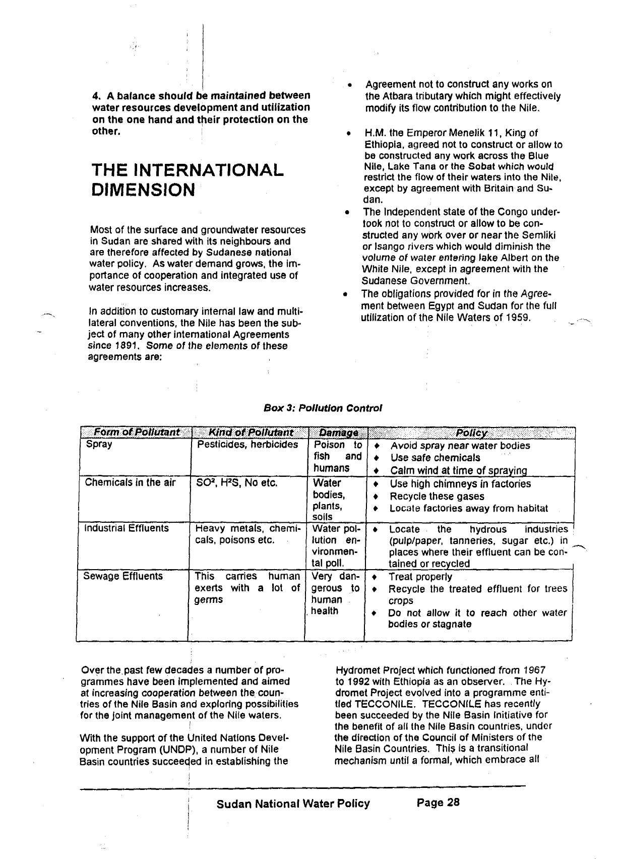
4, A balance should be maintained between
water resources development and utilization
on the one hand and their protection on the
other. i
THE INTERNATIONAL
DIMENSION
Most of the surface and groundwater resources
in Sudan are shared with its neighbours and
are therefore affected by Sudanese national
water policy. As water demand grows, the im-
portance of cooperation and integrated use of
water resources increases.
In addition to customary internal law and multi-
lateral conventions, the Nile has been the sub-
ject of many other international Agreements
since 1891. Some of the elements of these
agreements are:
Agreement not to construct any works on
the Atbara tributary which might effectively
modify its flow contribution to the Nile.
H.M. the Emperor Menelik
11,
King of
Ethiopia, agreed not to construct or allow to
be constructed any work across the Blue
Nile,
Lake Tana or the Sobat which would
restrict the flow of their waters into the Nile,
except by agreement with Britain and Su-
dan.
The Independent state of the Congo under-
took not to construct or allow to be con-
structed any work over or near the Semliki
or Isango rivers which would diminish the
volume of water entering lake Albert on the
White Nile, except in agreement with the
Sudanese Government.
The obligations provided for in the Agree-
ment between Egypt and Sudan for the full
utilization of the Nile Waters of 1959.
Box
3:
Pollution Control
m^MmiitfB^lititant^
Spray
Chemicals in the air
Industrial Effluents
Sewage Effluents
m^mmmmtmnmi
Pesticides, herbicides
SO
3
.
H
2
S, No etc.
Heavy metals, chemi-
cals,
poisons etc.
This carries human
exerts with a lot of
germs
Damiagm
Poison to
fish and
humans
Water
bodies,
plants,
soils
Water pol-
lution en-
vironmen-
tal
poll.
Very dan-
gerous to
human
health
• Avoid spray near water bodies
• Use safe chemicals
• Calm wind at time of spraying
• Use high chimneys in factories
• Recycle these gases
• Locate factories away from habitat
• Locate the hydrous industries
(pulp/paper, tanneries, sugar etc.) in
places where their effluent can be con-
tained or recycled
• Treat properly
• Recycle the treated effluent for trees
crops
• Do not allow it to reach other water
bodies or stagnate
Over
the,
past few decades a number of pro-
grammes have been implemented and aimed
at increasing cooperation between the coun-
tries of the Nile Basin and exploring possibilities
for the joint management of the Nile waters.
With the support of the United Nations Devel-
opment Program (UNDP), a number of Nile
Basin countries succeeded in establishing the
Hydromet Project which functioned from 1967
to 1992 with Ethiopia as an observer. The Hy-
dromet Project evolved into a programme
enti-
tled TECCONILE. TECCONILE has recently
been succeeded by the Nile Basin Initiative for
the benefit of all the Nile Basin countries, under
the direction of the Council of Ministers of the
Nile Basin Countries. This is a transitional
mechanism until a formal, which embrace all
Sudan National Water Policy
Page 28
basin-wide cooperative framework is devel-
oped.
The Permanent Joint Technical Commit-
tee (PJTC) of the Nile between Sudan and
Egypt evolved from the 1959 Nile Agreement. It
has been functioning well since then under all
political regemes. ESTAC, a joint Advisory
Committee of the Nile Water between Sudan
and Ethiopia was formed in 1993. Such sub-
basin activities are expected to continue.
A dam has recently been built on Wadi Hawar
between Sudan and Chad on the basis of
shared costs and benefits. Efforts are under-
way to assess and manage the Nubian sand-
stone aquifer between Chad, Egypt, Libya and
Sudan.
Cooperation and coordination between
countries sharing the same water resource
should be encouraged. Sudan will continue to
maintain its leading role in advancing coopera-
tion for the benefit of all.
Since water does not recognize political
boundaries whether national or international,
management of water resources are best car-
ried out on a regional or catchment-wide basis.
Such areas generally coincide either with
natu-
ral areas with linked supply systems or with
areas sharing common socio-economic inter-
ests.
Conflicting interests inevitably result in
the need for national management and super-
vision,
however. The principle of subsidiarity
should not conflict with the need for a national
and international perspective on water use.
Policy principles and objectives
1.
Sudan will seek to co-operate with other
countries for the development, optimum use
and protection of international waters wher-
ever possible in its national interest and
without compromising its sovereignty.
2.
Watershed management inside the coun-
try and in neighbouring countries is a pre-
requisite for efficient water use and for
strengthening political relations;
DISASTER
MANAGEMENT AND
PUBLIC SAFETY
Natural disaster management
Disaster Management in relation to water policy
pertains to floods and droughts which threaten
the safety of the public. Public safety'includes
the safety of infrastructure, particularly the
safety of dams and reservoirs.
Ensuring that flood prone areas are not inhab-
ited can mitigate the effects of floods. The
population has to be warned to build their
houses and property at the minimum safe dis-
tance from the highest flood level which is de-
markated by the authorities. The 1988,1994
and 1998 floods can be taken as a reference,
A minimum distance in level should be left be-
tween the flood level and the first line of
houses. Similarly, standards are required for
the specification of drainage systems such as
the number and size of culverts and water con-
duits which can accommodate flooding caused
by maximum expected rainfall events.
In order to mitigate the effects of drought, the
objective of water policy should be to meet op-
timum water requirements for each locality and
to develop water storage facilities to meet de-
mands in times of crisis. Water budgets should
be established in each locality to provide infor-
mation on minimum water needs. Traditional
methodologies for coping with drought condi-
tions should be encouraged. Other strategies
should also be employed such as the use of
drought resistant crop varieties.
Disaster management should include such fac-
tors as procedures for information collection
and analysis, monitoring of resources and early
warning systems. These would clearly be dif-
ferent for flood and drought disasters.
Policy principles and objectives
1.
A national Disaster Management Plan will
be developed to enable both of the avoid-
ance of disasters and affective response to
disasters,
2.
International co-operation is critical for
proper and adequate response to natural
and other disasters. Sudan will seek to par-
ticipate in and contribute to international
efforts such as the Program to Combat De-
sertification.
Sudan National Water Policy
Page 29

Publicsafety
There are a number of aspects related to water
resources management which may constitute a
threat to public safety such as large hydrologi-
cal structures, dams etc. Because of the size
of these structures and the disastrous conse-
quences should they
fail,
it is important to en-
sure that adequate steps are taken to ensure
that they are safe.. ;
Public safety implies a cost. A dam could be
built with excessive factors of safety which
would ensure that the probability of failure un-
der any circumstances Is extremely low but this
would be very expensive. The objective is to
establish a safety management regime which
will ensure that a balance is maintained be-
tween safety and cost.
The management of public safety must include
all factors relating to the safety of structures,
design codes for structures which have a safety
risk, inspection procedures during construction
and operation,
operating
1
and
maintenance
rules,
procedures for information collection and
analysis, and early warning systems. Contin-
gency plans should also be drawn up for public
notification, evacuation etc.
Policy principle and objective
1.
In order to ensure adequate public pro*
tection,
regulatory and administrative in-
struments which balance the cost of safety
measures with an acceptable level of risk to
public safety will be developed and imple-
mented at national and federal level as ap-
propriate.
Sudan National Water Policy Page 30
puterization, system analysis, GIS, remote
sensing telemetry and mathematical modeling.
There is a pressing need to strengthen educa-
tional and training capacities in information
management at all levels. Emphasis in training
should be placed on data handling and analysis
and water management monitoring, A special
task force on training under the leadership of
the Water Management and Irrigation Institute
of the University of Gezira is suggested. It will
need to work in close coordination with the Min-
istry of Irrigation and the UNESCO Chair for •'
Waterdesourcef and investigate the modifica-
tions which are necessary in the syllabi and ,
curricula of undergraduate and post-graduate
courses. There is also an urgent need to pro-
mote coordination between the different na-
tional agencies through the forum of the Na-
tional Council for Water Resources.
Research
There is a need for structured research on the
impact of water policy. Research is needed to,
enter alia, analyze the effects of water alloca-
tion on equity and efficiency. National re-
search institutions need to develop and apply
methodologies for assessing users' perceptions
towards water allocation, integrated land and
water resources uses, the use of modeling
tools and procedures for stake-holders en-
volvement.
Capacity building
Building the capacity of the water sector at „
large in the country is one of the fundamental
requirements for achieving proper water re- *
sources management. This is a very large un-
dertaking,
however. ; '
By adopting a modular approach to larger ca-
pacity building programmes, training events
can be planned with application In the work en-
vironment. This method will allow the integra-
tion of theory and practice and encourage par-
ticipants to discuss and review their experi-
ences. The end result is a more sustainable
improvement in water assessment and man-
agement techniques.
The modular combinations suggested for adop-
tion at federal and State levels are:
• initiating monitoring programmes for uses
from different water resources;
• improving and expanding analytical and
data management capacities;
• assessing performance of water supply and
sanitation agencies;
• assessing performance of water resources
management agencies. "
There is a need to emphasize the fact that the
types of training offered are to be consistent
with the full range of training possibilities. The
priority areas are:-
v
- the sedimentation problem,
-"water measurement problems/
- irrigation system performance,
- operational efficiency constraints,
• environmental concerns,
- participatory approaches,
- the role and empowerment of women,
- water conservation and quality,
- planning, control and coordination, and
- strategic planning.
For each capacity building intervention, there
has to be a set of measurable objectives.
Wherever possible the targeted groups are to
be consulted before capacity building pro-
grammes are planned. Capacity building
progrmmes are to be targeted at the full range
of skilled personnel, from operation and main-
tenance activities, to design and technician lev-
els,
to the higher
technical,
managerial and pro-
fessional levels.
External assistance
External donor assistance will be needed to
support capacity building programmes, espe-
cially those that focus on users' groups. The
output of such assistance is to encourage the
devolution of responsibilities, tasks and author-
ity to local level users' groups. The kinds of
technical assistance to be extended are to be
directed to developing and evaluating water
databases, agricultural knowledge systems and
methodologies for water development and
evaluation.
A specific capacity building programme for the
water sector is recommended within the context
of Sustainable Human Development as stated
in the Country's Strategy Note drafted jointly by
the government and the UNDP. The pro-
gramme is to be entrusted to a specialized task
force representing the various disciplines of the
water sector. The focal point will be the Minis-
try of Irrigation and Water Resources which will
be responsible for appointing a coordinator.
The Coordinator is the contact member of the
Sudan National Vater Policy
Page 33
task force who will cooperate with training
Insti-
tutions inside and outside the country and be
responsible for arranging funding and agreeing
allocation principles with the Donors, the Minis-
try of Finance and the Focal Point. In addition
to directing the Task Force, the Coordinator will
monitor the progress of the programme and
ensure timely implementation.
The experience of the community-based sys-
tems under the Area Development Schemes
and Area Rehabitation Schemes(ADS/ARS)
approach of the UNDP funded programme in
Sudan are to be used as additional input to the
project. Despite some shortcomings, they pro-
vide effective modalities of participatory capac-
ity building activity. They are ideal as examples
of community water resource management and
self-governance.
Other themes of relevance to capacity building
in the water sector in Sudan are the national
strategies to be drafted in compliance with the
Convention on Biological Diversity (CBD), the
Convention on Climate Changes (UN FCCC)
and the convention to Combat Desertification
(UNCCD). The Action Plan for Sudan will cer-
tainly involve issues aimed at water resources
conservation, managing and monitoring, with
relevant capacity building dimensions.
PART 3: CONCLUSION
CONCLUSION
The establishment of this National Water Policy
for Sudan marks a milestone in the water sec-
tor and in the history of our development as a
nation.
This policy is commended to all the
people of Sudan who use water everyday in
their homes, on their farms, with their cattle and
in their factories.
Water is precious and we have a duty to look
after it in our own Interests and in the interests
of our children. This policy points to many ar-
eas where the use and protection of our water
resources could and should be improved In the
interests of all our people. The Government of
Sudan is committed to implementing the
poli-
cies contained in the document and to taking
action where necessary if our water resources
are abused or threatened.
It should be realized that water scarcity in fu-
ture would result due to the fact that an ex-
panding population is using ever-increasing
quantities of a finite resource. However, the
potential for water saving is enormous If all us-
ers are urged to manage their supplies in order
to ensure that future generations live in a world
of water security not water scarcity.
Policy is never static - it needs to develop and
grow as our economy and our technology
grows. Many people have contributed to the
writing of this policy document and all people in
Sudan are invited to comment on it and con-
tribute to its ongoing development and refine-
ment.
-00O00—
Sudan National Water Policy
Page 34
