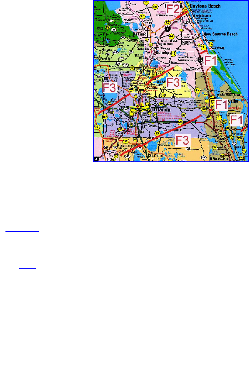
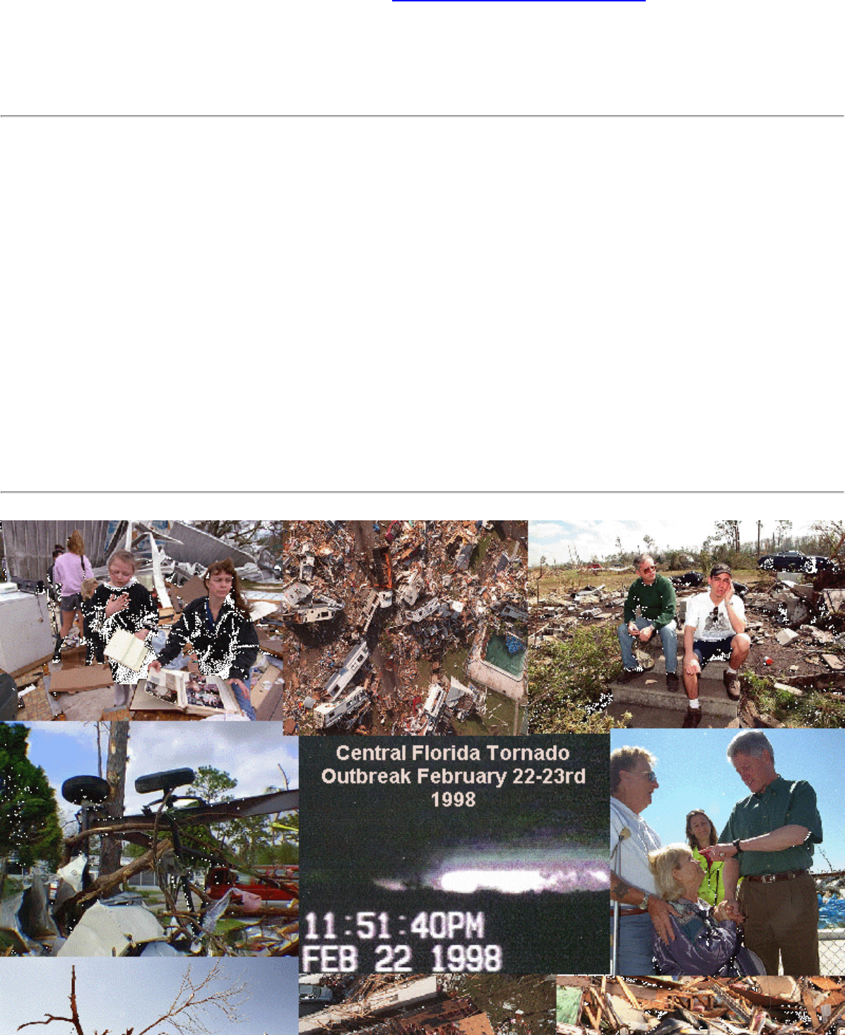
The Central Florida Tornado Outbreak
of 22-23 February, 1998
1997-1998 Southern Region Service Enhancement Project
GOLD MEDAL WINNER
Submitted August 1998
National Weather Service Forecast Office
Melbourne, Florida
Event Synopsis
During the late night and early morning hours of 22-23 February 1998 (Sunday - Monday), the
most
devastating tornado outbreak ever to occur in the state of Florida, in terms of both loss of life
and property
damage, occurred within the county warning area of the Melbourne (MLB) National
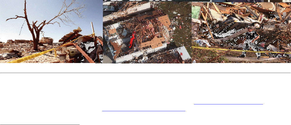
Weather Service Office (NWSO). Forty-two people died as a result of the tornadoes and more than 260
others were injured. Over 3,000 structures were damaged, and more than 700 were completely destroyed.
A total of
seven confirmed tornadoes occurred that night. Four of the tornadoes were unusually long-
lived and produced damage tracks of between 8 and 38 miles, resulting in the majority of damage and
all fatalities. Uncommon among Florida tornadoes, the estimated wind speed for three of these
twisters reached 200 mph which is on the high end of F3 intensity on the
Fujita scale. Although this
event was of historical proportion the number of fatalities could have been significantly higher if these
killer tornadoes were not accurately forecast, detected, and then warned for in a timely and
professional manner.
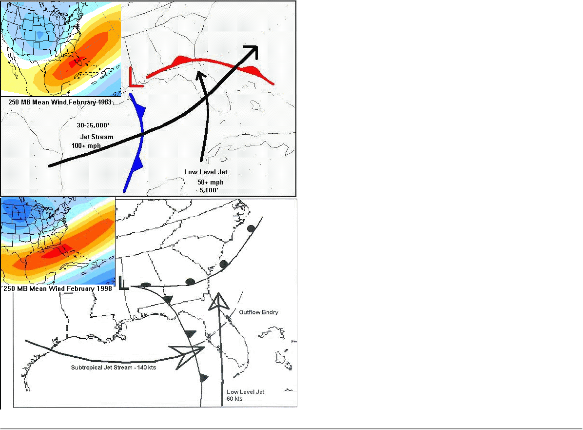
Local applied research conducted by MLB earlier in the year indicated the likelihood of an active
severe weather season across central Florida during the winter and spring of 1997-98. This was a direct
result of the southward relocation of the upper jet stream across the Gulf of Mexico and Florida peninsula
due to large scale effects from El Nino. From the research a conceptual model was created depicting
the
idealized synoptic setting for peninsular Florida tornado outbreaks during strong El Nino years. Based
on these expectations, MLB alerted its citizens as early as October regarding the chances for a greater
number of severe weather episodes with stronger than normal tornadoes. This information was featured
1
http://www.srh.weather.gov/mlb/research.html

on MLB's Internet home page and was also presented to the division of Florida Emergency Managers
(EMs) at the state-sponsored "Florida El Nino Summit" in mid-December of 1997. In preparation,
specific forecaster training was conducted at MLB concentrating on the anticipation and detection of strong
& violent tornadoes.
The increasing likelihood for tornadoes on 22-23 February was apparent to MLB forecasters as early as
20 February (Friday afternoon).
Atmospheric conditions were coming together to approximate the
conceptual model. Prior to the event, the suite of products issued by MLB, including two
coordinated statewide statements issued by NWSO Miami (
1 and 2) alerted local media,
emergency management, rescue & law enforcement, and the public of east central Florida to the threat
of significant severe weather more than 48 hours in advance. Hazardous Weather Outlooks (HWO),
designed to assist civil support agencies for emergency preparedness and planning, were issued twice
daily beginning Saturday afternoon which refined the timing, specifics, and seriousness of the
impending severe weather threat. In the HWO issued
525 AM Sunday, the continuing threat for
tornadoes was restated. It was also mentioned that the storm movement would be rapidly east-northeast at
40 to 50 MPH and people should "seek shelter well in advance of approaching storms". Later, an
updated HWO
(1155 AM) highlighted areas in proximity of a line from Tampa Bay to Cape Canaveral as
the region most prone to severe weather. After coordination with MLB, the Storm Prediction Center issued
a tornado watch for much of the peninsula from 9 PM through 3 AM (Monday) due to developing
strong convection over the extreme eastern Gulf of Mexico. With a growing squall line of
thunderstorms heading toward central Florida, the operations team was now fully postured for severe
weather, shifting the emphasis to the issuance of timely and accurate "short-fuse" weather products.
As the event began to unfold, a Short Term Forecast (NOW) was issued at 909 PM headlining the
initial "Threat for severe storms increasing for Lake and Volusia Counties". The
939 PM NOW stated
that tornadoes were possible over northwestern Lake County between 950 PM and 1010 PM, and
that residents should be prepared for imminent warnings. These detailed forecasts preceded the first
Tornado Warning (TOR) for Lake County which was issued at
945 PM based on Doppler radar signatures.
A telephone coordination call was placed to the Lake County EM to inform them of the warning and to
list various towns in the path of the storm. Personally informing the each county would become a
critical standard procedure for all subsequent warnings throughout the outbreak.
A Severe Weather Statement (SVS) was then issued at 1010 PM to update information concerning the
Lake County warning and also recommended that residents of Volusia County prepare for the possibility
of tornadoes. It was decided that SVS products would be tone-alerted on the NOAA Weather Radio in
the same way that actual warnings (TORs) are tone-alerted. This is not routine practice but since the
storms were moving so rapidly vital information contained within the warnings required frequent
updating. Several phone calls were made to the Volusia County Sheriff dispatcher between 1030 and 11 PM
to update the location of the tornadic storm and the communities in it's path. The first tornado of the
evening touched down at 1055 PM and produced damage until reaching the coast at 1105 PM. Real-
time storm spotter observations of a lowering funnel cloud were called into MLB from ham radio
operators. Soon after, reports from the Sheriff's office indicated four tractor-trailers had been rolled over
on Interstate 4, just west of Daytona Beach. The official storm survey would later show extensive
destruction, including one fatality which occurred when a mobile home was destroyed. Concerned that
a major outbreak of multiple tornadoes would occur late into the night, a special-edition HWO was issued
at
1040 PM. The main intent was to signal local television newscasters before the evening (11 PM) news
so that as many people as possible would be informed before going to sleep for the night. Other
significant text included the declaration "...this is a dangerous situation!".
At 1127 PM, a second TOR was issued for Lake County as suspicious circular rotation was detected
2
http://www.srh.weather.gov/mlb/research.html

by DOPPLER radar within two separate thunderstorms over the county. This warning was quickly
followed by a TOR for adjacent western Orange County at
1137 PM as the southern storm intensified and
was approaching the county line near the city of Winter Garden. A supporting SVS
(1146 PM) listed the
cities in immediate path of the approaching tornadic storm, and also alerted residents in the next
county downstream (Seminole) of the imminent TOR for their county. At 1150 PM, an amateur
radio operator reported a
"tornado on the ground" in Winter Garden. This information was
disseminated immediately in a concise
SVS which notified Ocoee and Apopka residents to take cover at
once. A TOR was issued for Seminole County at
1156 PM, which included the report from Winter Garden
in order to invoke swift public reaction. Once again, several calls were made to Seminole County to
inform EM personnel of the danger. A NOW at
1205 AM updated the east central Florida short term
weather picture, followed by an SVS at
1211 AM which summarized the coincident warnings in effect
while urging Lake Mary and Sanford residents to "...act now to protect their lives!". Soon after,
numerous reports of significant damage from Orange and Seminole counties were relayed to MLB
via amateur radio and Skywarn spotters, television news, and county EM's. By morning it would
be concluded that three people would die from the Winter Garden tornado and another thirteen would
be killed from the Sanford tornado.
Even with several warnings in effect, more warnings were quick to follow: a third TOR (1214 AM)
for Volusia county was followed by a TOR for Osceola County at
1222 AM. The most devastating
killer tornado of the event touched down in Osceola County at 1240 AM just southwest of Kissimmee.
This area is known to have a high population of tourists as well as numerous RV parks. The
Kissimmee tornado was preceded by the 1222 AM TOR and the
1237 AM SVS both placing the town
directly in the tornado's path. The Doppler radar depiction of the tornadic thunderstorm is seen
here.
More people were killed from this single tornado (25) than were killed in any previous Florida
outbreak. Many were killed in the
Ponderosa RV Park.
Continuing throughout the remainder of the morning, numerous reports of damage and casualties
from tornado touchdowns were called into the NWS office from each impacted county. The information
was placed in subsequent TORs which were issued for Orange (
1240 AM, 119 AM), Osceola (119 AM,
304 AM) and Brevard Counties (123 AM, 227 AM, and 316 AM) for other tornadic storms which went on
to produce considerable damage in unpopulated rural areas. However, notable structural damage was
reported southwest of Edgewater, near Titusville, and at Port Canaveral.
Throughout the event, the operations team issued accurate, timely short-fuse weather products in a
rapidly evolving situation, with tornadic storms moving as fast as 50 to 60 MPH at times. All seven
tornadoes were preceded by Tornado Warnings (TOR) with
positive lead times. Statistically, the
official assessment team found MLB's performance to be "excellent" (pdf version). The Probability
of Detection (POD) was found to be an impressive 100 percent while the False Alarm Ratio (FAR) was
only 31 percent. Lead times before fatalities in each of the four counties which experienced killer
tornadoes was 23 minutes while the average lead time for all tornadoes in all counties was 15 minutes.
Both of these statistics are well-above the national average. Between 830 PM Sunday evening and 420
AM Monday morning, a total of
52 event-related short-fuse weather products were issued, an average of
about one product every nine minutes over an eight hour period, including TORs,
FFWs, SVSs,
NOWs, Special Marine Warnings
(SMW) Flood Statements (FFS), Local Airport Advisories (LAA)
and Local Storm Reports (LSR). Of unique interest was the
1045 PM Local Airport Advisory for the
Daytona Beach International Airport (DAB) which stressed that a severe storm with a possible tornado
would pass very near the airport facility.
A final commentary worthy of documentation was that during the event MLB was engaged in a
3
http://www.srh.weather.gov/mlb/research.html
selective testing of an experimental workstation called the Warning Decision Support System (WDSS).
This system was developed by the National Severe Storms Laboratory (NSSL) and was running the
latest severe storm detection algorithms to include a new
Tornado Detection Algorithm (TDA). While
using experimental output during actual situations can cloud a forecaster's warning decision process,
the WDSS performed remarkably well and added value to warning operations. In part, experiences from
this event have increased confidence in the TDA's performance which will soon be ported over to
the operational system in late 1998.
ZCZC MIAPNSMLB
TTAA00 KMLB 231105
PUBLIC INFORMATION STATEMENT
NATIONAL WEATHER SERVICE MELBOURNE FL
600 AM EST MON FEB 23 1998
...EAST CENTRAL FLORIDA TORNADO OUTBREAK POSSIBLY THE MOST DEVASTATING IN THE HISTORY
OF FLORIDA...
PRELIMINARY REPORTS OF OVER 20 FATALITIES OBTAINED FROM NEWS REPORTS IN THE AFTERMATH OF
THE TORNADO OUTBREAK THAT STRUCK EAST CENTRAL FLORIDA LATE SUNDAY NIGHT AND EARLY
THIS MORNING INDICATE IT MAY BE THE DEADLIEST IN FLORIDA HISTORY. THE ONLY
COMPARABLE OUTBREAKS ARE THE TORNADO OUTBREAK OF MARCH 31ST 1962 THAT KILLED 17 PEOPLE
IN SANTA ROSA COUNTY AND THE TORNADO OUTBREAK OF APRIL 4TH 1966 THAT KILLED 11 PEOPLE
IN HILLSBOROUGH AND POLK COUNTIES.
HAGEMEYER
4
http://www.srh.weather.gov/mlb/research.html
The 22-23 February 1998 East-Central Florida Tornado Outbreak
Chronology of Events
(Note: For brevity, only events relating to the tornadic episode are listed;
see table at the bottom of the
chronology for a list of the tornadoes.)
Sunday, February 22, 1998
200-230 AM - Forecast coordination calls were made to NWSO Tampa Bay and NWSFO Miami regarding
the timing/possibility of severe weather.
525 AM - A HWO was issued which continued to mention the threats for damaging wind gusts over 55 mph,
large hail and tornadoes. The HWO also mentioned that storms would be moving at up to 50 mph and that
people would need to "SEEK SHELTER WELL IN ADVANCE OF APPROACHING STORMS".
Morning - The day shift forecaster coordinated with the MIC as well as evening shift personnel concerning
the need for additional staffing for the afternoon/evening hours. He also contacted all SKYWARN net
coordinators across the northern half of CWA regarding potential activation.
1155 AM - A HWO was issued which headlined "SIGNIFICANT THREAT OF DAMAGING WINDS...HAIL...
AND TORNADOES THIS AFTERNOON AND EVENING".
1230 PM - MIC arrived on station to work a less significant afternoon severe weather event.
200 PM - The evening shift forecaster arrived early to work afternoon severe weather event. Amateur
radio operator arrived on station to work both afternoon/evening events.
Mid to Late Afternoon - The Science and Operations Office (SOO) stopped into the office on three
separate occasions to check on the status of personnel/operations. Other actions taken by the staff during this
time period were related to the afternoon severe weather event.
610 PM - The evening shift forecaster phoned the Storm Prediction Center (SPC) to emphasize the need to
extend the tornado watch into early Monday morning.
813 PM - The Tornado Watch was re-issued by SPC for central Florida until 300 AM Monday.
908 PM - The Brevard county EM director telephoned and was briefed by the Severe Weather Coordinator
(SWC) regarding the potential for severe weather the remainder of the night.
909 PM - A Short Term Forecast (NOW) headlined "THREAT FOR STRONG STORMS INCREASING FOR LAKE
AND VOLUSIA COUNTIES", and also mentioned conditions were favorable for tornadoes to develop.
935 PM - The MLB radar operator phoned NWS Jacksonville regarding possible tornadic cells moving into
their county warning area (CWA).
939 PM - A NOW was issued for Lake County which headlined the threat for "ISOLATED
TORNADOES INCREASING" and alerted residents to prepare for a possible warning.
5
http://www.srh.weather.gov/mlb/research.html
941 PM - The SWC briefed the Skywarn coordinator in Lady Lake that a tornado was possible in that
area beginning between 955 and 1000 PM.
945 PM - A Tornado Warning (TOR) was issued for Lake County. Lake Griffin, Lady Lake and Emerald were
listed as being in the path of the possible tornado.
958 PM - A Severe Weather Statement (SVS) was issued for Lake County mentioning possible
tornado touchdowns from west of Leesburg to Fruitland Park, Lady Lake, and Lake Griffin.
1000 PM - Lake County SKYWARN reported dime-sized hail to the amateur radio operator at NWS Melbourne.
1010 PM - A SVS was issued for Lake and Volusia Counties. Altoona...Paisley and Astor Park are listed in the
path of the possible tornado. The SVS mentions the hail report from Altoona. Residents of Volusia County
were advised to prepare for a Tornado Warning.
1011 PM - NWS Jacksonville advise the Melbourne radar operator that their radar indicated a tornadic
vortex signature (TVS) approaching Altoona.
1016 PM - The SWC briefed Lake County SKYWARN about a possible tornado near Altoona, moving
towards Pittman and Astor Park.
1022 PM - A TOR was issued for Volusia County, mentioning that the storm with a possible tornado will move
into Volusia County near Pierson and Barberville.
1028 PM - A NOW was issued, mentioning severe thunderstorms with possible tornadoes from Leesburg
to Daytona Beach, with more tornadic storms possible as far south as Sanford and Orlando. Residents of
Seminole and Orange Counties were urged to "TAKE QUICK ACTION WHEN WARNINGS ARE ISSUED".
1033-1040 PM - The SWC called the Volusia County Sheriff's dispatcher to continuously update the location of
a possible tornado. These updates were relayed immediately to deputies on patrol in the area.
1040 PM - Prior to the local late night news, a special HWO was issued to alert the general public, the
central Florida EM offices, and the Orlando TV network affiliates to the continuing tornadic threat. It
emphatically stated: "ANOTHER ROUND OF SEVERE WEATHER IS EXPECTED!", and urged local law
enforcement and EM personnel to coordinate with the NWS in Melbourne.
1041 PM - A SVS was issued for Lake and Volusia Counties, mentioning potential for tornado touchdowns
from DeLeon Springs to Glenwood, and along U.S. 17, U.S. 92, and State Road 11. Tornadic storms were
forecast to reach the coast between 11:00 and 11:15 PM.
1045 PM - A Local Airport Advisory (LAA) was issued for Daytona Beach International Airport (DAB) for wind
gusts above 35 knots, excessive lightning and hail at least 1/2 inch in diameter. Airport operations was alerted
by phone of the possibility of a tornadic storm passing very close to the airfield.
1049 PM - A Special Marine Warning (SMW) was issued for intracoastal/nearshore Atlantic waters between
Flagler Beach and Mosquito Lagoon for tornadic storms moving offshore.
1053 PM - Volusia County SKYWARN reported high winds blew trees down, and forced cars off the road on U.
S. 17 north of Deland at 1045 PM.
1055 PM - A delayed report of a funnel cloud near Eustis in Lake County at 1010 PM was received from WESH-TV.
1057 PM - The SWC briefed the Volusia County Sheriff's office concerning the strong tornadic
signature approaching Holly Hill and Ormond Beach.
1059 - A SVS was issued for Lake and Volusia Counties, mentioning a possible tornado moving towards
Daytona Beach, Holly Hill and Ormond Beach. The earlier wind damage report was also mentioned.
6
http://www.srh.weather.gov/mlb/research.html

1105 PM - A Ham radio operator reported strong winds in South Daytona area - estimated 50 MPH.
1107 PM - A Ham radio operator 2 miles north of Port Orange reported a funnel cloud sighting.
1108 PM - Daytona Beach Police Department reported a tornado touchdown with injuries in the south part
of Daytona Beach around 1105 PM.
1108 PM - A SVS was immediately issued relaying the tornado touchdown report, and alerting residents on
the barrier islands to the east to: "TAKE SHELTER NOW!!! A TORNADO TOUCHDOWN MAY BE IMMINENT!!!"
1110 PM - Volusia County SKYWARN reported that 4 tractor-trailers were rolled over by tornadic winds at the I-
95/I-4 interchange. Also, many homes and apartments in the Holly Hill/ South Daytona area had suffered
damage. One serious injury was also reported.
1120 PM - The TOR for Volusia County was extended due to the line of severe and potentially tornadic storms
still extending from near Daytona Beach to DeLand.
1127 PM - A TOR was issued for Lake County due to possible tornadoes indicated by radar near Leesburg
and southwest of Clermont.
1130 PM - A delayed report came in from the Daytona Beach Airport Air Traffic Control Tower (ATCT) of a
wind gust of 77 MPH.
1137 PM - A TOR was issued for western Orange County for a possible tornado near Clermont in Lake
County moving toward Winter Garden, Lake Apopka and Ocoee.
1146 PM - A SVS issued for Volusia/Lake/Orange/Seminole/Osceola Counties mentioned possible
tornadoes approaching DeLand, Winter Garden, Ocoee and Apopka. Residents of Seminole County were told
to prepare for a warning as a tornadic storm was eventually headed for Altamonte Springs and Longwood.
1148 PM - A Local Storm Report (LSR) was sent out, listing the severe weather and tornado damage
reports gathered from Volusia County.
1150 PM - An amateur radio operator in Seminole County reported a tornado on the ground in Winter
Garden, moving toward Apopka.
1151 PM - A SVS issued for Orange County headlined: "TORNADO ON THE GROUND IN WINTER GARDEN".
1155 PM - A ham radio operator ralyed a report from the Ocoee Police of a funnel cloud sighting over Ocoee.
1156 PM - A TOR was issued for Seminole County for a tornadic storm near Apopka, expected to be
near Altamonte Springs, Longwood and Lake Mary. The storm was mentioned as having produced a tornado
in Winter Garden.
1156 PM - The SWC called Seminole County EM to brief them about the possible tornado approaching
the Altamonte Springs/Longwood area.
Monday, February 23, 1998
Midnight - The SWC called the Volusia County Sheriff to alert him of the potential for a tornado touchdown in
the area from Osteen to Edgewater.
1202 AM - A Ham radio operator reported that the Circle-K in Winter Garden was hit by a tornado, and that
there were injuries.
1205 AM - The SWC briefed Seminole EM about a possible tornado headed for Lake Mary and Sanford/Midway.
7
http://www.srh.weather.gov/mlb/research.html
1205 AM - A NOW outlined the area from Kissimmee and Orlando north to Leesburg and Sanford and east
to Daytona Beach and Flagler Beach as being prone to tornado touchdowns.
1211 AM - A SVS was issued for Volusia/Lake/Orange/Seminole/Osceola Counties, and listed Lake Mary
and Sanford as being the path of a tornado.The tornadic damage reports from Orange County were mentioned.
1214 AM - Another TOR for Volusia County outlined the area from Deltona to Osteen and Lake Ashby for
potential tornado touchdowns.
1215 AM - A Ham radio operator in Lake Mary (Seminole County) reported strong winds and small hail at
the intersection of I-4 and Lake Mary Boulevard.
1217 AM - The SWC briefed Osceola County EM about the potential for tornadoes near the Kissimmee
attractions area.
1222 AM - The SWC briefed Volusia County EM concerning possible tornado touchdowns from Osteen
to Edgewater.
1222 AM - A TOR was issued for Osceola County, which listed Intercession City and Kissimmee as being in
the path of a possible tornado. Residents in southwest Orange County were advised to prepare for an extension
of the tornado warning as it this tornado was forecast to move into their area.
1229 AM - A LAA was issued for Orlando International and Executive Airports (MCO/ORL), since the
tornadic Kissimmee storm was headed towards the airfield.
1235 AM - A SKYWARN spotter in Kissimmee sighted a possible funnel cloud to the southwest of his location.
1237 AM - A SVS issued for Volusia/Lake/Seminole/Orange/Osceola Counties mentioning tornadoes
were indicated by radar near Osteen, Ocoee, Maitland and Kissimmee. The SVS also mentioned that the
Orange County TOR would be extended.
1238 AM - A Ham radio operator reported sighting a funnel cloud over U.S. 17/92 in Campbell City.
1240 AM - The TOR was extended for Orange County due to Kissimmee tornado moving towards the
MCO Airport.
1249 AM - A Ham radio operator relayed a report of a tornado touching down in Kissimmee with one home
having it's roof removed.
1249 AM - SKYWARN spotter (see 1235 AM) estimated winds of 70 MPH at his location.
1250 AM - Orange County EM reported multiple tornado touchdowns around Winter Garden.
1250 AM - A SKYWARN spotter on Boggy Creek Road in northeast Kissimmee reported seeing a funnel
cloud illuminated by continuous lightning.
1253 AM - A SVS for Volusia/Lake/Seminole/Orange/Osceola/Brevard Counties highlighted tornadoes
near Edgewater, Sanford, Kissimmee and Orlando. It also mentioned possible tornadoes farther east into
Brevard County near Titusville through 3 AM.
1257 AM - Seminole County EM reported numerous tornado touchdowns in Longwood, Sanford, Winter
Springs and Geneva.
105 AM - The first news reports of a fatality are received from Volusia County as a man was killed when
his mobile home was destroyed.
105 AM - A delayed report of hail of unknown size was received from a SKYWARN spotter (see 1235, 1249 AM).
106 AM - A Ham radio operator reported a funnel cloud west of Orlando over the Beeline Expressway.
8
http://www.srh.weather.gov/mlb/research.html
108 AM - A SVS was issued or Volusia/Seminole/Orange/Osceola/Brevard Counties for torndoes indicated by
radar east of Orlando, and near Edgewater, Lake Harney, Lake Toho. The SVS also highlighted significant
damage in Seminole County, and alerted Brevard County residents that a warning would likely be issued soon.
110 AM - The SWC briefed the SPC lead forecaster on the damage/injuries confirmed thus far.
117 AM - A NOW was issued to emphasize the tornadic threat area shifting southeast towards Brevard County.
119 AM - TORs for Orange and Osceola counties were extended due to lingering tornadic cells in eastern part
of both counties. The warning emphasized: "TORNADOES HAVE ALREADY CLAIMED A LIFE IN VOLUSIA
COUNTY! TAKE SHELTER NOW!!!"
121 AM - The SWC informed the Cape Canaveral Air Force Station (CCAFS) duty forecaster that a TOR was in
the process of being issued for Brevard County.
123 AM - A TOR was issued for Brevard County for possible tornadic storms along and north of a line
from Titusville to Cape Canaveral.
130 - 200 AM - Mutiple news and EM reports of significant, widespread tornadic damage, injuries, and
road closures and were received at the office. Most noteworthy were the reports of near complete destruction of
an apartment complex and a mobile home park in Winter Garden, and of homes, strip malls and a shopping
center being "flattened" by a tornado which tracked from Campbell City to Kissimmee and Narcoosee. The
Florida Turnpike near Kissimmee was closed due to debris. Injuries, some serious, were reported to be in
the dozens.
134 AM - A SVS highlighted a tornado moving towards Titusville in Brevard County.
145 AM - Strong winds and power outages were reported in Port St. John, near Titusville in Brevard County.
150 AM - A SVS for Orange/Osceola/Brevard Counties listed possible tornadoes near Titusville, west of Cocoa,
and southeast of St. Cloud.
218 PM - EM reported a confirmed fatality in Winter Garden.
222 AM - Brevard County Sheriff's dispatcher reported a waterspout over the Indian River near State Road 520.
225 AM - A SVS for Orange/Osceola/Brevard Counties highlighted a tornadic storm near Merritt Island and
that the Brevard County TOR would be extended.
227 AM - A TOR for Brevard County mentioned that Merritt Island and Cape Canaveral were in the path of
a tornadic storm.
230 AM - News reports confirmed 4 fatalities in an RV park in Kissimmee.
245 AM - The SWC coordinated with SPC on letting the Tornado Watch expire, since the threat for tornadoes
was expected to decrease by 4 AM.
246 AM - A SVS for Brevard County alerted south Brevard County to the threat of tornadoes.
It also relayed the report of 6 confirmed fatalities due to tornadoes.
253 AM - The SMW was extended south to Melbourne Beach due to continuing tornadic storms moving offshore.
304 AM - Another TOR was issued for Osceola County due to a developing circulation near Lake Kissimmee.
313 AM - A SVS advised residents of Deer Park in northeast Osceola County to seek shelter due to a
tornadic storm headed in their direction.
316 AM - The TOR for Brevard County was extended due the storm near Deer Park moving towards
9
http://www.srh.weather.gov/mlb/research.html
rapidly northeast towards the county line.
345 AM - Brevard EM reported tornadic wind damage to trees, power lines and homes in Titusville and
Merritt Island. In Port Canaveral, numerous boats were overturned at a marina, and many restaurants adjacent
to the marina suffered major roof damage.
401 AM - A SVS relayed the damage reports from Brevard EM.
419 AM - A SVS reported all watches and warnings were now expired.
600 AM - A Public Information Statement declared this tornadic outbreak to be "POSSIBLY THE
MOST DEVASTATING IN THE HISTORY OF FLORIDA" with over 20 fatalities.
620 AM - A LSR was issued with an updated figure of 27 fatalities from 4 tornadoes.
Summary of Tornadoes
County Warning Issued Began/Entered County First Fatality Ended/Exited County
Volusia (1) 1022 PM 1055 PM 1058 PM 1105 PM
Lake 1127 PM 1137 PM none 1141 PM
Orange 1137 PM 1141 PM 1150 PM 1200 midnight
Seminole (2) 1156 PM 1210 AM 1215 AM 1225 AM
Volusia 1214 AM 1245 AM none 1250 AM
Osceola 1222 AM 1240 AM 12:50 AM 1255 AM
Orange (3) 1240 AM 1255 AM none 128 AM
Brevard (4) 123 AM 138 AM none 140 AM
Brevard (5) 227 AM 230 AM none 233 AM
Note: A SVS was issued for each of the counties denoted by (1) through (5) to give advance notice that a
Tornado Warning was either about to be issued (I) or extended (E) as follows:
(1) 1010 PM - I (2) 1146 PM - I (3) 1237 AM - E (4) 108 AM - I (5) 225 AM - E
FUJITA TORNADO DAMAGE SCALE
F0 SLIGHT DAMAGE LESS THAN 73 MPH
F1 MODERATE DAMAGE 73-112 MPH
F2 CONSIDERABLE DAMAGE 113-157 MPH
F3 SEVERE DESTRUCTION 158-206 MPH
F4 COMPLETE DESTRUCTION 207-260 MPH
F5 COMPLETE DESTRUCTION GREATER THAN 260 MPH
10
http://www.srh.weather.gov/mlb/research.html
ZCZC MIASPSMIA
TTAA00 KMIA 201937
AMZ335-354-374-435-450-452-454-470-472-474-50-555-570-575-610-630-
631-650>654-656-670>676-FLZ016>078-GMZ755-775-830-850-853-856-870-
873-876-221800-
SPECIAL WEATHER STATEMENT
NATIONAL WEATHER SERVICE MIAMI FL
233 PM EST FRI FEB 20 1998
...ANOTHER STRONG WEATHER SYSTEM TO AFFECT FLORIDA AND MARINERS
LATE THIS WEEKEND...
THIS STATEMENT APPLIES TO ALL OF FLORIDA.
SATURDAY SHOULD BE A FAIRLY NICE DAY ACROSS THE SUNSHINE STATE.
HOWEVER... CURRENT COMPUTER MODELS INDICATE ANOTHER STRONG
WEATHER SYSTEM WILL DEVELOP OVER THE GULF AND MOVE
TOWARDS FLORIDA LATE SUNDAY.
PRESENT INDICATIONS ARE THIS SYSTEM WILL NOT BE AS STRONG AS THE
STORMS THAT AFFECTED FLORIDA ON GROUNDHOG DAY AND VALENTINE'S DAY.
11
http://www.srh.weather.gov/mlb/research.html

THE GREATEST THREAT WILL BE TO MARINERS IN THE GULF OF MEXICO THIS
WEEKEND AS GALE FORCE WINDS FROM THE EAST AND SOUTH DEVELOP.
THE THREAT OF COASTAL FLOODING APPEARS TO BE MINIMAL FOR THE GULF
COASTAL COUNTIES OF FLORIDA. HOWEVER... MARINERS OPERATING IN THE
ATLANTIC COASTAL WATERS AND FLORIDA STRAITS WILL FIND CONDITIONS
DETERIORATING RAPIDLY ON SUNDAY.
WINDY AND RAINY CONDITIONS ARE EXPECTED STATEWIDE BY SUNDAY NIGHT
AND MONDAY. ANOTHER THREAT THAT THIS WEATHER SYSTEM POSES IS THE
POTENTIAL FOR PROLONGED RAINFALL. THIS COULD AGGRAVATE EXISTING
RIVER FLOODING ACROSS NORTH AND CENTRAL FLORIDA LATE SUNDAY AND MONDAY.
ADDITIONAL STATEMENTS WILL BE ISSUED BY NATIONAL WEATHER SERVICE
OFFICES IN TALAHASSEE... TAMPA BAY... JACKSONVILLE... MELBOURNE...
AND MIAMI THROUGHOUT THE WEEKEND. MEMBERS OF THE EMERGENCY
MANAGEMENT COMMUNITY AND OTHERS WITH OUTDOOR INTERESTS ON
SUNDAY AND MONDAY SHOULD MONITOR WEATHER CONDITIONS CLOSELY
BEGINNING SATURDAY NIGHT.
RB
ZCZC MIASPSMIA
TTAA00 KMIA 201937
AMZ335-354-374-435-450-452-454-470-472-474-50-555-570-575-610-630-
631-650>654-656-670>676-FLZ016>078-GMZ755-775-830-850-853-856-870-
873-876-212300-
SPECIAL WEATHER STATEMENT
NATIONAL WEATHER SERVICE MIAMI FL
545 AM EST SAT FEB 21 1998
...ANOTHER STRONG WEATHER SYSTEM TO AFFECT FLORIDA AND MARINERS
LATE THIS WEEKEND...
THIS STATEMENT APPLIES TO ALL OF FLORIDA.
TODAY SHOULD BE A FAIRLY NICE DAY ACROSS THE SUNSHINE STATE.
HOWEVER... CURRENT WEATHER SERVICE COMPUTER MODELS CONTINUE
TO INDICATE ANOTHER STRONG LOW PRESSURE AREA DEVELOPING OVER THE
WESTERN GULF OF MEXICO TODAY. ONCE THIS LOW PRESSURE AREA FORMS
IT WILL MOVE TOWARD FLORIDA AND IS EXPECTED TO PASS OVER NORTH
FLORIDA LATE SUNDAY.
PRESENT INDICATIONS ARE THIS SYSTEM WILL NOT BE AS STRONG AS THE
STORMS THAT AFFECTED FLORIDA ON GROUNDHOG DAY AND VALENTINE'S
DAY. HOWEVER...THIS SYSTEM WILL BE STRONG ENOUGH TO PRODUCE
THUNDERSTORMS OVER THE STATE. SOME OF THESE THUNDERSTORMS
COULD BE SEVERE WITH THE GREATEST THREAT OF SEVERE THUNDERSTORMS
AND POSSIBLY EVEN TORNADOES OVER THE NORTHERN AND CENTRAL
COUNTIES SUNDAY.
ANOTHER THREAT WILL BE TO MARINERS IN THE GULF OF MEXICO LATE
TONIGHT AND SUNDAY AS WINDS POSSIBLE UP TO GALE FORCE FROM THE
EAST AND SOUTH DEVELOP. THE THREAT OF COASTAL FLOODING APPEARS
TO BE MINIMAL FOR THE GULF COASTAL COUNTIES OF FLORIDA.
MARINERS OPERATING IN THE ATLANTIC COASTAL WATERS AND FLORIDA
12
http://www.srh.weather.gov/mlb/research.html

STRAITS WILL ALSO FIND CONDITIONS DETERIORATING RAPIDLY ON SUNDAY.
WINDY AND RAINY CONDITIONS ARE EXPECTED STATEWIDE BY SUNDAY NIGHT
AND MONDAY. ANOTHER THREAT THAT THIS WEATHER SYSTEM POSES IS THE
POTENTIAL FOR PROLONGED RAINFALL. THIS COULD AGGRAVATE EXISTING
RIVER FLOODING ACROSS NORTH AND CENTRAL FLORIDA SUNDAY AND
MONDAY.
ADDITIONAL STATEMENTS WILL BE ISSUED BY NATIONAL WEATHER SERVICE
OFFICES IN TALAHASSEE...TAMPA BAY...JACKSONVILLE...MELBOURNE...
AND MIAMI THROUGHOUT THE WEEKEND. MEMBERS OF THE EMERGENCY
MANAGEMENT COMMUNITY AND OTHERS WITH OUTDOOR INTERESTS ON
SUNDAY AND MONDAY SHOULD MONITOR WEATHER CONDITIONS CLOSELY
BEGINNING TONIGHT.
ESPOSITO
ZCZC MIASPSMIA
TTAA00 KMIA 201937
AMZ335-354-374-435-450-452-454-470-472-474-50-555-570-575-610-630-
631-650>654-656-670>676-FLZ016>078-GMZ755-775-830-850-853-856-870-
873-876-212300-
SPECIAL WEATHER STATEMENT
NATIONAL WEATHER SERVICE MIAMI FL
545 AM EST SAT FEB 21 1998
...ANOTHER STRONG WEATHER SYSTEM TO AFFECT FLORIDA AND MARINERS
LATE THIS WEEKEND...
THIS STATEMENT APPLIES TO ALL OF FLORIDA.
TODAY SHOULD BE A FAIRLY NICE DAY ACROSS THE SUNSHINE STATE.
HOWEVER... CURRENT WEATHER SERVICE COMPUTER MODELS CONTINUE
TO INDICATE ANOTHER STRONG LOW PRESSURE AREA DEVELOPING OVER
THE WESTERN GULF OF MEXICO TODAY. ONCE THIS LOW PRESSURE AREA
FORMS IT WILL MOVE TOWARD FLORIDA AND IS EXPECTED TO PASS OVER
NORTH FLORIDA LATE SUNDAY.
PRESENT INDICATIONS ARE THIS SYSTEM WILL NOT BE AS STRONG AS THE
STORMS THAT AFFECTED FLORIDA ON GROUNDHOG DAY AND VALENTINE'S
DAY. HOWEVER...THIS SYSTEM WILL BE STRONG ENOUGH TO PRODUCE
THUNDERSTORMS OVER THE STATE. SOME OF THESE THUNDERSTORMS
COULD BE SEVERE WITH THE GREATEST THREAT OF SEVERE THUNDERSTORMS
AND POSSIBLY EVEN TORNADOES OVER THE NORTHERN AND CENTRAL
COUNTIES SUNDAY.
ANOTHER THREAT WILL BE TO MARINERS IN THE GULF OF MEXICO LATE
TONIGHT AND SUNDAY AS WINDS POSSIBLE UP TO GALE FORCE FROM THE
EAST AND SOUTH DEVELOP. THE THREAT OF COASTAL FLOODING APPEARS
TO BE MINIMAL FOR THE GULF COASTAL COUNTIES OF FLORIDA.
MARINERS OPERATING IN THE ATLANTIC COASTAL WATERS AND FLORIDA
STRAITS WILL ALSO FIND CONDITIONS DETERIORATING RAPIDLY ON SUNDAY.
WINDY AND RAINY CONDITIONS ARE EXPECTED STATEWIDE BY SUNDAY NIGHT
AND MONDAY. ANOTHER THREAT THAT THIS WEATHER SYSTEM POSES IS THE
13
http://www.srh.weather.gov/mlb/research.html

POTENTIAL FOR PROLONGED RAINFALL. THIS COULD AGGRAVATE EXISTING
RIVER FLOODING ACROSS NORTH AND CENTRAL FLORIDA SUNDAY AND
MONDAY.
ADDITIONAL STATEMENTS WILL BE ISSUED BY NATIONAL WEATHER SERVICE
OFFICES IN TALAHASSEE...TAMPA BAY...JACKSONVILLE...MELBOURNE...
AND MIAMI THROUGHOUT THE WEEKEND. MEMBERS OF THE EMERGENCY
MANAGEMENT COMMUNITY AND OTHERS WITH OUTDOOR INTERESTS ON
SUNDAY AND MONDAY SHOULD MONITOR WEATHER CONDITIONS CLOSELY
BEGINNING TONIGHT.
ESPOSITO
ZCZC MIASPSMLB
TTAAOO KMLB 222325
AMZ550-570-575-FLZ041-044>047-053-054-058-059-064-222359-
EAST CENTRAL FLORIDA HAZARDOUS WEATHER OUTLOOK...UPDATED...
NATIONAL WEATHER SERVICE MELBOURNE FL
1155 AM EST SUN FEB 22 1998
...SIGNIFICANT THREAT OF DAMAGING THUNDERSTORM WINDS...HAIL...AND
TORNADOES THIS AFTERNOON AND EVENING...
...FLOOD WATCH NORTHWARD FROM ABOUT VERO BEACH AND LAKE KISSIMMEE THROUGH TONIGHT...
A LINE OF STRONG THUNDERSTORMS WILL MOVE RAPIDLY ACROSS NORTHERN
FLORIDA EARLY THIS AFTERNOON...WITH MOST STORMS REMAINING NORTH OF LAKE AND
VOLUSIA COUNTIES.
DURING THE EARLY TO MID AFTERNOON...SCATTERED THUNDERSTORMS WILL
DEVELOP IN THE UNSTABLE AIRMASS ACROSS THE CENTRAL FLORIDA PENINSULA. A FEW OF THESE
STORMS MAY BECOME STRONG OR SEVERE AND PRODUCE DAMAGING WIND GUSTS OR HAIL.
THE THREAT OF SEVERE WEATHER AND HEAVY RAINFALL WILL INCREASE DURING THE LATE AFTERNOON
AND EVENING AS A COMPLEX OF THUNDERSTORMS MOVES ONSHORE FROM THE GULF OF MEXICO. LOW
LEVEL WIND SHEAR WILL BECOME FAVORABLE FOR THUNDERSTORM WIND GUSTS ABOVE 55 MPH...
LARGE HAIL...AND ISOLATED TORNADOES. THE GREATEST THREAT IS EXPECTED TO OCCUR NEAR A
WARM FRONT WHICH IS FORECAST TO LIE NEAR A LINE FROM TAMPA TO CAPE CANAVERAL.
FREQUENT LIGHTNING STRIKES ARE ALSO POSSIBLE WITH THESE STORMS. WITH RAPID EAST
NORTHEAST MOVEMENT AT 40 TO 50 MPH...PEOPLE SHOULD SEEK SHELTER WELL IN ADVANCE
OF APPROACHING STORMS.
VERY HEAVY RAINFALL WILL ACCOMPANY THE STRONGER THUNDERSTORMS. RAIN MAY LINGER ACROSS
MUCH OF THE AREA INTO THE LATE EVENING. AVERAGE AMOUNTS ARE EXPECTED TO BE NEAR 1 INCH...
WITH LOCAL TOTALS OF 2 OR 3 INCHES ALONG THE PATH OF THE STRONGER STORMS AND WHERE
SHOWERS REPEATEDLY OCCUR AT A LOCATION. THIS ADDITIONAL RAINFALL WILL UNDOUBTEDLY
AGGRAVATE CONDITIONS IN FLOODED AREAS AND MAY CAUSE FLOOD CONCERNS IN OTHER LOCATIONS
AS WELL.
PEOPLE ACROSS EAST CENTRAL FLORIDA SHOULD BE ALERT FOR RAPIDLY
CHANGING WEATHER CONDITIONS THROUGH THIS EVENING AND ANTICIPATE THAT THERE WILL BE
SEVERE WEATHER WATCHES ISSUED. KEEP ABREAST OF THE LATEST WEATHER DEVELOPMENTS.
ACTIVATION OF STORM SPOTTERS WILL BE LIKELY BY LATE THIS AFTERNOON.
SPRATT
14
http://www.srh.weather.gov/mlb/research.html

ZCZC MIAMOWMLB
ETTAA00 KMLB 230210
SHORT TERM FORECAST
NATIONAL WEATHER SERVICE MELBOURNE FL
909 PM EST SUN FEB 22 1998
AMZ550-570-575-FLZ041-044>046-230415-
COASTAL WATERS NORTH OF COCOA BEACH-
COASTAL WATERS FROM COCOA BEACH SOUTH – VOLUSIA-LAKE-ORANGE-SEMINOLE-
.NOW...
...THREAT FOR STRONG STORMS INCREASING FOR LAKE AND VOLUSIA COUNTIES...
THROUGH 1100 PM...RAIN AND SCATTERED THUNDERSTORMS WILL BEGIN TO
OVERSPREAD EAST CENTRAL FLORIDA NORTH OF A LINE FROM ST CLOUD TO
ORLANDO AND EDGEWATER. A CLUSTER OF STRONG STORMS MOVING ONSHORE THE WEST COAST
OF FLORIDA WILL MOVE INTO LAKE COUNTY BETWEEN 10PM AND 1030PM...AND INTO VOLUSIA
COUNTY BETWEEN 1030 AND 11PM. THESE STORMS WILL BE CAPABLE OF PRODUCING STRONG
GUSTY WINDS...TORRENTIAL DOWNPOURS AND FREQUENT LIGHTNING. CONDITIONS REMAIN FAVORABLE
FOR ISOLATED TORNADOES TO DEVELOP...THEREFORE A TORNADO WATCH REMAINS IN EFFECT UNTIL
3AM MONDAY. CRISTALDI
$$
ZCZC MIANOWMLB
TTAA00 KMLB 230240
SHORT TERM FORECAST
NATIONAL WEATHER SERVICE MELBOURNE FL
939 PM EST SUN FEB 22 1998
FLZ044-230345-
LAKE-
.NOW...
...THREAT FOR SEVERE THUNDERSTORMS AND ISOLATED TORNADOES INCREASING...
SEVERE THUNDERSTORMS WITH DAMAGING WIND GUSTS AND POSSIBLE ISOLATED TORNADOES WILL
MOVE ACROSS NORTHERN AND CENTRAL SUMTER COUNTY...AND MAY MOVE INTO NORTHWESTERN
LAKE COUNTY FROM LAKE GRIFFIN TO LADY LAKE AND EMERALD BETWEEN 950 AND 1010PM. RESIDENTS
IN THIS AREA SHOULD BE PREPARED FOR THE POSSIBILITY OF WARNINGS BEING ISSUED SHORTLY. CRISTALDI
$$
ZCZC MIATORMLB ALL 230350
TTAA00 KMLB DDHHMM (2302245)
FLC069-230350-
BULLLETIN - EAS ACTIVATION REQUESTED
TORNADO WARNING
NATIONAL WEATHER SERVICE MELBOURNE FL
945 PM EST SUN FEB 22 1998
THE NATIONAL WEATHER SERVICE IN MELBOURNE FL HAS ISSUED A
15
http://www.srh.weather.gov/mlb/research.html

TORNADO WARNING EFFECTIVE UNTIL 1050 PM EST
FOR PEOPLE IN THE FOLLOWING LOCATION...
IN EAST CENTRAL FLORIDA
...LAKE COUNTY
AT 945 PM...DOPPLER RADAR INDICATED A POSSIBLE TORNADO APPROACHING
WILDWOOD IN SUMTER COUNTY. THE STORM CONTAINING THE POSSIBLE TORNADO WILL MOVE
INTO WESTERN LAKE COUNTY NEAR LAKE GRIFFIN AND WILL MOVE ACROSS LADY LAKE AND
EMERALD BETWEEN 955 AND 1015 PM.
IF YOU ARE IN THE PATH OF A TORNADO...ABANDON CARS AND MOBILE
HOMES FOR A REINFORCED BUILDING OR GET INTO A DITCH OR CULVERT.
THE SAFEST PLACE IS AN INTERIOR ROOM SUCH AS A CLOSET ON THE LOWEST
FLOOR OF A STRONG BUILDING. AVOID WINDOWS.
ZCZC MIASVSMLB ALL 230400
TTAA00 KMLB DDHHMM (230311)
FLZ041-044-230400-
SEVERE WEATHER STATEMENT
NATIONAL WEATHER SERVICE MELBOURNE FL
1010 PM EST SUN FEB 22 1998
...TORNADO WARNING CONTINUES FOR LAKE COUNTY UNTIL 1050 PM...
AT 1004 PM...DIME SIZED HAIL WAS REPORTED BY SKYWARN SPOTTERS IN
ALTOONA. RADAR CONTINUES TO INDICATE SEVERE THUNDERSTORMS OVER
MUCH OF NORTHWESTERN LAKE COUNTY...WITH A POSSIBLE TORNADIC
CIRCULATION NORTH OF LISBON. THE STORM WITH THE POSSIBLE TORNADO
WILL MOVE ACROSS ALTOONA...PAISLEY AND ASTOR PARK.
RESIDENTS OF NORTHWEST VOLUSIA COUNTY SHOULD BE ALERT TO THE
POSSIBILITY OF SEVERE WEATHER WARNINGS BEING ISSUED FOR THESE STORMS.
CRISTALDI
&
MIASPSMLB
TTAA00 KMLB 230342
AMZ550-570-575-FLZ041-044>047-053-054-058-059-064-230530-
EAST CENTRAL FLORIDA HAZARDOUS WEATHER OUTLOOK
NATIONAL WEATHER SERVICE MELBOURNE FL
1040 PM EST SUN FEB 22 1998
...TORNADO WATCH IN EFFECT FOR MOST OF CENTRAL FLORIDA UNTIL 3 AM...
A LINE OF STRONG TO SEVERE THUNDERSTORMS WILL CONTINUE TO MOVE ACROSS THE NORTH
AND CENTRAL FLORIDA PENINSULA THROUGH THE REMAINDER OF THIS EVENING AND INTO THE
EARLY MORNING HOURS OF MONDAY.
16
http://www.srh.weather.gov/mlb/research.html

ANOTHER ROUND OF SEVERE WEATHER IS EXPECTED!
THE ATMOSPHERE IS STILL PRIMED FOR SEVERE WEATHER. ABUNDANT MOISTURE AND FAVORABLE
VERTICAL WIND SHEAR HAVE POISED THE ENVIRONMENT FOR THE POTENTIAL FOR TORNADOES.
LARGE HAIL...DAMAGING WINDS...AND TORNADOES HAVE ALREADY OCCURRED WITH THIS SYSTEM.
MORE SEVERE WEATHER IS EXPECTED TONIGHT.
EMERGENCY MANAGEMENT OFFICIALS AND LAW ENFORCEMENT AGENCIES ARE URGED TO COORDINATE
WITH THE LOCAL NATIONAL WEATHER SERVICE. THIS IS A DANGEROUS SITUATION! SPOTTERS
ARE ENCOURAGED TO KEEP AN EYE TO THE SKY AND RELAY ALL INFORMATION BACK TO THE
NATIONAL WEATHER SERVICE.
AREA RESIDENTS SHOULD BE READY TO REACT QUICKLY IF A TORNADO WARNING IS ISSUED FOR
THEIR AREA. REMAIN INFORMED OF THE LATEST WEATHER SITUATION FOR YOUR COUNTY BY LISTENING
TO NOAA WEATHER RADIO OR OTHER LOCAL NEWS MEDIA.
SHARP
ZCZC MIATORMLB ALL 230530
TTAA00 KMLB DDHHMM (230427)
FLC069-230530-
BULLETIN - EAS ACTIVATION REQUESTED
TORNADO WARNING
NATIONAL WEATHER SERVICE MELBOURNE FL
1127 PM EST SUN FEB 22 1998
THE NATIONAL WEATHER SERVICE IN MELBOURNE FL HAS ISSUED A
TORNADO WARNING EFFECTIVE UNTIL 1230 AM EST
FOR PEOPLE IN THE FOLLOWING LOCATION...
IN EAST CENTRAL FLORIDA
...LAKE COUNTY
AT 1125 PM EST...WEATHER RADAR INDICATED TWO SEVERE THUNDERSTORMS
OVER LAKE COUNTY. ONE WAS ABOUT 5 MILES SOUTHWEST OF CLERMONT AND ANOTHER WAS
BETWEEN LEESBURG AND TAVARES...REACHING TO NEAR LISBON. THESE STORMS WERE BEGINNING TO
SHOW SIGNS OF TORNADIC DEVELOPMENT. RESIDENTS IN LAKE COUNTY SHOULD TAKE COVER AT THE
FIRST SIGNS OF THESE APPROACHING THUNDERSTORMS. THEY WERE MOVING NORTHEAST AT 45 MPH.
IF YOU ARE CAUGHT OUTSIDE IN THE PATH OF A TORNADO...SEEK SHELTER IN
A NEARBY REINFORCED BUILDING. AS A LAST RESORT...SEEK SHELTER IN
A DITCH OR LOW SPOT AND COVER YOUR HEAD WITH YOUR HANDS.
ZCZC MIATORMLB ALL 230540
TTAA00 KMLB DDHHMM (230437)
FLC095-230540-
BULLETIN - EAS ACTIVATION REQUESTED
TORNADO WARNING
NATIONAL WEATHER SERVICE MELBOURNE FL
1137 PM EST SUN FEB 22 1998
THE NATIONAL WEATHER SERVICE IN MELBOURNE FL HAS ISSUED A
17
http://www.srh.weather.gov/mlb/research.html

TORNADO WARNING EFFECTIVE UNTIL 1240 AM EST
FOR PEOPLE IN THE FOLLOWING LOCATION...
IN EAST CENTRAL FLORIDA
...WESTERN ORANGE COUNTY
AT 1135 PM EST...WEATHER RADAR INDICATED A SEVERE THUNDERSTORM AND POSSIBLE TORNADO
OVER LAKE COUNTY NEAR CLERMONT. THIS STORM WAS MOVING NORTHEAST AT 45 MPH AND WILL
MOVE INTO ORANGE COUNTY
AND APPROACH WINTER GARDEN...LAKE APOPKA...AND OCOEE.
RESIDENTS IN THE PATH OF THIS STORM SHOULD TAKE COVER NOW!
IF YOU ARE IN THE PATH OF A TORNADO...ABANDON CARS AND MOBILE
HOMES FOR A REINFORCED BUILDING OR GET INTO A DITCH OR CULVERT.
THE SAFEST PLACE IS AN INTERIOR ROOM SUCH AS A CLOSET ON THE LOWEST
FLOOR OF A STRONG BUILDING. AVOID WINDOWS.
ZCZC MIASVSMLB ALL 230550
TTAA00 KMLB DDHHMM (230446)
FLZ041-044>046-053-230550-
SEVERE WEATHER STATEMENT
NATIONAL WEATHER SERVICE MELBOURNE FL
1146 PM EST SUN FEB 22 1998
...TORNADO WARNING FOR VOLUSIA COUNTY UNTIL 1205 AM...
...TORNADO WARNING FOR LAKE COUNTY UNTIL 1230 AM...
...TORNADO WARNING FOR ORANGE COUNTY UNTIL 1240 AM...
AT 1137 PM...RADAR SHOWED SEVERE THUNDERSTORMS IN LAKE COUNTY NEAR ALTOONA...PAISLEY AND
JUST EAST OF CLERMONT...WITH A POSSIBLE TORNADIC CIRCULATION ALONG U.S. 27 SOUTH OF
CLERMONT. THE STORMS WILL MOVE NORTHEAST AT 45 MPH INTO DELAND AND DELEON SPRINGS...AND
TO NEAR WINTER GARDEN...OCOEE AND APOPKA. THESE STORMS WILL THEN MOVE INTO SEMINOLE
COUNTY NEAR ALTAMONTE SPRINGS... CASSELBERRY AND LONGWOOD.
RESIDENTS OF SEMINOLE COUNTY SHOULD BE PREPARED FOR THE POSSIBILITY OF WARNINGS BEING
ISSUED SHORTLY.
CRISTALDI
18
http://www.srh.weather.gov/mlb/research.html
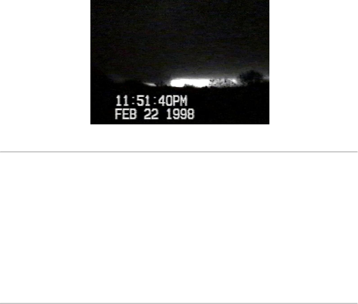
Video of the Winter Garden tornado, looking north from Windermere, about 5 miles away.
As is often the case with tornadoes at night, it only became visible once it was backlit by lightning.
ZCZC MIASVSMLB ALL 230525
TTAA00 KMLB DDHHMM (230451)
FLZ045-2305250
SEVERE WEATHER STATEMENT
NATIONAL WEATHER SERVICE MELBOURNE FL
1151 PM EST SUN FEB 22 1998
...TORNADO ON THE GROUND IN WINTER GARDEN...
AT 1150 PM...HAM RADIO OPERATORS REPORTED A TORNADO ON THE GROUND IN WINTER GARDEN NEAR S.
R. 545 MOVING TOWARDS S.R. 535. THIS STORM IS MOVING TOWARDS OCOEE AND APOPKA. RESIDENTS
IN THIS AREA SHOULD MOVE INTO AN INTERIOR ROOM...AWAY FROM WINDOWS AT ONCE!!
CRISTALDI
&
ZCZC MIATORMLB ALL 230555
TTAA00 KMLB DDHHMM (230456)
FLC117-230555-
BULLETIN - EAS ACTIVATION REQUESTED
TORNADO WARNING
NATIONAL WEATHER SERVICE MELBOURNE FL
1156 PM EST SUN FEB 22 1998
THE NATIONAL WEATHER SERVICE IN MELBOURNE FL HAS ISSUED A
TORNADO WARNING EFFECTIVE UNTIL 1255 AM EST
FOR PEOPLE IN THE FOLLOWING LOCATION...
IN EAST CENTRAL FLORIDA
...SEMINOLE COUNTY
19
http://www.srh.weather.gov/mlb/research.html

AT 1155 PM...WEATHER RADAR SHOWED A STRONG TORNADIC CIRCULATION WITHIN
SEVERE THUNDERSTORMS MOVING TOWARDS APOPKA. THESE STORMS WILL MOVE NORTHEAST AT 45
MPH AND INTO SEMINOLE COUNTY NEAR FOREST CITY ...WEATHERFIELD AND ALTAMONTE SPRINGS. IT
WILL THEN MOVE TO NEAR LONGWOOD...ALTAMONTE SPRINGS...MAITLAND AND LAKE MARY.
THIS STORM HAS A HISTORY OF PRODUCING FUNNEL CLOUDS AND REPORTEDLY PRODUCED A
TORNADO TOUCHDOWN IN THE WINTER GARDEN AREA. IF YOU LIVE IN THIS AREA OF SEMINOLE
COUNTY...TAKE SHELTER NOW!!!
THIS STORM THIS IS A DANGEROUS STORM. ACT QUICKLY. IF YOU ARE IN THE PATH OF THIS
TORNADO MOVE TO A SHELTER IF AVAILABLE. OTHERWISE GO TO A SMALL INTERIOR ROOM ON THE
LOWEST FLOOR POSSIBLE. AVOID WINDOWS. ABANDON CARS AND MOBILE HOMES OR A
REINFORCED BUILDING OR GET INTO A DITCH OR CULVERT.
ZCZC MIANOWMLB
TTAA00 KMLB 230506
SHORT TERM FORECAST
NATIONAL WEATHER SERVICE MELBOURNE FL
1205 AM EST MON FEB 23 1998
AMZ550-570-575-FLZ041-044>047-053-054-058-059-064-230700-
COASTAL WATERS NORTH OF COCOA BEACH-
COASTAL WATERS FROM COCOA BEACH SOUTH–VOLUSIA-LAKE-ORANGE-SEMINOLE- BREVARD-
OSCEOLA-INDIAN RIVER-OKEECHOBEE-ST. LUCIE-MARTIN-
.NOW...
...TORNADO WATCH FOR MOST OF EAST CENTRAL FLORIDA THROUGH 3AM...
THROUGH 2AM...STRONG TO SEVERE THUNDERSTORMS WILL OCCUR FROM TAMPA AND SARASOTA...TO
NEAR LAKELAND...TO NEAR ORLANDO AND KISSIMMEE...TO LEESBURG AND SANFORD...TO DAYTONA
BEACH AND FLAGLER BEACH. SEVERAL OF THESE STORMS WILL LIKELY PRODUCE TORNADOES.
TORNADIC STORMS ARE POSSIBLE OVER NORTH POLK COUNTY NORTH OF LAKELAND...TO ACROSS
WEST ORANGE COUNTY NEAR APOPKA...INTO WEST SEMINOLE COUNTY NEAR LAKE MARY. OTHER
STORMS WILL BE CAPABLE OF DAMAGING WINDS AND LARGE HAIL AS THEY MOVE QUICKLY NORTHEAST AT
45 MPH.
$$
ZCZC MIASVSMLB ALL 230615
TTAA00 KMLB DDHHMM (230511)
FLZ041-044>046-053-2306150
SEVERE WEATHER STATEMENT
NATIONAL WEATHER SERVICE MELBOURNE FL
1211 AM EST MON FEB 23 1998
...TORNADO WARNING FOR LAKE COUNTY UNTIL 1230 AM EST...
...TORNADO WARNING FOR ORANGE COUNTY UNTIL 1240 AM EST...
...TORNADO WARNING FOR SEMINOLE COUNTY UNTIL 1255 AM EST...
AT 1210 AM EST...WEATHER RADAR INDICATED A TORNADO JUST SOUTHWEST OF LONGWOOD
AND ALTAMONTE SPRINGS MOVING NORTHEAST TOWARDS THESE LOCATIONS. THE TORNADO
WILL CONTINUE NORTHEAST TOWARDS LAKE MARY AND THEN SANFORD.
TORNADIC DAMAGE REPORTS HAVE BEEN RECEIVED AT THE NATIONAL WEATHER SERVICE TO
20
http://www.srh.weather.gov/mlb/research.html

INCLUDE DAMAGE AT A CONVENIENCE STORE AT HIGHWAY 525 AND 50 IN WINTER GARDEN. SOME
INJURIES WERE REPORTED. NUMEROUS CARS WERE ALSO REPORTED TO BE DAMAGED.
RESIDENTS IN THE PATH OF THIS TORNADO SHOULD ACT NOW TO PROTECT THEIR LIVES!
SHARP
&
ZCZC MIATORMLB ALL 230615
TTAA00 KMLB DDHHMM (230514)
AMZ550-FLC127-230615-
BULLETIN - EAS ACTIVATION REQUESTED
TORNADO WARNING
NATIONAL WEATHER SERVICE MELBOURNE FL
1214 AM EST MON FEB 23 1998
THE NATIONAL WEATHER SERVICE IN MELBOURNE FL HAS ISSUED A
TORNADO WARNING EFFECTIVE UNTIL 115 AM EST
FOR PEOPLE IN THE FOLLOWING LOCATION...
IN EAST CENTRAL FLORIDA
...VOLUSIA COUNTY
AT 1212 AM EST...WEATHER RADAR INDICATED A TORNADO NEAR LAKE MARY IN SEMINOLE COUNTY
MOVING RAPIDLY NORTHEAST AT 45 MPH. THIS TORNADO WILL ENTER INTO VOLUSIA COUNTY
NEAR DELTONA AND ENTERPRISE...TO NEAR OSTEEN...TO NEAR LAKE ASHBY.
RESIDENTS SHOULD ACT NOW TO PROTECT THEMSELVES!
SHARP
ZCZC MIATORMLB ALL 230620
TTAA00 KMLB DDHHMM (230522)
FLC097-230620-
BULLETIN - EAS ACTIVATION REQUESTED
TORNADO WARNING
NATIONAL WEATHER SERVICE MELBOURNE FL
1222 AM EST MON FEB 23 1998
THE NATIONAL WEATHER SERVICE IN MELBOURNE FL HAS ISSUED A
TORNADO WARNING EFFECTIVE UNTIL 120 AM EST
FOR PEOPLE IN THE FOLLOWING LOCATION...
IN EAST CENTRAL FLORIDA
...NORTHERN OSCEOLA COUNTY
AT 1218 AM EST...WEATHER RADAR INDICATED A POSSIBLE TORNADO ABOUT 8 MILES NORTHEAST
OF LAKELAND MOVING RAPIDLY NORTHEAST AT 45 MPH. THIS SEVERE THUNDERSTORM AND
POSSIBLE TORNADO WILL MOVE INTO NORTHWEST OSCEOLA COUNTY NEAR INTERCESSION
CITY...KISSIMMEE...AND THE ATTRACTIONS AREA. THE STORM WILL LIKELY CONTINUE INTO
21
http://www.srh.weather.gov/mlb/research.html

SOUTHWEST ORANGE COUNTY.
A TORNADO WARNING REMAINS IN EFFECT FOR WESTERN ORANGE COUNTY UNTIL 1240 AM. THIS
WARNING MAY BE EXTENDED.
CARS AND MOBILE HOMES CAN BE TOSSED ABOUT BY TORNADO WINDS. DO NOT TRY TO OUTRUN
A TORNADO IN YOUR VEHICLE. ABANDON VEHICLES AND MOBILE HOMES WHEN THREATENED BY A
TORNADO AND GO TO A STRONG BUILDING. IF NO STRUCTURE IS NEARBY...SEEK SHELTER IN A DITCH
OR LOW SPOT.
SHARP
ZCZC MIASVSMLB ALL 230640
TTAA00 KMLB DDHHMM (230537)
FLZ041-044>046-053-230640-
SEVERE WEATHER STATEMENT
NATIONAL WEATHER SERVICE MELBOURNE FL
1237 AM EST MON FEB 23 1998
...TORNADO WARNING FOR ORANGE COUNTY UNTIL 1240 AM EST...
...TORNADO WARNING FOR SEMINOLE COUNTY UNTIL 1255 AM EST...
...TORNADO WARNING FOR VOLUSIA COUNTY UNTIL 115 AM EST...
...TORNADO WARNING FOR OSCEOLA COUNTY UNTIL 120 AM EST...
...TORNADO WATCH FOR ALL OF EAST CENTRAL FLORIDA EXCEPT MARTIN
COUNTY UNTIL 3AM EST...
AT 1235 AM EST...WEATHER RADAR INDICATED SEVERAL TORNADOES OVER
EAST CENTRAL FLORIDA. ONE WAS NEAR OSTEEN IN VOLUSIA
COUNTY...ANOTHER NEAR OCOEE AND MAITLAND IN ORANGE AND SEMINOLE
COUNTIES..AND YET ANOTHER NEAR INTERCESSION CITY AND KISSIMMEE IN
OSCEOLA COUNTY. THE TORNADOES HAVE BEEN MOVING NORTHEAST AT 45 MPH.
THE ORANGE COUNTY WARNING WILL LIKELY BE EXTENDED VERY SOON.
IF YOU LIVE IN A PATH FROM LAKELAND...TO INTERCESSION CITY AND
KISSIMMEE...TO ORLANDO...TO OCOEE AND SANFORD...TO DELTONA...TO NEW
SMYRNA BEACH AND DAYTONA BEACH...YOU SHOULD BE ON THE LOOK OUT
FOR POSSIBLE TORNADOES APPROACHING FROM THE SOUTHWEST THROUGH 2 AM.
THE LINE OF SEVERE AND TORNADIC STORMS WILL GRADUALLY SHIFT EASTWARD
WITH TIME DURING THE MORNING.
SHARP
22
http://www.srh.weather.gov/mlb/research.html
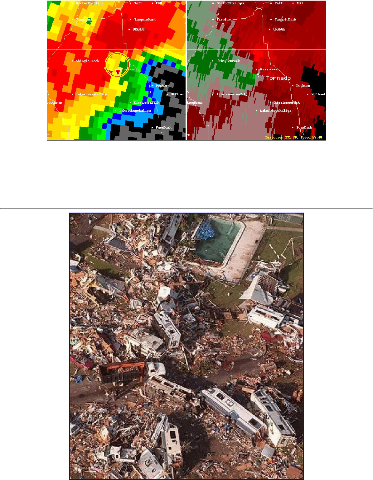
Two-panel image of 0.5 degree base reflectivity (left) and storm relative velocity (SRV, right) from the NWS
Melbourne doppler radar. The image on the left shows the TVS over Kissimmee. The SRV image on the right shows
estimated wind velocity moving either toward (green) or away (red) from the radar, which is about 50 miles southeast
of Kissimmee. Bright red adjacent to bright green indicates strong rotation, which can be clearly seen here, as the
tornado moved through Kissimmee.
23
http://www.srh.weather.gov/mlb/research.html

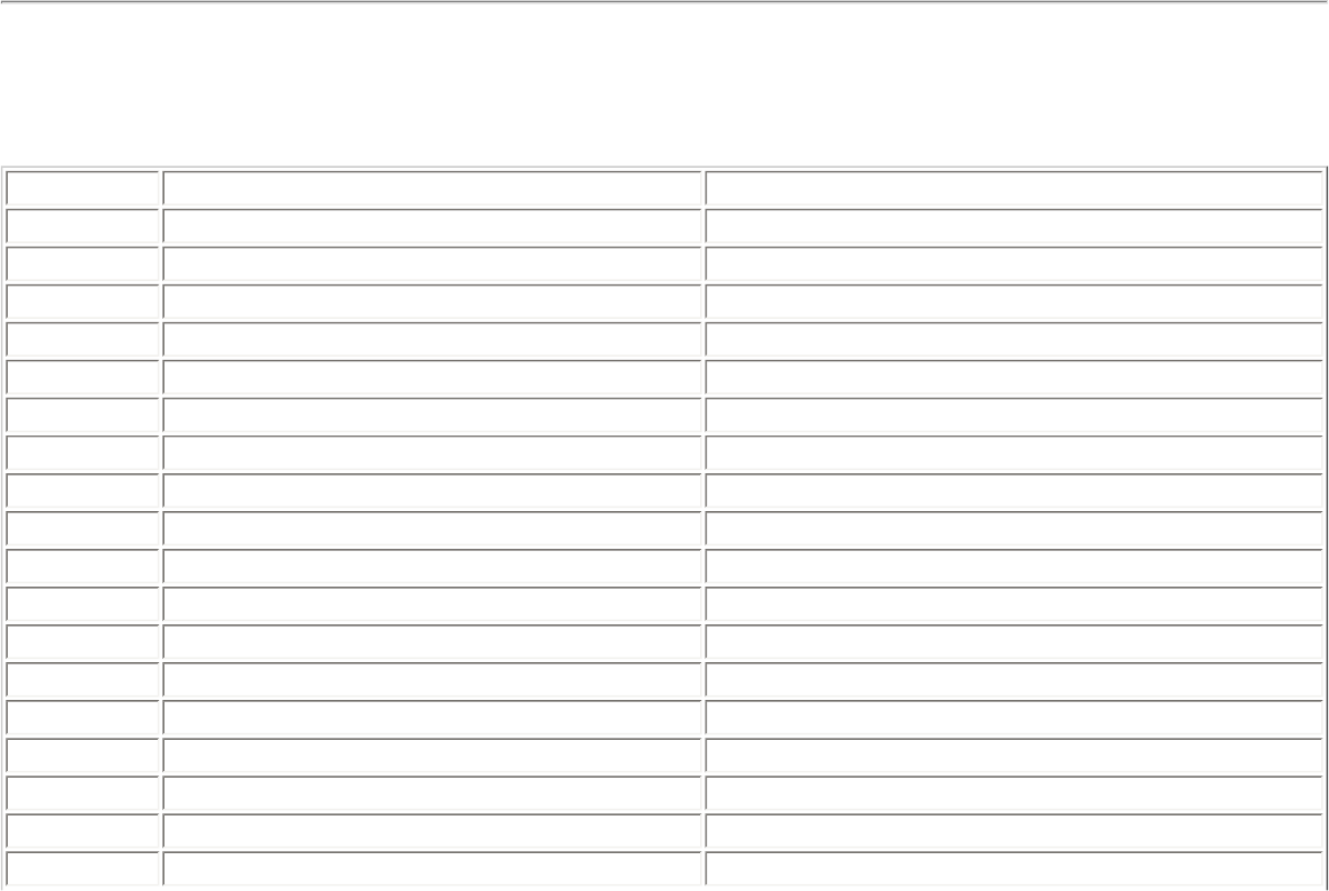
Aerial view of the devastation at the Ponderosa RV Park caused by the Kissimmee Tornado
ZCZC MIATORMLB ALL 230625
TTAA00 KMLB DDHHMM (230540)
FLC095-230625-
BULLETIN - EAS ACTIVATION REQUESTED
TORNADO WARNING
NATIONAL WEATHER SERVICE MELBOURNE FL
1240 AM EST MON FEB 23 1998
THE NATIONAL WEATHER SERVICE IN MELBOURNE FL HAS ISSUED A
TORNADO WARNING EFFECTIVE UNTIL 125 AM EST
FOR PEOPLE IN THE FOLLOWING LOCATION...
IN EAST CENTRAL FLORIDA
...ORANGE COUNTY
AT 1240 AM EST...WEATHER RADAR INDICATED THAT SEVERE TO OCCASIONALLY TORNADIC
THUNDERSTORMS WERE STILL AFFECTING THE COUNTY. A TORNADIC STORM WAS LOCATED
NEAR KISSIMMEE. REPORTS OF FUNNEL CLOUDS WERE BEING RECEIVED AT THE TIME OF ISSUANCE OF
THIS WARNING IN THE KISSIMMEE AREA.
CARS AND MOBILE HOMES CAN BE TOSSED ABOUT BY TORNADO WINDS. DO NOT TRY TO OUTRUN
A TORNADO IN YOUR VEHICLE. ABANDON VEHICLES AND MOBILE HOMES WHEN THREATENED BY A
TORNADO AND GO TO A STRONG BUILDING. IF NO STRUCTURE IS NEARBY...SEEK SHELTER IN A DITCH
OR LOW SPOT.
SHARP
&
MIATORMLB
TTAA00 KMLB 230620
FLC095-097-230720-
BULLETIN - EAS ACTIVATION REQUESTED
TORNADO WARNING
NATIONAL WEATHER SERVICE MELBOURNE FL
119 AM EST MON FEB 23 1998
THE NATIONAL WEATHER SERVICE IN MELBOURNE FL HAS ISSUED A
TORNADO WARNING EFFECTIVE UNTIL 220 AM EST
FOR PEOPLE IN THE FOLLOWING LOCATION...
IN EAST CENTRAL FLORIDA
...ORANGE COUNTY
...OSCEOLA COUNTY
AT 115 AM...RADAR SHOWED SEVERE A TORNADIC LINE OF SEVERE
THUNDERSTORMS FROM BITHLO TO NARCOOSEE AND WEST LAKE TOHO.
24
http://www.srh.weather.gov/mlb/research.html

THESE STORMS WILL CROSS EASTERN ORANGE AND OSCEOLA COUNTIES
AND LIKELY PRODUCE TORNADO TOUCHDOWNS FROM CHRISTMAS TO
NARCOOSEE...AND KISSIMMEE/ST CLOUD.
TORNADOES HAVE ALREADY CLAIMED A LIFE IN VOLUSIA COUNTY!
TAKE SHELTER NOW!!!
IF YOU ARE IN THE PATH OF A TORNADO...ABANDON CARS AND MOBILE
HOMES FOR A REINFORCED BUILDING OR GET INTO A DITCH OR CULVERT.
THE SAFEST PLACE IS AN INTERIOR ROOM SUCH AS A CLOSET ON THE LOWEST
FLOOR OF A STRONG BUILDING. AVOID WINDOWS.
&
MIATORMLB
TTAA00 KMLB 230624
FLC009-230725-
BULLETIN - EAS ACTIVATION REQUESTED
TORNADO WARNING
NATIONAL WEATHER SERVICE MELBOURNE FL
123 AM EST MON FEB 23 1998
THE NATIONAL WEATHER SERVICE IN MELBOURNE FL HAS ISSUED A
TORNADO WARNING EFFECTIVE UNTIL 225 AM EST
FOR PEOPLE IN THE FOLLOWING LOCATION...
IN EAST CENTRAL FLORIDA
...BREVARD COUNTY
AT 120 AM...DOPPLER RADAR SHOWED A TORNADO OVER EASTERN ORANGE
COUNTY BETWEEN CHRISTMAS AND THE S. R. 520 TOLL BOOTH. THIS TORNADO
WILL MOVE INTO NORTHERN BREVARD COUNTY FROM TITUSVILLE TO
MIMS...SCOTTSMOOR...PLAYALINDA BEACH AND THE NORTHERN PART OF CAPE
CANAVERAL.
TORNADOES HAVE ALREADY CLAIMED ONE LIFE IN VOLUSIA COUNTY. TAKE THIS SERIOUSLY!!! MOVE TO
AN INTERIOR ROOM AWAY FROM WINDOWS AT ONCE!!!
THIS IS A DANGEROUS STORM. ACT QUICKLY. IF YOU ARE IN THE PATH OF
THIS TORNADO MOVE TO A SHELTER IF AVAILABLE. OTHERWISE GO TO A SMALL INTERIOR ROOM ON
THE LOWEST FLOOR POSSIBLE. AVOID WINDOWS. ABANDON CARS AND MOBILE HOMES FOR A
REINFORCED BUILDING OR GET INTO A DITCH OR CULVERT.
ZCZC MIATORMLB ALL 230900
TTAA00 KMLB DDHHMM (230804)
FLC097-230900-
BULLETIN - EAS ACTIVATION REQUESTED
TORNADO WARNING
NATIONAL WEATHER SERVICE MELBOURNE FL
304 AM EST MON FEB 23 1998
THE NATIONAL WEATHER SERVICE IN MELBOURNE FL HAS ISSUED A
25
http://www.srh.weather.gov/mlb/research.html

TORNADO WARNING EFFECTIVE UNTIL 400 AM EST
FOR PEOPLE IN THE FOLLOWING LOCATION...
IN EAST CENTRAL FLORIDA
...OSCEOLA COUNTY
AT 300 AM...DOPPLER RADAR SHOWED A SEVERE THUNDERSTORM AND TORNADIC CIRCULATION
DEVELOPING JUST EAST OF THE SOUTH END OF LAKE KISSIMMEE, THE STORM AND POSSIBLE TORNADO
WILL MOVE NORTHEAST AT 45 MPH THROUGH LAKE MARIAN...AND ACROSS THE FLORIDA TURNPIKE TO
NEAR KENANSVILLE BETWEEN 305 AND 320 AM.
IF YOU ARE IN THE PATH OF THIS STORM...TAKE SHELTER IMMEDIATELY!!!
TORNADOES HAVE ALREADY CLAIMED A HALF DOZEN LIVES IN CENTRAL FLORIDA THUS FAR.
IF YOU ARE IN THE PATH OF A TORNADO...ABANDON CARS AND MOBILE
HOMES FOR A REINFORCED BUILDING OR GET INTO A DITCH OR CULVERT.
THE SAFEST PLACE IS AN INTERIOR ROOM SUCH AS A CLOSET ON THE LOWEST
FLOOR OF A STRONG BUILDING. AVOID WINDOWS.
CRISTALDI
ZCZC MIATORMLB ALL 230815
TTAA00 KMLB DDHHMM (230727)
AMZ550-555-FLC009-230815-
BULLETIN - EAS ACTIVATION REQUESTED
TORNADO WARNING
NATIONAL WEATHER SERVICE MELBOURNE FL
227 AM EST MON FEB 23 1998
THE NATIONAL WEATHER SERVICE IN MELBOURNE FL HAS ISSUED A
TORNADO WARNING EFFECTIVE UNTIL 315 AM EST
FOR PEOPLE IN THE FOLLOWING LOCATION...
IN EAST CENTRAL FLORIDA
...BREVARD COUNTY
AT 225 AM EST...WEATHER RADAR INDICATED A TORNADIC THUNDERSTORM
NEAR MERRITT ISLAND OVER NORTH BREVARD COUNTY. THIS STORM WAS MOVING NORTHEAST AT 40
MPH AND WILL MOVE NEAR THE TOWN OF CAPE CANAVERAL BEFORE MOVING OFFSHORE.
CARS AND MOBILE HOMES CAN BE TOSSED ABOUT BY TORNADO WINDS. DO NOT TRY TO OUTRUN
A TORNADO IN YOUR VEHICLE. ABANDON VEHICLES AND MOBILE HOMES WHEN THREATENED BY A
TORNADO AND GO TO A STRONG BUILDING. IF NO STRUCTURE IS NEARBY...SEEK SHELTER IN A DITCH
OR LOW SPOT.
SHARP
ZCZC MIATORMLB ALL 230915
TTAA00 KMLB DDHHMM (230816)
AMZ550-555-FLC009-230915-
26
http://www.srh.weather.gov/mlb/research.html
BULLETIN - EAS ACTIVATION REQUESTED
TORNADO WARNING
NATIONAL WEATHER SERVICE MELBOURNE FL
316 AM EST MON FEB 23 1998
THE NATIONAL WEATHER SERVICE IN MELBOURNE FL HAS ISSUED A
TORNADO WARNING EFFECTIVE UNTIL 415 AM EST
FOR PEOPLE IN THE FOLLOWING LOCATION...
IN EAST CENTRAL FLORIDA
...BREVARD COUNTY
AT 315 AM EST...WEATHER RADAR INDICATED A TORNADIC THUNDERSTORM OVER CENTRAL OSCEOLA
COUNTY ABOUT SEVEN MILES NORTHWEST OF KENANSVILLE MOVING EAST AT 45 MPH. THIS STORM
AND OTHER STRONG TO SEVERE THUNDERSTORMS WILL AFFECT BREVARD COUNTY DURING THE NEXT
HOUR. THE GREATEST THREAT FOR SEVERE WEATHER AND TORNADOES OVER BREVARD COUNTY WILL
BE SOUTH OF CAPE CANAVERAL NEAR PATRICK
AFB...ROCKLEDGE...AND MELBOURNE.
IF YOU ARE IN THE PATH OF A TORNADO...ABANDON CARS AND MOBILE
HOMES FOR A REINFORCED BUILDING OR GET INTO A DITCH OR CULVERT.
THE SAFEST PLACE IS AN INTERIOR ROOM SUCH AS A CLOSET ON THE LOWEST
FLOOR OF A STRONG BUILDING. AVOID WINDOWS.
SHARP
Chronology of products issued
Sunday, February 22, 1998
Time Product Affected Counties or Areas
5:25 AM Hazardous Weather Outlook All east central Florida counties
11:55 AM Hazardous Weather Outlook All east central Florida counties
8:33 PM Short Term Forecast All except Martin County
9:09 PM Short Term Forecast Lake, Volusia, Orange, Seminole
9:39 PM Short Term Forecast Lake
9:45 PM Tornado Warning Lake
9:58 PM Severe Weather Statement Lake
10:10 PM Severe Weather Statement Lake, Volusia
10:22 PM Tornado Warning Volusia
10:28 PM Short Term Forecast All east central Florida counties
10:33 PM Urban/Small Stream Flood Advisory Northern Lake, Volusia
10:40 PM Hazardous Weather Outlook All east central Florida counties
10:41 PM Severe Weather Statement Lake, Volusia
10:45 PM Local Airport Advisory Daytona Beach International Airport
10:49 PM Special Marine Warning Flagler Beach to Mosquito Lagoon
10:59 PM Severe Weather Statement Lake, Volusia
11:08 PM Severe Weather Statement Volusia
11:20 PM Tornado Warning Volusia
27
http://www.srh.weather.gov/mlb/research.html
11:27 PM Tornado Warning Lake
11:37 PM Tornado Warning Western Orange
11:46 PM Severe Weather Statement Lake, Volusia, Seminole, Orange, Osceola
11:48 PM Local Storm Report Volusia
11:51 PM Severe Weather Statement Orange
11:56 PM Tornado Warning Seminole
Monday, February 23, 1998
Time Product Affected Counties
12:05 AM Short Term Forecast All east central Florida counties
12:11 AM Severe Weather Statement Lake, Volusia, Seminole, Orange, Osceola
12:14 AM Tornado Warning Volusia
12:21 AM Flood Warning Volusia
12:22 AM Tornado Warning Osceola
12:29 AM Local Airport Advisory Orlando International/Executive Airports
12:37 AM Severe Weather Statement Lake, Volusia, Orange, Seminole, Osceola
12:40 AM Flood Warning Orange, Seminole
12:40 AM Tornado Warning Orange
12:53 AM Severe Weather Statement Lake, Volusia, Orange, Seminole, Osceola, Brevard
1:08 AM Severe Weather Statement Volusia, Orange, Seminole, Osceola, Brevard
1:17 AM Short Term Forecast All east central Florida counties
1:19 AM Tornado Warning Orange, Osceola
1:23 AM Tornado Warning Brevard
1:34 AM Severe Weather Statement Brevard
1:50 AM Severe Weather Statement Orange, Osceola, Brevard
2:01 AM Urban/Small Stream Flood Advisory North Brevard
2:25 AM Severe Weather Statement Orange, Osceola, Brevard
2:27 AM Tornado Warning Brevard
2:46 AM Severe Weather Statement Brevard
2:53 AM Special Marine Warning Flagler Beach to Melbourne Beach
3:00 AM Short Term Forecast All east central Florida counties
3:04 AM Tornado Warning Osceola
3:13 AM Severe Weather Statement Osceola, Brevard, Indian River
3:13 AM Severe Weather Statement (cor.) Osceola, Brevard, Indian River
3:16 AM Tornado Warning Brevard
3:34 AM Urban/Small Stream Flood Advisory Central and Southern Brevard
4:01 AM Severe Weather Statement Osceola, Brevard
4:18 AM Short Term Forecast All east central Florida counties
4:19 AM Severe Weather Statement Brevard
6:00 AM Public Information Statement All east central Florida counties
6:20 AM Local Storm Report All east central Florida counties
ZCZC MIAFFWMLB ALL 230840
28
http://www.srh.weather.gov/mlb/research.html

TTAA00 KMLB DDHHMM (230540)
FLC095-117-230840-
BULLETIN - EAS ACTIVATION REQUESTED
FLOOD WARNING
NATIONAL WEATHER SERVICE MELBOURNE FL
1240 AM EST MON FEB 23 1998
THE NATIONAL WEATHER SERVICE IN MELBOURNE FL HAS ISSUED A
FLOOD WARNING EFFECTIVE UNTIL 340 AM EST
FOR PEOPLE IN THE FOLLOWING LOCATION...
IN EAST CENTRAL FLORIDA
...SEMINOLE COUNTY
...ORANGE COUNTY
AT 1235 AM ...THUNDERSTORMS WITH VERY HEAVY RAINFALL WILL MOVE
NORTHEAST ACROSS METRO ORLANDO. THIS COMBINED WITH RAINFALL
FROM PREVIOUS STORMS IN THE PAST FEW HOURS WILL AGGRAVATE
ONGOING FLOODING FROM THE PAST WEEK AND CAUSE ADDITIONAL
AREAS TO EXPERIENCE FLOODING.
BE ESPECIALLY CAUTIOUS AT NIGHT WHEN IT IS HARDER TO RECOGNIZE THE
DANGERS OF FLOODING. DO NOT DRIVE YOUR VEHICLE INTO AREAS WHERE
WATER COVERS THE ROADWAY. THE WATER DEPTH MAY BE TOO GREAT TO
ALLOW YOUR CAR TO CROSS SAFELY. VEHICLES CAUGHT IN RISING WATER
SHOULD BE ABANDONED QUICKLY. MOVE TO HIGHER GROUND.
ZCZC MIASMWMLB
TTAA00 KMLB 230350
AMZ550-230550-
BULLETIN - IMMEDIATE BROADCAST REQUESTED
SPECIAL MARINE WARNING
NATIONAL WEATHER SERVICE MELBOURNE FL
1049 PM EST SUN FEB 22 1998
THE NATIONAL WEATHER SERVICE IN MELBOURNE FL HAS ISSUED A
SPECIAL MARINE WARNING EFFECTIVE UNTIL 1250 AM EST
FOR THE INTRACOASTAL WATERS, BARRIER ISLANDS AND NEARSHORE ATLANTIC FROM...
...FLAGLER BEACH TO MOSQUITO LAGOON
AT 1048 PM...DOPPLER RADAR SHOWED SEVERE THUNDERSTORMS APPROACHING THE VOLUSIA
COUNTY COAST FROM PORT ORANGE TO FLAGLER BEACH. THESE STORMS WILL LIKELY PRODUCE
STRONG DAMAGING GUSTS...HAIL...NEAR CONTINUOUS LIGHTNING AND POSSIBLE TORNADIC
WATERSPOUTS OVER THE INTRACOASTAL AND NEARSHORE ATLANTIC WATERS NORTH OF
MOSQUITO LAGOON.
AS THESE THUNDERSTORMS CROSS THE INTRACOASTAL WATERS, BARRIER
ISLANDS AND INTO THE ATLANTIC...THEY WILL PRODUCE STRONG GUSTY
WINDS, ROUGH SEAS, HEAVY DOWNPOURS AND DANGEROUS LIGHTNING. TRY
TO AVOID THESE STORMS IF POSSIBLE. IF YOU GET CAUGHT OFFSHORE...
MAKE SURE ALL SAFETY GEAR IS AVAILABLE AND THAT LIFE JACKETS ARE
BEING WORN BY YOU AND YOUR CREW.
29
http://www.srh.weather.gov/mlb/research.html

A WATERSPOUT IS A TORNADO OVER WATER THAT CAN BE DANGEROUS AND EVEN DEADLY. SMALL
CRAFT CAN BE SWAMPED OR OVERTURNED BY A WATERSPOUT. STAY AWAY FROM THEM AT ALL TIMES.
CRISTALDI
ZCZC MIAFFSMLB ALL 230540
TTAA00 KMLB DDHHMM (230333)
FLZ041-044-230540-
BULLETIN - IMMEDIATE BROADCAST REQUESTED
URBAN AND SMALL STREAM FLOOD ADVISORY
NATIONAL WEATHER SERVICE MELBOURNE FL
1033 PM EST SUN FEB 22 1998
...URBAN AND SMALL STREAM FLOOD ADVISORY FOR NORTHERN LAKE AND
VOLUSIA COUNTIES UNTIL MIDNIGHT...
AT 1030 PM...RADAR SHOWED SEVERE THUNDERSTORMS LIKELY PRODUCING HAIL AND TORRENTIAL
RAINFALL AMOUNTS OF TWO INCHES IN ABOUT AN HOUR OVER NORTH LAKE COUNTY...ABOUT TO CROSS
THE ST JOHNS RIVER INTO VOLUSIA COUNTY FROM NEAR DELEON SPRINGS TO PIERSON. THE MAIN AREA
OF CONCERN IS ALONG AND NORTH OF STATE ROUTE 44 IN BOTH COUNTIES.
THIS AMOUNT OF RAINFALL WILL LIKELY CAUSE FLOODING OF ROADS AND
OTHER POOR DRAINAGE AREAS. IN ADDITION...STANDING WATER PROBLEMS
ALONG THE ST JOHNS RIVER WILL LIKELY BE AGGRAVATED.
BE ESPECIALLY CAUTIOUS AT NIGHT WHEN IT IS HARDER TO RECOGNIZE THE
DANGERS OF FLOODING. DO NOT DRIVE YOUR VEHICLE INTO AREAS WHERE
WATER COVERS THE ROADWAY. THE WATER DEPTH MAY BE TOO GREAT TO ALLOW YOUR CAR TO
CROSS SAFELY. VEHICLES CAUGHT IN RISING WATER SHOULD BE ABANDONED QUICKLY.
DO NOT ATTEMPT TO CROSS LOW SPOTS IF WATER COVERS THE ROADWAY. NEVER TRY TO CROSS
A FLOWING STREAM...EVEN A SMALL ONE...ON FOOT.
CRISTALDI
ZCZC MIATAPMLB ALL
TTAA00 KMLB DDHHMM (230529)
LOCAL AIRPORT ADVISORY
NATIONAL WEATHER SERVICE MELBOURNE FL
1229 AM EST MON FEB 23 1998
A LOCAL AIRPORT ADVISORY IS IN EFFECT FOR ORLANDO INTERNATIONAL AND
EXECUTIVE AIRPORTS FOR THUNDERSTORMS EXPECTED TO PRODUCE WIND
GUSTS OF 35 KNOTS OR GREATER AND HAIL 1/2 INCH IN DIAMETER OR
LARGER UNTIL 23/230 AM.
LASCODY
ZCZC MIATAPMLB ALL
30
http://www.srh.weather.gov/mlb/research.html
TTAA00 KMLB DDHHMM (230345)
LOCAL AIRPORT ADVISORY
NATIONAL WEATHER SERVICE MELBOURNE FL
1045 PM EST SUN FEB 22 1998
A LOCAL AIRPORT ADVISORY IS IN EFFECT FOR DAYTONA BEACH INTERNATIONAL AIRPORT
FOR THUNDERSTORMS EXPECTED TO PRODUCE WIND GUSTS OF 35 KNOTS OR GREATER...HAIL OF ½ INCH
IN DIAMETER OR LARGER...AND EXCESSIVE LIGHTNING UNTIL 1130 PM.
STORM PRODUCING LARGE AMOUNT OF LIGHTNING AND POSSIBLE TORNADIC
CIRCULATION WILL PASS NEAR DAB AIRPORT BETWEEN 11PM AND 1130PM.
CRISTALDI
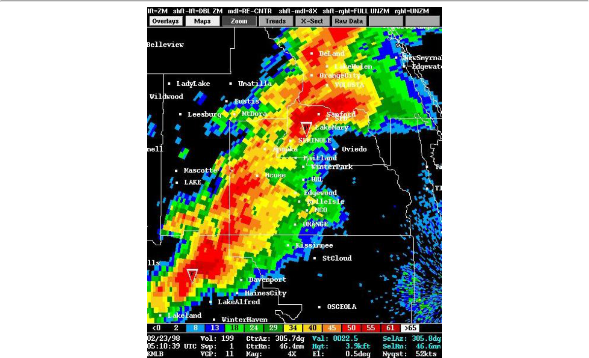
0.5 degree base reflectivty image from the NWS Melbourne doppler radar, displayed using RADS software (developed by
the National Severe Storms Laboratory, NSSL). This image shows "Tornadic Vortex Signatures" or TVS, (red
inverted triangles) indicating tornadic circulations within the storms approaching both Kissimmee (lower left) and
Sanford (upper center).
31
http://www.srh.weather.gov/mlb/research.html
