Undersea Internet Cables Can Detect Earthquakes—
and May Soon Warn of Tsunamis
By Jeffrey Marlow, The New Yorker July 26th, 2022
Volume 24, Number 4
IN THIS ISSUE:
Undersea Internet
Cables Can Detect
Earthquakes
1
NTHMP Summer
Meeting Recap
6
Mapping and Modeling
Subcommittee Summer
Meeting
7
Mitigation and Education
Subcommittee Summer
Meeting
9
Warning Coordination
Subcommittee Hazard
Simplification Update
10
Shoalwater Bay Tribe
Tsunami Vertical
Evacuation Structure
Dedication
11
Tsunami Hazard Maps
for Puget Sound from a
Large Seattle Fault
Scenario
13
New Tsunami
Simulation Videos for
Central Puget Sound
14
General Aviation Pilots
Drill in Preparation for
the Big One
15
Tsunami Research
16
NTHMP Related Events
16
AUGUST 2022
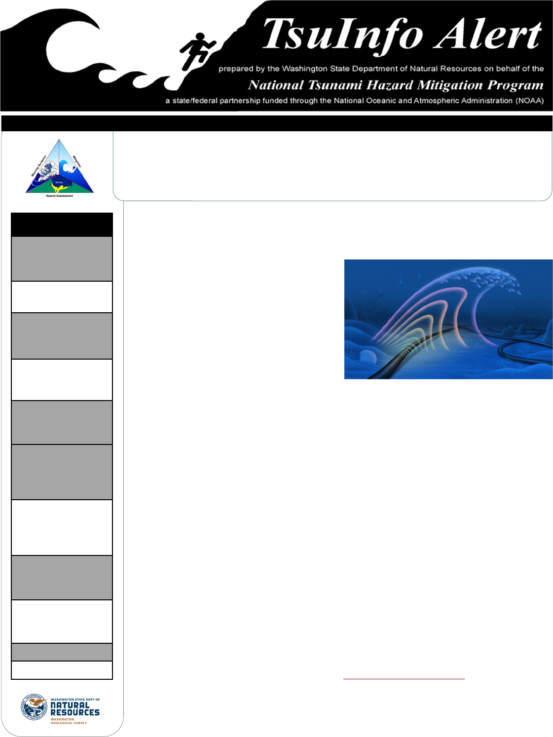
Somewhere beneath the Adriatic Sea, a rogue block of the African tectonic plate is burrowing
under southern Europe, stretching Italy eastward by a few millimetres each year. On October
26, 2016, the stress triggered an earthquake in the Apennine Mountains, one in a series of
quakes which toppled buildings in Italian
towns.
On the day of the tremor, Giuseppe Marra, a
principal research scientist at the National
Physical Laboratory in Teddington, England,
was running an experiment that beamed an
ultra-stable laser through underground fibre-
optic cables. It was part of a larger effort to
build one of the world’s most accurate clocks,
capable of measuring time to the nearest quintillionth of a second. Almost a thousand miles
away from his native Italy, Marra did not feel the quake, but he heard about it on the news.
The next morning, he walked to work to review the results of his experiment.
The light of a laser can be studied as a wave, and, as Marra looked at the data on his computer
screen, he noticed what he called “a small wiggle” in the oscillations. In the language of physics,
the phase had changed. As Marra tried to understand why, he recalled the earthquake, checked
the timing, and found that his wiggle occurred at the same time as the squiggles on a British
Geological Survey seismogram. In other words, the earthquake had caused a miniscule delay in
the arrival of the laser’s light. He calculated that it must have nudged the underground cable by
less than a millimetre. Marra had stumbled onto a new way to detect earthquakes.
Scientists have deployed many seismometers on land but relatively few on the seafloor, where
the cost of installation is often prohibitive. Yet earthquakes beneath the ocean, and the tsuna-
mis they cause, are some of the most destructive and deadly natural disasters. In 2004, a 9.1-
magnitude tremor near Sumatra created a tsunami that killed an estimated two hundred and
thirty thousand people. In 2011, a 9.1-magnitude quake near Japan caused a tsunami that killed
nearly twenty thousand people and led to the Fukushima nuclear disaster. If scientists could
anticipate the movements of tectonic plates, or provide early warning of tsunamis, it would be
a major, life-saving advance.
(Continues on page 2)
Illustration by Lina Müller
2
Undersea Internet Cables Can Detect Earthquakes—
and May Soon Warn of Tsunamis
By Jeffrey Marlow, The New Yorker July 26th, 2022
(Continued from page 1)
TsuInfo Alert
Prepared and published bimonthly by the Washington State
Department of Natural Resources, Washington Geological Survey,
on behalf of the National Tsunami Hazard Mitigation Program (NTHMP),
a state/federal partnership led by the National Oceanic and Atmospheric Administration (NOAA).
This publication is free upon request and is available in print by mail and online at:
http://www.dnr.wa.gov/programs-and-services/geology/geologic-hazards/tsunamis/tsuinfo-alert
Assembled and edited by Stephanie Earls,
Librarian, Washington Geological Survey
Washington Dept. of Natural Resources
1111 Washington St. SE, MS 47007
Olympia, WA 98504-7007
360-902-1473 (p) 360-902-1785 (f)
The views expressed herein are those of the authors and not necessarily those of NOAA, the Washington Department of Natural Resources, or other sponsors of TsuInfo Alert.
NATIONAL TSUNAMI HAZARD MITIGATION PROGRAM LIBRARY CATALOG:
http://d92019.eos-intl.net/D92019/OPAC/Index.aspx
Marra was not the first scientist to consider the earthquake-sensing potential of undersea cables. An older method
called Distributed Acoustic Sensing, for example, analyzes the light that reflects off imperfections in glass fibres, and has
been used to sense earthquakes and map microfaults. But D.A.S. has a crucial limitation: it can only provide data near
the ends of each cable. It doesn’t work in the much longer stretches of cable that rely on repeaters, or cylindrical
electronics boxes that boost signals during their journey under the ocean.
More than 1.2 million kilometres of cable—enough to stretch from the Earth to the moon about three times over—
crisscross the ocean floor. These cables, which are typically funded by the telecom industry and technology companies
such as Facebook and Google, are the hidden infrastructure that make the Internet possible. If scientists could persuade
companies to share, Marra’s accidental discovery could allow them to detect earthquakes, in addition to their normal
function. “This is not how telecommunications cables are usually meant to work,” Marra said. “But turning them into
sensors becomes a possible game changer at the bottom of the sea.”
Scientists know surprisingly little about the inner workings of our planet. The deepest ocean-drilling efforts have
collected samples from less than five miles beneath the Pacific. Given the size of the Earth, that’s a bit like poking
through the skin of an apple; neither tells you very much about what’s inside.
(Continues on page 3)

3
Earthquakes do something that humans and their instruments cannot: they pass through the crust into the molten
center of the planet. As seismic waves move through the crust, mantle, and core, they illuminate the Earth’s structure in
roughly the same way that an X-ray illuminates muscle, bone, and cartilage, Zhongwen Zhan, a professor of geophysics
at the California Institute of Technology, told me.
The areas where oceanic plates dive beneath continents, known as underwater subduction zones, are particularly
mysterious, Zhan said. Many of the worst earthquakes happen there, and the zones often run parallel to densely
inhabited coastlines, for hundreds of miles. “We suspect that earthquakes in the ocean are fundamentally different from
the ones we have on land,” Zhan said. “Could the plate boundaries be physically different? Is there some kind of
different physics there that we don’t know about?”
Some recent studies suggest that plates in subduction zones not only rupture suddenly but can also creep slowly,
perhaps over the course of a month, in a way that plates in other zones do not. Seafloor seismometers could measure
the creep and map the pressure on different parts of the seafloor, pinpointing the fault zones that are most vulnerable
to larger tremors. “If these faults are capable of having smaller earthquakes,” Erin Wirth, a research geophysicist with
the U.S. Geological Survey, said, “then they’re also likely capable of having larger earthquakes.”
The problem is that there are so few seafloor seismometers to collect data in subduction zones. “That gives you a very
biased view of the interior of the Earth,” Zhan said. “We don’t know how the plates beneath the ocean really behave.”
Underwater cables, he added, could change that.
The first transatlantic telegraph cables—the ancestors of today’s fibre-optic technology—were draped across the
seafloor in the middle of the nineteenth century. They were the moonshots of their day and collapsed the
communication time between Europe and North America from ten days to a few minutes. After the first transmissions,
in 1858, the New York Herald declared that “everybody seemed crazy with joy”; the Times worried that rapid
communications would prove “superficial, sudden, unsifted, too fast for the truth.” But early cables often short-circuited
or were severed by rogue anchors, and the first transatlantic connection lasted only three weeks.
Even then, cables provided an unexpected window into hidden parts of the planet. At the time, naturalists believed that
the deep sea was a barren wasteland; based on a fruitless sampling effort in the Aegean Sea, the renowned naturalist
Edward Forbes calculated that life could not exist underwater below a depth of about five hundred metres. However, in
1860, an engineer hoisted a broken telegraph cable out of the Mediterranean and found animals affixed to it. The cable
had spent two years between Sardinia and Algeria, at a depth of more than two thousand metres. “It really was a
turning point,” Helen Rozwadowski, a history professor at the University of Connecticut, said. “The cable was
encrusted with life—I mean, there was no way it could have just hopped on.” The discovery reinvigorated deep-sea
science and helped inspire pivotal missions such as the Challenger expedition, which discovered thousands of unknown
marine species when it circumnavigated the globe in the eighteen-seventies.
In the nineteen-eighties, glass fibres that carried light began to replace copper wires that transmitted electrical pulses.
Light has the ability to carry information on many different wavelengths, which are known in the industry as channels. As
bandwidth skyrocketed, fibre-optic cables grew into a kind of nervous system for the Internet and its many associated
technologies.
(Continues on page 4)
TSUNAMI DETECTION
Undersea Internet Cables Can Detect Earthquakes—
and May Soon Warn of Tsunamis
By Jeffrey Marlow, The New Yorker July 26th, 2022
(Continued from page 2)

4
“It has always been the case that cables get laid first and then people begin trying to think of new ways to use them,” the
sci-fi novelist Neal Stephenson wrote in Wired in 1996. “Once a cable is in place, it tends to be treated not as a
technological artifact but almost as if it were some naturally occurring mineral formation that might be exploited in any
number of different ways.”
Each cable is roughly the thickness of a garden hose, but it’s mostly a protective sheath around a dozen thin strands of
glass, which are so pure that a kilometre-thick block would appear as clear as a freshly washed windshield. Today, about
three hundred cables carry ninety-nine per cent of transoceanic data traffic.
Bruce Howe, an oceanographer at the University of Hawaii, has been adding scientific instruments to seafloor cables
since the early nineteen-nineties. Telecom companies lay new cables roughly once every quarter century to preëmpt
disruptions and incorporate more advanced materials. “Whenever a company decides to turn their cable system off,
instead of abandoning it in place, as was done in those days, we thought science could use it,” he told me.
In the late aughts, Howe led the years-long installation of part of the ALOHA Cabled Observatory, which built on an old
AT&T cable situated a hundred kilometres north of Oahu. He and colleagues later wrote that the team struggled to link
their instruments to the cable, and the facility struggled to reach its full potential, owing in part to “still-all-too-common
cable and connector problems.”
Similar attempts to co-opt mothballed cables also stumbled. In 1998, scientists added a seismometer, a hydrophone, two
pressure gauges, and other instruments to an obsolete cable that linked Hawaii and California, but the system failed
after just five years. One system near Hawaii developed a short circuit six months after deployment, and another was
damaged by fishing activity off the coast of Japan. Commercial hand-me-downs weren’t the way forward.
Howe started to wonder whether it was possible to incorporate scientific equipment into operational telecom cables,
which are meticulously maintained by the companies that profit from them. He and his colleagues designed temperature,
pressure, and seismology probes that would fit snugly into cable repeaters. “The telecom people were adamant that
they wanted nothing to do with us,” Howe told me. As he tells the story, they replied, “No way, because it would affect
the reliability of the telecom.” This response disappointed the scientists, who would later estimate that piggybacking on
cable infrastructure would give researchers data at a tenth of the cost of building their own system from scratch.
Installing a transatlantic cable takes two to three years and about two hundred million dollars, according to Nigel Bayliff,
the C.E.O. of the cable operations firm Aqua Comms. A single repair can cost two million dollars. Any change to a
functioning system—even a modest science package added at no cost to the cable company—could become a liability.
“It’s a bit like asking for a different toilet on the space station,” Bayliff told me. “It’s, like, ‘Really, guys? Do you really
want to risk the whole space station to change the toilet?’ ”
“The only business reason for these cables to exist, as far as we are concerned, is for data connectivity,” Bikash Koley,
the vice-president of global networking at Google, which has laid long stretches of cable in partnership with telecom
carriers, told me. The company has no intention of adding instruments to its cables, he said.
There are legal obstacles, too. Because seafloor telecom cables are treated as an essential public service, they receive
certain freedoms under the United Nations Convention on the Law of the Sea, but the nebulous category of “marine
scientific research” does not necessarily receive the same privileges. Bayliff worries about what could happen to telecom
projects if they contribute to science.
(Continues on page 5)
TSUNAMI DETECTION
Undersea Internet Cables Can Detect Earthquakes—
and May Soon Warn of Tsunamis
By Jeffrey Marlow, The New Yorker July 26th, 2022
(Continued from page 3)

5
“Is ninety-per-cent telecom, ten-per-cent science now a science cable?” Bayliff asked. We might not know until a first
mover tests the legal waters. But he added that governments might be able to solve this problem by mandating
collaboration between companies and researchers. “Once this becomes the norm, then it will just happen all the time
and no one will worry, because the risks will all be the same for everybody,” he said.
Howe and his team ultimately collaborated with the government of Portugal, which was planning to replace its aging
cable system—and which knows something about offshore earthquakes. In 1755, a massive quake southwest of Lisbon
caused a tsunami and devastated the capital. Tens of thousands died.
“They’re motivated,” Howe told me. “They see this in terms not just of telecom operational costs but in human costs,
and it may take governments to really balance these kinds of considerations. Companies aren’t going to do that.” The
Portuguese government has approved the project, and Howe expects the appropriation of at least a hundred and
twenty million euros to happen sometime this year. The cable will connect Lisbon, the Azores, and the island of
Madeira; once it’s operational, in 2025, motion, pressure, and temperature sensors in the cable’s repeaters will serve as
a seafloor science platform and a tsunami-warning system.
In order for scientists to break the stalemate with the cable industry, they needed ways to use data that already exists,
without modifying undersea cables or repeaters. Marra’s serendipitous discovery proved that this was possible.
Then, in 2020, Google agreed to share measurements of light polarization from its fibre-optic network with a scientific
team that included Zhan and other researchers from Caltech and the University of L’Aquila, in Italy. Koley told me that
Google scientists were happy to collaborate—as long as they didn’t need to add instruments to their cables. “This was a
set of data that you would actually throw away otherwise,” Koley said. “It has no other use to us.”
The researchers identified shifts in the polarization that occur when cables bend, twist, and stretch, and cross-
referenced the changes with dozens of earthquakes that seismometers detected over a nine-month period. This
approach isn’t as sensitive as Marra’s method or D.A.S., but it doesn’t require sophisticated technology in the form of an
advanced laser. “Because the method is so easy to implement, we actually now have six or seven cables on board,
providing data,” Zhan said.
Last year, Google gave Marra and his team access to a cable-landing station in Southport, England, where the company
used a cable that extends to Dublin, and then on to Halifax, Canada. The company was willing to give the researchers
temporary access to certain channels when it wasn’t using them. The researchers drove five hours from their laboratory
in Teddington and installed customized lasers and detectors, as well as computers that they could access remotely. They
now had the power to detect phase shifts beneath the Irish Sea and the Atlantic Ocean.
But they still needed a way to determine where the phase shifts were happening in order to figure out the exact
location of seafloor movements. To solve this problem, the researchers took advantage of tiny mirrors that are built
into fibre-optic repeaters, which normally help technicians diagnose problems along specific stretches of cable. The
hundred and twenty-eight mirrors between Southport and Halifax allowed them to identify the specific portion of cable
where a phase shift first occurred. Their approach had the potential to turn the cable into a hundred and twenty-nine
localized earthquake detectors.
(Continues on page 6)
TSUNAMI DETECTION
Undersea Internet Cables Can Detect Earthquakes—
and May Soon Warn of Tsunamis
By Jeffrey Marlow, The New Yorker July 26th, 2022
(Continued from page 4)
6
Marra’s team succeeded in its earthquake-sensing work: they detected and located two tremors. But the experiment
didn’t end there. In November, they were reviewing the data on a daily basis and spotted a phase change in the light
from the cable beneath the Irish Sea. This time, the signal was different from the earthquakes they had measured before.
Marra suspected a different culprit: a cyclone was passing through the area, whipping up waves. The next day, the phase
of the light changed even more, and Marra was able to confirm that it closely matched changes in wave height recorded
by a nearby buoy. He was amazed that the ocean’s waves had such a direct impact on the light’s waves. “It’s really
shouting in your face, the correlation with the wave height,” he told me. “I find that result very beautiful.”
Marra and his team had set out to detect undersea earthquakes, which could hint at where and when a tsunami might
form. They ultimately developed a method that could help scientists track actual tsunamis in real time. Marra said that it
will take time to analyze the data and separate out the contributions of waves, earthquakes, and other environmental
factors. But he envisions a future in which cables could warn coastal communities about the exact location and height of
approaching waves. “We’ve got a chance,” he told me. “I’m not sure we had that before.”
Link to original article:
https://www.newyorker.com/science/elements/undersea-internet-cables-can-detect-earthquakes-and-may-soon-warn-of-tsunamis
[PERMISSION GRANTED TO REPRINT ARTICLE BY CONDÉ NAST ON BEHALF OF THE NEW YORKER]
TSUNAMI DETECTION & NTHMP SUMMER MEETING
Undersea Internet Cables Can Detect Earthquakes—
and May Soon Warn of Tsunamis
By Jeffrey Marlow, The New Yorker July 26th, 2022
(Continued from page 5)
Talking Waves in the Desert
By Ian Sears, NWS Tsunami Program Coordinator
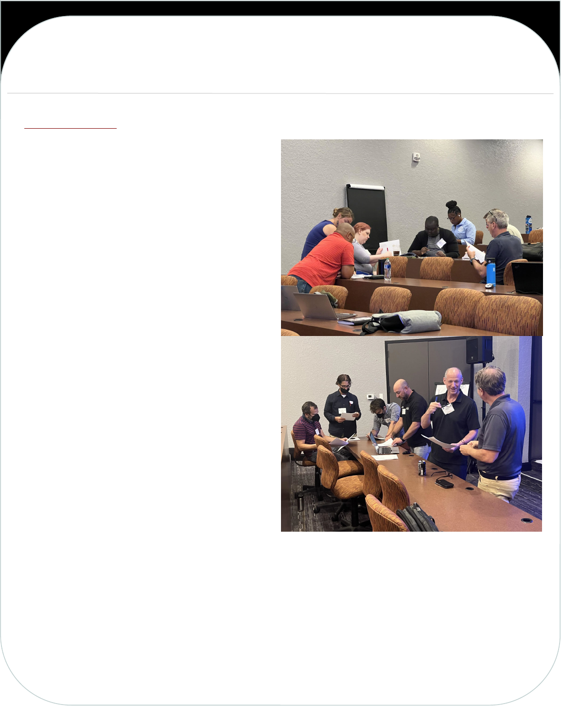
Palm Springs, California in July is an ironic place to hold a meeting about tsunamis and that is just what happened with
the 2022 National Tsunami Hazard Mitigation Program (NTHMP) Summer Meeting. The meeting, hosted by NHTMP
state partner California Office of Emergency Services, brought together NOAA, States and Territories, FEMA, USGS,
Academia, and Industry partners
from July 18 to 22, 2022 to
develop action plans and strategies
that better protect lives and
livelihoods and build communities
resilient to tsunami hazards.
The main theme of the meeting
was service equity and how the
NTHMP can meet the needs of the
underserved and vulnerable through science, education, and warning coordination. Various workshops were held during
the week to gain vital input from partners on topics such as TsunamiReady, Hazard Simplification, FEMA’s National Risk
Index, Tsunami Exercises, and Strategic Planning. NTHMP subcommittees, work groups, and caucuses met to establish
future work plans and priorities, collaborate on various science, education, preparedness, and resilience topics. A
Coordinating Committee Meeting concluded the week to chart the path forward for implementing the feedback and
actions that came out of the meeting.
Learn more about the NOAA Tsunami Program and the NTHMP.
7
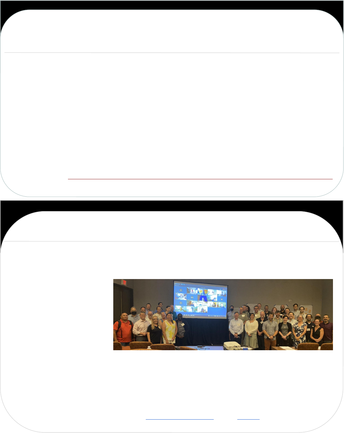
For the first time in two years, many members of the NTHMP traveled far and wide to gather in-person for its annual
summer meeting, which was located in Palm Springs, California. For those unable to attend in person, virtual
participation was also offered as we still fight against the ongoing COVID-19 pandemic. In this hybrid approach of both
in-person and virtual participation, the Mapping and Modeling Subcommittee (MMS) of the NTHMP held a successful
meeting on a variety of topics and discussion. Discussion topics included: (1) the annual work plan, (2) the coordination
of post-tsunami investigations, (3) evacuation modeling, (4) wave arrival times, and (5) lightning talks on specific updates
from each MMS partner.
As part of the MMS annual work plan, Stephanie Ross from the U.S. Geological Survey (USGS) provided an update on
the Powell Center working group, which hopes to increase coordination on common tsunamigenic sources that
transcend state and territory boundaries in an effort to increase consistency in planning. The Powell Center has
scheduled six meetings, of which four have already been completed (developing an approach; Alaska-Aleutian
Subduction Zone [AASZ] sources; US East Coast, Gulf Coast, & Caribbean [landslide and seismic] sources; and Cascadia
Subduction Zone [CSZ] sources). Upcoming meetings will take place in the spring and summer of 2023, which will focus
on Pacific Tsunami Sources other than AASZ and CSZ, and crustal faults and other non-standard tsunami sources,
respectively.
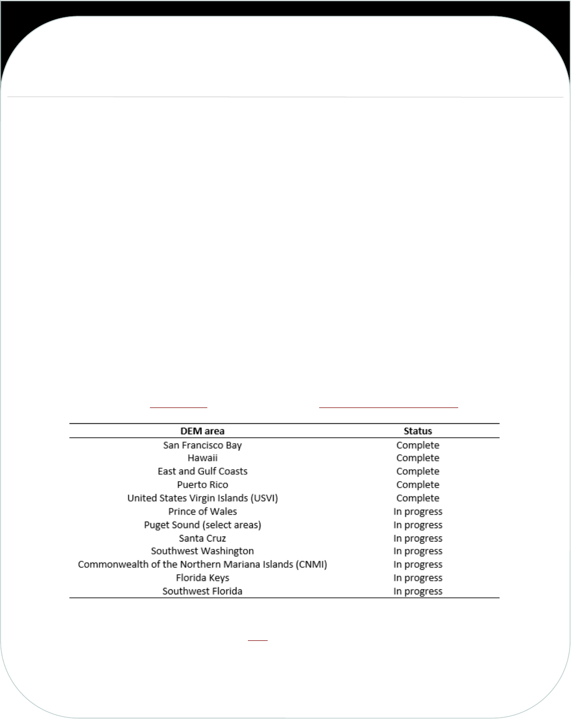
Kelly Carignan of the National Centers for Environmental Information (NCEI) reported on the development progress of
the digital elevation models (DEM) within the annual work plan, recorded in the table below. Completed DEMs are
available for public access via Digital Coast and discoverable via the NCEI Bathymetric Data Viewer.
Additionally, California is leading guidance efforts for maritime communities. Specific information, hazard tools, and
other resources regarding this topic can be viewed here. Tsunami hazard planning and preparedness for maritime
communities is a task that all NTHMP partners are involved with and future efforts will focus on model-based guidance
for the needs of specific harbors, rather than a generic, catch-all approach.
(Continues on page 8)
NTHMP SUMMER MEETING
Mapping and Modeling Subcommittee of the NTHMP
Holds its Summer Meeting in Palm Springs, California
By Alex Dolcimascolo, Washington DNR; Jon Allan, DOGAMI; and Summer Ohlendorf, NTWC
8
The MMS also discussed two upcoming benchmarking workshops on sediment transport and debris flow modeling.
These workshops are tentatively scheduled for summer 2023 (locations TBD) and may be combined into one effort.
The workshop(s) leadership are in the process of recruiting members for an organizing committee to assist with
identifying potential benchmarks and persons responsible for collecting data and documentation for each, in addition to
identifying the pool of potential workshop participants and guest speakers. If interested, please contact Jim Kirby
(sediment) or Pat Lynett (debris) for more information.
Following discussions of the MMS annual work plan and upcoming workshops, Bruce
Jaffe (USGS) presented on the development of the national plan for coordinating post-
tsunami investigations. California and Washington also shared their efforts on their own
post-earthquake information and multi-hazards clearinghouse plans, respectively. These
plans will help streamline the process of facilitating, gathering, and disseminating tsunami
data and information after a major event.
There was also a lively discussion regarding evacuation modeling. Nate Wood (USGS)
shared many updates to the USGS PEAT Pedestrian walk analysis tool, which can now
support evacuation ‘watersheds’ and many comparative analysis features. These
upgrades allow for an easier way to compare different modeling inputs and could help
inform decisions on life and safety, such as determining the best location for Vertical
Evacuation Structure construction. Members of the MMS also showed interest in
including vehicular evacuation in the future, which can be used for scenarios with longer
lead times such as lahar and distant-sourced tsunami.
The MMS also introduced the topic of ‘wave arrival’ and what it may mean to different
groups and stakeholders. NTHMP members expressed interest for the MMS to
schedule an inclusive workshop to address wave arrival, with a goal of developing a
glossary of terms to be used between all NTHMP partners. Keep an eye out for this
workshop in the near future.
Lastly, each present MMS partner gave specific updates in the form of 10-minute lightning talks. We heard updates from
(1) Puerto Rico, (2) US Virgin Islands, (3) Gulf Coast, (4) East Coast, (5) Guam, (6) Commonwealth of the Northern
Mariana Islands, (7) American Samoa, (8) Hawaii, (9) Alaska, (10) Washington, (11) California, (12) NCEI, (13) NOAA
Tsunami Warning Centers, and (14) Oregon. Presentations of each MMS partner can be found on the NTHMP website.
The MMS hopes to reconvene in-person, once again, at the annual NTHMP winter meeting, scheduled for January 23-
27, 2023 in California.
NTHMP SUMMER MEETING
Mapping and Modeling Subcommittee of the NTHMP
Holds its Summer Meeting in Palm Springs, California
By Alex Dolcimascolo, Washington DNR; Jon Allan, DOGAMI; and Summer Ohlendorf, NTWC
(Continued from page 7)
9
The Mitigation and Education Subcommittee (MES) met on Monday, July 18
th
during the weeklong NTHMP July 2022
Summer Meeting. Over 30 people gathered both in person and virtually from NTHMP participating territories, states,
and federal agencies for a day of discussion, sharing, and collaboration.
The meeting began with presentations and
discussions of the NTHMP Strategic Plan and the
UN Decade of Ocean Science, Ocean Decade
Tsunami Programme. These discussions helped set
the stage and frame the MES meeting for the
remainder of the day by highlighting that the
NTHMP Strategic Plan Education and Preparedness
Theme desired outcome is that at risk Individuals
know what to do during a tsunami, and the Ocean
Decade Tsunami Programme main social outcome
is to make 100% of communities at risk to tsunami
prepared and resilient to tsunami by 2030.
MES Partner sharing for the day was kicked off with a Social Media Workshop led by the Washington State Military
Department's Emergency Management Division (WA EMD). This discussion focused on sharing successes, best
practices, and lessons learned with examples from the January 2022 Tonga event. Social Media continues to be a key
tool for MES partners to communicate with communities both before and during tsunami events.
Next on the agenda was a showcase of Hazus Tsunami Model projects that are being worked on by NTHMP Partners
including the U.S. East Coast States, Washington, and California. The Hazus Tsunami Model is the newest of the FEMA
Hazus risk estimation tools and NTHMP partners benefit from the shared experiences navigating the use of the tool and
development of loss estimate products for our coastal areas.
The discussions continued with a presentation on TsunamiZone.org led by the Southern California Earthquake Center
(SCEC) who develops and maintains the website TsunamiZone.org for California and in support of all NTHMP partners.
TsunamiZone.org houses an extensive collection of resources to support tsunami preparedness and has grown to
include ten region specific pages for NTHMP partners. TsunamiZone.org is also used to support and track participant
registrations for annual tsunami preparedness activities and exercises. More than 780,000 participants registered their
tsunami preparedness activities on TsunamiZone.org in 2022.
MES sharing was wrapped up with lightning presentations from NTHMP partners highlighting recent and planned efforts
throughout our regions. NTHMP partners are accomplishing great things to support tsunami preparedness and
resilience throughout our regions. The opportunity for NTHMP partners to share, learn, and ask questions of each
other through the MES is invaluable as we all continue our efforts to support the mission and vision of the NTHMP.
MES at the July 2022 Summer meeting (photo by Christa von Hillebrandt-Andrade)
NTHMP SUMMER MEETING
NTHMP Mitigation and Education Subcommittee
Summer Meeting – July 2022
By Todd Becker, Nic Arcos, Regina Browne
10
The Warning Coordination Subcommittee spent most of the time allotted during the Summer Meeting discussing
Hazard Simplification: the National Weather Service effort to improve response to the Warning, Advisory, Watch
terminology-specifically by eliminating the term
“Advisory”.
Prior to the meeting, the WCS made initial
recommendations to NOAA with suggested phrases to
replace “Tsunami Advisory”. The WCS discussed
several concerns about the overall change requirements
including the risk of deploying any change to current
alert terminology, and the stipulation that the new
headline include the word “Warning”-- in addition to
the continuation of the Tsunami Warning we currently
understand.
The Washington State EMD informed the WCS of a
NTHMP 2022 grant proposal for a “deep dive” research
effort into the requirements and implementation of
replacing the term “Tsunami Advisory”. Using an
additional staff member, Washington State will fully
examine the alert message structure and requirement
for partner states to deploy the new phraseology, then
report back to WCS and NOAA.
During a final interactive session Thursday, the
conference explored “Impact-based decision support-
service ‘tags.’” Tags are short-coding at the end of an
alert that clarify alert levels in a machine-readable
structure that supports automated messaging such as
Wireless Emergency Alert messages. The group
explored and tested their own understanding of one
and two-tier warnings. Concerns were raised about
public versus emergency management understanding and actions, the difficulty in conveying temporal and geographic
changes in alert levels, and the overall difficulty in conveying and acting on a clear message.
WCS members ended the subcommittee sessions with a non-binding vote in favor of a two-tier alert structure
(currently warning and advisory). A final vote will take place in August, with a final recommendation due to the
Coordinating Committee in September for official recommendation to NOAA.
An interactive session at the NTHMP summer meeting guided
participants through an exploration of impact-based decision support “tags”
and investigated the relative usefulness of one or two-tiered alert messages.
NTHMP SUMMER MEETING
Warning Coordination Subcommittee Update
on Hazard Simplification Efforts
By Dave Snider, Tsunami Warning Coordinator, National Tsunami Warning Center
11
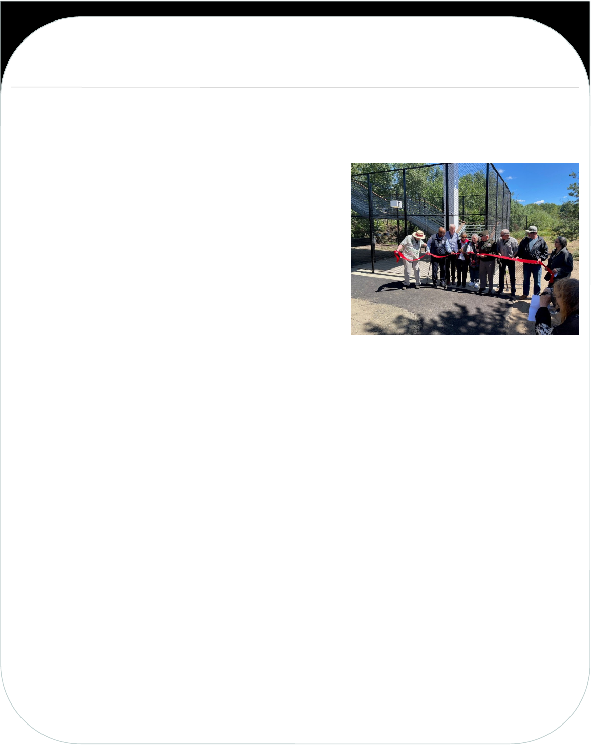
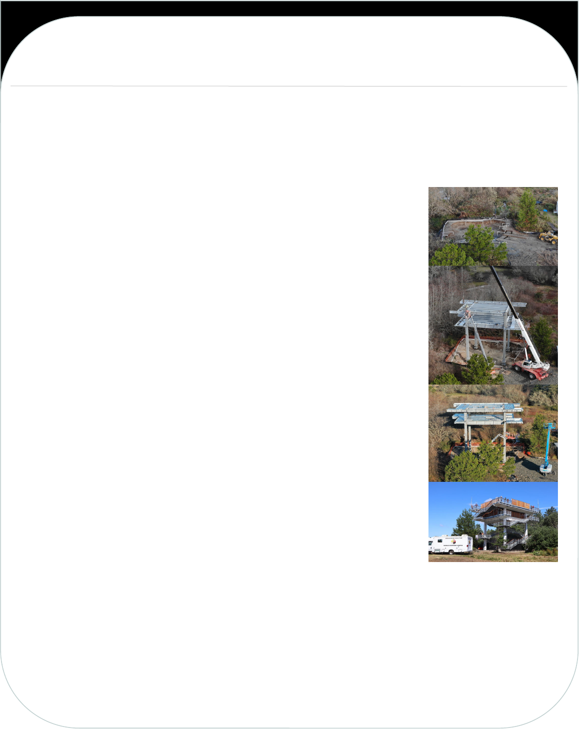
The Shoalwater Bay Indian Tribe had a vision to keep the tribe and surrounding community of Tokeland, Washington
safe from the threat of a tsunami going back nearly 20 years. Nearby high ground was identified and paths were marked
out to offer citizens a place to take refuge. However, the tribe wished to do better. And we did do better with a brand-
new tsunami vertical evacuation tower now in place, which we dedicated in August.
Lee Shipman, the former Emergency Manager for the Shoalwater Bay
Tribe told those at the dedication: “We helped to change the
atmosphere from being helpless victims into one of knowing we can
and will survive if we all work together.”
“Lee did the work,” said Tribal Chairwoman Charlene Nelson. “She
kept us on track and it worked and it could work in any community.
Working together with the tribe and people outside of the tribe, it
makes such a big difference.”
“This tower will save our lives someday,” added Lynn Clark,
Secretary of the Shoalwater Bay Indian Tribe.
The 2011 Tohoku earthquake and tsunami served to remind the
entire world just how devastating a tsunami event can be. The
Shoalwater Bay Tribe began seeking a better form of refuge from this
threat. By 2017, the tribe had formulated a clear picture and plan of
how to provide this place of safety; a vertical evacuation tower
modeled similarly to the Japanese vertical evacuation towers.
Over the next three years, the tribe worked tirelessly with members of academia, local, state and federal government
to develop adequate geologic and tsunami inundation modeling to pursue federal grant funding for a first of its kind
vertical evacuation tower funded by FEMA. These studies significantly punctuated the need for this tower, as it was
revealed a wave as high as 10 feet, travelling at high speed, could make landfall in the Shoalwater Bay/Tokeland area
within 10 – 22 minutes as a result of an 8 – 9 magnitude earthquake emanating from the Cascadia Subduction Zone.
By 2019, the tribe had secured $2.4 million in FEMA grant funding. The COVID pandemic caused nearly a year’s delay in
construction. However, with much determination the project pushed forward. FEMA provided additional funding
amounting to more than $2.8 million with the tribe contributing over $1 million in matching funds.
On May 17, 2021, ground breaking officially commenced on the vertical evacuation tower. The tower was built at the
end of Blackberry Lane, which is about 1.4 miles south from the Tribal Center located at 2373 Tokeland Rd. This
location is on the southern edge of the Shoalwater Bay Indian Tribe Reservation. The tribe decided on this area as it is
approximately in the middle of Tokeland. Thus, it can serve as a place of refuge for not only tribal members, but the
residents of Tokeland as well. In total it will serve to act as a place of refuge for more than 300 full-time residents of
both the reservation and Tokeland.
(Continues on page 12)
TSUNAMI PREPAREDNESS
Shoalwater Bay Tribe Tsunami Vertical Evacuation Structure Dedication
By Kenneth Ufkin, Shoalwater Bay Tribe, and Steven Friederich, WA Emergency Management Division
Ribbon cutting from left to right: Braden Allen, FEMA retired,
Willie Nunn, Director of FEMA Region X, Robert Ezelle,
Director Washington Emergency Management, Charlene Nelson,
Chairwoman Shoalwater Bay Indian Tribe, Lee Shipman,
Shoalwater Bay Emergency Management Director – Retired,
Major General Bret D. Daugherty (Adjutant General) –
Washington Military Dept., Dave Nelson—retired WA EMD
earthquake program coordinator, Shane Thomas, Member at
Large Shoalwater Bay Indian Tribe, Lynn Clark, Secretary
Shoalwater Bay Indian Tribe.
12
The tower is now complete, with only a few minor details still being worked on. The Dedication of the tower occurred
on August 5. Shipman developed the emergency management program for the Tribe and ended her career by getting
this first of its kind vertical evacuation tower project funded and started. So it is only fitting that the tower was
dedicated in her honor and dubbed the “Auntie Lee Tower”. Representatives of FEMA, Washington Emergency
Management and Department of Natural Resources, and many more were in attendance to honor Lee and the
completion of this lifesaving mitigation project. This tower will not only serve as a testament to Lee’s dedication to her
Tribe and community, but to be a place of refuge for generations to come.
The tower is the first of its kind in not just Washington State, but the whole country.
Robert Ezelle, the director of the Washington Emergency Management Division, noted
that he would be looking to the Shoalwater Bay Indian Tribe for advice as more tsunami
towers are built along the coast.
“And as we work, rest assured, all of the tribes and communities will be looking to you
and your inspirations and the lessons learned,” Ezelle said.
“What you’ve done will serve generations to come, not just us,” said Major General
Bret D. Daugherty of the Washington Military Department. “We’re in the window for
this to hit us now. We all know that the day is going to come. It’s not a matter of if, it’s
when and the earth is going to shake violently, much more violently than any of us can
even imagine and the beautiful sea is going to pull back so we can hardly even see it. And
that is going to be the time when the people who live here are going to rush to this
tower, get up those stairs and they are going to be safe. And from the safety of that
tower, people are going to watch as the ocean returns in its fury. And they will be alive
and they will be in awe because they will be survivors of our nation’s worst natural
disaster. That’s what we’re up against here.”
The tower stands 50 feet tall, 40 feet wide, with support piers anchoring it 55 feet
below grade. There are two decks, one at 40 feet, and the other at 50 feet in height.
Each deck has 2,000 square feet for a total of 4,000 square feet. The building
specifications call for one person per 10 square feet making it possible to hold 400
people. Structurally, the tower engineering can hold people shoulder to shoulder
without compromising its structural integrity.
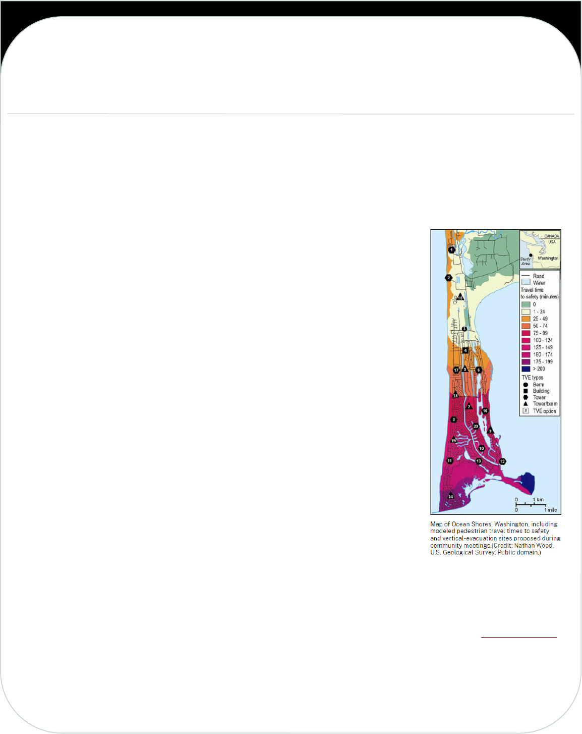
Corina Allen, the Chief Hazards Geologist for the Washington Geological Survey,
presented the tribe with a revised tsunami walking evacuation map showing the new tower in use – and all of the lives
that could be saved. If a big earthquake were to occur, the community would be able to walk to the tower in 15 to 20
minutes. Tsunami inundation maps show the first waves may arrive in 35 minutes, making the tower a true tsunami
refuge.
The level of cooperation between academia and the local, state, and federal emergency management community is truly
commendable. It took considerable dedication from the Washington State Emergency Management Hazard Mitigation
team, advisors from the University of Washington, FEMA, and many others to bring this project to fruition. For that, the
Shoalwater Bay Indian Tribe and citizens of Tokeland are deeply grateful.
TSUNAMI PREPAREDNESS
Shoalwater Bay Tribe Tsunami Vertical Evacuation Structure Dedication
By Kenneth Ufkin, Shoalwater Bay Tribe, and Steven Friederich, WA Emergency Management Division
(Continued from page 11)
13
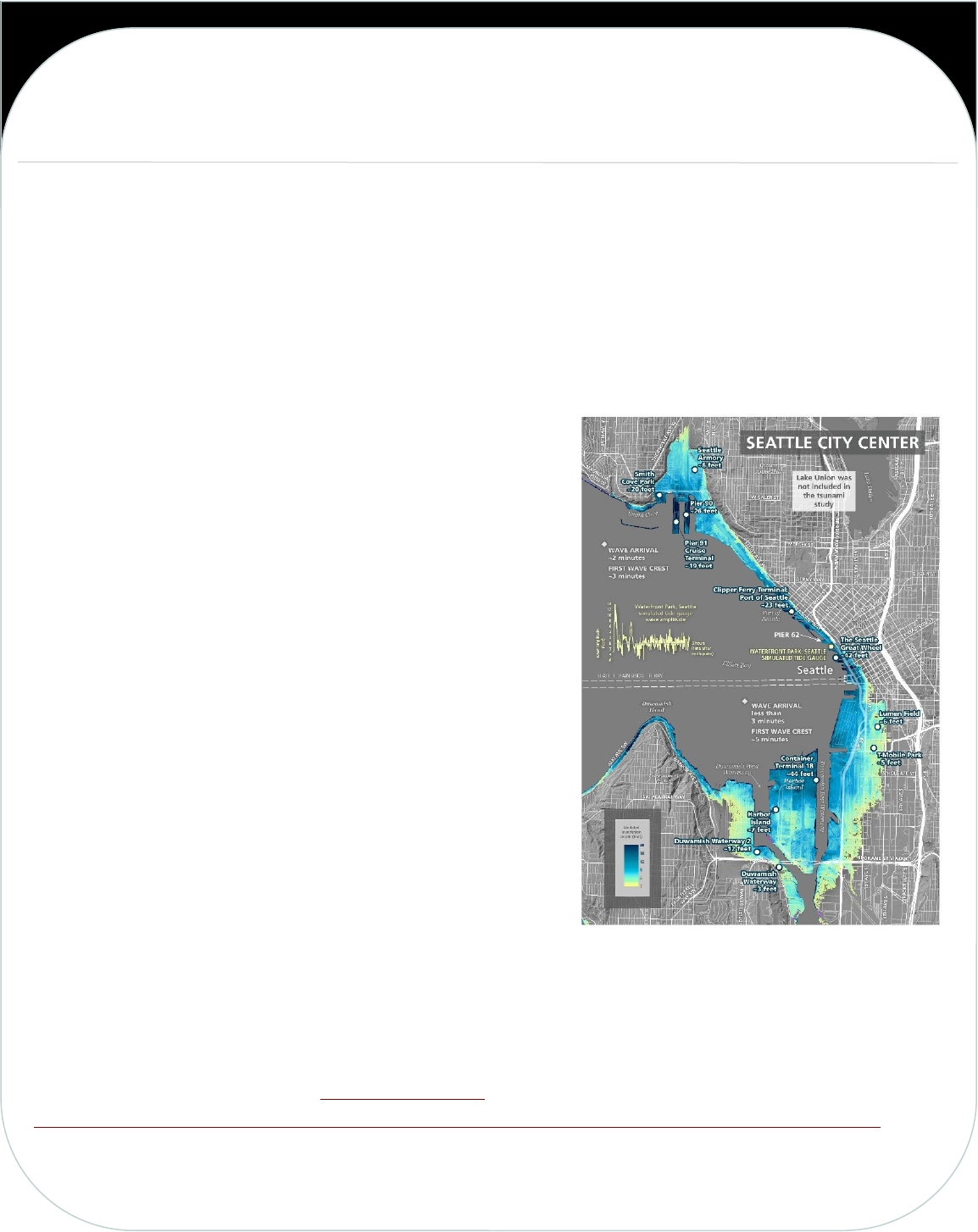
The Washington Geological Survey has released a new publication showing tsunami inundation, current speeds, and
arrival times from a large, low-probability Seattle Fault earthquake scenario. This publication includes 16 supplemental
map sheets covering Puget Sound and other parts of the Salish Sea, such as the Strait of Juan de Fuca, Rosario Strait, and
Strait of Georgia.
These are the first published tsunami hazard maps for many locations within this study area using a Seattle Fault zone
scenario. The onset of earthquake shaking may coincide with large changes in land elevations. For example, during the
earthquake areas north of the rupture subside while areas south of the rupture uplift. Our modeled earthquake scenario
matches the studied land level changes from the last Seattle Fault
earthquake that happened ~1,100 years ago; Restoration Point and
Alki Point uplifted as much as 23 and 14 feet, respectively, while
West Point subsided ~3 feet. This surface deformation is what
initiates the tsunami, which arrives in fewer than 3 minutes for the
communities within Elliott Bay, Seattle, the eastern side of
Bainbridge Island, among other locations. Modeling results show
inundation depths of ~20 feet or more along the shoreline of Elliott
Bay, Seattle and ~6 feet north of E 11th street, Port of Tacoma.
Estimated currents from the tsunami waves locally exceed 9 knots
(considered to be highly destructive) in many nearshore areas within
the central basin of Puget Sound and will be a major hazard to
boaters, the maritime industry, and port facilities. Tsunami wave
activity would likely continue over three hours and remain
hazardous to maritime operations for several hours after the
earthquake.
The results presented in this study are for a very large earthquake
that generates tsunami inundation that the next event is unlikely to
exceed. We did this to encourage emergency preparations for a
maximum-considered Seattle Fault scenario and increase community awareness within Washington’s inner waterways.
All tsunami hazard zones should be evacuated swiftly after the earthquake when safe to do so and any felt earthquake
shaking is an immediate warning of a potential tsunami. We recommend using this modeling as a tool to assist with
emergency planning prior to a Seattle Fault zone event.
This publication is available on our tsunami hazard maps webpage and downloadable using the following hyperlink:
https://fortress.wa.gov/dnr/geologydata/tsunami_hazard_maps/ger_ms2022-03_tsunami_hazard_seattle_fault.zip.
TSUNAMI PREPAREDNESS
New Tsunami Hazard Maps for Puget Sound and other parts of
the Salish Sea from a Large Seattle Fault Scenario
By the Washington Geological Survey
14
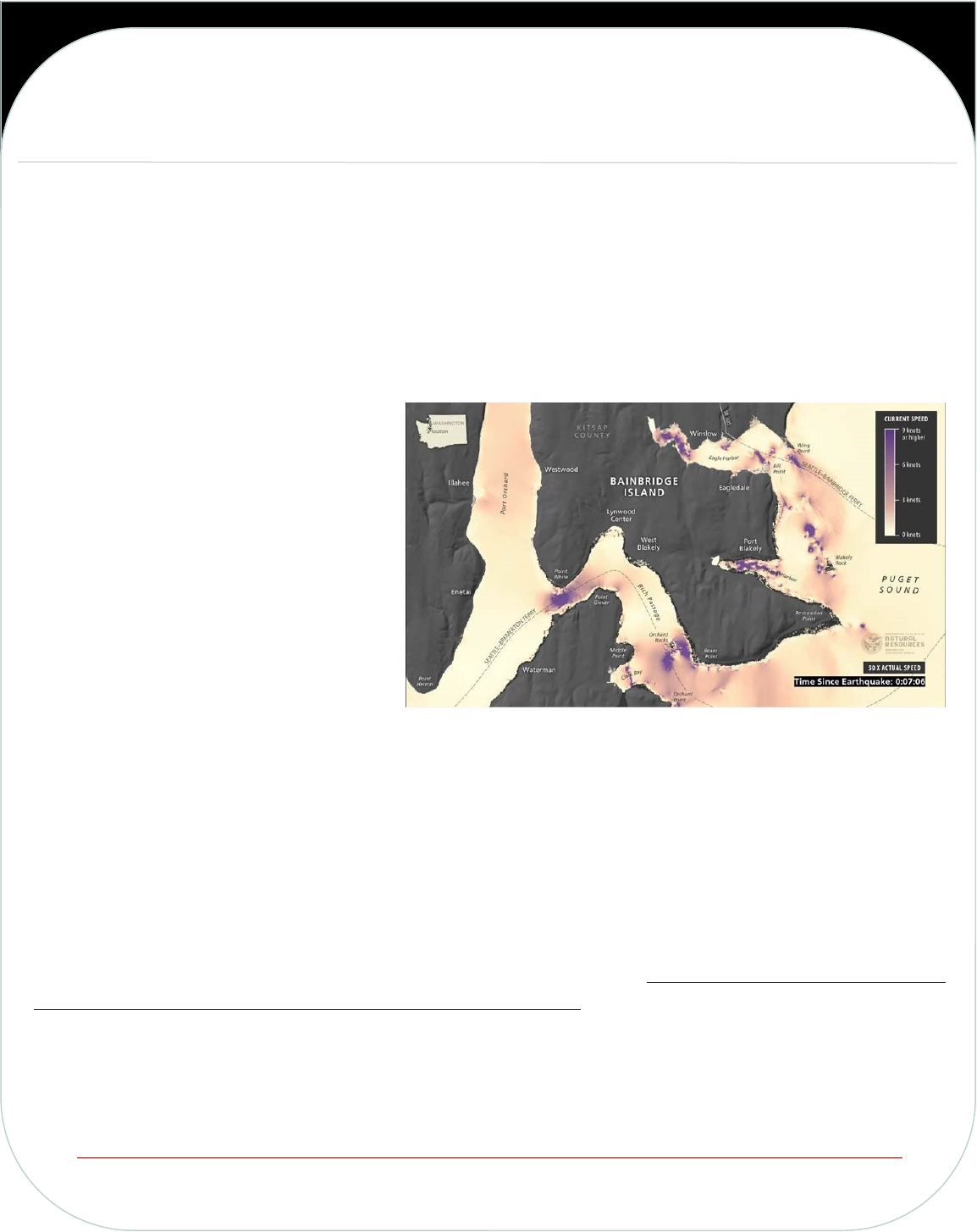
The Washington Geological Survey has released new videos showing simulated wave amplitude (wave peaks and
troughs), inundation (extent and depth of tsunami flooding over land), and current velocity (wave speed), for
communities in central Puget Sound.
Tsunamis are multi-wave events that affect coastal areas for many hours to potentially days after an earthquake happens.
To show how tsunamis might affect a certain area over time we use computer models to simulate how tsunami waves
might behave for a given earthquake scenario. Videos of tsunami simulations show tsunami wave behavior in a way that
is difficult to convey through static images and maps. Following the public release of these videos, we have received
many instances of positive correspondence
from community members demonstrating
increased awareness of tsunami hazards.
These new videos represent a tsunami that
might occur following a large earthquake on
the Seattle Fault. The next earthquake to
happen on the Seattle Fault may cause tsunami
wave action that varies from the results shown
in these simulations.
The videos demonstrate estimated tsunami
wave arrival times following the earthquake
and either detailed, localized tsunami amplitude and inundation or current velocity (wave speed) for the coastal areas
along Central Puget Sound, including the Seattle-Bainbridge waterfront, and southern Bainbridge Island and portions of
the Kitsap Peninsula. Each video is sped up to show the wave action of the tsunami over a period of several modeled
hours in minutes.
In the videos, for areas over bodies of water, wave amplitude is shown over a range from 10 feet or lower (for wave
troughs) to 10 feet or higher (for wave peaks). For areas over land, tsunami inundation is shown from a range of 0 feet
to 10 feet or higher. Additionally, wave speeds are shown in nautical miles per hour (knots). One knot is about 1.2 miles
per hour. These simulations use the model results from the Puget Sound and other parts of the Salish Sea tsunami
inundation and current velocity publication that came out in 2022: https://fortress.wa.gov/dnr/geologydata/
tsunami_hazard_maps/ger_ms2022-03_tsunami_hazard_seattle_fault.zip.
For more detailed tsunami information in your area, refer to our tsunami hazard maps. Note that these videos are for
informational purposes only and should not be used for site-specific decision-making. You can find the videos and
additional information about the simulations on our tsunami webpage:
https://www.dnr.wa.gov/programs-and-services/geology/geologic-hazards/tsunamis#tsunami-simulation-videos
TSUNAMI PREPAREDNESS
New Tsunami Simulation Videos Published in
Washington State for Central Puget Sound
By the Washington Geological Survey
15
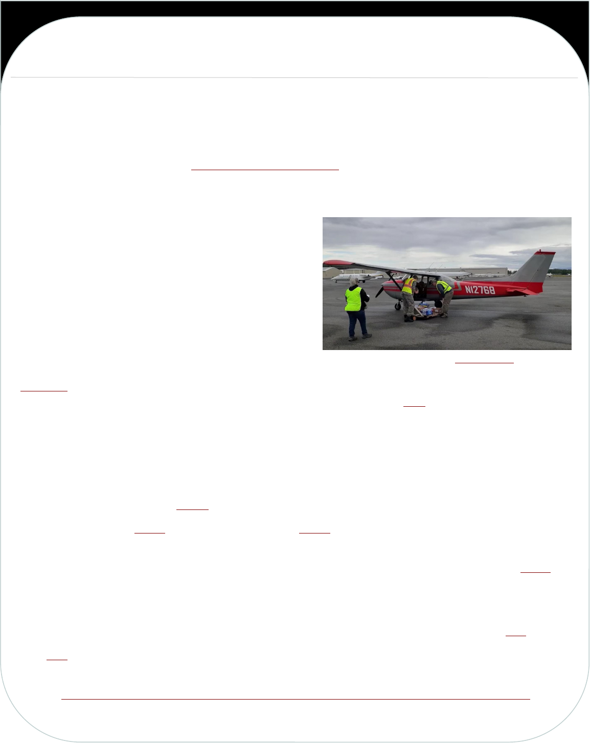
A June 18, 2022, test of how general aviation could help in the aftermath of a devastating earthquake in the Pacific
Northwest proved successful.
Called Thunder Run, the day-long drill “was truly a major step forward for GA and the West Coast General Aviation
Response Plan (WCGARP) and a huge success in very inclement weather,” reported Sky Terry, Northwest Regional
Emergency Services Director for the Emergency Volunteer Air Corps (EVAC).
“It’s been over a decade in the making, but we’ve truly built a response network that will be there in our darkest hour
to make that life-saving difference,” he said, noting the annual drills have been held for the past 11 years.
He explained that while general aviation is willing to step up in
an emergency, it’s important to train for such events.
To make the event even better, the drill included general
aviation pilots flying food to food banks around the region.
During the drill, 57 general aviation pilots from Washington,
Oregon, and Canada flew food to multiple food banks in
Washington and Oregon, Terry said.
By The Numbers
BC AERO, a Canadian group that organizes pilots and ground support in the aftermath of natural disasters, flew 12,869
pounds of food with 12 pilots flying 31 flights into Bellingham International Airport (KBLI).
That food was combined with a local food drive that ran for about a month and half prior to June 18 that collected
another 4,019 pounds of food. Some of that food was flown to other parts of the area, while the Miracle Food Network
received 1,127 pounds and Bellingham Food Bank received 1,261 pounds.
KBLI had around 100 arrivals during the day related to the drill.
At Walla Walla Regional Airport (KALW), 24,000 pounds of fresh produce was delivered by land by Farmer Frog.
A $5,000 donation from Serena and a $2,500 donation from AvFuel were combined to buy food from the Safeway store
in Walla Walla for the effort.
Pilots flying from Walla Walla were able to get 5,700 pounds of food flown to Renton Municipal Airport (KRNT) “in
spite of some truly nasty weather over much of the state,” Terry reported.
The rest was donated to the food bank system in Walla Walla.
You can read more about the annual drill in our story, “General aviation preps for when the big one hits” here.
Click here to watch of video of one general aviation pilot’s flights during the day.
Link to original article:
https://generalaviationnews.com/2022/06/27/general-aviation-pilots-drill-in-preparation-for-the-big-one/
Volunteers load food into Ginger The Plane during the drill.
TSUNAMI PREPAREDNESS
General Aviation Pilots Drill in Preparation for the Big One
By General Aviation News Staff
16
Biguenet, M.; Chaumillon, E.; Sabatier, P.; et al, 2022, Discriminating between tsunamis and
tropical cyclones in the sedimentary record using X-ray tomography: Marine Geology, v.
450, no. 106864. https://doi.org/10.1016/j.margeo.2022.106864
Brodsky, E. E.; Lay, Thorne, 2022, The wave blown around the world: Science, no. 377, no.
6601, p. 30-31. https://doi.org/10.1126/science.abq5392
Giles, Daniel; Gailler, Audrey; Dias, Frédéric, 2022, Automated Approaches for Capturing
Localized Tsunami Response—Application to the French Coastlines: Journal of Geophysical
Research Oceans, v. 127, no. 6, article e2022JC018467.
https://doi.org/10.1029/2022JC018467
Lane, E. M., 2022, Atmospheric waves reinforced tsunami after Tongan eruption: Nature, 08
August 2022. https://doi.org/10.1038/d41586-022-01855-0
Mori, Nobuhito; Satake, Kenji; Cox, Daniel; Goda, Katsuichiro; et al, 2022, Giant tsunami
monitoring, early warning and hazard assessment: Nature Reviews Earth & Environment,
August 23, 2022. https://doi.org/10.1038/s43017-022-00327-3
Tanigawa, Koichiro; Sawai, Yuki; Bobrowsky, Peter; et al, 2022, A new chronology for tsunami
deposits prior to the 1700 CE Cascadia earthquake from Vancouver Island, Canada:
Scientific Reports, 12, article 12527. https://doi.org/10.1038/s41598-022-16842-8
Wang, Yuchen; Imai, Kentaro; Kusumoto, Satoshi; Takahashi, Narumi, 2022, Tsunami Early
Warning of the Hunga Volcanic Eruption Using an Ocean Floor Observation Network Off
the Japanese Islands: Seismological Research Letters, 11 p.
https://doi.org/10.1785/0220220098
TSUNAMI RESEARCH & EVENTS
RESEARCH
UPCOMING NTHMP & RELATED EVENTS
September 12-17, 2022—AEG Annual Meeting (Las Vegas, NV) https://www.aegannualmeeting.org/
October 9-12, 2022— Geological Society of America (Denver, CO)
https://community.geosociety.org/gsa2022/home
November 5, 2022—World Tsunami Awareness Day https://tsunamiday.undrr.org/
December 12-16, 2022—AGU Fall Meeting (Chicago, IL) https://www.agu.org/fall-meeting
January 23-27, 2023—NTHMP Winter Meeting (Location TBD)
https://nws.weather.gov/nthmp/index.html
