
ZONING ORDINANCE
OF THE
TOWN OF PLYMOUTH,
NEW HAMPSHIRE
Originally Adopted: September 9, 1961
Last Amended: March 12, 2024
$10.00

ZONING ORDINANCE
OF THE TOWN OF PLYMOUTH,
NEW HAMPSHIRE
Index
ARTICLE I: AUTHORITY, PURPOSE & TITLE ..................................................................................................... 1
Section 101 Authority and Purpose ........................................................................................ 1
Section 102 Title ..................................................................................................................... 1
Section 103 Obligation to Comply .......................................................................................... 1
ARTICLE II: DEFINITIONS ................................................................................................................................ 1
Section 201 Word Definitions ................................................................................................. 1
Section 202 Term Definitions .................................................................................................. 2
ARTICLE III: ZONES, MAPS AND REGULATIONS ........................................................................................... 12
Section 301 Zones ................................................................................................................. 12
Section 302 Zoning Map ....................................................................................................... 12
Section 303 District Boundaries ............................................................................................ 12
Section 304 Zone Objectives and Land-Use Controls ........................................................... 13
ARTICLE IV: GENERAL PROVISIONS ............................................................................................................. 18
Section 401 Lots and Yards ................................................................................................... 18
Section 402 Height Regulations and Exceptions .................................................................. 19
Section 403 Temporary Uses and Structures ....................................................................... 19
Section 404 Abandonment of Structures ............................................................................. 20
Section 405 Non-Conforming Lots, Uses, and Structures ..................................................... 20
Section 406 Lots in Two Zones .............................................................................................. 22
Section 407 General Nuisance .............................................................................................. 22
Section 408 Signs .................................................................................................................. 22
Section 409 Accessory Building or Use ................................................................................. 29
Section 410 Essential Services .............................................................................................. 30
Section 411 Off-Street Parking ............................................................................................ 30
Section 412 Home Occupation ............................................................................................. 33
Section 413 Continuing Care Retirement Community (CCRC) .............................................. 33
Section 414 Fences ............................................................................................................... 34
Section 415 Sexually Oriented Businesses ............................................................................ 34
Section 416 Accessory Dwelling Unit (ADU) ........................................................................ 34
ARTICLE V: OPEN-SPACE RESIDENTIAL DEVELOPMENT ............................................................................... 36

Section 501 Applicability....................................................................................................... 36
ARTICLE VI: INDUSTRIAL PARK..................................................................................................................... 36
Section 601 Objectives ......................................................................................................... 36
Section 602 Permit to Build .................................................................................................. 36
ARTICLE VII: FLOODPLAIN DEVELOPMENT .................................................................................................. 36
Section 701 General Provisions ............................................................................................ 36
Section 702 Definition of Terms ............................................................................................ 37
Section 703 Permits Required ............................................................................................... 39
Section 704 Review of Building Permit Applications ............................................................ 40
Section 705 New or Replaced Water and Sewer Systems .................................................... 40
Section 706 Plans and Certification Following Construction ................................................ 40
Section 707 Other Government Permits .............................................................................. 40
Section 708 Riverine Situations ............................................................................................ 40
Section 709 Special Flood Hazard Areas ............................................................................... 41
Section 710 Environmentally-Sensitive Zone ........................................................................ 42
Section 711 Appeals and Variances ...................................................................................... 43
ARTICLE VIII: AIRPORT OVERLAY ZONE........................................................................................................ 43
Section 801 Purpose and Public Interest .............................................................................. 43
Section 802 Airport Zones .................................................................................................... 44
Section 803 Airport Zone Height Limitations ........................................................................ 44
Section 804 Use Restrictions ................................................................................................ 45
Section 805 Nonconforming Uses ......................................................................................... 45
Section 806 Land Use Permits .............................................................................................. 46
ARTICLE IX: PERSONAL WIRELESS SERVICE FACILITIES ................................................................................ 47
Section 901 Purpose ............................................................................................................. 47
Section 902 Definitions Specific to Personal Wireless Service Facilities ............................... 48
Section 903 Location ............................................................................................................. 49
Section 904 Use Regulations ................................................................................................. 49
Section 905 Design Standards .............................................................................................. 50
Section 906 Monitoring and Maintenance ........................................................................... 52
Section 907 Abandonment or Discontinuation of Use ......................................................... 52
ARTICLE X: IMPACT FEES ............................................................................................................................. 53
Section 1001 Authority and Purpose .................................................................................... 53
Section 1002 Definitions ....................................................................................................... 53
Section 1003 Administration ................................................................................................ 54

Section 1004 Assessment and Determination of Impact Fee ............................................... 54
Section 1005 Assessment Handling and Collection of Impact Fees ..................................... 54
Section 1006 On-Site Improvements .................................................................................... 55
Section 1007 Waivers ........................................................................................................... 55
Section 1008 Effective Date .................................................................................................. 55
ARTICLE XI: ADMINISTRATION AND ENFORCEMENT .................................................................................. 55
Section 1101 Administrative Official ..................................................................................... 55
Section 1102 Building Regulations ........................................................................................ 56
ARTICLE XII: BOARD OF ADJUSTMENT ........................................................................................................ 59
Section 1201 Creation of the Board of Adjustment ............................................................. 59
Section 1202 Membership of the Board of Adjustment ....................................................... 59
Section 1203 Rules of the Board of Adjustment .................................................................. 59
Section 1204 Duties of the Board of Adjustment ................................................................. 59
Section 1206 Rehearing and Appeal Procedures .................................................................. 64
ARTICLE XIII: MISCELLANEOUS PROVISIONS ............................................................................................... 64
Section 1301 Saving Clause .................................................................................................. 64
Section 1302 Amendments .................................................................................................. 64
Section 1303 Effective Date .................................................................................................. 65
ARTICLE XIV: ZONE BOUNDARY DESCRIPTIONS .......................................................................................... 65
Section 1401 Single-Family Residential ................................................................................ 65
Section 1402 Multi-Family Residential .................................................................................... 65
Section 1403 Civic/Institutional ............................................................................................ 66
Section 1404 Village Commercial ......................................................................................... 67
Section 1405 Highway Commercial ...................................................................................... 67
Section 1406 Industrial and Commercial Development ....................................................... 67
Section 1407 Agricultural ..................................................................................................... 67
APPENDICES
(Visual representation of zones and airport overlay may be enlarged when viewed online at
www.plymouth-nh.org)
A-I Airport Approach Plan
A-II Airport Overlay
A-III Color Map of Zones

PLYMOUTH, NH ZONING ORDINANCE - MARCH 12, 2024
Page 1
ZONING ORDINANCE
OF THE TOWN OF PLYMOUTH, NEW HAMPSHIRE
ARTICLE I: AUTHORITY, PURPOSE & TITLE
Section 101 Authority and Purpose
Pursuant to the authority, conferred by RSA Title LXIV, New Hampshire revised Statues Annotated 1984,
the purposes of this Ordinance are declared to be the protection and promotion of the health, safety,
and general welfare of the community. The zoning regulations and districts are in accordance with the
Plymouth Master Plan and are designed: to preserve Plymouth's small town atmosphere and attractive
natural setting; to guide development and growth while protecting areas such as wetlands, natural
habitats, agricultural lands, historic/cultural resources, aquifers and river quality; to strive to mitigate
environmental impacts associated with development and growth; to lessen congestion in the streets, to
secure safety from fire, panic and other dangers, to avoid undue concentration of population, to
promote good civic design and arrangements, to protect the value of homes and land, to facilitate the
wise expenditure of public funds and to ensure adequate provision of transportation, water, sewerage,
schools, parks and other public requirements. This Ordinance is created giving full consideration to the
natural capability of the land to sustain development and to community goals.
Section 102 Title
This Ordinance shall be known and cited as the “Zoning Ordinance of the Town of Plymouth, New
Hampshire.”
Section 103 Obligation to Comply
It is the continued obligation of all owners, tenants, occupants and persons in possession of property to
comply with, and to assure that use of property complies with, all terms of this Ordinance. Any such
persons who violate this Ordinance or who knowingly permit violation of this Ordinance to occur on
property owned or controlled by them shall be subject to an enforcement action under Section 1102.11
and to penalties for violation for violation imposed by Section 1101.2 and New Hampshire statute,
including but not limited to RSA Chapter 676.
ARTICLE II: DEFINITIONS
For the purpose of this Ordinance, certain terms or words used herein shall be interpreted as follows. In
addition, as to Article VII, Floodplain Development, the terms used therein but not defined below shall
be interpreted as set forth in Chapter X, Title 24 of the Code of Federal Regulations, Section 1909.1.
Section 201 Word Definitions
The word PERSON includes a firm, association, organization, partnership, trust, company or corporation
as well as an individual. The present tense includes the future tense, the singular number includes the
plural, and the plural number includes the singular. The word SHALL or WILL is mandatory, the word MAY
is permissive. The Planning Board hereby incorporates by reference the definitions of the following
terms contained in RSA chapter 672. The Board intends to utilize the text of these definitions as they

PLYMOUTH, NH ZONING ORDINANCE - MARCH 12, 2024
Page 2
may be subsequently amended, to the extent possible: “Abutter” (RSA 672:3), “Street” (RSA 672:13) and
“Subdivision” (RSA 672:14).
Section 202 Term Definitions
ADULT ARCADE: Any place to which the public is permitted or invited wherein coin-operated or slug-
operated or electronically, electrically, or mechanically-controlled still or motion picture machines,
projectors, or other image producing devices are maintained to show images to five (5) or fewer persons
per machine at any one time, and where the images so displayed are distinguished or characterized by
the depicting or describing of “specific sexual activities” or “specified anatomical areas.”
ADULT BOOKSTORE OR ADULT VIDEO STORE: An establishment, which, as one of the principal business
purposes, offers for sale, rental, or any other form of consideration any one of the following:
a) Books, magazines, periodicals or other printed matter, photographs, films, motion pictures,
video cassettes, or other video reproductions, slides, computer software, or other visual
representations which depict or describe “specified sexual activities” or “specified anatomical
areas.”
b) Instruments, devices, or paraphernalia, which are designed for use in conjunction with “specified
sexual activities.”
ADULT CABARET: A nightclub, or restaurant, or similar commercial establishment, or a private
membership, fraternal membership, or social club, which during a substantial portion of the total
presentation time features:
a) Live performances, which are characterized by the exposure of “specified anatomical areas” or
by “specified sexual activities.”
b) Films, motion pictures, video cassettes, or other video reproductions, slides, computer software,
or other visual representations which depict or describe “specified sexual activities” or
“specified anatomical areas.”
ADULT THEATER: A theater, concert hall, auditorium, or similar place of public assembly which features
persons who appear in a state of nudity or live performances in which a substantial portion of the total
presentation time is devoted to the showing of material which are characterized by the exposure of
“specified anatomical areas” or by “specified sexual activities.”
AGRICULTURE: Use of land for farming, dairying, pasturing, floriculture, horticulture, forestry, and/or
animal and poultry husbandry.
AIRPORT: Plymouth Municipal Airport.
AIRPORT ELEVATION: The highest point of an airport's usable landing area measured in feet from sea
level.
APPROACH SURFACE: A surface longitudinally centered on the extended runway centerline, extending
outward and upward from the end of the primary surface and at the same slope as the approach zone
height limitation slope set forth in Section 803 of this Ordinance. In plan the perimeter of the approach
surface coincides with the perimeter of the approach zone.
APPROACH, TRANSITIONAL, HORIZONTAL AND CONICAL ZONES: These zones are set forth in Section 802
of this Ordinance.
AREA OF SHALLOW FLOODING: (see Article VII Floodplain Development Section 702).
AREA OF SPECIAL FLOOD HAZARD: (see Article VII Floodplain Development Section 702).

PLYMOUTH, NH ZONING ORDINANCE - MARCH 12, 2024
Page 3
ATTACHED DWELLING UNIT: A dwelling unit separated from other dwelling units by party walls but
where no portion of a dwelling unit extends over a portion of another.
AUTO SERVICE STATION: Any area of land, including structures thereon, that is used or designed to be
used for the supply of gasoline or oil or other fuel for the propulsion of motor vehicles and/or does
mechanical repairs and which may include facilities used or designed to be used for polishing, greasing,
washing, spraying, or otherwise cleaning or servicing such motor vehicles. A service station is not a sales
or major repair agency for autos, trucks, or trailers.
BANK: A financial institution that is open to the public, with or without a drive-up window, for the
custody, loan, or exchange of money; for the extension of credit and for facilitating the transmission of
funds.
BAR/TAVERN/NIGHTCLUB: A retail establishment that primarily engages in preparing and serving
alcoholic beverages for on-premise consumption. These establishments may also provide limited food
services. If more than 50% of the establishment's gross receipts (as determined by the State Liquor
Commission) are from the sale of alcoholic beverages, then the establishment will be considered a bar or
tavern as opposed to a restaurant (see definition of restaurant). (Adopted 3/10/89, by Warrant Article)
BASE FLOOD: (see Article VII Floodplain Development Section 702).
BASEMENT: (see Article VII Floodplain Development Section 702).
BED & BREAKFAST: A transient lodging facility that is the personal residence of its owner and is
occupied by the owner at the time of rental to a patron in which the only meal served is breakfast to in-
house guests. A bed and breakfast shall have no more than four (4) rentable rooms in the residence and
have an area of dining capable of accommodating the number of registered guests whose posted room
rates shall include breakfast.
BREAKAWAY WALL: (see Article VII Floodplain Development Section 702).
BUFFER: An area of land used to separate visibly one use from another or which acts as a separation
between two land uses of different intensity.
BUILDINGS: A constructed unit forming a shelter for persons, animals, or property and having a roof and
being permanently located on the land. Where the context allows, this word “building” shall be
construed as though followed by the words “or part thereof” (also see Article VII Floodplain
Development Section 702).
CAMPING TRAILER: A non-self-propelled structure mounted on wheels, requiring for occupancy the
unfolding or erection of parts, and designed for travel, recreation, and vacation use.
CEMETERY: Land used for the burial of deceased humans or cremated human remains which is dedicated
for cemetery purposes.
CHILDCARE CENTER: A building or structure where care, protection and supervision are provided, on a
regular schedule, at least twice a week to four or more children, unrelated to the operator or caregiver. A
childcare center does not include an occupied residence where childcare is provided as a home
occupation.
CHURCH: A place for worship and related religious functions, not for habitation.
CIVIC USES: Uses by agencies and departments of local, county, state and federal governments. The type
of function of the governmental facility is stated below:
OFFICE: Includes such functions as government office, laboratory, post office, clinic, assembly,

PLYMOUTH, NH ZONING ORDINANCE - MARCH 12, 2024
Page 4
and court.
EDUCATION: Includes such functions as elementary, middle, junior high and high schools, college,
vocational or technical schools, kindergarten, library, and similar educational institutions.
INSTITUTION: Governmental and other facilities primarily engaged in public services such as
education, health and research.
PUBLIC SAFETY: Includes such functions as fire, police, rescue, and ambulance services.
SERVICE: Includes such functions as garage, warehouse, vehicular repairs, outside storage for
vehicles and supplies, and similar uses.
RECREATION: Includes such functions as recreation center, senior citizen’s center, gymnasiums,
auditorium, and outdoor recreation facilities such as play fields, tennis courts and golf courses.
REFUSE DISPOSAL: Includes areas of structures for disposal of sewage, solid waste and garbage
under the control of a governmental unit, including sanitary landfills, incinerators, sewage treatment
plants and similar methods of disposal.
CEMETERY: Includes such functions as cemetery, cemetery vaults and necessary maintenance
structures.
PARKING: Includes but is not limited to, municipally owned parking facilities, available for use by the
general public.
COMMERCIAL SERVICE: A business which provides or sells a service rather than a product such as, but
not limited to, barber, hairdresser, beauty parlor, shoe repair, shoe shine, dry cleaner, or photographic
studio.
COMMON OPEN SPACE: Land within an open-space residential development, not individually owned,
which is designed and intended for the common use or enjoyment of the residents of the development,
or the public, which may contain such accessory structures and improvements as are necessary and
appropriate for recreational purposes. A condition of the open-space residential development approval
shall be that common open space may not be further subdivided.
COMPLYING STRUCTURE: A complying structure means a structure or part thereof that is in compliance
with the Zoning Ordinance covering building bulk, dimensions, height, area, yards, density or off-street
parking or loading requirements.
CONDOMINIUM: A multi-unit property, each of whose residents enjoy exclusive use of their individual
unit and retains an undivided interest in common elements.
CONFORMING USE: A use, which occupies a building or land that does conform to the use regulations of
the zone in which it is located.
CONICAL SURFACE: A surface extending outward and upward from the periphery of the horizontal
surface at a slope of 20 to 1 for a horizontal distance of 4,000 feet.
CONTINUING CARE RETIREMENT COMMUNITY (CCRC): A residential community for the elderly, which
includes a contract for lifetime residency. A CCRC may have common facilities, including but not limited
to licensed intermediate and skilled nursing facilities primarily for and adequate to meet the needs of
the residents, and other services, which are not accessory to other, permitted uses. The community and
all of its facilities shall be under one ownership.
DEVELOPABLE LAND: The developable land area is that portion of the tract remaining after deducting the
undevelopable land area (such as wetland and steep slopes) from the total tract area.

PLYMOUTH, NH ZONING ORDINANCE - MARCH 12, 2024
Page 5
DEVELOPMENT: (see Article VII Floodplain Development Section 702).
DRIVE-THROUGH SERVICE: A service that by design, physical facilities, or packaging procedures
encourages or permits customers to receive services or obtain goods while remaining in their motor
vehicles.
DWELLING: Any building or part thereof that is designed or used for non-transient residential purposes.
ACCESSORY DWELLING UNIT: An “accessory dwelling unit” (or “ADU”) is a residential living unit that
is within, attached to or detached from a single-family dwelling, and that provides independent
living facilities for one or more persons (but no more than two adults per ADU), including provisions
for sleeping, eating, cooking and sanitation on the same parcel of land as the principal dwelling unit
it accompanies. The ADU shall be approved by the issuance of a Conditional Use Permit which meets
the criteria of the zoning ordinance and planning review. Every accessory dwelling unit shall be
deemed a resident of workforce housing for purposes of satisfying the municipality’s obligation
under RSA 674:59.
DWELLING, SINGLE-FAMILY: A detached residential dwelling unit other than manufactured housing,
designed for and occupied by one family only.
DWELLING, SINGLE-FAMILY ATTACHED: A dwelling unit that occupies a structure from ground to roof
and is physically connected to another dwelling unit by at least one common wall extending from the
foundation through the roof, and each dwelling unit has an independent, private entrance front and
rear entrance.
DWELLING, TWO-FAMILY: A residential building designed for or occupied by two families living
independently of each other in individual dwelling units, each with a separate entrance.
DWELLING, MULTIFAMILY: A residential building designed for or occupied by three to six families,
with the number of families in residence not exceeding the number of dwelling units provided.
DWELLING UNIT: One room, or rooms connected together, constituting a separate, independent
housekeeping establishment for owner occupancy, rental or lease, and physically separated from any
other rooms or dwelling units which may be in the same structure, and containing independent
cooking, sanitary and sleeping facilities. It shall not include motel, hotel, tourist home, rooming
house, or similar structures.
EDUCATION: Includes such functions as elementary, middle, junior high and high schools, college,
vocational or technical schools, kindergarten, library, and similar educational institutions.
ESSENTIAL SERVICES: The distribution or transmission of public utilities. Essential service shall include
but not be limited to wires, drains, sewers, and conduits. Essential services shall not include wireless
communication facilities.
FAMILY, RELATED: Any number of persons related by blood or by marriage or adoption living together as
a single housekeeping unit.
FAMILY, UNRELATED: Any group of 3 persons or less not related by blood, marriage nor adoption living
together as a single housekeeping unit. In determining the maximum number of persons, the children of
any resident shall not be counted.
F.E.M.A.: (see Article VII Floodplain Development Section 702)
FENCE: An enclosure or barrier constructed of wood, masonry, stone, wire, metal, or other
manufactured material or combination of materials erected as a boundary or to enclose, screen, or
separate areas.

PLYMOUTH, NH ZONING ORDINANCE - MARCH 12, 2024
Page 6
FLOOD OR FLOODING: (see Article VII Floodplain Development Section 702).
FLOOD BOUNDARY AND FLOODWAY MAP: (see Article VII Floodplain Development Section 702).
FLOOD ELEVATION STUDY: (see Article VII Floodplain Development Section 702).
FLOOD INSURANCE RATE MAP (FIRM): (see Article VII Floodplain Development Section 702).
FLOODPLAIN or FLOOD-PRONE AREA: (see Article VII Floodplain Development Section 702).
FLOOD PROOFING: (see Article VII Floodplain Development Section 702).
FLOODWAY: (see Article VII Floodplain Development Section 702).
FLOOR AREA, GROSS: The sum of the areas of the several floors of main and accessory building(s) on a
lot, as measured by exterior faces of the walls, and of enclosed porches as measured by exterior limits
thereof, but excluding the areas of unroofed and/or unenclosed porches or terraces, basements or attics
used only for accessory storage or service, and accessory buildings used for garage purposes.
FORESTRY: Forestry is the growth and harvesting and processing of forest products.
FRONTAGE: The width of a lot measured along its common boundary with the street line.
FUEL STORAGE: Gasoline fuels, propane, oil or oil derivatives or by-products of more than 1,000 gallons.
FUNCTIONALLY DEPENDENT USE: (see Article VII Floodplain Development Section 702).
FUNERAL HOME (MORTUARY, FUNERAL PARLOR): Pursuant to RSA 325, a place or premise devoted to or
used in the care and preparation for the funeral and burial of dead human bodies or maintained for the
convenience of the bereaved for viewing or other services in connection with dead human bodies or as
an office or place for carrying on the profession of funeral directing.
HAZARD TO AIR NAVIGATION: An obstruction determined to have a substantial adverse effect on the safe
and efficient utilization of the navigable airspace.
HEALTH CARE FACILITY: A facility or institution, whether public or private, principally engaged in
providing services for health maintenance, diagnosis or treatment of human diseases, pain, injury,
deformity, or physical condition, including but not limited to a general hospital, diagnostic center,
treatment center, rehabilitation center, extended care center, nursing home, intermediate care facility,
outpatient laboratory, or central services facility serving one or more such institutions.
AMBULATORY SURGICAL FACILITY: means a health care facility or a portion of a health care facility
which provides surgical treatment to patients not requiring hospitalization, and does not include the
offices of private physicians or dentists, whether in individual or group practices
HOSPITAL: An institution which is engaged in providing to patients, under supervision of physicians,
diagnostic and therapeutic services for medical diagnosis, treatment, and care of injured, disabled,
or sick persons, or rehabilitation services for the rehabilitation of such persons. The term “hospital”
includes psychiatric and substance abuse treatment hospitals.
CLINIC, MEDICAL OR DENTAL: A facility operated by one or more physicians, dentists, chiropractors
or other licensed practitioners of the healing arts for the examination and treatment of persons
solely on an outpatient basis
NURSING HOME: Means a place which shall provide, for 2 or more persons, basic domiciliary
services (board, room, and laundry), continuing health supervision under competent professional
medical and nursing direction, and continuous nursing care as may be individually required

PLYMOUTH, NH ZONING ORDINANCE - MARCH 12, 2024
Page 7
CONTINUING CARE RETIREMENT COMMUNITY (CCRC) A residential community for the elderly, which
includes a contract for lifetime residency. A CCRC may have common facilities, including but not
limited to licensed intermediate and skilled nursing facilities primarily for and adequate to meet the
needs of the residents, and other services, which are not accessory to other, permitted uses. The
community and all of its facilities shall be under one ownership
HEIGHT: For the purpose of determining the height limits in all zones set forth in this Ordinance and
shown on the zoning map, the datum shall be mean sea level elevation unless otherwise specified.
HIGHEST ADJACENT GRADE: (see Article VII Floodplain Development Section 702).
HISTORIC STRUCTURE: (see Article VII Floodplain Development Section 702).
HOME OCCUPATION: Any use that is conducted from or within a residential dwelling unit and is clearly
incidental and secondary to the use of the building as a residential dwelling and does not change the
residential character thereof. (see Section 412).
HOMEOWNER'S ASSOCIATION: A private nonprofit association which is organized by the developer of an
open space residential development in which individual owners share common interests in open space
and/or facilities and are in charge of preserving, managing and maintaining the common property, and
enforces certain covenants and restrictions.
HORIZONTAL SURFACE: A horizontal plane 150 feet above the established airport elevation, the
perimeter of which in plan coincides with the perimeter of the horizontal zone.
HOSPITAL: Includes sanitarium, clinic, nursing home, convalescent home, and any other place for the
diagnosis, treatment or care of human ailments.
HOTEL: A building or group of building which contain four or more apartments or living accommodations
for ten or more persons, with or without kitchens, and which constitute primarily the temporary abode
of persons who have their residence elsewhere. This shall include motel and hotel.
INDUSTRY: The assembly, manufacture, processing, packaging or other operations to goods or materials.
HOME OCCUPATIONS are excluded.
INSTITUTION: Facilities primarily engaged in public services including, but not limited to, education,
research, health and public worship.
JUNKYARD: Any yard or field used for the storage or old metals, old bottles, solid textile mill waste,
unfinished cloth, old paper products, old rubber products, old plastic products, two or more
unregistered motor vehicles which are unfit for use on highways, used parts and materials of motor
vehicles and other second hand or waste articles.
LABORATORY RESEARCH: Laboratory for use as a commercial, scientific, or research laboratory of a non-
nuisance and non-hazardous character.
LOT: A lot is a parcel of land.
LOT AREA: The horizontal area of the lot lying within the lot lines, exclusive of any area in a street and
any fresh water.
LOT, CORNER: A lot situated at the intersection of, and abutting two streets, which have an angle of
intersection of not more than 135 degrees. A lot abutting on a curved street shall be deemed a corner
lot if the tangents to the curve at its points of intersection with the side lot lines meet at the interior
angle of NOT MORE than 135 degrees.
LOWEST FLOOR: (see Article VII Floodplain Development Section 702).

PLYMOUTH, NH ZONING ORDINANCE - MARCH 12, 2024
Page 8
LUMBERYARD (HOME IMPROVEMENT CENTER): A facility where building materials such as lumber,
plywood, drywall, paneling, cement blocks and other cement products, and other building products are
stored and sold. Lumberyards may also process lumber by performing millwork, planing, cutting, and
other customizing processes. Lumberyards may provide for the sale of associated products including
tools and fasteners.
MANUFACTURED HOUSING: Any structure, transportable in one or more sections, which, in the traveling
mode, is eight (8) body feet or more in width and 40 body feet or more in length, or when erected on
site, is 320 square feet or more, and which is built on a permanent chassis and designed to be used as a
dwelling unit with or without a permanent foundation when connected to required utilities, which
include plumbing, heating and electrical systems contained therein. Manufactured housing as defined in
this section shall not include pre-site built housing as defined in RSA 674:31-a. (see Article VII Floodplain
Development Section 702).
MANUFACTURED HOUSING PARK: Any tract of land, portions of which are leased or rented, on which
three or more manufactured houses are parked and occupied for living purposes.
MANUFACTURE OF GOODS SOLD ON PREMISES: The transformation of materials or substances into new
products, including the assembling of component parts, the manufacturing of products, and the
blending of materials, where the product is sold solely on-site. Examples include bakery, print shop, etc.
MEAN SEA LEVEL: (see Article VII Floodplain Development Section 702).
METHADONE TREATMENT CLINIC/FACILITY: Methadone treatment facility means any property licensed
facility, other than a hospital, where the drug methadone is administered or dispensed to patients for
the purposes of opiate addiction treatment.
MOTOR HOME: A portable, temporary dwelling to be used for travel, recreation, and vacation,
constructed as an integral part of a self-propelled vehicle.
NON-COMPLYING STRUCTURE: A non-complying structure means a structure or part thereof not in
compliance with the Zoning Ordinance covering building bulk, dimensions, height, area, yards, density,
off-street parking or loading requirements.
NON-CONFORMING USE: A use, building or land which was legal at the effective date of this Ordinance
or amendments thereto that does not conform to the use regulations of the zone in which it is located.
NOXIOUS USE: Any use that would be harmful, injurious, or unhealthy.
OFFICE: A room, suite of rooms, or building in which a person transacts the affairs of a business,
profession, service, industry, or government.
100-YEAR FLOOD: (see Article VII Floodplain Development Section 702).
OPEN-SPACE RESIDENTIAL DEVELOPMENT: A form of residential subdivision provided for in Article V of
this Ordinance and in the Plymouth Subdivision Regulations, authorizing dwelling units to be located on
sites or lots within a single tract with dimensions, frontages, and setbacks reduced from conventional
sizes, provided the density of the tract as a whole shall not be greater than the density allowed by the
zone under existing regulations and the remaining open land is devoted to common open space except
in exchange for certain “density bonus” options approved by the Planning Board.
PARKING SPACE, OFF-STREET: For the purpose of this Ordinance, an off-street parking space shall consist
of a space with dimensions nine (9) feet by nineteen (19) feet exclusive of properly related access to a
public street or alley and maneuvering room and shall meet all requirements as imposed by this
Ordinance.

PLYMOUTH, NH ZONING ORDINANCE - MARCH 12, 2024
Page 9
PARKING FACILITY: Required off-street parking areas for three or more automobiles.
PARKING FACILITY, OFF-SITE: Off-street parking area on land other than the related use.
PERSON: An individual, firm, partnership, corporation, company, association, joint stock association, or
governmental entity; includes a trustee, a receiver, an assignee, or a similar representative of any of
them.
PICKUP COACHES (CAMPERS): A constructed unit designed primarily to be mounted on a pickup or truck
chassis and with sufficient equipment to render it suitable for use as a temporary dwelling for travel,
recreational, and vacation purposes.
PLAT: A map showing proposed layout of streets and/or lots to scale.
PRIVATE CLUB (PRIVATE LODGE): Structures, facilities and grounds owned or operated by a private or
fraternal organization for use by its members and guests.
PROPERTY OWNER: The owner of record.
PRIMARY SURFACE: A surface longitudinally centered on a runway. When the runway has a specially
prepared hard surface, the primary surface extends 200 feet beyond each end of that runway or when
the runway has no specially prepared hard surface, or planned hard surface, the primary surface ends at
each end of that runway. The width of the primary surface is set forth in Section 802 of this Ordinance.
The elevation at any point on the primary surface is the same as the elevation of the nearest point on
the runway centerline.
PRINCIPAL BUSINESS PURPOSE: A principal business purpose shall be deemed to exist, for the purpose of
regulating sexually-oriented businesses, if ten percent (10%) or more of the gross floor area of a business
is devoted to the sale, display, depiction, or expression of “specified sexual activities,” “specified
anatomical areas,” or instruments, devices, or paraphernalia which are designed for use in connection
with “specified sexual activities.”
PUBLIC STREET: A vehicular traveled way which the town or state has the duty to maintain regularly. A
Class V or better highway.
RECREATION, INDOOR: Indoor recreation activities shall include but not be limited to bowling, tennis,
squash, racquetball, ice skating, roller skating, billiards, and video games.
RECREATION, OUTDOOR: Outdoor recreation activities which shall include but not be limited to such
facilities as outdoor tennis courts, swimming pool, golf courses, play fields, and similar uses. No buildings
shall be allowed except for the necessary related uses such as restrooms and maintenance facilities. In
all cases, any building shall be treated as a Special Exception.
RECREATIONAL VEHICLE: (see Article VII Floodplain Development Section 702).
REGULATORY FLOODWAY: (see Article VII Floodplain Development Section 702).
RESIDENTIAL INSTITUTION: Residential institution shall include home for the elderly, orphanage, rest
home, extended care facility, and similar types of group living accommodations that provide services for
the residents in a congregate fashion such as but not limited to common meals and health care.
RESIDENTIAL USE: Includes single-family dwelling, two-family dwelling, multiple-unit dwelling, and
manufactured housing.
RESTAURANT: A retail establishment where food and drink are prepared, served and consumed primarily
within the principal building; and where no ordering and pick up of food takes place from a motor
vehicle. Restaurants include cafeterias, lunchrooms, fast food restaurants (without drive-through service)

PLYMOUTH, NH ZONING ORDINANCE - MARCH 12, 2024
Page 10
and similar establishments, and establishments that meet the definition of a restaurant as specified in
RSA 175:1 LIX. (Adopted by Warrant Article 3/10/09).
RETAIL SALES: Include shop and store for the sale of retail goods, personal service shop and department
store, and shall exclude any drive-in service, free-standing retail stand, gasoline service and motor
vehicle repair services, new and used car sales and service, trailer and mobile home sales and service
and commercial services.
ROOMING HOUSE: Any residential dwelling (other than a hotel or motel) in which living
accommodations without individual kitchen facilities are rented to at least five but not more than 16
non-transient guests. A boarding or lodging house shall be deemed a rooming house.
RUNWAY: A defined area on an airport prepared for landing and take off of aircraft along its length.
SEXUAL CONDUCT SUBSTANTIAL PORTION OF THE TOTAL PRESENTATION TIME: Occurring no more than
seven (7) days within a fifty-six (56) consecutive day period.
SEXUALLY ORIENTED BUSINESS: An adult arcade, adult bookstore or video store, adult cabaret, adult
motion picture theater or adult theater.
SIGN: Any device, structure, fixture or placard using graphics, symbols, and/or written copy designed
specifically for the purpose of advertising or identifying any establishment, product, goods, or service.
For the purposes of this Ordinance the word “sign” does not include the flag, pennant, or insignia or any
nation, group of nations, state, city, or other governmental units. See Section 408.
SPECIAL EXCEPTION: A use of a building or lot which may not otherwise be permitted under this
Ordinance except upon application to the Board of Adjustment and subject to the approval of that
Board, and only in cases where the words “special exception” on this Ordinance pertain, and in
accordance with the provisions of Article XII, Board of Adjustment.
SPECIAL FLOOD HAZARD AREA: (see Article VII Floodplain Development Section 702).
SPECIFIED ANATOMICAL AREA: Human genitals and anus, female breasts.
SPECIFIED SEXUAL ACTIVITIES: Means and includes any of the following:
a) Human masturbation, sexual intercourse, oral copulation or sodomy, actual simulated, whether
alone or between members of the same or opposite sex or between humans and animals.
b) Fondling or erotic touching of human genitals, anus, pubic region, buttocks, or female breasts.
c) Excretory functions, flagellation or torture as part of or in conjunction with any of the activities
set forth in a. and b. above.
STREET LINE: Right-of-way line of a street as dedicated by a deed of record. Where the width of the
street is not established, the street line shall be considered to be twenty-five (25) feet from the
centerline of the street pavement.
STRUCTURE, ACCESSORY: Anything constructed or erected with a fixed location on the ground, which is
subordinate to and detached from but located on the same lot as the principal structure, the use of
which is customarily incidental and secondary to that of the principal structure. Accessory structures
shall include, but not be limited to, pools and shed.
STRUCTURE, PRINCIPAL: Anything constructed or erected with a fixed location on the ground where the
primary use of the lot is conducted.
SUBSTANTIAL DAMAGE: (see Article VII Floodplain Development Section 702).

PLYMOUTH, NH ZONING ORDINANCE - MARCH 12, 2024
Page 11
SUBSTANTIAL IMPROVEMENT: (see Article VII Floodplain Development Section 702).
THEATER: A building or part of a building devoted to showing motion pictures or for dramatic, dance,
musical, or other live performing arts. Such establishments may include related services such as food
and beverage sales and other concessions.
TRACT: An area, parcel, site, piece of land, or property, which is the subject of a development proposal
and application.
THEATER: A building or part of a building devoted to showing motion pictures or for dramatic, dance,
musical, or other live performing arts. Such establishments may include related services such as food
and beverage sales and other concessions
TOURIST HOME: A building, or part thereof, other than a motel or hotel, where sleeping
accommodations are provided for transient guests, with or without meals, and which also owner
occupied.
TRANSITIONAL SURFACES: These surfaces extend at 90-degree angles to the runway centerline and the
runway centerline extended at a slope of seven (7) feet horizontally for each foot vertically from the
sides of the primary and approach surfaces to where they intersect the horizontal and conical surfaces.
TRAVEL TRAILER: A vehicular, portable, non-self-propelled structure built on a chassis, designed to be
used as a temporary dwelling for travel, recreational, and vacation uses, having a body width not
exceeding 8 feet, and body length not exceeding 32 feet.
TREE: Any object of natural growth.
UNDEVELOPABLE LAND AREA: The undevelopable land area is that portion of the tract which is
comprised of wetlands, slopes in excess of 25% and land within the 75-foot building setback area of the
Environmentally Sensitive Zone as described in the Article VII, Floodplain Development.
USE, PERMITTED: Use specifically allowed in the district, excludes illegal uses and non-conforming uses.
UTILITY RUNWAY: A runway that is constructed for and intended to be used by propeller-driven aircraft
of 12,500 pounds maximum gross weight and less.
VARIANCE: Such departure from the terms of this Ordinance as the Board of Adjustment, upon appeal in
specific cases, is empowered to authorize under the terms of Article XII, Board of Adjustment, and
applicable statutes of the State of New Hampshire.
VEHICULAR SALES AND REPAIR: Storage and display for sale of more than two motor vehicles or any
type of trailer, provided the trailer is unoccupied, or where repair or body work are performed on motor
vehicles or trailers, including Auto Service Stations (see sect 411.2, parking requirements). Vehicle sales
include motor vehicle retail or wholesale sales.
VISUAL RUNWAY: A runway intended solely for the operation of aircraft using visual approach
procedures.
WATER SURFACE: (see Article VII Floodplain Development Section 702).
WETLANDS: Wetlands means an area that is inundated or saturated by surface water or groundwater at
a frequency and duration sufficient to support, and that under normal conditions does support, a
prevalence of vegetation typically adapted for life in saturated soil conditions. As adopted by reference
to RSA 48-A:2, X, which will incorporate any future Statute changes.
WHOLESALE BUSINESS: Includes warehouse, wholesale establishment, discount house, bulk storage, and
bulk sales outlet.

PLYMOUTH, NH ZONING ORDINANCE - MARCH 12, 2024
Page 12
YARD: Space on a lot not occupied with a building or structure.
YARD, FRONT OR SETBACK: Yard between the front lot line and the closest point of the structure. The
depth of the front yard shall be measured from the street line to the closest point of the structure.
YARD, REAR: Yard between the rear lot line and the closest point of the structure. The depth of the rear
yard shall be measured from the rear lot line to the closest point of the structure.
YARD, SIDE: Yard between the principal building or accessory building and a side lot line, and extending
through from the front yard to the rear yard.
ARTICLE III: ZONES, MAPS AND REGULATIONS
Section 301 Zones
The Town of Plymouth is divided into the following zones as shown on the official zoning map on file
with the Town Clerk.
SFR – Single-Family Residential
MFR – Multi-Family Residential
A – Agricultural
CI – Civic/Institutional
VC – Village Commercial
HC – Highway Commercial
ICD – Industrial and Commercial Development
F – Floodplain Development (overlay) (see Article VII Section 701)
ES – Environmentally Sensitive (overlay) (see Article VII Section 709)
AR – Airport (overlay) (see Article VIII)
Section 302 Zoning Map
The zones as established in Section 301 and described in Article XII are shown on the official zoning map
and the Flood Insurance Rate Map and Flood Boundary and Floodway maps, Town of Plymouth, New
Hampshire dated May 3, 1982 on file in the office of the Town Clerk. The Floodplain zone applies to any
land located in any other zone. The zoning map is contained in Appendix A. The revised Flood Insurance
Rate Maps (FIRM) and Flood Boundary and Floodway maps (PB/Fw) as shown in the State of New
Hampshire Department of Transportation FEMA Floodway Boundary Map Revision study for the town of
Plymouth and Holderness identified as I-93 improvements for exits 25 and 26 project numbers IM-93-
2(143)80; IM-93-2(145)80; and IM-93-2(147)80 dated January 1993 as prepared by Bettigole Andrews &
Clark, Inc. Consulting Engineers Concord, NH, when officially adopted by the Federal Emergency
Management Agency (FEMA), shall be incorporated into the official zoning map of the Town of
Plymouth. The dates of the maps so produced shall be inserted on the official incorporated into this
Ordinance where necessary.
Section 303 District Boundaries
A zone boundary shown on the zoning maps as approximately following the center line of a street, a
shoreline of a body of water, shall be construed as following such line. When zoning boundaries are
created using a specific distance from a street, the distance is measured from the closest edge of the
street right-of-way. If the zone classification of any land is in question, it shall be deemed to be in the
PLYMOUTH, NH ZONING ORDINANCE - MARCH 12, 2024
Page 13
most restricted adjoining zone.
Section 304 Zone Objectives and Land-Use Controls
The following subsection establishes the regulations that apply in each zone. Any use designed as a
“permitted use” may be commenced in the particular zone providing the standards established by this
Ordinance are met. Unless a variance, special exception or action on an appeal from the administrative
decision is required, the necessary permit may be issued by the Selectmen or their designee. Any use
designated as a “special exception” may be commenced in the particular district only after approval by
the Board of Adjustment. If a specific use is not listed, then it is not allowed unless the Planning Board
finds the use is sufficiently similar to an enumerated permitted or special exception use. General
provisions pertaining to all zones are described in Article IV. In the event of any conflict between
restrictions contained in Article VII, Floodplain Development and Article VIII, Airport and the restrictions
of any underlying zone, the more restrictive shall apply.
The following chart lists those uses allowed in each zone. Those uses designed with a “P” in the various
zones are permitted and allowed by right. Those uses designed “SE” are allowed only as a special
exception as granted by the Zoning Board of Adjustment. A dash indicates that the use is neither
permitted, nor allowed by special exception in the corresponding zone.
USES
ZONE
RESIDENTIAL
SFR
MFR
A
CI
VC
HC
ICD
Accessory Dwelling Unit
SE
P
P
P
P
P
P
Continuing Care Retirement Community
-
-
P
-
-
-
-
Manufactured Housing
-
-
P
-
SE
1
SE
SE
Multifamily Dwelling, not exceeding 6 units
per building
-
P
SE
SE
P
1
SE
SE
Open-Space Residential Development
**
P
P
P
P
P
1
SE
SE
Residential Institution
-
SE
SE
P
SE
1
P
P
Rooming House
-
SE
SE
SE
SE
1
SE
SE
Single-Family Dwelling, Detached
P
P
P
P
P
1
SE
SE
Single-Family Dwelling, Attached, not
exceeding 4 units per building
-
P
P
P
P
1
SE
SE
Two-Family Dwelling
SE
P
P
P
P
1
SE
SE
1
See Section 304.1
2
See Section 416
**
See Open-Space Residential Development section, Plymouth Subdivision Regulations
Uses
Zone
MUNICIPAL
SFR
MFR
A
CI
VC
HC
ICD
Civic Use
-
-
P
P
SE
SE
SE
PLYMOUTH, NH ZONING ORDINANCE - MARCH 12, 2024
Page 14
Civic Use limited to Public Safety
-
SE
P
P
SE
P
P
Civic Use limited to Public Safety and
Recreation
SE
-
P
P
SE
SE
SE
Civic Use limited to Office, Public Safety,
Recreation, Parking and Service
-
-
P
P
P
SE
SE
Uses
Zone
SFR
MFR
A
CI
VC
HC
ICD
Library
-
-
SE
P
SE
SE
SE
COMMERCIAL
Auto Service Station
-
-
P
-
P
P
P
Bank
-
-
P
P
P
P
P
Bar/Tavern/Nightclub
2
-
-
-
-
-
-
-
Childcare Center
SE
SE
P
P
P
P
SE
Commercial Service
-
-
P
SE
P
P
P
Drive-through Restaurant
-
-
P
-
-
P
P
Drive-through Service
-
-
P
-
SE
P
P
Fuel Storage
-
-
SE
-
SE
SE
SE
Funeral Establishment
-
-
SE
P
SE
SE
SE
Hotel/Motel
-
-
P
-
P
P
P
Outdoor Recreation
-
-
P
SE
SE
P
P
Indoor Recreation
-
-
P
-
P
P
P
Junkyard
-
-
SE
-
SE
SE
SE
Lumberyard
-
-
SE
-
SE
SE
SE
Office
-
SE
P
P
P
P
P
Personal Wireless Communication Facilities
P
3
P
3
P
3
P
3
P
3
P
3
P
3
Printing and Publishing
-
-
SE
-
SE
P
P
Private Club
-
-
SE
SE
P
P
P
Restaurant
-
-
P
SE
P
P
P
Retail Sales
-
-
P
SE
P
P
P
Sexually-Oriented Business (must meet
additional requirements of Section 415)
-
-
SE
-
-
-
-
Theater
-
-
P
P
P
P
P
Tourist Home
-
-
P
-
P
P
P
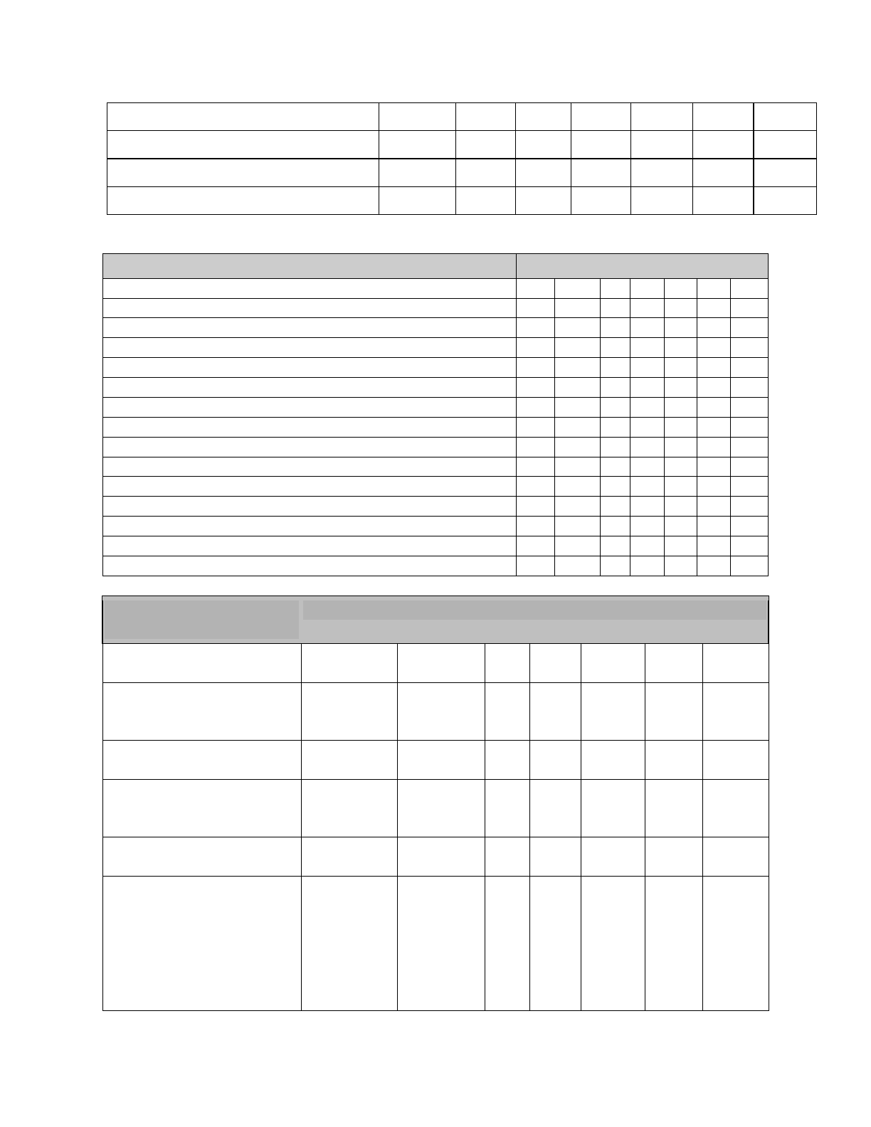
PLYMOUTH, NH ZONING ORDINANCE - MARCH 12, 2024
Page 15
Truck Terminal
-
-
SE
-
SE
SE
SE
Vehicular Sales and Repair
-
-
P
-
SE
P
P
Warehouse
-
-
SE
-
SE
SE
P
Wholesale Business
-
-
SE
-
SE
P
P
2
Adopted by Warrant Article 3/10/09
3
Allowed in all zones provided the provisions of Article IX are met
Uses
Zone
INSTITUTIONAL
SFR
MFR
A
CI
VC
HC
ICD
Church
-
-
P
P
P
P
P
Education
-
-
SE
P
SE
SE
SE
Hospital
-
-
SE
P
SE
SE
SE
Medical Center
-
-
SE
P
SE
SE
SE
Research Laboratory
-
-
SE
SE
SE
SE
SE
AGRICULTURAL
SFR
MFR
A
CI
VC
HC
ICD
Agriculture
-
-
P
-
SE
SE
SE
Forestry
-
-
P
-
SE
SE
SE
INDUSTRIAL
SFR
MFR
A
CI
VC
HC
ICD
Industry
-
-
SE
-
SE
SE
P
MISCELLANEOUS
SFR
MFR
A
CI
VC
HC
ICD
Accessory buildings in excess of three (3)
SE
SE
SE
SE
SE
SE
SE
Off-Site Parking Facility
-
SE
SE
SE
SE
SE
SE
Accessory structure in front, side or rear setback area
SE
SE
SE
SE
SE
SE
SE
Section 304 Area
Dimensions**
Zone
Minimum frontage (in feet)
for:
SFR
MFR
A
CI
VC
HC
ICD
-lots tied into a municipal or
private sewage disposal
system
75
75
100
100
50
100
100
-lots with on-site septic
disposal
100
100
100
100
50
150
150
-Backlots approved under
Article VIII, Section R of
Subdivision Regulations
50
50
50
50
50
50
50
Minimum yards (setbacks)
in feet
SFR
MFR
A
CI
VC
HC
ICD
-front
15, or the
average
front
setback of
all
residential
lots within
15, or the
average
front
setback of
all
residential
lots within
30
30
00
30
30
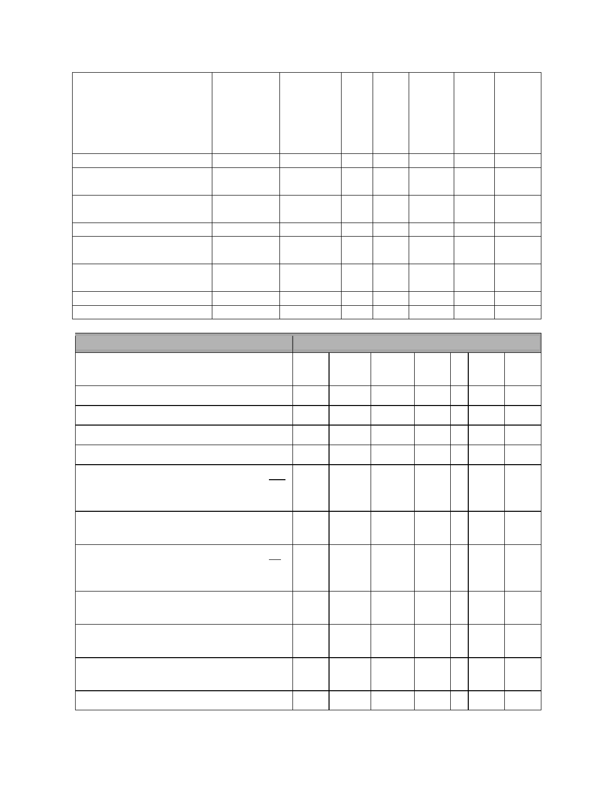
PLYMOUTH, NH ZONING ORDINANCE - MARCH 12, 2024
Page 16
Uses
Zone
Minimum yards (in feet) on Rented Lots in
Manufactured Housing Parks:
SFR
MFR
A
CI
VC
HC
ICD
-front
-
-
25
-
25
25
25
-side
-
-
12
-
12
12
12
-rear
-
-
12
-
12
12
12
Minimum lot area, in square feet
With municipal or private sewage disposal and
public water in accordance with appropriate
State standards
10,000
7,500
40,000
20,000
-
20,000
20,000
Additional minimum land area for each
dwelling unit over one
5,000
2,500
2,500
2,500
-
5,000
5,000
With municipal or private sewage disposal or
public water in accordance with appropriate
State standards
20,000
15,0000
40,0000
20,000
-
20,000
20,000
Additional minimum land for each
dwelling unit over one
5,000
2,500
2,500
2,500
-
5,000
5,000
With an on-site septic disposal system and
private water
43,560
43,560
43,560
43,560
0
43,560
43,560
Additional minimum land area for each
dwelling unit over one.
7,500
7,500
7,500
2,500
0
2,500
4,500
300,
whichever is
less, but no
less than 5
feet.
300,
whichever
is less, but
no less
than 10
feet.
-side
10
10
15
10
00
15
15
-rear
10
10
15
10
10 ft.
0 by SE
15
15
Maximum yards (setbacks)
in feet
SFR
MFR
A
CI
VC
HC
ICD
-front
N/A
N/A
N/A
N/A
10
N/A
N/A
Minimum Setback for
uncovered parking spaces
Front
See Sec.
411.3
See Sec.
411.3
15
15
15
15
15
Side
10, 5 by SE
10, 5 by SE
15
10
00
15
15
Rear
10, 5 by SE
10, 5 by SE
10
10
10
15
15
PLYMOUTH, NH ZONING ORDINANCE - MARCH 12, 2024
Page 17
** Lot area, frontage, setbacks, and coverage shall be in accordance with the Open-Space Residential
Development section of the Plymouth Subdivision Regulations.
SFR
MFR
A
CI
VC
HC
ICD
Maximum lot coverage by impervious surfaces (percentage of total lot
area):
75
75
75
75
100
75
75
304.1 Residential Use in Village Commercial Zone
In the Village Commercial Zone, residential uses are permitted above or below the street level only.
Residential uses on the street level are permitted only by special exception in accordance with Section
1204.2 and Section 1204.3
304.2 Reserved

PLYMOUTH, NH ZONING ORDINANCE - MARCH 12, 2024
Page 18
ARTICLE IV: GENERAL PROVISIONS
The following provisions shall apply to all zones except where listed:
Section 401 Lots and Yards
401.1 Multiple Buildings on a Single Lot
A. More than one principal structure shall be permitted on a lot provided that all other applicable zoning
requirements are met, and:
1. Interior setbacks, access, and circulation between buildings shall meet life/safety minimums as
determined by the Plymouth Fire Department, and
2. Except for detached single-family and two-family dwellings, all main structures shall be subject
to Site Plan Review, including their relationship to the shared amenities and stormwater
drainage.
B. The Planning Board may grant a conditional Use Permit for the Placement of more than one single-
family or two-family dwelling on a lot, provided that:
1. For the proposed number of dwelling units, the lot meets the minimum lot area requirements
under Section 304, Area Dimensions;
2. Interior setbacks, access, and circulation between buildings shall meet Life/Safety minimums as
determined by the Plymouth Fire Department;
3. There shall be a landscaped buffer along the full length of any lot line abutting an existing single-
family dwelling and internal landscaping providing for orderly separations between dwellings and
one or more landscaped walkways providing connectivity within the site;
4. The applicant provides for adequate water supply and for sewage disposal service in compliance
with RSA 485-A:38 and regulations adopted by the New Hampshire Department of Environmental
Services;
5. There shall be not more than one curb cut from the street unless required for Life/Safety
minimums by the Plymouth Fire Department;
6. There shall be sufficient off-street parking on the lot for each dwelling unit to comply with the
minimum parking requirements for single-family or two-family homes under Section 411; and
7. The proposed co-location of single-family and two-family dwellings is not an Open Space
Residential Development (OSRD) under Article V. Any proposal for an OSRD shall be review and
approval by the Planning Board under Article IX of the Plymouth Subdivision Regulations.
401.2 Existing Lots of Record
A building may be constructed on any lot of record in any zone in accordance with Section 405.
401.3 Minimum Lot Frontage
For any main use the minimum lot frontage shall be as specified in Section 304, except that lots in open
space developments or lots on cul-de-sacs may be those specified in Section 504.
401.4 Yard Regulations
a) Any lot line contiguous to a street is deemed to be a front line; a lot fronting on any two streets
shall be deemed to have two front lot lines and two side lot lines; a lot fronting on three streets
shall be deemed to have three front lot lines and one side lot line for the purpose of determining
setback.
b) Notwithstanding provisions for front yards elsewhere in these regulations, on streets with less

PLYMOUTH, NH ZONING ORDINANCE - MARCH 12, 2024
Page 19
than 50-foot rights-of-way, the front yard requirement shall be measured from the center line of
the existing roadway and 25 feet shall be added to the front yard requirement.
c) No structure may occupy any part of a required front yard, side yard or rear yard.
401.5 Building Coverage, Open Porches, Carports, and Garages
In determining the percentage of building coverage of a lot or the size of yards, porches or carports open
at the sides but roofed, and all principal and accessory buildings shall be included.
401.6 Reduction of Lot Area
No lot shall be so reduced in area that the area, yards, lot width, frontage, coverage or other
requirements of these regulations shall be smaller than herein prescribed for each district. The
provisions of this section shall not apply when part of a lot is taken for public purposes.
401.7 Required Area of Yards
Space required under these regulations to satisfy area, yard or other open space requirements in
relation to one building shall not be counted as part of a required open space for any other building.
401.8 Location of Driveways
All driveways are to be located at least seventy-five feet from a street line intersection for all uses.
401.9 Corner Lots
Lots, which abut on more than one street, shall provide the required frontage along every street.
401.10 Minimum Lot Size
For any use, the minimum lot size specified in each zone, except Village Commercial, shall be the same
as the minimum lot size specified for one dwelling unit in Section 304.
Section 402 Height Regulations and Exceptions
a) The height of any building shall not be greater than 35 feet as measured from the average
finished grade of the land surrounding the structure.
i. Except that, for any lot in the Village Commercial zoning district with frontage on Main
Street, the maximum height of any building shall not be greater than 35’, as measured from
the average elevation of Main Street along said frontage.
b) Flagpoles located on a roof or in any required yard may extend above the height limit.
c) Chimneys, spires, towers, stage houses, lightning rods, or like superstructures not used for
human occupancy may extend above the height limit located on a structure of main use.
Freestanding chimneys or towers may be permitted only as a Special Exception by the Board of
Adjustment.
d) Radio or TV antenna for private, non-commercial reception may be located on the roof or in the
rear yard of a structure of main use, but not in the required front yard.
Section 403 Temporary Uses and Structures
403.1 No recreational vehicle or tent, as defined by RSA 216-I:1, may be used as a permanent dwelling
at any time except in accordance with the provisions of Section 403.2.
403.2 Temporary permits may be issued by the Selectmen for a period not exceeding one year for uses
incidental to construction projects, provided such permits are conditioned upon agreement by

PLYMOUTH, NH ZONING ORDINANCE - MARCH 12, 2024
Page 20
the owner to remove such structure or use upon expiration of the permit. Such permits may be
renewed upon application for an additional period of one year as long as construction is active.
These uses shall be limited to manufactured homes, trailers, or portable structures used for
residential, office, storage, and locker purposes, provided that proper sanitary facilities, as
defined by RSA 216-1:4, are available.
403.3 The Building Inspector may issue a permit for any property owner or tenant to accommodate
themselves or nonpaying guests to reside on the property in no more than two recreational
vehicles or tents, as defined by RSA 216-I:1, for a period not exceeding 120 days in any one
calendar year provided that proper sanitary facilities, as defined by RSA 216-I:4, are available;
the requirements of Section 709 Special Flood Hazard Areas are met; and all applicable life safety
codes are met.
403.4 A property owner or tenant may store unoccupied recreational vehicles which they own
provided that the recreation vehicles meet the requirements of Section 709 Special Flood Hazard
Areas; are not connected to any utilities; are not used for storage, shelter, or human habitation;
and they do not create a junkyard.
Section 404 Abandonment of Structures
404.1 Within six months after work on an excavation for a building has begun, the excavation thus
remaining shall be covered (such as with building construction) or filled to normal grade by the owner.
404.2 Within six months after a permanent or temporary building or structure has been
destroyed, demolished or abandoned, all structural materials shall be removed from the site, and the
excavation thus remaining shall be covered over (such as with building construction) or filled to the
normal grade by the owner.
404.3 Further, no construction in process of completion or demolition and no ruins from fire or
other casualty shall be abandoned. Such structure shall be considered to have been abandoned when
work to remedy the improper condition shall not have been initiated within 90 days after the occasion of
the casualty, or if the initiated work shall have been discontinued with the owner's consent for 30 or
more consecutive days or for more than 30 days out of 60 days. Each day's abandonment shall be
considered as a separate violation of the Ordinance. The above periods of time may be extended by the
Board of Adjustment, upon application of the owner, for good cause shown.
Section 405 Non-Conforming Lots, Uses, and Structures
The purpose of this section of the ordinance is to regulate nonconforming lots, uses, and structures;
provide limitations on their use; and clarify under what circumstances nonconforming lots, uses, and
structures may be expanded, reduced, modified, continued, or terminated.
405.1 Nonconforming Lots: A lot that has less than the prescribed minimum area or frontage, may be
built upon provided that all other regulations of this ordinance are met and that lot, before the adoption
of the requirements which have made it nonconforming, and meets the following requirements:
a) was lawfully laid out by plan or deed duly recorded in the Grafton County Registry of Deeds; or
b) was shown on a subdivision plan approved before September 15, 1971 under the Subdivision
Regulations, Town of Plymouth, NH; or

PLYMOUTH, NH ZONING ORDINANCE - MARCH 12, 2024
Page 21
c) was otherwise exempt from such regulations by the provisions of statute, and provided that
such lot conforms to the area and frontage requirement of the Zoning Ordinance applicable at
the time of said recording or approval.
Lots merged by municipal action for zoning, assessing or taxation purposes prior to the effective date of
this ordinance and without the consent of the property owner, as determined by the Select Board, shall
not be deemed to have been merged for the purposes of this Zoning Ordinance, the Town’s Subdivision
Regulations, or Site Plan Review Regulations.
Changes to frontage of lots or setbacks through boundary line adjustments may be made provided that
the changes do not result in increasing the amount of nonconformity and all provisions of the
Subdivision Regulations, Town of Plymouth, NH are followed.
405.2 Nonconforming Uses: If a lawful use exists at the effective date of adoption or amendment of this
ordinance, which would not be allowed in the zone under the terms of this ordinance, said use shall be
protected and may be continued so long as it remains otherwise lawful and subject to the other
provisions of this section. If a nonconforming use is discontinued for one (1) year or superseded by a
conforming use, it shall thereafter conform to the regulations of the zone and the nonconforming use
may not be resumed.
405.3 Nonconforming Structures: Structures that lawfully existed prior to the enactment of any
ordinance which made them unlawful shall be called nonconforming structures and may remain as long
as they are maintained in a safe and occupiable condition.
405.3.1 Repairs to Nonconforming Structures - Nothing in this section shall prevent the ordinary repair
and maintenance of any lawfully established, nonconforming structure.
405.3.2 Destruction, Demolition - A nonconforming structure, which has been destroyed partly or
completely, may be rebuilt within the following limitations:
a) Size - The nonconforming area of a rebuilt structure shall not exceed the dimensional size of the
original building footprint.
b) Location - The rebuilt structure shall be repositioned to the greatest extent possible in
conformance with front, side and rear setbacks. However, this is not intended to prohibit a
property owner from reusing a foundation remaining after destruction or demolition or
permitting a new foundation to be built in the same location of a demolished foundation.
405.3.3 Alterations - No alterations shall be made to a nonconforming structure which make the
structure more nonconforming except as follows:
PLYMOUTH, NH ZONING ORDINANCE - MARCH 12, 2024
Page 22
a. Additions – Horizontal or lateral additions may be
made to any nonconforming structure if the
addition itself is conforming to the standard
requirements of the Zoning Ordinance. For
additions to residential structures that are
nonconforming in terms of the front setback, the
following shall apply:
i) Additions that follow the existing building line
and do not extend closer to the property line
than the existing building will require a Special
Exception (Addition #1 on the diagram).
ii) Additions encroaching further into the front
setback will require a Variance (Addition #2 on
the diagram).
iii) Additions within the setback area are permitted
(Addition #3 on the diagram).
Section 406 Lots in Two Zones
A. Where a zone boundary line divides a lot of record at the time such line is adopted, the lot
shall conform to the regulations for the more restricted zone, provided the lot has frontage
on a street in the more restricted zone.
B. Where a zone boundary line divides a lot at the time such line is adopted, the regulations for
the less restricted part of such lot shall not extend more than thirty feet (one hundred feet in
rural districts) into the more restricted part, provided the lot has frontage on a street in the
less restricted zone.
Section 407 General Nuisance
No person shall allow, cause to be allowed, nor permit any use of land within the boundaries of the Town
of Plymouth to be used in any manner that would be considered noxious use of said land.
Section 408 Signs
408.1 Purpose
The purpose of this article is to regulate the erection of signs for the purposes of protecting public safety.
These regulations allow for the presentation of information and advertising in an orderly, effective,
aesthetic and safe manner. Restrictions on type, number, location and size of signs protect the public
from hazardous and distracting displays, maximize traffic safety, and create an attractive environment,
which is conducive to business, industry, and tourism. Further, the purpose of this article is also to
preserve scenic vistas, discourage development from competing with the natural environment, to
promote the character of the town as a rural and historic community, and to protect residential areas
from intrusive commercial activity. These purposes are consistent with the goals of the Town’s Master
Plan.
408.2 Definitions
BANNER: A sign made of fabric or any nonrigid material with no enclosing framework.
BILLBOARD: A non-point-of-sale or off-premise sign, which advertises a business, organization, event,

PLYMOUTH, NH ZONING ORDINANCE - MARCH 12, 2024
Page 23
person, place or thing.
BULLETIN BOARD: Any sign erected for purposes or announcing events or providing other public
information, and contains no commercial message.
CANOPY: A rigid or retractable roof-like structure supported by and extending from the facade of a
building or a freestanding roof-like structure including fixed and/or retractable window, doorway or
walkway awnings.
CHANGEABLE COPY: A sign that is designed so that characters, letter, or illustrations can be changed or
rearranged either manually in the field (e.g. reader boards with changeable letters) or automatically on a
lamp bank or through mechanical means (e.g. electrical or electronic time and temperature units)
without altering the face or the surface of the sign.
CONSTRUCTION SIGNS: A temporary sign identifying an architect, contractor, lender and/or material
supplier participating in construction on the property on which the sign is located.
DIRECTIONAL SIGNS: Those signs located at the point of access/egress directing traffic into and out of
the site.
DISPLAY AREA: The display surface (copy area) encompassed within any regular geometric figure, which
would enclose all parts of the sign. On a freestanding sign, such area shall be calculated as the maximum
projected area of the sign. If any sign is designed so that any portion of the supporting structure is an
integral part of the message or advertisement conveyed by the sign, the display area shall be deemed to
include such portion of the supporting structure.
FLAGS: Official flags of governmental jurisdictions, including flags indicating weather conditions and
flags, which are emblems of on-premises organizations.
FREESTANDING SIGN: A sign supported upon the ground by poles or braces and not attached to any
building.
IDENTIFICATION SIGN: A sign whose copy is limited to the commercial name and address of a building,
institution, or person and/or to the activity or occupation being identified.
LEGAL NON-CONFORMING SIGN: (1) a sign which was erected legally but which does not comply with
subsequently enacted sign restriction and regulations; (2) a sign which does not conform to the sign
Ordinance requirements, but for which a special permit has been issued.
NAMEPLATE: A nonelectric on-premise residential identification sign giving only the name, address,
and/or occupation of an occupant or group of occupants.
NONACCESSORY SIGN: Any sign that does not advertise the name, address, business, and/or products of
the site on which the sign is located.
PENNANT: Any lightweight plastic, fabric, or other materials, whether or not containing a message of any
kind, suspended from a rope, wire, or string, usually in series, designed to move in the wind.
PORTABLE SIGN: Any sign not permanently attached to the ground or other permanent structure, or a
sign designed to be transported, including, but not limited to, signs designed to be transported by means
of wheels; balloons or other gas-filled figures used as signs; sidewalk or curb signs; and signs attached to
or painted on vehicles parked and visible from the public right-of-way, unless said vehicle is licensed,
registered and inspected, and regularly and customarily used to transport persons or property for the
business.
POSTER: Any temporary, non-durable sign, whether handmade or professionally printed, that advertises

PLYMOUTH, NH ZONING ORDINANCE - MARCH 12, 2024
Page 24
a name, business, service, event, and/or product.
PROJECTING SIGN: A sign, other than a flat wall sign, which is attached to and projects from a building
wall or other structure not specifically designed to support the sign.
REAL ESTATE SIGN: A temporary sign advertising the real estate upon which the sign is located as being
for rent, lease or sale.
ROOF SIGN: Any sign erected over or on the roof of a building
ROTATING SIGN: A sign in which the sign itself or any portion of the sign moves in a revolving or similar
manner. Such motion does not refer to methods of changing copy.
SIGN: Any device, structure, fixture, or placard using graphics, symbols, and/or written copy designed
specifically for the purpose of advertising or identifying any establishment, product, goods, or service.
For the purposes of this Ordinance the word “sign” does not include the flag, pennant, or insignia or any
nation, group of nations, state, city, or other governmental unit.
TEMPORARY SIGN: A sign not constructed or intended for long-term use.
WALL SIGN: A sign painted on or attached to and erected parallel to the face of, or erected and confined
within the limits of the outside wall of any building and supported by such wall or building and which
displays only one advertising surface.
408.3 Prohibited Signs and Materials
The following types of signs are expressly prohibited in all districts unless otherwise provided for in this
article.
a) Animated, moving, flashing, or intensely lighted signs and signs that emit sound, or visible
matter (e.g. smoke, bubbles, water).
b) Portable signs except as provided in Section 408.5 D. No vehicle, including parts thereof (e.g.
trailers and other accessories) shall be used as a sign except for a licensed, registered and
inspected vehicle that is regularly and customarily used to transport persons or property.
c) Signs located on public property or over or across any public street or right-of-way, or which
block from view any traffic or street sign or traffic signal. Special permission for such signs may
be granted by the Board of Selectman where a public benefit can be associated.
d) Searchlights and rotating signs.
e) Signs which imitate, and may be confused with, an official traffic control sign or signal, or an
emergency or road equipment vehicle.
f) A fence or any wall that is not structurally a part of a building may not be used for a sign except
to identify a residence or a residential structure.
g) In accordance with RSA 236:75, it shall be unlawful to affix, attach, or display any advertisement
upon any object of nature, utility pole, telephone booth, or highway sign.
h) Signs or any advertising material affixed to any public property including, but not limited to,
trash receptacles.
i) As reflected in the purpose of the Sign Ordinance (Section 408.1), in order to reflect an attractive
environment, all signs in the Village Commercial Zone, excluding window signs, must be made
from or resemble materials such as wood, metal, stone, or cloth and may be painted.
408.4 Signs Permitted by Special Exception
The following types of signs are allowed by Special Exception in accordance with the following table and
subject to the requirements of Section 408.5
PLYMOUTH, NH ZONING ORDINANCE - MARCH 12, 2024
Page 25
SIGN TYPE
ZONING DISTRICT
HC, ICD, A
VC
CI, SFR, MFR
Billboard and non-accessory signs
Special Exception
Not permitted
Not permitted
Roof signs
Special Exception
Not permitted
Not permitted
Internally illuminated signs, not
including neon signs
Permitted
Not permitted
Not permitted
Second entry sign
n/a
1 additional wall or
projecting sign per business
at business entry not facing
a street, maximum 8 square
feet and 10 feet in height
n/a
Existing nonconforming sign
n/a
A nonconforming sign shall
lose its nonconforming
status and sha
ll be removed
in the event that the signed
business ceases to operate
at that location for any
period of time.
408.5 Permitted Signs
The following signs are allowed with a duly authorized Sign Permit.
a) Signs are permitted within all districts in accordance with the following table and as restricted by
the following subparagraphs.
PLYMOUTH, NH ZONING ORDINANCE - MARCH 12, 2024
Page 26
Projecting Signs
Use canopy of projecting signs, not both...
Maximum number per business
1
1
n/a
Maximum number per lot
n/a
n/a
1
Maximum advertising display area
8 square feet
8 square feet
1 square foot
Maximum projection
6'
6'
2'
Maximum height
12'
10' or higher by special
exception
6'
SIGN TYPE
ZONING DISTRICT
HC, ICD, A
VC
CI, SFR, MFR
Freestanding Signs
Maximum number permitted per lot
1
1 by Special Exception
1
Minimum setback (front, side and rear yard)
20' (see also
408.5 1 b)
5'
recommended
15' (see also
408.5 1 b)
Maximum height
16'
10'
recommended
6'
Maximum display area per side
100 SF
48 SF
recommended
3 SF
Maximum aggregate display area
200 SF
96 SF
recommended
6 SF
Wall Signs
Maximum display area if used individually (in
square feet per linear feet of building side on
which the sign is displayed)
3
1.5 but not to exceed 20
square feet per business,
and not to exceed 100
square feet in total
No permitted
Maximum display area if used in combination
with freestanding, projecting or canopy signs (in
square feet per linear feet of building side on
which the sign is displayed)
2
1.0, but not exceed 20
square feet per business,
and not to exceed 100
square feet in total
Not permitted
Maximum number per business per street
n/a
1
n/a
Canopy Signs
Use canopy or projecting signs, not both...
Maximum height
18'
18'
Not permitted
Maximum advertising display area (as percentage
of each canopy facade)
30%
20%
Not permitted
Maximum number of facades with signs
n/a
2
n/a

PLYMOUTH, NH ZONING ORDINANCE - MARCH 12, 2024
Page 27
1) Freestanding Signs
a) The maximum portion of the display area of a freestanding sign dedicated to changeable
copy is twenty (20) percent.
b) The minimum setback for freestanding signs in the HC, ICD, SFR or MFR districts may be
reduced to ten (10) feet provided that the freestanding sign advertising display area is
reduced by at least fifteen (15) percent. The Board of Selectmen may approve such
reduction by a duly issued Building Permit.
c) A Master Sign Plan can be submitted, reviewed and approved by the Planning Board as part
of the Site Plan Review Process. The Master Sign Plan can exempt applicant from the existing
Freestanding Sign requirements provided the proposed signage meets Section 408.1 –
Purpose, as determined by the Planning Board. The Master Sign Plan shall include the
following information: site dimensions and layout, proposed placement of the signage,
square footage of each sign panel and total square footage of the sign(s), materials that the
sign will be made of, total height of the sign, clearance height from the ground to the
bottom of the sign. Ideally, an architectural rendering is recommended that will indicate how
the sign(s) will relate to the existing site conditions such as existing buildings on the site and
abutting the site, how the signs will appear from the road(s), and how the site will relate to
existing topography. (Adopted 3/10/09 by Warrant Article).
2) Wall Signs
a) Linear building frontage refers to the building frontage facing on each public right-of-way
(excluding service streets and alleys) or interior courtyard/parking area.
b) Lots fronting on more than one public right-of-way may not combine allowable square feet
for one frontage with that of another frontage for the purpose of placing the combined area
of signs on one frontage.
c) The maximum permitted area for wall signs may be increased by ten (10) percent provided
that the freestanding sign advertising display area is reduced by at least fifteen (15) percent.
The Board of Selectmen may approve such increase by a duly issued Land Use Permit.
i. Within all districts, signs or nameplates advertising those uses permitted by the
respective zones are permitted within the required setback areas as follows:
a) For multi-family or multi-unit (multi meaning greater than two) structures and for
non-residential uses, one (1) identification sign for which the display area shall not
exceed six (6) square feet.
b) Such signs shall be walls signs, or freestanding signs no greater than six (6) feet in
height.
c) No such signs shall be internally illuminated.
d) One (1) freestanding identification sign at each entrance to a subdivision or
office/industrial park development with a maximum display area of twenty (20)
square feet. These signs shall be less than six (6) feet in height. Such sign shall not be
situated in the public right-of-way.
3) Temporary Signs
Posters, pennants and banners, which describe a special sale, promotion or public benefit
activity on the property, are permitted for a period of no more than thirty (30) days. The total
area of an individual banner shall not exceed thirty-two (32) square feet

PLYMOUTH, NH ZONING ORDINANCE - MARCH 12, 2024
Page 28
4) Portable Signs
Two (2) portable signs per business are permitted for a period of no more than thirty (30) days
upon the opening of a new business. In the VC, thereafter, only one portable sign shall be
allowed per business that meets the following criteria:
a) No sign shall be permitted on a town sidewalk or public right-of-way unless a five (5) foot,
clear passageway can be maintained at all times.
b) A hold-harmless agreement shall be filed with the Code Enforcement Officer to relieve the
Town of Plymouth from bodily injury and property damage liability.
c) Portable signs shall only be displayed during business hours.
d) Portable signs shall not be larger than 30” in width nor 48” in height.
5) Directional Signs
One (1) such sign is permitted near each point of ingress/egress. The area of each sign may not
exceed six (6) square feet.
408.6 Exempt Signs
The following signs are allowed without a Land Use Permit:
A. One (1) Sign when offering property for sale, lease, rent or a notice of “Open House”. real estate
“For Sale”, “For Rent”, “For Lease”, or similar type sign is permitted, provided that:
1. The size of the sign shall not exceed four (4) square feet in the SFR and MFR districts, nor
twenty (20) square feet in all other districts.
2. The sign advertises only the premises on which it is located and is removed within seven (7)
days after completion of the sale or rental.
3. Two (2) such signs will be allowed.
B. Signs, when the building or property has ongoing construction or renovation:
1. The total area of all signs shall not exceed twenty (20) square feet per lot in the SFR, MFR,
and A districts, nor thirty-two (32) square feet in all other districts.
2. The signs may be placed on the premises during actual construction and must be removed
upon completion of the construction.
C. Signs, when an election is upcoming, provided that they are in compliance with all applicable
state laws, are permitted for a period of forty-five (45) days prior to election and shall be
removed within ten (10) days after the election, except when the election is a state primary and
the sign concerns a candidate who is a winner in the primary.
D. Nameplates for residential uses, but not exceeding four (4) square feet per single-family
residence or eight (8) square feet per duplex, shall be permitted.
E. Informational signs indicating property owners’ desires with respect to property rights, e.g. “No
Trespassing”, “no Hunting” or “Snowmobiling Permitted”, shall not exceed three (3) square feet
in size and shall comply with all applicable state laws.
F. Bulletin boards not larger than fifteen (15) square feet shall be permitted on the premises of the
sponsoring institution or public body.
408.7 Uniformity
In order to improve the aesthetics and commercial value of a particular lot, all permanent signs on the
lot shall be of uniform size and shape, with the exception of trademarks and logos.
408.8 Non-Conforming Signs
A. A sign shall immediately lose its legal non-conforming status when:
I. The sign is enlarged or altered such that its effect is more intensive and/or obtrusive.

PLYMOUTH, NH ZONING ORDINANCE - MARCH 12, 2024
Page 29
II. The sign is relocated.
III. The sign advertises or calls attention to products, businesses or activities that have not been
carried on or sold at the premises for the past six (6) months.
The sign shall not have been repaired or properly maintained within thirty (30) days after
written notice to that effect has been given by the Board of Selectmen.
B. No sign that was erected in violation of any previously existing sign Ordinance shall, by virtue of
adoption of this Ordinance, become legally nonconforming.
408.9 Administration and Enforcement
A Building Permit shall be applied for and received from the Building Inspector, in compliance with
Section 1102 in this Ordinance, prior to erecting, installing, creating, replacing, rebuilding, reconstruction
or moving any exterior sign. A Building Permit is not necessary for sign repair and maintenance unless
the sign or location of the sign is altered or structural changes are made.
In addition to the submission requirements of Section 1102, an application for a Building Permit for a
sign shall be accompanied by a sketch plan of the site and elevation drawings of the proposed sign,
caption of the proposed sign, and such other data as are pertinent to the application.
Any of the following shall be a violation of this Ordinance and shall be subject to the enforcement
remedies and penalties provided by this Ordinance and by applicable state law:
A) To erect, install, create, replace, rebuild, reconstruct or move any sign in a way that is
inconsistent with any permit or plan governing such sign or the lot on which the sign in located.
B) To erect, install, create, replace, rebuild, reconstruct or move any sign requiring a permit without
such a permit.
C) To fail to remove any sign that is erected, installed, created, replaced, rebuilt, reconstructed or
moved in violation of this Ordinance, or for which the Land Use Permit has lapsed.
D) Any and all other violations of this Ordinance.
In accordance with RSA 676:17 and Section 1104 of this Ordinance, any person, firm or corporation
violating any of the provisions of this Ordinance is subject to a fine of up to $275.00 for each day the
violation continues after receiving written notification of the violation.
Section 409 Accessory Building or Use
409.1 General Provisions
A building or use subordinate and customarily incidental to the main building or use may be used where
the main building is permitted or granted special exception. Accessory structures may be allowed in the
required yard (setback) areas of all zones by special exception from the Zoning Board of Adjustment.
409.2: Keeping of Chickens Accessory to a Residential Use
In the Single-Family Residential district, chickens may be kept as pets by the residents of a dwelling unit
in accordance with RSA 644:8 Cruelty to Animals as well as the following provisions:
a) Purpose. It is the intent of this Section to allow for the keeping of domestic female chickens for
the sole use and enjoyment of the residents of the lot on which such animals are kept, while at
the same time to protect and promote the health, safety, and welfare of residents of
neighborhoods by not allowing chickens of a number and type that would otherwise constitute
a nuisance or menace to the public health and safety or cause a disturbance of the peace in
neighborhoods.
b) Number and Type of Chickens Allowed. Up to ten (10) chickens of any breed may be kept as an
accessory use. Only female chickens (hens) are allowed to be kept. Male chickens (roosters) are

PLYMOUTH, NH ZONING ORDINANCE - MARCH 12, 2024
Page 30
prohibited.
c) Limitations. The keeping of chickens shall be accessory to and on the premises of a single family
detached dwelling and shall be for personal use only. On-site slaughtering of chickens is
prohibited.
a. Henhouses and Fenced Areas Required. All chickens kept or raised accessory to a
residential use shall be kept within structures and fenced areas. Structures and fenced
areas for chickens shall be located in side or rear yards and shall meet all setbacks in the
applicable zoning district, Structures for chickens shall be kept in a neat and sanitary
condition at all times, and in a manner that will not disturb the use or enjoyment of
neighboring lots due to noise, odor or other adverse impact.
d) All stored manure shall be covered by a fully enclosed structure or container. No more
than three (3) cubic feet of manure shall be stored. All other manure not used for
composting or fertilizing shall be removed from the property.
Section 410 Essential Services
a) The replacement of existing facilities (other than buildings) or minor relocation or additions of
existing facilities such as streetlights, hydrants, wires or pipes are permitted in all zones.
b) The installation of new facilities or major relocation of or additions to existing facilities shall
require special exception in all zones.
Section 411 Off-Street Parking
411.1 General Provisions
A. Purposes and Intent
To provide for the safe, efficient movement of ordinary public and private traffic in the street at
all times, to reduce traffic congestion and permit the rapid but safe passage of firefighting
equipment and other emergency vehicles, to facilitate the maneuvering of public emergency
equipment in the streets, to facilitate snow removal, and for all similar related purposes it is the
intent of this section that all structures and land uses shall have sufficient associated off-street
vehicular parking spaces to meet the reasonable needs of the occupants.
B. Required Spaces to be shown on Plan
No Land Use Permit nor Site Plan Review approval shall be issued for the erection of a new
building, the expansion of an existing building, the change of use of any existing building, or the
development or expansion of a land use, unless the plans show the specific location and size of
the off-street parking space required to comply with the regulations in subsection 411.2 and the
means of access to the spaces from public streets. In considering plans submitted for approval,
the Selectmen or Planning Board shall consider the safety of the proposed parking area relative
to vehicular and bicycle traffic on the public streets and pedestrians on the public sidewalks, as
well as the safety and adequacy of the area itself with respect to vehicles, bicycles, and
pedestrians making use of it.
C. Existing Structures and Uses
1. The off-street parking requirements set forth in Section 411 shall apply to all buildings and
land uses except those:
a. in existence at the effective date of this Ordinance;
b. or for which land use permits have been approved by the effective date of this
Ordinance.
2. If the use of any such existing structure is expanded, extended, or intensified, the parking

PLYMOUTH, NH ZONING ORDINANCE - MARCH 12, 2024
Page 31
requirements of this section shall apply to the expansion, extension, or intensification. If the
expansion, extension, or intensification results in an increase in the parking requirements of
more than 25 percent, the entire use shall be made to comply with the parking
requirements in subsection 411.2.
411.2 Table of Off-Street Parking Requirements
A. In all zones except the Village Commercial Zone, off-street parking spaces shall be provided in
accordance with the following schedule:
TYPE OF USE
MINIMUM PARKING SPACES REQUIRED
Single-family dwelling,
2 spaces per dwelling unit
Two-family dwelling
2 spaces per dwelling unit
1 space per one-bedroom unit and 2 spaces per unit for units with two or
more bedrooms
Accessory dwelling unit
on to the minimum required 2 spaces per unit for the principal
single-family dwelling
Rooming house
1 space per resident
Church
1 space per 6 seats
Bank
Restaurant
1 space per 4 seats
Theater
1 space per 4 seats
Retail sales
Commercial service
seats
Industry
1 space per two employees + 5% for visitors
Hospital
1.5 spaces per bed
Funeral home
1 space per 6 seats or 1 per 75 square feet of assembly room, whichever is
greater
Student residence
1 space per sleeping room or 1 space per two beds, whichever is greater
Private club
1 space per 4 members
Wholesale business
1 space per 200 square feet in service bays
Other uses
Adequate spaces to accommodate customers, patrons and employees must be

PLYMOUTH, NH ZONING ORDINANCE - MARCH 12, 2024
Page 32
TYPE OF USE
MINIMUM PARKING SPACES REQUIRED
provided as determined by the Planning Board under its Site Plan Review
procedures
B. These parking space requirements generally utilize a formula based on the gross floor area
(g.f.a.) of a building rather than the public or service area to try and accommodate employee
parking needs.
C. In all zones, new construction of institutional, commercial, or industrial uses requiring off-street
loading facilities shall provide such facilities so that delivery vehicles are parking off the traveled
way.
D. The ZBA may grant a special exception for a proposed parking facility with less than 100% of the
minimum number of parking spaces under Section 411.2 for allowed uses in any district except
the Single-Family Residential Zone. In the CI, VC, HC, or ICD zone, the Zoning Board of
Adjustment may grant a special exception for a parking facility with more than 125% of the
minimum number of parking spaces under Section 411.2.
411.3 Location of Off-Street Parking
A. Required off-street parking facilities shall be provided on the same lot or premises with the
building or land they serve, except as provided in Section 1204.3(D).
B. In the SFR, MFR, and CI districts, parking spaces in the side or rear yard shall be separated from
the closest side or rear lot line abutting a residential use by a minimum buffer of 5 feet in width,
landscaped with shrubs, ornamental grasses, trees, or other suitable landscaping. The ZBA may
grant a special exception to waive the minimum buffer and landscaping requirements for
abutting lots in common ownership.
C. Any off-street parking space on a residential property other than a single-family dwelling shall
have a durable paved or graveled surface. No vehicle shall be parked within the property except
in a designated off-street parking space.
411.4 Quality
A. Required off-street parking facilities may be enclosed in a structure or may be open, provided
that all required parking facilities shall be graded, surfaced, drained, and suitably maintained for
parking purposes to the extent necessary to avoid nuisance of dust, erosion, or excessive water
flow across public ways and to ensure their reasonable availability for use. In appropriate
situations, the Selectboard may require suitable markings to indicate individual parking spaces,
maneuvering areas, entrances, and exits. Upon application duly made, the Selectmen may waive
the requirement of maintaining for parking purposes any off-street parking space for any
appropriate period of time, during which the Selectmen find that the use of the space will be
suspended because of an interruption of the use or occupancy of the premises which the space
is intended to serve. Each required car space shall not be less than 9 feet wide nor less than 19
feet long, exclusive of aisles, drives, and maneuvering space.
B. Required off-street parking facilities shall be maintained as long as the use or structure exists
which the facilities are designed to serve. Nothing hereunder shall be construed to constitute or
contemplate a dedication of required off-street parking facilities to general public use, but any
such facilities, required in conjunction with particular structures and land uses, may be reserved
at all times for all persons who make use of such structures and premises, except when such
parking spaces are acquired by the Town (with regard to parking facilities being either given to
the Town or purchased by the Town) as public parking areas..
C. Off-street parking facilities serving nonresidential uses shall be so designed, maintained, and

PLYMOUTH, NH ZONING ORDINANCE - MARCH 12, 2024
Page 33
regulated that no parking or maneuvering incidental to parking shall be on any public street,
walk, or alley, and so that any automobile may be parked and unparked without moving another.
411.5 Additional Residential Use Parking Requirements
Any off-street parking space on a residential property other than a single-family dwelling shall have a
paved or graveled surface. No vehicle shall be parked within the property on grass or dirt outside of a
designated off-street parking space.
Section 412 Home Occupation
Home occupations are permitted in all zones with the following conditions:
A. The use shall not occupy a floor area greater than twenty percent (20%) of the floor area of the
dwelling unit.
B. The principal operator shall reside on premises and shall not employ more than one person who
is not a member of the immediate family.
C. The use shall not include tearooms, snack bars, restaurants or similar establishments.
D. There shall be no indication of the operation of the Home Occupation visible on the
exterior of the building or on the lot, except a permitted sign.
E. Outdoor storage of materials or equipment shall be screened as to not be visible from any public
way, shoreline or public park.
F. The activity shall not produce noise, odor, traffic, or other nuisances perceptible at the lot
line at a higher level than is usual in the surrounding neighborhood.
Section 413 Continuing Care Retirement Community (CCRC)
413.1 Objective: The objectives of a continuing-care retirement community are to allow a more
useful and flexible pattern of retirement and elderly housing in the Agricultural Zone, so as to promote
the most appropriate use of land for this purpose; to facilitate economical and efficient provisions of
public services; to allow land-use patterns which preserve trees, outstanding natural topographic and
geologic features, and prevent soil erosion; to preserve the natural and scenic qualities of the open land
in the town for conservation and recreation.
413.2 Issuance of Building Permit: The Building Inspector may issue a Building Permit for a
Continuing-Care Retirement Community after the Planning Board has approved the final plan under the
Site Plan Review Regulations.
413.3 Area and Setbacks:
A. Minimum areas of land for a Continuing-Care Retirement Community: The minimum area of land
shall not be less than 10 contiguous acres.
B. Minimum setbacks for a Continuing-Care Retirement Community:
1) all buildings and/or parking in the Continuing-Care Retirement Community shall be setback
from a public street existing at the time of initial application not less than 100 feet.
2) All building and/or parking in the Continuing-Care Retirement Community shall be setback
from abutting property lot lines existing at the time of initial application not less than 100
feet.
C. Minimum yard setbacks: Within the Continuing-Care Retirement Community the yard
requirements in Section 304 do not apply and there are no fixed yard requirements for zoning
purposes. The distances between buildings and distances between buildings and streets within

PLYMOUTH, NH ZONING ORDINANCE - MARCH 12, 2024
Page 34
the CCRC are determined under the Site Plan Review Regulations.
413.4 Maximum Density in a Continuing-Care Retirement Community:
A. The maximum number of dwelling units shall not exceed 5 units per acre.
B. There shall be a minimum of 25 dwelling units and the maximum shall not exceed 250
dwelling units. Any units used for staff dwelling shall be counted as dwelling units.
C. If any portion of a lot is located in a zone where a CCRC is not an allowed use, then such lot
area cannot be used to calculate density.
413.5 Other Regulations:
The following requirements shall be included in any CCRC:
A. All dwelling units must be connected to the municipal water and sewer system.
B. A minimum of 35% of the area shall be retained for open space and outdoor
recreation activities.
C. Five or more residential buildings are required. These buildings may be
interconnected by a covered walkway.
Section 414 Fences
A. In all districts, fences four (4) feet high or less are permitted within the front yard setback area
and fences six (6) feet high or less are permitted within side and rear yard setbacks.
B. Any fence over six (6) feet high shall require a special exception. Fences located within the front
yard setback over four (4) feet in height shall require a special exception.
C. Except for a common fence marking a boundary line, all fences shall be located at least one (1)
foot from the property line.
D. Any fence over four feet high shall require a Building Permit prior to installation. Fences four (4)
feet high or less do not require a Building Permit.
E. Fences shall be exempt from the foregoing requirements if it is a fence being used for reasonable
agricultural or safety purposes governed by state statutes or local rules.
Section 415 Sexually Oriented Businesses
A. Sexually-Oriented Businesses are allowed in the Agricultural zone only by special exception
granted by the Zoning Board of Adjustment in accordance with Article XII.
B. In addition to obtaining such special exception, a sexually oriented business must be located no
closer than 1,000 feet to any residential structure, church, school, or facility, which provides care
for one or more children. This separation requirement applies to any such existing structure or to
one for which an application for a land-use permit has been submitted prior to the time that the
sexually oriented business applies for its special exception.
Section 416 Accessory Dwelling Unit (ADU)
Purpose and Intent:
In accordance with N.H. RSA 674:71-73, the purpose of this ordinance is to expand the mix of affordable
housing opportunities in town by permitting the creation of secondary dwelling residences as an
accessory use to existing single-family detached dwellings while maintaining the visual and functional
character of single-family residential neighborhoods for the following reasons:

PLYMOUTH, NH ZONING ORDINANCE - MARCH 12, 2024
Page 35
I. There is a growing need for more diverse affordable housing opportunities for the citizens of
New Hampshire.
II. Demographic trends are producing more households where adult children wish to give care and
support to parents in a semi-independent living arrangement.
III. Elderly and disabled citizens are in need of independent living space for caregivers.
IV. There are many important societal benefits associated with the creation of accessory dwelling
residences.
Section 1. Definition: As used in this article, the following term shall have the meaning indicated:
Accessory Dwelling Unit. An "accessory dwelling unit" (or "ADU") is a residential living unit that is
within, attached to or detached from a single-family dwelling, and that provides independent living
facilities for one or more persons, including provisions for sleeping, eating, cooking, and sanitation on
the same parcel of land as the principal dwelling unit it accompanies.
Section 2. Provisions. An accessory dwelling unit shall be subject to the following:
A. Only one (1) ADU shall be permitted on a lot that has an existing single-family dwelling and no
other accessory dwelling.
B. Either the ADU or the principal dwelling unit shall be the principal residence and legal domicile
of the property owner.
C. The ADU must provide independent living facilities for one or more persons containing the four
elements of sleeping, eating, cooking, and sanitation.
D. The ADU shall not include more than two bedrooms nor shall it be occupied by more than two
adults per ADU.
E. For attached ADUs, the ADU shall have an independent means of ingress and egress, or shall
have ingress and egress through a common space such as a shared hallway to an exterior door.
F. The ADU shall not exceed 1000 square feet in habitable floor area.
G. An ADU shall make provision for adequate water supply and for sewage disposal service in
compliance with RSA 485-A:38 and regulations adopted by the New Hampshire Department of
Environmental Services.
H. The ADU shall have at least one parking space allotted to it in addition to the minimum of two
spaces required for the single-family dwelling. No new curb cut from the street shall be
constructed. Previous single-family parking criteria shall cease upon construction of an attached
or detached ADU for a single-family dwelling on the same lot.
I. Construction of the ADU shall meet all building code/life safety code guidance. The
architecture and design of the ADU should reflect that of the primary residence.
J. The construction of the ADU shall not increase the nonconforming aspect of any
existing structure.
K. Any exterior stairway leading to the ADU shall be covered or enclosed.
L. Minimum Lot Dimension Requirements: An attached ADU shall not be required to meet
additional lot area requirements beyond those already provided for the principal dwelling unit.
An ADU shall comply with all lot setback requirements and shall not exceed in combination with
existing structures more than 75 percent coverage of the host lot.
M. There shall be no conveyance of an accessory dwelling unit separate from the principal dwelling
unit by subdivision, as that term is defined by RSA 674:14, nor shall the accessory dwelling unit
have ownership separate from the lot on which the principal dwelling is located. The structure

PLYMOUTH, NH ZONING ORDINANCE - MARCH 12, 2024
Page 36
and lot shall not be converted to a condominium or any other form of legal ownership distinct
from the ownership of the principal residential dwelling.
ARTICLE V: OPEN-SPACE RESIDENTIAL DEVELOPMENT
Section 501 Applicability
Open Space Residential Development shall be subject to review and approval by the Planning Board
under the Open Space Residential Development section of the Plymouth Subdivision Regulations.
ARTICLE VI: INDUSTRIAL PARK
Section 601 Objectives
The objectives of an Industrial Park are to encourage flexibility of design and development, to allow for
the economic advantage of smaller networks of streets and utilities and to minimize negative impacts on
less intensive uses.
Section 602 Permit to Build
Before issuing a permit to build, Selectmen shall ask the Planning Board to consider the overall design of
the proposed park as well as standards in 1004.3-B.
ARTICLE VII: FLOODPLAIN DEVELOPMENT
Section 701 General Provisions
Certain areas of the Town of Plymouth, New Hampshire are subject to periodic flooding, causing serious
damages to properties within these areas. Relief is available in the form of flood insurance as authorized
by the National Flood Insurance Act of 1968. Therefore, the Town of Plymouth, New Hampshire has
chosen to become a participating community in the National Flood Insurance Program, and agrees to
comply with the requirements of the National Flood Insurance Act of 1968 (P.L. 90-488, as amended) as
detailed in this floodplain management Ordinance.
This article, adopted pursuant to the authority of RSA 674:16, shall be known as Article VII Floodplain
Development. The regulations in this article shall overlay and supplement the regulations of the Town of
Plymouth Zoning Ordinance and shall be considered part of the Zoning Ordinance for purposes of
administration and appeals under state law. If any provision of this article differs or appears to conflict
with any provision of the Zoning Ordinance or other Ordinance or regulation, the provision imposing the
greater restriction or more stringent standard shall be controlling.
Pursuant to RSA 674:57, by resolution of the Town of Plymouth Board of Selectmen, all lands designated
as special flood hazard areas by the Federal Emergency Management Agency (FEMA) in its “Flood
Insurance Study for the County of Grafton, NH” dated February 8, 2024, together with the associated
Flood Insurance Rate Maps Panels 33009C0817F, 33009C0818F, 33009C0819F, 33009C0836F,
33009C0837F, 33009C0838F, 33009C0839F, 3009C0841F, 3009C0843F, 3009C0984F, 33009C0985F,
33009C1005F, 33009C1006F, 33009C1008F, and 33009C1011F, dated February 8, 2024 are declared to be

PLYMOUTH, NH ZONING ORDINANCE - MARCH 12, 2024
Page 37
part of the Zoning Ordinance of the Town of Plymouth, New Hampshire and are hereby incorporated by
reference. (Resolved by the BOS December 11, 2023). Revised Flood Insurance Studies and Flood
Insurance Rate Maps (FIRM) prepared by the Federal Emergency Management Agency (FEMA), when
officially adopted by the Federal Emergency Management Agency (FEMA), shall be incorporated into the
official zoning map of the Town of Plymouth. The dates of the maps so produced shall be inserted on the
official zoning map and appropriate textual changes referring to those dates shall be incorporated into
this Ordinance where necessary.
Section 702 Definition of Terms
The following definitions shall apply only to this Floodplain Development Article and shall not be
affected by the provisions of any other Ordinance of the Town of Plymouth. Definitions contained in this
article are also referenced under Article II, Section 202, Term Definitions, when applicable.
“AREA OF SPECIAL FLOOD HAZARD” is the land in the floodplain within the Town of Plymouth subject to
a 1% or greater chance of flooding in any given year. The area is designated as Zone A or AE on the Flood
Insurance Rate Map.
“BASE FLOOD” means the flood having a 1% possibility of being equaled or exceeded in any given year.
“Base Flood Elevation” (BFE) means the elevation of surface water resulting from the “base flood.”
“BASEMENT” means any area of a building having its floor subgrade on all sides.
“BUILDING” - see “structure”.
“DEVELOPMENT” means any manmade change to improved or unimproved real estate, including but not
limited to buildings or other structures, mining, dredging, filling, grading, paving, excavation, or drilling
operations or storage of equipment or materials.
“FEMA” means the Federal Emergency Management Agency.
“FLOOD” or “FLOODING” means a general and temporary condition of partial or complete inundation of
normally dry land areas from:
1) the overflow of inland or tidal waters
2) the unusual and rapid accumulation or runoff of surface waters from any source.
“FLOOD INSURANCE RATE MAP” (FIRM) means an official map incorporated with this Ordinance, on
which FEMA has delineated both the special flood hazard areas and the risk premium zones applicable to
the Town of Plymouth.
“FLOOD INSURANCE STUDY” means an examination, evaluation and determination of flood hazards and,
if appropriate, corresponding water-surface elevations, and an examination, evaluation and
determination of mudslide (i.e. mudflow) and/or flood-related erosion hazards.
“Flood Opening” means an opening in a foundation or enclosure wall that allows automatic entry
and exit of floodwaters. See FEMA “Technical Bulletin 1, Openings in Foundation Walls and Walls of
Enclosures.”
“FLOODPLAIN” or “FLOOD-PRONE AREA” means any land area susceptible to being inundated by water
from any source (see definition of “Flooding”).
“FLOOD PROOFING” means any combination of structural and non-structural additions, changes, or
adjustments to structures which reduce or eliminate flood damage to real estate or improved real

PLYMOUTH, NH ZONING ORDINANCE - MARCH 12, 2024
Page 38
property, water and sanitation facilities, structures and their contents.
“FLOODWAY” - see “Regulatory Floodway”
“HIGHEST ADJACENT GRADE” means the highest natural elevation of the ground surface prior to
construction next to the proposed walls of a structure.
“HISTORIC STRUCTURE” means any structure that is:
1) by the Listed individually in the National Register of Historic Places (a listing maintained
Department of Interior) or preliminary determined by the Secretary of the Interior as meeting
the requirements for individual listing on the National Register;
2) Certified or preliminarily determined by the Secretary of the Interior as contributing to the
historical significance of a registered historic district or a district preliminarily determined by the
Secretary to qualify as a registered historic district;
3) Individually listed on a state inventory of historic places in states with historic preservation
programs which have been approved by the Secretary of the Interior; or
4) Individually listed on a local inventory of historic places in communities with historic
preservation programs that have been certified either;
a) By an approved state program as determined by the Secretary of the Interior, or
b) Directly by the Secretary of the Interior in states without approved programs.
“LOWEST FLOOR” means the lowest floor to the lowest enclosed area (including basement). An
unfinished or flood-resistant enclosure, usable solely for parking of vehicles, building access or storage in
an area other than a basement area is not considered a building's lowest floor; provided that such an
enclosure is not built so as to render the structure in violation of the applicable non-elevation design
requirements of this Ordinance.
“MANUFACTURED HOME” means a structure, transportable in one or more sections, which is built on a
permanent chassis and is designed for use with or without a permanent foundation when attached to
the required utilities. For floodplain management purposes the term “manufactured home” includes
park trailers, travel trailers, and other similar vehicles placed on site for greater than 180 consecutive
days. This includes manufactured homes located in manufactured home parks or subdivisions.
“MANUFACTURED HOME PARK OR SUBDIVISION” means a parcel (or contiguous parcels) or land divided
into two or more manufactured home lots for rent or sale.
“MEAN SEA LEVEL” means the National Geodetic Vertical Datum (NGVD) of 1929, North American
Vertical Datum of 1988 or other datum, to which base flood elevations shown on a community's Flood
Insurance Rate Map are referenced.
“NEW CONSTRUCTION” means for the purposes of determining insurance rates, structures for which the
start of construction commenced on or after the effective date of an initial FIRM or after December 31,
1974, whichever is later, and includes any subsequent improvements to such structures. For floodplain
management purposes, new construction means structures for which the start of construction
commenced on or after the effective date of a floodplain management regulation adopted by a
community and includes any subsequent improvements to such structures.
“RECREATIONAL VEHICLE” means a vehicle which is (i) built on a single chassis; (ii) 400 square feet or less
when measured at the largest horizontal projection; (iii) designed to be self-propelled or permanently
towable by a light-duty truck; and (iv) designed primarily not for use as a permanent dwelling but as
temporary living quarters for recreational, camping, travel, or seasonal use.

PLYMOUTH, NH ZONING ORDINANCE - MARCH 12, 2024
Page 39
“REGULATORY FLOODWAY” means the channel of a river or other watercourse and the adjacent land
areas that must be reserved in order to discharge the base flood without cumulatively increasing the
water surface elevation more than a designated height.
“SPECIAL FLOOD HAZARD AREA” see “Area of Special Flood Hazard”
“STRUCTURE” means for floodplain management purposes, a walled and roofed building, including a gas
or liquid storage tank that is principally above ground, as well as a manufactured home.
“START OF CONSTRUCTION: includes substantial improvements, and means the date the building permit
was issued, provided the actual start of construction, repair, reconstruction, placement, or other
improvement was within 180 days of the permit date. The actual start means either the first placement
of permanent construction of a structure on site, such as the pouring of slab or footings, the installation
of piles, the construction of columns, or any work beyond the stage of excavation; or the placement of
manufactured home on a foundation. Permanent construction does not include land preparation, such
as clearing, grading and filling nor does it include the installation of streets and/or walkways; nor does it
include excavation for a basement, footings, piers, or foundations or the erection of temporary forms;
nor does it include the installation on the property of accessory buildings, such as garages or shed not
occupied as dwelling units or part of the main structure.
“SUBSTANTIAL DAMAGE” means damage of any origin sustained by a structure whereby the cost of
restoring the structure to its before damaged condition would equal or exceed 50% of the market value
of the structure before the damage occurred.
“SUBSTANTIAL IMPROVEMENT” means any reconstruction, rehabilitation, addition, or other
improvement of a structure, the cost of which equals or exceeds 50 percent of the market value of the
structure before the “start of construction” of the improvement. This term includes structures which
have incurred “substantial damage,” regardless of the actual repair work performed. The term does not,
however, include either:
a. Any project for improvement of a structure to correct existing violations of state or local
health, sanitary, or safety code specifications which have been identified by the local
code enforcement official and which are the minimum necessary to assure safe living
conditions;
b. or Any alteration of a “historic structure,” provided that the alteration will not preclude
the structure's continued designation as a “historic structure.
“VIOLATION” means the failure of a structure or other development to be fully compliant with the
community's floodplain management regulations. A structure or other development without the
elevation certificates, other certifications, or other evidence of compliance required in 44CFR 60.3(b)(5),
(c)(4), (c)(10), (d)(3), (e)(2), (e)(4), or (e)(5) is presumed to be in violation until such time as that
documentation is provided.
“WATER SURFACE ELEVATION” means the height, in relation to the National Geodetic Vertical Datum
(NGVD) of 1929, North American Vertical Datum (NAVD) of 1988 (or other datum, where specified) of
floods of various magnitudes and frequencies in the floodplains.
Section 703 Permits Required
All proposed development in any special flood hazard areas shall require a Land Use Permit (see the
definition of “development in Section 702).

PLYMOUTH, NH ZONING ORDINANCE - MARCH 12, 2024
Page 40
Section 704 Review of Building Permit Applications
The Building Inspector shall review all building permit applications for new construction or substantial
improvements to determine whether proposed building sites will be reasonably safe from flooding. If a
proposed building site is located in a special flood hazard area, all new construction or substantial
improvements shall:
A) be designed (or modified) and adequately anchored to prevent floatation, collapse, or lateral
movement of the structure resulting from hydrodynamic and hydrostatic loads, including the
effects of buoyancy.
B) be constructed with materials resistant to flood damage
C) be constructed by methods and practices that minimize flood damages
D) be constructed with electrical, heating, ventilation, plumbing, and air conditioning equipment,
and other service facilities that are designed and/or located so as to prevent water from entering
or accumulating within the components during conditions of flooding.
Section 705 New or Replaced Water and Sewer Systems
Where new or replacement water and sewer systems (including on-site systems) are proposed in a
special flood hazard area the applicant shall provide the Selectmen with assurance that these systems
will be designed to minimize or eliminate infiltration of flood waters into the systems and discharges
from the systems into flood waters. The applicant shall provide the Selectmen with assurance that these
on-site waste disposal systems will be located to avoid impairment to them or contamination from them
during periods of flooding.
Section 706 Plans and Certification Following Construction
706.1 For all new or substantially improved structures located in zones A and AE, the applicant
shall furnish the following information to the Selectmen:
A) the as-built elevation (in relation to Mean Sea Level) of the lowest floor (including basement)
and include whether or not such structures contain a basement.
B) if the structure has been floodproofed, the as-built elevation (in relation to Mean Sea Level) to
which the structure was floodproofed.
C) any certification of floodproofing.
706.2 The Selectman shall maintain for public inspection, and shall furnish such information upon
request.
Section 707 Other Government Permits
The Building Inspector shall not grant a building permit until the applicant certifies that all necessary
permits have been received from those governmental agencies from which approval is required by
federal or state law, including Section 404 of the Federal Water Pollution Control Act Amendments of
1972, 33 U.S.C. 1334.
Section 708 Riverine Situations
708.1 In riverine situations, prior to the alteration or relocation of a watercourse the applicant for

PLYMOUTH, NH ZONING ORDINANCE - MARCH 12, 2024
Page 41
such authorization shall notify the Wetlands Bureau of the New Hampshire Department of
Environmental Services and submit copies of such notification to the Selectmen in addition to the copies
required by the RSA 482-A:3. Further, the applicant shall be required to submit copies of said notification
to adjacent communities as determined by the Selectmen including notice of all scheduled hearings
before the Wetlands Bureau.
708.2 The applicant shall submit to the Selectmen, certification provided by a registered
professional engineer, assuring that the flood-carrying capacity of an altered or relocated watercourse
can and will be maintained.
708.3 Along watercourses with a designated Regulatory Floodway no encroachments, including
fill, new construction, substantial improvements, and other development are allowed within the
floodway unless it has been demonstrated through hydrologic and hydraulic analysis performed in
accordance with standard engineering practices that the proposed encroachment would not result in
any increase in flood levels within the community during the base flood discharge.
A) Until a Regulatory Floodway is designated along watercourses no new construction, substantial
improvements, or other development (including fill) shall be permitted within Zone AE on the
FIRM, unless it is demonstrated by the applicant that the cumulative effect of the proposed
development, when combined with all existing and anticipated development, will not increase
that water surface elevation of the base flood more than one foot at any point within the
community.
B) In Zone A, the Selectman shall obtain, review, and reasonably utilize any floodway data available
from Federal, State, or other sources as criteria for requiring that all development meet the
following floodway requirement: No encroachments, including fill, new construction, substantial
improvements, and other development are allowed within the floodway that would result in any
increase in flood levels within the community during the base flood discharge.
Section 709 Special Flood Hazard Areas
709.1 In special flood hazard areas the Selectmen shall determine the base flood elevation in the
following order of precedence according to the data available:
A) In zones AE refer to the elevation data provided in the community's Flood Insurance Study and
accompanying FIRM.
B) In zone A the Selectmen shall obtain, review, and reasonably utilize any base flood elevation data
available from any federal, state or other source including data submitted for development
proposals submitted to the community (i.e. subdivisions, site approvals) Where a base flood
elevation is not available or not known for Zone A, the base flood elevation shall be determined
to be at least 2 feet above the highest adjacent grade.
709.2 The Selectman's 100-year-flood elevation determination will be used as criteria for
requiring in zones A and AE that:
A. All new construction or substantial improvement of residential structures have the lowest floors
(including basement) elevated to or above the base flood elevation;
B. That all new construction or substantial improvements of non-residential structures have the
lowest floor (including basement) elevated to or above the base flood elevation; or together
with attendant utility and sanitary facilities, shall:
a. be flood proofed so that below the base flood elevation the structure is watertight with
walls substantially impermeable to the passage of water;
b. have structural components capable of resisting hydrostatic and hydrodynamic loads

PLYMOUTH, NH ZONING ORDINANCE - MARCH 12, 2024
Page 42
and the effects of buoyancy; and
c. be certified by a registered professional engineer or architect that the design and
methods of construction are in accordance with accepted standards of practice for
meeting the provisions of this section:
C. All manufactured homes to be placed or substantially improved within special flood hazard areas
shall be elevated on a permanent foundation such that the lowest floor of the manufactured
home is at or above the base flood level; and be securely anchored to resist floatation, collapse,
or lateral movement. Methods of anchoring may include, but are not limited to, use of over-the-
top or frame ties to ground anchors. This requirement is in addition to applicable state and local
anchoring requirements for resisting wind forces:
D. Recreational vehicles places on sites within Zones A and AE shall either:
a. be on the site for fewer da180 consecutive days
b. be fully licensed on wheels or jacking system, attached to the site only by quick
disconnect type utilities and security devices, and have no permanently attached
additions or
c. meet all standards of this ordinance and the elevation and anchoring requirements for
“Manufactured Homes” in this ordinance
E. For all new construction and substantial improvements, fully enclosed areas below the lowest
floor that are subject to flooding, are permitted provided they meet the following requirements:
a. the enclosed area is unfinished or flood resistant, usable solely for the parking of
vehicles, building access or storage;
b. the area is not a basement;
c. shall be designed to automatically equalize hydrostatic flood forces on exterior walls by
allowing for the entry and exit of floodwater. Designs for meeting this requirement must
either be certified by a registered professional engineer or architect or must meet or
exceed the following minimum criteria: A minimum of two flood openings having a total
net area of not less than one square inch for every square foot of enclosed area subject
to flooding shall be provided. The bottom of all openings shall be no higher than one
foot above grade. Openings may be equipped with screens, louvers, or other coverings
or devices provided that they permit the automatic entry and exit of floodwater.
d. NOTE: Article VII – Floodplain Development was amended March 15, 2007
Section 710 Environmentally-Sensitive Zone
710.1 It is hereby established that an Environmentally-Sensitive Zone be created to include all
land within 500 feet as measured horizontally from the edge of the normal river channels of the Baker
and Pemigewasset Rivers and the man high water line of Loon Lake.
710.2 Notwithstanding provisions for setbacks elsewhere in these regulations:
A. Structures shall be setback 75 feet from the edge of the normal river channel or the mean high
water line of the lake
710.3 Notwithstanding provisions for frontage elsewhere in these regulations:
A. minimum waterfront frontage shall be 150 feet per unit
B. for multiple unit structures containing 3 or more dwelling units, minimum waterfront frontage
shall be 75 feet per unit
710.4 The following are prohibited within the Environmentally-Sensitive Zone as outlined above:

PLYMOUTH, NH ZONING ORDINANCE - MARCH 12, 2024
Page 43
A. any construction within the setback area
B. any disturbance for which an Earth Excavation Permit issued under RFA 155-E (soil and gravel
mining) is required.
C. Any placement or removal of fill excepting that which is incidental to the lawful construction or
alteration of a building or structure or the lawful construction or alteration of a parking lot or
way including a driveway on a portion of the premises where removal occurs
D. any placement or removal of fill excepting that which is incidental to agricultural or silvicultural
activities, normal landscaping or minor topographical adjustment
710.5 Any embankments remaining as a result of the placement or removal of fill shall be graded
and stabilized to reduce erosion. The maximum slope of an embankment shall be no greater than 3:1
unless designed otherwise by a qualified engineer.
Section 711 Appeals and Variances
711.1 Any order, requirement, decision or determination of the Selectmen or their designee made
under this article may be appealed to the Zoning Board of Adjustment as set forth in RSA 676:5.
711.2 If the applicant, upon appeal, requests a variance as authorized by RSA 674:33, I (B), the
applicant shall have the burden of showing in addition to the usual variance standards under state law:
A. that the variance will not result in increased flood heights, additional threats to public safety, or
extraordinary expense.
B. that if the requested variance is for activity within a designated regulatory floodway, no increase
in flood levels during the base flood discharge will result
C. that the variance is the minimum necessary, considering the flood hazard, to afford relief
711.3 The Zoning Board of Adjustment shall notify the applicant in writing that:
A. the issuance of a variance to construct below the base flood level will result in increased
premium rates for flood insurance up to amounts as high as $25 for $100 of insurance coverage
and
B. such construction below the base flood level increases risks to like and property. Such
notification shall be maintained with a record of all variance actions.
711.4 The community shall:
A. maintain a record of all variance actions, including their justification for their issuance, and
B. report such variances issued in its annual or biennial report submitted to FEMA's Federal
Insurance Administrator.
ARTICLE VIII: AIRPORT OVERLAY ZONE
Section 801 Purpose and Public Interest
This article is adopted pursuant to the authority conferred by RSA 424:5 and is hereby incorporated
within the general Zoning Ordinance of the Town of Plymouth and made a part thereof, pursuant to RSA
424:5 (II). It is hereby found that an obstruction has the potential for endangering the lives and property
of the users of the Plymouth Municipal Airport, and property or occupants of land within its vicinity; that
an obstruction may reduce the size of areas available for the landing, takeoff, and maneuvering of

PLYMOUTH, NH ZONING ORDINANCE - MARCH 12, 2024
Page 44
aircraft, thus tending to destroy or impair the utility of Plymouth Municipal Airport and the public
investment herein. Accordingly, it is declared:
A. that the creation or establishment of an obstruction has the potential of being a public nuisance
and may injure the region served by the Plymouth Municipal Airport;
B. that it is necessary in the interest of the public health, public safety, and general welfare that the
creation or establishment of obstructions that are a hazard to air navigation be prevented and
C. that the prevention of these obstructions should be accomplished, to the extent legally possible,
by the exercise of the police power without compensation
It is further declared that the prevention of the creation or establishment of hazards to air navigation,
the elimination, removal, alteration or mitigation of hazards to air navigation, or the marking and lighting
of obstructions are public purposes for which a political subdivision may raise and expend public funds
and acquire land or interests in land.
Section 802 Airport Zones
In order to carry out the provisions of this article there are hereby created and established certain zones
which include all of the land laying beneath the approach surfaces, transitional surface, horizontal
surfaces, and conical surfaces as they apply to the Plymouth Municipal Airport. Such zones are shown on
the Plymouth Municipal Airport Zoning Map and described within the Plymouth Municipal Airport
Approach Plan consisting of 3 sheets, prepared by the New Hampshire Department of Transportation,
Division of Aeronautics, and dated December 20, 1988, which are attached to this Ordinance as
Appendix II and III and made a part hereof. An area located in more than one (1) of the following zones is
considered to be only in the zone with more restrictive height limitation. The various zones are hereby
established and defined as follows:
802.1 Utility Runway Visual Approach Zone
The inner edge of this approach zone coincides with the width of the primary surface and is 250 feet
wide. The approach zone expands outward uniformly to a width of 1,250 feet at a horizontal distance of
5,000 feet from the primary surface. Its centerline is the continuation of the centerline of the runway.
802.2 Transitional Zones
The transitional zones are the areas beneath the transitional surfaces.
802.3 Horizontal Zone
The horizontal zone is established by swinging arcs of 5,000 feet radii from the center of each end of the
primary surface of each runway and connecting the adjacent arcs by drawing lines tangent to those arcs.
The horizontal zone does not include the approach and transitional zones.
802.4 Conical Zone
The conical zone is established as the area that commences at the periphery of the horizontal zone and
extends outward there from a horizontal distance of 4,000 feet.
Section 803 Airport Zone Height Limitations
Except as otherwise provided in this Ordinance, no structure shall be erected, altered or maintained and
no tree shall be allowed to grow in any zone created by this article to a height in excess of the applicable
height limit herein established for such zone. Such applicable height limitations are hereby established

PLYMOUTH, NH ZONING ORDINANCE - MARCH 12, 2024
Page 45
for each of the zones in question as follows:
803.1 Utility Runway Visual Approach Zone
Slopes twenty (20) feet outward for each foot upward beginning at the end of and at the same elevation
as the primary surface and extending to a horizontal distance of 5,000 feet along with the extended
runway centerline.
803.2 Transitional Zones
Slope seven (7) feet outward for each foot upward beginning at the sides of and at the same elevation as
the primary surface and the approach surface, and extending to a height of 150 feet above the airport
elevation which is 505 feet above mean sea level. In addition to the foregoing, there are established
height limits sloping seven (7) feet outward for each foot upward beginning at the sides of and at the
same elevation as the approach surface, and extending to where they intersect the conical surface.
803.3 Horizontal Zone
Established at 150 feet above the airport elevation or at a height of 655 feet above mean sea level.
803.4 Conical Zone
Slopes twenty (20) feet outward for each foot upward beginning at the periphery of the horizontal zone
and at 150 feet above the airport elevation and extending to a height of 350 feet above the airport
elevation.
803.5 Excepted Height Limitations
Nothing in this article shall be construed as prohibiting the construction or maintenance of any
structure, or growth of any tree to a height up to 35 feet above the surface of the land.
Section 804 Use Restrictions
Notwithstanding any other provisions of the Ordinance, no use may be made of land or water within any
zone established by this article in such a manner as to create electrical interference with navigational
signals or radio communication between the airport and aircraft, make it difficult for pilots to distinguish
between airport lights and others, result in glare in the eyes of pilots using the airport, impair visibility in
the vicinity of the airport, create bird strike hazards, or otherwise in any way endanger or interfere with
the landing takeoff, or maneuvering of aircraft intending to use the airport.
Section 805 Nonconforming Uses
805.1 Regulation Not Retroactive
The regulations prescribed by this article shall not be construed to require the removal, lowering or
other change or alteration of any structure or tree not conforming to the regulations as of the effective
date of this article, or otherwise interfere with the continuance of nonconforming use. Nothing
contained herein shall require any change in the construction, alteration, or intended use of any
structure, the construction or alteration of which was begun prior to the effective date of this article and
is diligently prosecuted.
805.2 Marking and Lighting
Notwithstanding the preceding provision of this section, the owner of any existing nonconforming
structure or tree is hereby required to permit the installation, operation and maintenance thereon of

PLYMOUTH, NH ZONING ORDINANCE - MARCH 12, 2024
Page 46
such markers and lights as shall be deemed necessary by the airport manager to indicate to the
operators of aircraft in the vicinity of the airport the presence of such airport obstruction. Such markers
and lights shall be installed, operated and maintained at the expense of the Town of Plymouth.
Section 806 Land Use Permits
806.1 Future Uses
Except as specifically provided in A, B, and C hereunder, no material change shall be made in the use of
land, no structure shall be erected or otherwise established, and no tree shall be planted in any zone
hereby created unless a land-use permit therefore shall have been applied for and granted. Each
application for a permit shall indicate the purpose for which the permit is desired, with sufficient
particularity to permit it to be determined whether the resulting use, structure or tree would conform to
the regulations herein prescribed. If such determination is in the affirmative, the permit shall be granted.
No permit for a use inconsistent with the provisions of this article shall be granted unless a variance has
been approved.
A. In the area lying within the limits of the horizontal zone and conical zone, no permit shall be
required for any tree or structure less than seventy-five (75) feet or vertical height above the
ground, except when, because of terrain, land contour, or topographic features, such tree or
structure would extend above the height limits prescribed for such horizontal and conical zones.
B. In areas lying within the limits of the approach zones, but at a horizontal distance of not less
than 4,000 feet from each end of the runway, no permit shall be required for any tree less than
seventy-five (75) feet or structure less than thirty-five (35) feet of vertical height above the
ground, except when such tree or structure would extend above the height limits prescribed for
such approach zones.
C. In areas lying within the limits of the transitional zones beyond the perimeter of the horizontal
zone, no permit shall be required for any tree or structure less than seventy-five (75) feet of
vertical height above the ground, except when such tree or structure, because of terrain, land
contour, or topographic features, would extend above the height limits prescribed for such
transitional zones.
Nothing contained in any of the foregoing exceptions shall be construed as permitting or intending to
permit any construction or alteration or any structure or growth of any tree in excess of any of the height
limits established by this Ordinance.
806.2 Existing Uses
No permit shall be granted that would allow the establishment or creation of any obstruction or permit a
nonconforming use, structure, or tree to become a greater hazard to air navigation than it was on the
effective date of this Ordinance or any amendment thereto or than it is when the application for a
permit is made. Except as indicated, all applications for such a permit shall be granted.
806.3 Nonconforming Uses Abandoned or Destroyed
Whenever the Board of Selectmen or their designee determines that a nonconforming tree or structure
has been abandoned or more than 80% torn down, physically deteriorated, or decayed, no permit shall
be granted that would allow such structure or tree to exceed the applicable height limit or otherwise
deviate from the zoning regulations.
806.4 Variances
Any person desiring to erect or increase the height of any structure, or permit the growth of any tree, or

PLYMOUTH, NH ZONING ORDINANCE - MARCH 12, 2024
Page 47
use property, not in accordance with the regulations prescribed in this article may apply to the Board of
Adjustment for variance from such regulations. The application for a variance shall be accompanied by a
determination for the Federal Aviation Administration as to the effect of the proposal on the operation
of air navigation facilities and the safe, efficient use of navigable airspace. Such variances shall be
allowed where it is duly found that a literal application or enforcement of the regulations will result in an
unnecessary hardship and relief granted will not be contrary to the public interest, will not create a
hazard to air navigation, will do substantial justice, and will be in accordance with the spirit of this
article. Additionally, no application for variance to the requirements of this article may be considered by
the Board of Adjustment unless a aeronautical effects of the variance. If the Airport Manager does not
respond to the application with fifteen (15) days after receipt, the Board of Adjustment may act on its
own to grant or deny said application.
806.5 Obstruction Marking and Lighting
Any permit of variance granted may, if such action is deemed advisable to effectuate the purpose of this
article and to be reasonable in the circumstances, be so conditioned as to require the owner of the
structure or tree in question to install, operate and maintain, at the owner's expense, such markings and
lights as may be necessary. If deemed proper by the Board of Adjustment, this condition may be
modified to require the owner to permit the Town of Plymouth at its own expense to install, operate and
maintain the necessary markings and lights.
ARTICLE IX: PERSONAL WIRELESS SERVICE FACILITIES
Section 901 Purpose
The purpose of this Article is to establish general guidelines for the siting of personal wireless service
facilities and to enhance and fulfill the following goals:
• Preserve the authority of the Town of Plymouth to regulate and to provide reasonable
opportunities for the siting of personal wireless service facilities while ensuring that carrier's
service remains effective and efficient
• To permit carriers to locate personal wireless service facilities within the Town of Plymouth in a
manner that will ensure compatibility with the visual and environmental features of the Town.
Compatibility with visual features is measured based on the change in community scale and
character in relation to the height, mass, materials, contrasts, or proportion within the
surroundings of a proposed personal wireless service facility
• Require cooperation and co-location between competitors, to the highest extent possible, in
order to reduce cumulative negative impacts on the Town of Plymouth
• Permit the construction of new towers and facilities only where all other reasonable
opportunities to locate facilities on existing structures have been exhausted, and encourage the
owners and users of towers and antennas to configure them in a manner that minimizes adverse
visual impacts of the structures
• Provide for constant maintenance and safety inspections for all personal wireless service
facilities and appurtenances.
• Provide for the removal or upgrade of technologically outdated facilities.
• Provide for the removal of abandoned facilities including a procedure for the Town of Plymouth
to remove abandoned facilities in certain causes to ensure the public health and safety.
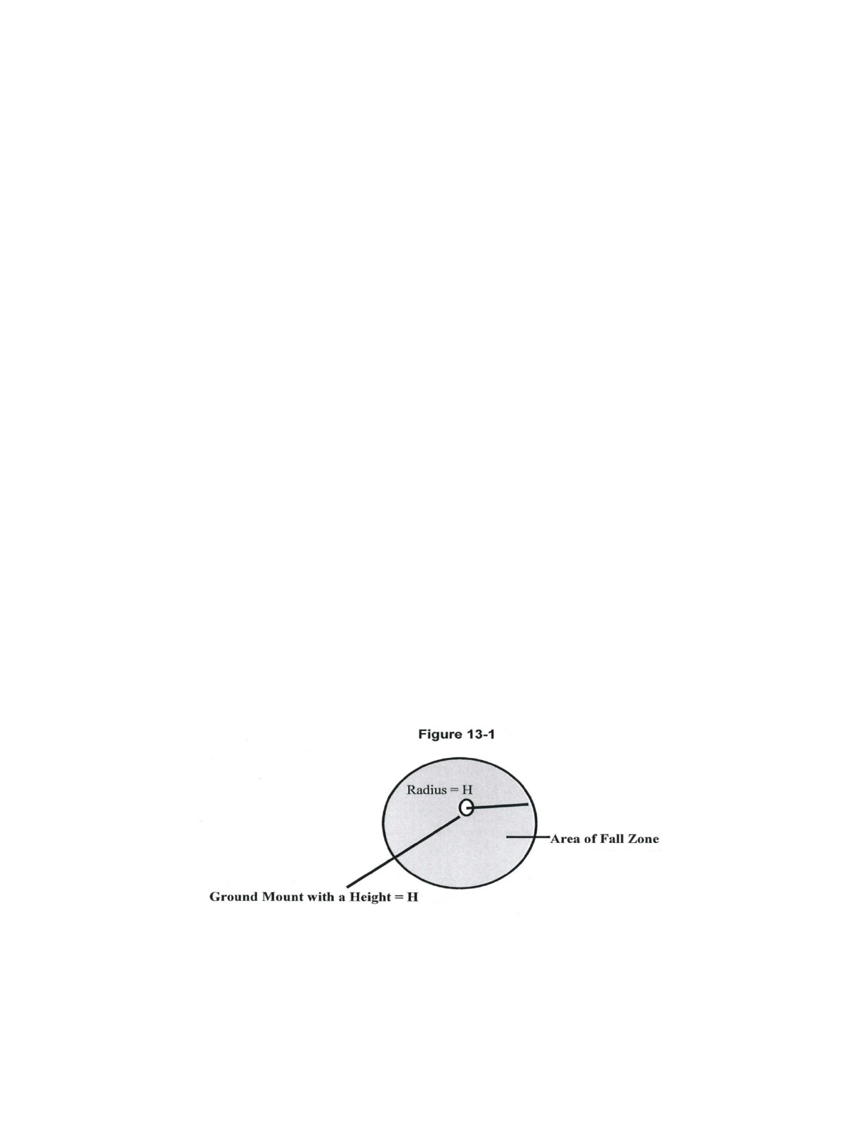
PLYMOUTH, NH ZONING ORDINANCE - MARCH 12, 2024
Page 48
Section 902 Definitions Specific to Personal Wireless Service Facilities
ANTENNA: The surface from which wireless radio signals are sent and/or received by a personal wireless
service facility.
ANTENNA ARRAY: A collection of antennas attached to a mount to send and receive radio signals.
AVERAGE TREE CANOPY HEIGHT: The average height of the twenty-five tallest trees within 150 feet of
the base of the Personal Wireless Service Facility.
CAMOUFLAGE: A PWSF that is disguised in a way that the appearance to a viewer is such that the object
does not look like the facility it functions as.
CARRIER: A company that provides personal wireless services, also sometimes referred to as a provider.
CONCEAL: A PWSF that is hidden, part of an existing or proposed structure, or placed within an existing
or proposed structure.
CO-LOCATION: The use of a single mount on the ground by more than one carrier (vertical co-location) or
the same carrier with multiple licenses, and/or the use of several mounts on an existing building or
structure by more than one carrier or the same carrier with multiple licenses.
ENVIRONMENTAL ASSESSMENT (EA): An EA is a document required by the Federal Communications
Commission (FCC) and the National Environmental Policy Act (NEPA) when a personal wireless service
facility is placed in certain designated areas.
EQUIPMENT SHELTER: An enclosed structure, cabinet, shed, vault, or box near the base of the mount
within which are housed equipment for personal wireless service facilities such as batteries and
electrical equipment. Equipment shelters are sometimes referred to as base transceiver stations.
FACILITY: See Personal Wireless Service Facility.
FALL ZONE: The area on the ground from the base of a ground-mounted personal wireless service facility
that forms a circle with a radius equal to the height of the facility, including any antennas or other
appurtenances, as set forth in Figure 13-1. The fall zone is the area within which there is a potential
hazard from falling debris (such as ice) or collapsing material.
GUYED TOWER: A monopole or lattice tower that is secured to the ground or other surface by diagonal
cables for lateral support.
HEIGHT: The height above ground level (AGL) from the natural grade of a site to the highest point of a

PLYMOUTH, NH ZONING ORDINANCE - MARCH 12, 2024
Page 49
structure.
LATTICE TOWER: A type of mount with multiple legs and structural cross bracing between the legs that is
self-supporting and free standing.
MAST: A thin pole that resembles a street light standard or a telephone pole. A dual-polarized antenna is
typically deployed on a mast.
MONOPOLE: A thicker type of mount than a mast that is self supporting with a single shaft of wood,
steel, concrete, or other material that is designed for the placement of antennas and arrays along the
shaft.
MOUNT: The structure or surface upon which antennas are mounted, including the following four types
of mounts:
• Roof-mounted. Mounted on roof of a building
• Side-mounted. Mounted on the side of a building
• Ground-mounted. Mounted on the ground
• Structure-mounted. Mounted on a structure other than a building
PERSONAL WIRELESS SERVICE FACILITY: Facility for the provision of personal wireless services, as defined
by the Telecommunications Act of 1996, as amended. Personal Wireless Service facilities include a
mount, antenna, equipment shelter, and other related equipment.
PERSONAL WIRELESS SERVICES: The three types of services regulated by this Ordinance: Commercial
mobile radio services, unlicensed wireless services, and common carrier wireless exchange access
services as described in the Telecommunications Act of 1996, as amended.
RADIO FREQUENCY (RF) ENGINEER: An engineer specializing in electrical or microwave engineering,
especially the study of radio frequencies.
RADIO FREQUENCY RADIATION (RFR): The emissions from personal wireless service facilities.
SECURITY BARRIER: A wall, fence, or berm that restricts an area from unauthorized entry or trespass.
SEPARATION: The distance between one carrier's array of antennas and another carrier's array.
Section 903 Location
Personal wireless service facilities shall be allowed, in accordance with the Use Regulations and other
provisions of this article, as either primary or accessory uses in all zones in the Town of Plymouth
provided that the Design Standards of this Article are met.
Personal wireless service facilities shall be located when possible on existing structures, including but not
limited to buildings, water towers, existing personal wireless service facilities, utility poles or towers, and
related facilities provided that such installation preserves the character and integrity of those structures.
If the applicant demonstrates that it is not feasible to locate on an existing structure, ground-mounted
personal wireless service facilities shall be designed so as to be camouflaged or concealed to the
greatest extent possible, including but not limited to: use of compatible building materials and colors,
screening, landscaping, and placement within trees.
Section 904 Use Regulations

PLYMOUTH, NH ZONING ORDINANCE - MARCH 12, 2024
Page 50
904.1 Existing Tower Structures
Subject to the issuance of a Land Use Permit, carriers may locate a mount and/or antenna on any guyed
tower, lattice tower, mast, monopole, or utility pole in existence prior to the adoption of this Article, or
on any personal wireless service facility previously approved under the provisions of this Article so long
as the co-location complies with the approved site plan.
904.2 Reconstruction of Existing Tower Structures
All existing guyed tower, lattice tower, monopole, or mast in existence prior to the adoption of this
Article may be reconstructed so long as the height of the structure is not increased. The mount shall be
replaced with a similar mount that does not increase the visual impact on the community. Site Plan
Review approval and a Land Use Permit are required.
904.3 Existing Structures
Subject to the Design Standards of this Article, a carrier may locate a personal wireless service facility on
an existing structure or building. Site Plan Review approval is required.
904.4 Ground-mounted Facility
A personal wireless service facility involving construction of a ground mount shall require Site Plan
Review approval and a Land Use Permit and be subject to the provisions of this Article.
Section 905 Design Standards
905.1 Height Requirements
HEIGHT, MAXIMUM: In no case shall a personal wireless service facility exceed two hundred (200) feet in
height, unless the mount for the facility was greater than two hundred (200) feet in height prior to the
adoption of this Article.
HEIGHT, EXISTING STRUCTURES AND UTILITY POLES: Carriers that locate new personal wireless service
facilities on water towers, electric transmission and distribution towers, utility poles and similar existing
utility structures, guyed towers, lattice towers, masts, and monopoles may be permitted to increase the
height of those structures no more than at ten (10) feet. This increase in height shall only be permitted
once for each structure.
HEIGHT, OTHER EXISTING STRUCTURES: The height of a personal wireless service facility shall not
increase the height of a structure by more than ten (10) feet, unless the facility is completely
camouflaged; for example a facility completely within a flagpole, steeple, or chimney. The increase in the
height of the structure shall be in scale and proportion to the structure as originally configured and shall
be determined by the Planning Board during Site Plan Review. A carrier may locate a personal wireless
service facility on a building that is legally nonconforming with respect to height, provided that the
provisions of this Article are met.
HEIGHT, GROUND-MOUNTED FACILITIES: Ground-mounted personal wireless service facilities shall not
project higher than twenty (20) feet above the average tree canopy height.
PLANNING BOARD FLEXIBILITY: HEIGHTS: In reviewing a Site Plan Review application for a personal
wireless service facility, the Planning Board may permit an increase in the height of a ground-mounted
facility up to forty (40) feet above the average tree canopy height, if no material increase in visual or
environmental impacts will result from the increase height. The visual and environmental criteria of this
Article and the Site Plan Review Regulations shall be the guidelines in making this determination.

PLYMOUTH, NH ZONING ORDINANCE - MARCH 12, 2024
Page 51
905.2 Setbacks
All personal wireless service facilities, their equipment shelters and fences shall comply with the building
setback provisions of the zoning district in which the facility is located.
905.3 Fall Zone for Ground Mounts
In order to ensure public safety, the minimum distance from the base of any ground-mount of a personal
wireless service facility to any property line, public road, habitable dwelling, business or institutional use,
or public recreational area shall be, at a minimum, the distance equal to the fall zone, as defined in this
Article. The fall zone may cross property lines, so long as the applicant secures a fall zone easement from
the affected property owner(s). The area of the easement shall be shown on all applicable plans
submitted to the Town, and the terms of the easement shall be provided as part of the Site Plan Review.
905.4 Fall Zone for Non-Ground Mounts
In the event that an existing structure is proposed as a mount for a personal wireless service facility, a fall
zone shall not be required, but the setback provisions of the zoning district shall apply. In the case of pre-
existing non-conforming structures, personal wireless service facilities and their equipment shelters shall
not increase any non-conformities.
905.5 Visibility
Personal wireless service facilities shall be designed to protect the existing environment and minimize
visual impacts through the design and color of the facility and camouflage or concealment of the
facilities. The design and mitigation of the visual impacts of the personal wireless service facility shall be
determined by the Planning Board through the Site Plan Review process.
905.6 Lighting
• Personal wireless service facilities shall be illuminated only if required by the Federal Aviation
Administration (FAA).
• Lighting of equipment structures and any other facilities on site shall be shielded from abutting
properties.
905.7 Signage
Signs shall be limited to those needed to identify the property and the owner and warn of any danger. All
signs shall comply with the requirements of the Plymouth Zoning Ordinance.
905.8 Security Barrier
The Planning Board shall have final authority on whether a ground-mounted personal wireless service
facility should be surrounded by a security barrier.
905.9 Antenna Types
Any antenna array placed upon an existing or proposed ground mount, utility pole, or transmission line
mount shall have a diameter of no more than four (4) feet, exclusive of the diameter of the mount. A
larger diameter antenna array may be permitted after a finding by the Planning Board that the visual
impacts of a larger antenna array are negligible.
905.10 Hazardous Waste
No hazardous waste shall be discharged on the site of any personal wireless service facility. If any
hazardous materials are to be used on site, there shall be provisions for full containment of such
materials. An enclosed containment area shall be provided with a sealed floor, designed to contain at

PLYMOUTH, NH ZONING ORDINANCE - MARCH 12, 2024
Page 52
least one hundred and ten percent (110%) of the volume of the hazardous materials stored or used on
the site.
905.11 Noise
Personal wireless service facilities shall not generate noise in excess of that permitted under the
Plymouth Noise Ordinance.
905.12 Radio Frequency Radiation (RFR) Standards
All equipment proposed for a personal wireless service facility shall be fully compliant with the FCC
Guidelines for evaluating the Environmental Effects of Radio frequency Radiation (FCC Guidelines), under
Report and Order, FCC 96-326, published on August 1, 1996 and all subsequent amendments.
Section 906 Monitoring and Maintenance
906.1 Maintenance
The owner of the facility shall maintain the personal wireless service facility in good condition. Such
maintenance shall include, but shall not be limited to, painting, structural integrity of the mount and
security barrier, and maintenance of the buffer areas and landscaping.
906.2 Monitoring
As part of the issuance of the site plan approval or Building Permit, the property owner shall agree that
the Town of Plymouth may enter the subject property to obtain RFR measurements and noise
measurements at the expense of the carrier. The town shall provide reasonable written notice to the
carrier and landowner and provide them the opportunity to accompany the Town representatives when
the measurements are conducted.
906.3 Security for Removal
Recognizing the hazardous situation presented by abandoned and unmonitored telecommunications
facilities, the Planning Board shall set the form and amount of security that represents the cost for
removal and disposal of abandoned telecommunications facilities in the event that a facility is
abandoned and the facility owner is unwilling or unable to remove the facility. The amount of the
security shall be based upon the removal cost plus fifteen percent (15%) provided by the applicant and
certified by a professional civil engineer license in the State of New Hampshire. The owner of the facility
shall provide the Planning Board with a revised removal cost estimate and structural evaluation prepared
by a professional civil engineer licensed in the State of New Hampshire every five (5) years from the date
of the Planning Board's approval of the site plan. If the cost has increased more than fifteen percent
(15%) then the owner of the facility shall provide additional security in the amount of the increase.
Section 907 Abandonment or Discontinuation of Use
907.1 Notification
At such time that a carrier plans to abandon or discontinue operation of a personal wireless service
facility, such carrier will notify the Town by certified U.S. Mail of the proposed date of abandonment or
discontinuation of operations. Such notice shall be given no less than thirty (30) days prior to
abandonment or discontinuation of operations. In the event that a carrier fails to give such notice, the
personal wireless service facility shall be considered abandoned upon such discontinuation of
operations.
907.2 Removal

PLYMOUTH, NH ZONING ORDINANCE - MARCH 12, 2024
Page 53
Upon abandonment or discontinuation of use, the owner of the facility shall physically remove the
personal wireless service facility within ninety (90) days from the date of abandonment or
discontinuation of use. “Physically remove” shall include, but not be limited to:
• Removal of antennas, mount, equipment shelters, and security barriers from the subject
property.
• Proper disposal of the waste materials from the site in accordance with local and state solid
waste disposal regulations.
• Restoring the location of the personal wireless service facility to its natural condition, except that
any landscaping and grading shall remain in the after condition.
907.3 Failure to Remove
If the owner of the facility does not remove the facility upon the Town's order, then the Board of
Selectmen shall, after holding a public hearing with notice to the owner and abutters, issue a declaration
of abandonment. The owner of the facility shall dismantle and remove the facility within ninety (90) days
of receipt of the declaration of abandonment by the Board of Selectmen.
If the abandoned facility is not removed within ninety (90) days, the Town may execute the security to
pay for this action.
ARTICLE X: IMPACT FEES
Section 1001 Authority and Purpose
This article is adopted pursuant to RSA 674:16 and 674:21. The purpose of this article is to allow the
Town to equitably allocate the costs associated with development to meet the needs occasioned by
particular development for the construction or improvement of off-site capital facilities owned or
operated by the Town.
Section 1002 Definitions
In this article the following definitions apply:
IMPACT FEE: A fee or assessment imposed upon development, including subdivision, building
construction or other land use change, in order to help meet the needs occasioned by that development
for the construction or improvement of capital facilities owned or operated by the Town, including and
limited to water treatment and distribution facilities; waste water treatment and disposal facilities;
sanitary sewers; storm water; drainage and flood control facilities; public road systems and rights-of-way;
municipal office facilities; public school facilities; the municipality's proportional share of capital facilities
of a cooperative or regional school district of which the municipality is a member; public safety facilities;
sold waste collection, transfer, recycling, processing and disposal facilities; public library facilities; and
public recreational facilities not including public open space.
DEVELOPMENT: The construction, improvement, replacement, addition, expansion, or other use of a
structure or land which requires approval of the Planning Board, Zoning Board of Adjustment, or the
issuance of a building permit or certificate of occupancy. Development also includes, without limitation
by reason of enumeration, subdivisions, nonresidential development of land, construction or expansion
of structures, or commencement or expansion of uses, which may reasonably be expected to have an
impact on the municipal facilities described in Section 1002. Development does not include such
structures or uses which may not be reasonably expected to have an impact on such municipal facilities,

PLYMOUTH, NH ZONING ORDINANCE - MARCH 12, 2024
Page 54
including the lawful, in-kind replacement or reconstruction of an existing structure that was damaged or
destroyed by fire, accident or other natural disaster, if the replacement occurs with 2 years after such
damage or destruction.
Section 1003 Administration
This article shall be administered by the Planning Board, which shall adopt regulations establishing
procedures and guidelines for the implementation of this article. As this article is adopted pursuant to
the innovative zoning provisions of RSA 674:21, administrative decisions made by the Planning Board
under this article may not be appealed to the Zoning Board of Adjustment, but shall be appealed
pursuant to RSA 677:15. The Planning Board may adopt regulations, which establish threshold levels of
development for consideration of impact fee assessments under this article.
Section 1004 Assessment and Determination of Impact Fee
Any development as defined with Section 1002 shall be liable for the payment of an impact fee in
accordance with this article. The amount of the impact fee shall be determined as follows:
1004.1 Site Specific Impacts
The Planning Board shall review each development as defined in Section 1002 to determine if an off-site
impact is generated that is subject to an impact fee determination under this article. The development
shall be subject to such a fee if the Planning Board finds that the costs required for construction or
improvement of the municipal infrastructure described in Section 1002 or any other Town owned or
operated municipal capital facilities is appropriate. To determine if it is appropriate to impose such an
impact fee, and if so, the amount of the impact fee, the Planning Board shall determine the off-site
improvements reasonably related to the development and shall then determine whether developer
contribution to the payment of costs for such improvements is appropriate. In making such
determination, the Planning Board shall consider the future and indirect benefits accruing to the
development from the improvement(s), noting that permanent improvements are not made solely with
reference to present conditions. The Planning Board may then determine the amount of the impact fee
which shall be that portion of the cost, which bears a rational nexus to the needs, created by, and special
benefits conferred upon, the development and which considers the burdens imposed upon the Town
either forthwith or in the immediate future.
1004.2 Special Exceptions
Upgrading of existing facilities and infrastructures, the need for which is not created by new
development, shall not be paid for by impact fees.
Section 1005 Assessment Handling and Collection of Impact Fees
1005.1 An impact fee shall be accounted for separately and shall be segregated from the Town's
general fund. An impact fee may be spent upon order of the Board of Selectmen, shall be exempt from
all provisions of RSA 32 relative to limitation and expenditure of Town monies, and shall be used solely
for the capital improvements for which it was collected, or to recoup the cost of capital improvements
made in anticipation of the needs which the fee was collected to meet.
1005.2 Each impact fee imposed pursuant to this article shall be assessed prior to, or as a condition
for, the issuance of a Land Use Permit or other appropriate permission to proceed with the

PLYMOUTH, NH ZONING ORDINANCE - MARCH 12, 2024
Page 55
development.
1005.3 An impact fee shall normally be collected prior to the occupancy of the development if a
certificate of occupancy is not required by the Town. However, in projects where off-site improvements
are to be constructed simultaneously with a project's development, and where the Town has
appropriated the necessary funds to cover such portions of the work for which it is responsible, the
Planning Board may advance the time of collection of the impact fee to the issuance of a Land Use
Permit. Nothing in this article prevents the Planning Board and the assessed party from establishing an
alternative, mutually acceptable schedule of payment.
1005.4 In the interim between assessment and collection of an impact fee, the Planning Board may
require the developer to post acceptable surety to guarantee future payment of assessed impact fees.
1005.5 Any portion of an impact fee which has not become encumbered or otherwise legally
bound to be spent for the purpose for which it was collected shall be refunded, with accrued interest,
after the expiration of 6 years from the date it is collected. When an impact fee calculation has been
predicted upon some portion of capital improvement costs being borne by the Town, a refund shall be
made upon the failure of the Town Meeting to appropriate the Town's share of the capital improvement
costs within 6 years.
Section 1006 On-Site Improvements
This article shall not affect the authority or ability of the Planning Board or the Zoning Board of
Adjustment to consider and impose conditions relating to on-site conditions associated with
development, including, but not limited to, internal roads, drainage, water and sewer connections, and
other factors as may be appropriate to the circumstances.
Section 1007 Waivers
The Planning Board may waive the imposition of an impact fee upon written request of the developer or
person assessed if the Board finds that good cause is demonstrated for such waiver. Prior to the approval
of any such waiver, the Planning Board shall notify the public and the Selectmen and shall hold a public
hearing on the waiver request. The burden shall be upon the person requesting the waiver to
demonstrate that it is in the public interest to do so and that good cause for the waiver exists.
Section 1008 Effective Date
This article shall take effect upon its adoption.
ARTICLE XI: ADMINISTRATION AND ENFORCEMENT
Section 1101 Administrative Official
This Ordinance shall be administered and enforced by the Board of Selectmen or their designee.
1101.1 Violations
Pursuant to RSA 676, the Board of Selectmen, in the name of the Town, may institute, or cause to be

PLYMOUTH, NH ZONING ORDINANCE - MARCH 12, 2024
Page 56
instituted, legal or equitable action(s) appropriate or necessary, in their sole discretion, to enforce this
Ordinance. The Selectmen may institute such action against the property owner, a tenant, an occupant
or a person in possession of the property upon which such a claimed violation occurs, or any
combination thereof, as the Selectmen deem appropriate to secure compliance, and to impose fines,
penalties, forfeitures upon the person(s) responsible for the violation.
1101.2 Penalty
Fines and penalties for violations of this Ordinance shall be consistent with RSA 676:17-a and 676:17-b.
Section 1102 Building Regulations
1102.1 Appointment
It shall be the duty of the Board of Selectmen to appoint an Administrative Officer to enforce the
provisions of this Section. The person appointment shall be known as the “Building Inspector”.
The Building Inspector shall receive applications and fees for the erection or alteration of buildings as
provided in this Ordinance; keep complete records of applications and his action on the applications;
promptly survey and inspect all buildings, alterations, or uses proposed; accept and deposit with the
Town all fees collected under the Ordinance; issue permits for erection or alteration of all buildings and
use of land if, in his opinion, the proposal complies with the laws of the State, this Ordinance, other
Town Ordinances and By-Laws; and shall take such action in the enforcement of this Ordinance as may
be directed by the Selectmen.
1102.2 Duties of the Building Inspector
The Building Inspector shall be the Administrative Officer of this Section. He shall:
• Receive applications and fees for the erection and/or alteration of buildings
• Make available all applications
• Keep complete records of his action on all applications
• Issue or deny permits, based on the compliance of the proposed project with this Ordinance, the
Zoning Ordinance of the Town of Plymouth and all other Town and State Ordinances and
regulations, including the Americans with Disabilities Act.
• Regularly inspect buildings during the process of erection or alterations.
• Bring to the attention of the Board of Selectmen any violations of this Ordinance and take action
in the enforcement of this Ordinance.
• Accept and deposit with the Town all fees collected by him under this Ordinance.
• Act in cooperation with the Plymouth Fire Department in any manner in which their duties, as
prescribed by law, may coincide or conflict.
• Examine and, if necessary, order the repair, vacancy, or demolition of unsafe buildings and
structures.
1102.3 Duties of Applicant
Any person, persons, partnership, trust, or corporation intending to construct or erect a new building or
to make alterations not specifically exempted in this Ordinance shall first make application for a permit
on forms obtained from the Building Inspector.
• Said application shall be accompanied by a drawing or plan for any proposed building or
alteration
• Said application shall be accompanied by a signed statement of the intended use of the building
upon completion of the project.

PLYMOUTH, NH ZONING ORDINANCE - MARCH 12, 2024
Page 57
• The applicant shall display prominently at the site of the construction or alteration a card issued
by the Building Inspector evidencing his permit.
• The applicant shall make the premises accessible to the Building Inspector, his consultants and
Fire Department Inspector, at reasonable times, for the performance of their duties.
• The applicant shall notify the Building Inspector of the start of construction under a building
permit at least twenty-four (24) hours in advance, and he shall, if a schedule of inspection is
required by the Building Inspector, notify the Building Inspector of the progress of construction
at least twenty-four (24) hours prior to those times specified by the Building Inspector.
• No electrical or plumbing work shall be covered over unless it has been inspected and approved
by the Building Inspector or designee.
• The applicant shall not occupy or use the new building or altered space unless the Building
Inspector has, after an inspection of the complete work, issued a notice authorizing said
occupancy of use.
• Permits shall also be obtained from the Building Inspector for all electrical and plumbing work,
and for the installation of pre-certified manufactured housing, prior to the commencement of
the work or installation.
• Permits for oil-burning and fuel gas appliances shall be obtained from the Plymouth Fire Dept.
prior to operation or the Fire Chief's schedule.
1102.4 Application Fees
For the purpose of determining these fees, the square footage shall be taken from the outside
measurements of all floors, including basements.
Fees for permits may be set by the Board of Selectmen after a public hearing, and do not have to be
voted on at the annual Town Meeting.
1102.5 Issuance of Permits
A permit shall become invalid unless operations are commenced within twelve months from the date of
issuance. The owner (or his representative) of any building or structure for which a building permit is
granted shall, upon completion of the work authorized, notify the Building Inspector. The Inspector shall
inspect the building or structure within a reasonable time. If said work has been completed in
accordance with all applicable statutes, ordinances, rules and regulations, including any grading or
features necessary for health and safety of occupancy, the Inspector shall issue a notice to the owner
specifying that the building may be occupied for the purpose stated in the permit.
1102.6 Codes Adopted by Reference
The Town of Plymouth hereby adopts the State Building code as defined in RSA 155-A: 1, IV.
1102.7 Building Requirements
No building or structure shall be erected, altered, rebuilt, remodeled or substantially repaired, or new
paving applied over previously unpaved surfaces, unless in compliance with the Codes adopted in
Section 1102.6, the Zoning Ordinance of the Town of Plymouth and the following building requirements.
Sewage Disposal: All dwellings and all commercial, industrial, or public building shall be connected to
the public sewer system (Plymouth Village Water & Sewer District) were available. Where the public
sewer system is not available, a suitable subsurface disposal system shall be provided. The type, size and
construction of all such systems shall conform to New Hampshire Laws and Regulations.

PLYMOUTH, NH ZONING ORDINANCE - MARCH 12, 2024
Page 58
Completion of Buildings: All buildings or additions shall be completed as to outside appearances, not
including painting or landscaping, within one year from the date of issuance of a permit. A one-year
extension of a building permit may be granted by the Building Inspector upon receipt of a written
request for extension at least fourteen (14) days prior to the expiration of a permit. All buildings and
structures shall conform to all applicable laws, rules, and regulations for fire protection and safety.
1102.8 Work Exempt from Permitting
The following shall be exempt from permits provided they comply with all Zoning requirements:
• One-story detached accessory structures used as tool and storage sheds, playhouses, and similar
uses provided the floor area does not exceed 120 square feet.
• Fences not over four feet high, or retaining walls not over four feet high.
• Water tanks supported directly on grade if the capacity does not exceed 5,000 gallons and the
ratio of height to diameter or width does not exceed 2 to 1.
• Painting, wallpapering, tiling, floor coverings, trim, cabinetry, counter tops, moveable cases,
counters and partitions, appliances, like-for-like replacement for lighting or plumbing fixtures
that do not require “rough-in”, and similar finish work.
• Non-structural siding and like-for-like replacement of roofing materials
• Prefabricated swimming pools
• Shade cloth structures constructed for nursery or agricultural purposes
• Swings and playground equipment
• Window awnings supported by an exterior wall, which do not project more than 54 inches.
Repairs : A permit is not required for ordinary repairs or maintenance of structures, repaving or repair of
any previously paved surface or the clearing of stoppages or the repairing of leaks in plumbing supplies
or drains. Such repairs shall not include the removal or cutting away of any wall, partition, structural
beam or load-bearing support, or the removal or change of any required means of egress, or
rearrangement of parts of a structure affecting the egress requirements. Ordinary repairs do not include
addition to, alteration of, relocation of any standpipe, water supply, sewer, drainage, gas, oil, waste vent
or similar piping, electrical wiring or mechanical or other work affecting public health or general safety.
1102.9 Appeals
Any person aggrieved by a decision of the Building Inspector may appeal to the Zoning Board of
Adjustment, which shall serve as the Building Code Board of Appeals. This Board of Appeals may vary the
application of any provision of the Building Code in any case when the enforcement or the Building Code
would do manifest injustice and would be contrary to the spirit and purpose of the Building Code and
the public interest.
1102.10 Amendments
This Ordinance may be amended by a majority vote of any legal town meeting when such amendment is
published in the warrants calling for the meeting.
1102.11 Enforcement
Upon any well-founded information that these Building Regulations or the State Building Code is being
violated, the Building Inspector or the Selectmen shall take immediate steps to enforce the provisions of
this Ordinance by seeking an injunction in the Superior Court or by any other appropriate legal action.
Whoever violates any of the above regulations shall be subject to the fines and penalties set forth in RSA
676:17 and shall be liable for costs and attorney's fees incurred by the Town in enforcing the regulations.

PLYMOUTH, NH ZONING ORDINANCE - MARCH 12, 2024
Page 59
1102.12 Takes Effect
This Ordinance shall take effect upon passage.
1102.13 Conflicting Provisions
Wherever the regulations made under that authority hereof differ from those described by statute,
ordinance, or other regulations, that provision which imposes the greater restriction, or the higher
standard shall govern.
1102.14 Validity
If any section, clauses, provision, portion or phrase of this Ordinance shall be held invalid or
unconstitutional by any court of competent authority, such a holding shall not affect, impair, or
invalidate any other section, clause provision, portion or phrase of this Ordinance.
(Adopted by official ballot March 2009)
ARTICLE XII: BOARD OF ADJUSTMENT
Section 1201 Creation of the Board of Adjustment
There shall be a Board of Adjustment as provided by NH RSA 673:3,I
Section 1202 Membership of the Board of Adjustment
The Board of Adjustment shall consist of five members. The Selectmen shall annually appoint one or two
members for a term of three years. Members of the ZBA in office on the effective date of this Ordinance
shall continue to serve their terms and that their successors will be appointed in accordance with the
changed Ordinance. The Selectmen shall appoint up to five (5) alternate members of the Board of
Adjustment for a term of three years. A member shall be removable by Selectmen upon written notice
and after a public hearing. Vacancies for any unexpired term shall be filled by appointment by the
Selectmen.
Section 1203 Rules of the Board of Adjustment
The Board of Adjustment shall adopt rules to govern its proceedings in accordance with the provisions of
this Ordinance and NH RSA Chapter 676. Meetings of the board shall be held at the call of the chairman
and at such other times as the Board may determine. All meetings of the board shall be open to the
public, except executive sessions. The Board shall keep minutes of its proceedings showing the vote of
each member upon each question or, if absent or failing to vote, indicating such fact, and shall keep
records of its examinations and other official actions, all of which shall be filed in the Office of the Board
of Adjustment and shall be public record.
Section 1204 Duties of the Board of Adjustment
The duties and powers hereby conferred upon the Board of Adjustment include those listed below as
well as any other power conferred upon such Boards by the Statutes of the State of New Hampshire.

PLYMOUTH, NH ZONING ORDINANCE - MARCH 12, 2024
Page 60
1204.1 Appeals
The Board of Adjustment may hear and decide a case where it is alleged there is an error in any order,
requirement, decision, or determination made by any official in the enforcement of this Ordinance.
1204.2 Special Exceptions
A. The Board of Adjustment may, in appropriate cases, and subject to safeguards as determined by
the Board, grant a permit for a special exception. The Board, in acting on an application, shall
take into consideration the following conditions:
I. The proposed use(s) shall be only those allowed in this Ordinance by Special Exception.
II. The specific site is an appropriate location and of adequate size for the use.
III. The use, as developed, will not adversely affect the character of the area in which the
proposed use will be located.
IV. There will be no nuisance or serious hazard to vehicles or pedestrians.
V. The use will not place excessive or undue burden on Town services and facilities.
VI. There would be no significant effect resulting from such use upon the public health, safety
and general welfare of the neighborhood in which the use would be located.
B. If the Board of Adjustment approves an application for a special exception, it shall impose
relevant conditions specified in Section 1204:3 and all other applicable specific standards in this
Ordinance. The Board shall also impose such additional conditions as it finds reasonably
appropriate to safeguard the neighborhood or otherwise serve the purposes of this Ordinance,
including, but not being limited to, the following:
I. Yards larger in area or in any specified dimension than those required by the Ordinance;
II. Screening of all or part of the premises of the proposed use by walls, fencing or planting;
III. modification of the design of any building involved in the proposed use;
IV. Parking facilities greater than those otherwise required under this Ordinance;
V. Limitations of the number of occupants or employees upon the premises, and restrictions of
the method and/or time of operation and use, and of size or extent of facilities;
VI. Limitations upon the size, location and/or lighting of signs more restrictive than those
otherwise imposed by this Ordinance, including the prohibition of signs where, in the
opinion of the Board, their display would be contrary to the purposes of the Ordinance.
VII. Requiring that any future enlargement or alteration of use be accomplished only with the
approval of the Board of Adjustment.
C. A special exception shall be void if active and substantial building or development has not begun
within two years (24 months) from the date the special exception was granted by the Zoning
Board of Adjustment. Special exceptions may be extended once for a period of no more than 12
months by the Zoning Board on receipt of a written request for extension at least 14 days prior
to the expiration date of the special exception and following a public hearing upon the request.
The applicant shall be responsible for the cost of notification as whether or not to grant the
extension, the Board shall consider the circumstances of the applicant's request, any
amendments to the Zoning Ordinance, any changes to the neighborhood in which the approved
use is located, and any other factors the Board determines to be relevant. (Amended at town
meeting 3-8-16).
1204.3 Standards Guiding the Granting of Special Exceptions for Specific Uses
A. Multiple Unit Dwellings
I. Site suitability: The site is suitable for the proposed use and the proposed total number of
units. This includes adequate vehicular and pedestrian access, and the availability of
appropriate utilities to serve the intended use including water, sewage disposal, stormwater

PLYMOUTH, NH ZONING ORDINANCE - MARCH 12, 2024
Page 61
disposal, electricity, broadband, and similar utilities.
II. Character of the site development: The proposed layout and design of the site shall consider
the character of the neighborhood. This shall include, but not be limited to, the relationship
of buildings to the street, the amount, location, and screening of off-street parking, the
treatment of yards and setbacks, the buffering of adjacent properties, and provisions for
vehicular and pedestrian access to and within the site.
III. Character of the buildings and structures: The design of any new buildings or structures and
the modification of existing buildings or structures on the site shall be compatible with the
established character of the neighborhood or shall be compatible with the general design of
residential buildings in Plymouth. This shall include, but not be limited to, the scale, height,
and massing of the building or structure, the roof line, the architectural treatment of the
front or street elevation, the location of the principal entrance, and the material and colors
proposed to be used.
IV. Preservation of natural, cultural, historic, and scenic resources: The proposed use and
development of the site shall preserve identified natural, cultural, historic, and scenic
resources on the site and shall not degrade such identified resources on abutting properties.
This shall include, but not be limited to, identified wetlands, floodplains, significant wildlife
habitat, stonewalls, mature tree lines, cemeteries, graveyards, designated historic buildings or
sites, scenic views, and viewsheds.
V. External impacts: The external impacts of the proposed use on abutting properties and the
neighborhood shall be minimized. This shall include, but not be limited to, traffic, noise,
odors, and exterior lighting and glare.
VI. Additional Criteria of Multiple Unit Dwellings in the Agricultural Zone:
a. Minimum yard dimensions shall be fifty (50) feet in the front, side and rear.
b. All lots shall conform to the area requirements as specified in Section 304.
B. Industry, Manufacturing or Industrial Parks
I. Building Design – All structures are designed with due consideration to existing and
proposed neighborhood structures. The design of structures takes advantage of topography,
and reflects the character, scale and purpose of the areas of which it is a part.
II. Traffic Access – All proposed site traffic access ways are adequate but not excessive in
number, adequate in grade, width, and alignment and visibility.
III. Circulation and Parking – The interior traffic circulation and parking system is adequate.
IV. Landscaping – The proposed site is properly landscaped to further enhance the natural
qualities of the land. Where adjacent land use dictates, proper screening and buffer zones
may be required. Where, in the opinion of the Planning Board, an industrial process or
product is of potentially explosive nature, landscaping may include blast containment, blast
dampening or blast channel features.
V. Water and Sewage – Availability of adequate water and sewage treatment capabilities for
the proposed use.
VI. Pollution – All resulting emissions must comply with appropriate State and Federal
regulations.
VII. Noise – noise level at the property line shall not exceed 70 decibels.
VIII. Flashing and Vibrations – Objectionable flashing and vibrations shall not occur.
C. Rooming House
I. In addition to the minimum lot size requirements established elsewhere in this Ordinance, a
minimum lot size of 1,000 square feet shall be required for every occupant, but in no case
shall the total area of the lot be less than 11,000 square feet.
II. A Rooming House must be occupied by the owner or an on-site manager, who shall be

PLYMOUTH, NH ZONING ORDINANCE - MARCH 12, 2024
Page 62
responsible for the safe, efficient and harmonious operation of the dwelling.
III. The total occupancy of a Rooming House, including the owner or an on-site manager, shall
be no greater than 16 residents.
D. Off-Site Parking Facility
I. The proposed off-site parking facility must be located on land owned by, leased to, or legally
reserved for the owner of the use for which the parking facility is provided.
II. The proposed off-site parking facility must be reasonably necessary.
III. The proposed off-site parking facility must be compatible to the spirit and terms of this
Ordinance.
IV. The proposed off-site parking facility must be within 300 feet of the use for which the
parking facility is provided.
E. Parking Spaces within five (5) feet of a property line in Multi-Family Residential and civic
Industrial zones
I. A detailed plan showing the layout, dimensions, screening, curbing, and number of parking
spaces must be submitted with the application for Special Exceptions
II. Parking spaces must be screened by fencing, shrubs or other means
III. The curb cut to access the parking space or parking facility shall be appropriate to the use,
but must not exceed twenty (20) feet in width
IV. Individual parking spaces must be clearly designated
V. An agreement to maintain the screening and parking area must be signed by the property
owner. Such agreement shall be reviewed and approved by the ZBA. Such agreement shall
be binding on the applicant and successor interests and be recorded at the Registry of Deeds
at the owner's expense. A violation of this agreement shall be deemed a violation of the
Zoning Ordinance.
F. Residential Uses in the Village Commercial Zone
I. For units occupied by a related family, two (2) parking spaces per unit shall be provided
II. For units occupied by an unrelated family, one (1) parking space per bedroom shall be
provided
III. The facade, including windows, shall be residential in character
IV. Window signs are not permitted in the windows of residential units
1204.4 Variances
A. The Board of Adjustment may authorize a variance from the terms of this Ordinance, in
accordance with NH RSA 674:33, where the Board of Adjustment finds that all of the following
conditions apply:
I. The variance will not be contrary to the public interest.
II. The spirit of the ordinance is observed.
III. Granting the variance would do substantial justice
IV. Granting the variance will not diminish the value of surrounding properties.
V. Literal enforcement of the provisions of the ordinance would result in unnecessary hardship,
meaning that owing special conditions of the property that distinguish it from other
properties in the area:
a. The proposed use is a reasonable one; and
b. No fair and substantial relationship exists between the general public purposes of the
ordinance provision and the specific application of that provision to the property; or
c. If the criteria in a. and b. are not established, an unnecessary hardship will be deemed to
exist if, and only if, owing to special conditions of the property that distinguish it from
other properties in the area, the property cannot be reasonable used in strict

PLYMOUTH, NH ZONING ORDINANCE - MARCH 12, 2024
Page 63
conformance with the ordinance, and a variance is therefore necessary to enable a
reasonable use of it.
B. In authorizing a variance, the Board of Adjustment may attach such conditions and safeguards as
it deems necessary to protect the neighborhood and the community, including but not limited to
a time limit when the variance will expire if not utilized.
C. A variance shall be void if active and substantial building or development has not begun within
two years (24 months) from the date the variance was granted by the Zoning Board of
Adjustment, provided that no such variance shall expire within 6 months after the resolution of a
planning application filed in reliance upon the variance. Variances may be extended once for a
period of no more than 12 months by the Zoning Board on receipt of a written request for
extension at least 14 days prior to the expiration date of the variance and following a public
hearing upon the request. The applicant shall be responsible for the cost of notification as
required by the Zoning Board of Adjustment Rules of Procedure. In deciding whether or not to
grant the extension, the Board shall consider the circumstances of the applicant's request, any
amendments to the Zoning Ordinance, any changes to the neighborhood in which the approved
use is located, and any other factors the Board determines to be relevant. (Amended at town
meeting 3-8-16).
D. Notwithstanding section A., the Board of Adjustment may grant a variance from the terms of the
zoning ordinance without finding a hardship arising from the condition of a premises subject to
the ordinance, when reasonable accommodations are necessary to allow a person or persons
with a recognized physical disability to reside in or regularly use the premises, provided that;
I. Any variance under this paragraph shall be in harmony with the general purpose and intent
of the Zoning Ordinance.
II. In granting any variance pursuant to this paragraph, the Board of Adjustment may provide,
in a finding included in the variance, that the variance shall survive only so long as the
particular person has a continuing need to use the premises.
1204.5 Decisions
A. In exercising the above mentioned power, the Board of Adjustment may, in conformity with the
powers granted to it by NH RSA Chapter 673, reverse or affirm wholly or partly, or may modify
the order, requirement, decision, or determination appealed from any may make such order or
decision as ought to be made and to that end shall have the powers of the officer from whom
the appeal is taken.
B. The concurring vote of three members of the Board shall be necessary to reverse any action of
an administrative official or to decide in favor of the applicant on any matter upon which the
Board is required to pass under this Ordinance.
Section 1205 Procedure for Submitting Appeals and Applications to the Board of
Adjustment
1205.1 Application for Procedure
All appeals and applications to the Board of Adjustment shall be in writing. Every appeal or application
shall refer to the specific provision of the Ordinance involved, and shall set forth the interpretation, the
special exception, or the variance for which application is being made. The cost of advertisement and
mailing shall be payable by the appellant prior to the required public hearing. Failure to pay such costs
shall constitute valid grounds for the Board to terminate further consideration and to deny the appeal or
application without public hearing.

PLYMOUTH, NH ZONING ORDINANCE - MARCH 12, 2024
Page 64
1205.2 Public Hearing and Notice to Abutters
Whenever a notice of appeal is filed or an application is made for a variance or special exception, the
Board of Adjustment shall hold a public hearing, and notice shall be given as follows: The appellant and
all of the abutters shall be notified of the hearing by certified mail, return receipt requested, stating the
time and place of the hearing, and such notice shall be given not less then five (5) days before the date
fixed for the hearing of the appeal or application. A public notice of the hearing shall be placed in a
newspaper of general circulation in Plymouth not less than five (5) days before the date fixed for the
hearing of the appeal or application. The public hearing shall be held within thirty (30) days of the
receipt of the notice of appeal or application.
1205.3 Notice to Other Boards
In addition to the notices sent as described above, the Board shall also send such a notice to the
Planning Board and to the Board of Selectmen, and either Board shall be proper party to appear and be
heard upon any such appeal or application. Upon the entry of any decision, report, or order in such a
proceeding, the Board of Adjustment shall cause a copy to be sent to the Planning Board. In those
proceedings before the Board of Adjustment at which the Planning Board submits its recommendations,
such recommendations shall be in the same format as that required of the Board of Adjustment in
reporting its decision.
1205.4 Continuation of Hearing
The hearing shall not be continued to another time except for good cause, and if so requested by the
applicant, all advertising costs shall be borne by the applicant.
1205.5 Decisions Following Public Hearing
Following the public hearing the Board shall act promptly to vote to deny, approve, conditionally
approve, or approve with modifications the appeal variance, or special exception. The Board of
Adjustment shall state in writing in sufficient detail its reason as to granting or denial of a special
exception or variance with particular reference to the standards or conditions applicable thereto. The
Board of Adjustment shall then inform the applicant in writing and the Board of Selectmen of its
decision. The decision shall be placed on file in the Office of the Board of Adjustment and made available
for public inspection within 72 hours after the decision is made.
Section 1206 Rehearing and Appeal Procedures
Whenever a person or a municipally seeks a rehearing of a zoning related order or decision the
procedures enacted under RSA Chapter 677 shall be followed.
ARTICLE XIII: MISCELLANEOUS PROVISIONS
Section 1301 Saving Clause
The validity of any section or provision of this Ordinance shall not invalidate any other section or
provision thereof.
Section 1302 Amendments
Amendments to this ordinance shall be made in accordance with the procedures enacted under RSA
675:3

PLYMOUTH, NH ZONING ORDINANCE - MARCH 12, 2024
Page 65
Section 1303 Effective Date
In effect upon passage.
ARTICLE XIV: ZONE BOUNDARY DESCRIPTIONS
Section 1401 Single-Family Residential
Beginning at the junction of Winter Street and Warren Street and going easterly along Warren Street to
Route 3. Then southerly along Route 3 to a point on the west side of Route 3 and the south end of
Crystal Springs, then southerly in a straight line to a point 1,550 feet west of Route 3 and 1,000 feet
north of Cummings Hill Road. Then westerly, parallel to the 1000 feet north of Cummings Hill to Thurlow
Street Extension. Then westerly, parallel to and 1000 feet north of Glove Hollow Brook for 4000 feet.
Then northerly in a straight line to the bridge over Tannery Brook on Texas Hill Road. Then northerly in a
straight line to the junction of Binks Hill Road Extension and Binks Hill Road. Then westerly,
perpendicular to Binks Hill Road, for 300 feet. Then northerly, parallel to and 300 feet west of Binks Hill
Road, to a point 300 feet south of Reservoir Road. Then westerly, parallel to and 300 feet south of
Reservoir Road, to a point south of the old concrete water tank (on a line perpendicular to Reservoir
Road). Then northerly to the new water tank. Then easterly, about 200 feet to a brook. Then northerly
along the brook to a point 400 feet south of the southern bank of the Baker River. Then easterly, parallel
to and 400 feet south of the bank of the Baker River to Old Ward Bridge Road. Then southerly, along Old
Ward Bridge Road to a point 200 feet north of Tamarack Drive. Then easterly, parallel to and 200 feet
north of Tamarack Drive, for 1500 feet. Then southerly, parallel to and 1500 feet east of Old Ward Bridge
Road, to a point 400 feet north of Highland Street. Then easterly, parallel to and 400 feet north of
Highland Street, to a point north of the junction of Highland and Broadway Streets. Then northerly, in a
straight line, parallel to and 500 feet west of Batchelder Street to a point 400 feet north of Merrill Street
(approximately 1800 feet). Then easterly, parallel to and 400 feet north of Merrill Street to a point 400
feet west of Langdon Park Road. Then northerly, parallel to and 400 feet west of Langdon Park Road to a
point 800 feet south of the Baker River. Then easterly, 800 feet south of the Baker River, to a point 700
feet north of Merrill Street. Then easterly, parallel to and 700 feet from Merrill Street, to a point 400 feet
east of Langdon Park Road. Then southerly, parallel to and 400 feet east of Langdon Park Road, a point
200 feet south of Merrill Street. Then easterly, parallel to and 200 feet south of Merrill Street to a point
200 feet west of Langdon Street. Then southerly, parallel to and 200 feet west of Langdon Street to a
point 200 feet north of Highland Street. Then westerly parallel to and 200 feet north of Highland Street
to Emerson St. Then southerly along the center of Emerson St. to Highland St. Then westerly along
Highland St. to a point opposite Cooper Street. Then south along Cooper Street to Hawthorne Street.
Then easterly along Hawthorne Street to Avery Street. Then southerly on Avery Street to Cummings
Street. Then easterly along Cummings Street to Langdon Street. Then southerly on Langdon Street to a
point 200 feet north of Pleasant Street. Then easterly parallel to and 200 feet north of Pleasant Street to
opposite Winter Street. Then southerly along Winter Street to Warren Street (the beginning point).
Section 1402 Multi-Family Residential
1402.1 South
Beginning at the junction of Winter and Warren Streets and going easterly along Warren Street to a

PLYMOUTH, NH ZONING ORDINANCE - MARCH 12, 2024
Page 66
point 250 feet west of Main Street. Then northerly, parallel to and 250 feet west of Main Street to the
south side of Highland Street. Then westerly along Highland Street to a point 200 feet west of Russell
Street. Then southerly, parallel to and 200 feet west of Russell Street to a point opposite Winter Street.
Then southerly on Winter Street to the junction of Warren Street (the point of beginning).
1402.2 Central
Beginning at a point on Highland Street 100 feet east of Langdon Street, then northerly parallel to and
100 feet east of Langdon Street to School Street. Then easterly along School Street 100 feet. Then
northerly, parallel to and 200 feet east of Langdon Street to Merrill Street. Then northerly, parallel to and
400 feet east of Bayley Avenue, for 700 feet. Then westerly, parallel to and 700 feet north of Merrill
Street, to a point 400 feet east of Langdon Park Road. Then southerly, parallel to and 400 feet east of
Langdon Park Road, to a point 200 feet south of Merrill Street. Then easterly, parallel to and 200 feet
south of Merrill Street to a point 200 feet west of Langdon Street. Then southerly, parallel to and 200
feet west of Langdon Street to a point 200 feet north of Highland St. Then westerly parallel to and 200
feet north of Highland St. to Emerson St. Then southerly along the center of Emerson St. to Highland St.
Then easterly along Highland Street to a point 100 feet east of Langdon Street (the point of beginning).
1402.3 Northeast
Beginning at the junction of Tobey Road and Main Street and going westerly along Tobey Road to Armory
Road. Then northerly along Armory Road for 450 feet. Then easterly on a line perpendicular to Armory
Road to Main Street. Then south along Main Street to the junction of Tobey Road (the beginning point).
Section 1403 Civic/Institutional
Beginning 800 feet south of the south edge of the bridge on Main Street over the Baker River and going
westerly, parallel to and 800 feet south of the Baker River, to Old Ward Bridge Road. Then southerly,
along Old Ward Bridge Road to a point 200 feet north of Tamarack Drive for 1500 feet. Then southerly,
parallel to and 1500 feet east of Old Ward Bridge Road, to a point 400 feet north of Highland Street.
Then easterly, parallel to and 400 feet north of Highland Street, to a point north of the junction of
Highland Street and Broadway Streets. Then northerly in a straight line, parallel to and 500 feet west of
Batchelder Street, to a point 400 feet north of Merrill Street (about 1800 feet). Then easterly, parallel to
and 400 feet north of Merrill Street, to a point 400 feet west of Langdon Park Road. Then northerly,
parallel to and 400 feet west of Langdon Park Road, for 300 feet. Then easterly, parallel to and 700 feet
north of Merrill Street, to a point 400 feet east of Bayley Avenue. Then southerly, parallel to and 400 feet
east of Bayley Avenue, to Merrill Street. Then southerly, parallel to and 200 feet east of Langdon Street,
to School Street. Then westerly along School Street to a point 100 feet east of Langdon Street. Then
southerly, parallel to and 100 feet east of Langdon Street to Highland Street. Then westerly along
Highland Street to Cooper Street. Then south along Cooper Street to Hawthorne Street. Then easterly
along Hawthorne Street to Avery Street. Then south along Avery Street to Cummings Street. Then
easterly, along Cummings Street to Langdon Street. Then southerly along Langdon Street to a point 200
feet north of Pleasant Street. Then easterly, parallel to and 200 feet north of Pleasant Street, to a point
200 feet west of Russell Street. Then northerly, parallel to and 200 feet west of Russell Street, to
Highland Street. Then easterly along Highland Street to the southeast corner of the Commons. Then
northerly along Main Street to Court Street. Then westerly along Court Street for 350 feet. Then
northerly, parallel to and 350 feet west of Main Street, to Weeks Street. Then northerly along Weeks
Street to Tobey Road. Then westerly along Tobey Road to Armory Road. Then northerly along Armory
Road for 450 feet. Then easterly on a line perpendicular to Armory Road to Main Street. Then northerly
along Main Street to a point 800 feet south of the south edge of the bridge over the Baker River (the
beginning point).

PLYMOUTH, NH ZONING ORDINANCE - MARCH 12, 2024
Page 67
Section 1404 Village Commercial
Beginning at the southeast corner of the intersection of Weeks Street and Merrill Street and going
easterly along Merrill Street and crossing Main Street in the line produced to the west bank of the
Pemigewasset River. Then southerly along the west bank of the Pemigewasset River to a point 600 feet
south of Bridge Street. Then westerly, parallel to and 600 feet south of Bridge Street, to the railroad
tracks. Then southerly, along the railroad tracks to a point east of the northern corner of the junction of
Route 3. Then northerly along Route 3 to Warren Street. Then westerly along Warren Street to a point
250 feet west of Main Street. Then northerly, parallel to and 250 feet west of Main Street, to the south
side of Highland Street. Then easterly along Highland Street to the southeast corner of the town
commons. Then northerly along Main Street to Court Street. Then westerly along Court Street for 350
feet. Then northerly, parallel to and 350 feet west of Main Street, to Weeks Street. Then northerly along
Weeks Street to Merrill St. (the beginning point). (adopted by warrant article 3/10/09)
Section 1405 Highway Commercial
Beginning at the southeast corner of the intersection of Weeks Street and Merrill Street and going
easterly along Merrill Street and crossing Main Street in the line produced to the west bank of the
Pemigewasset River. Then northerly, along the Pemigewasset River, to the Plymouth/Campton town line.
Then west along the Plymouth/Campton town line to 500 feet west of the Right of Way for Interstate 93.
Then southerly, parallel and 500 feet west of Interstate 93 Right of Way, for 1000 feet (which is 500 feet
west of the Route 3 underpass with I93). Then south, parallel to and 500 feet west of Route 3, to a point
200 feet south of Fairgrounds Road. Then east, parallel to and 200 feet south of Fairgrounds Road, to
Route 3. Then south, along Route 3, to the south bank of the Baker River. Then westerly along the south
bank of the Baker River to a point 600 feet west of Main Street. Then southerly parallel to and 600 feet
west of Main Street to a point 800 feet south of the Baker River. Then easterly, parallel to and 800 feet
south of the Baker River to Main Street. Then southerly along Main Street to Tobey Road. Then westerly
along Tobey Road to Weeks Road. Then southerly along Weeks Street to the southeast corner of the
intersection of Weeks Street and Merrill Street. (the beginning point). (adopted by warrant article
3/10/09)
Section 1406 Industrial and Commercial Development
Along Route 25 (Tenney Mountain Highway) and beginning at the west side of the bridge over the Baker
River and going westerly, bounded on the north by Zone A of the Flood Insurance Rate Map dated May
3, 1982, or 300 feet north of the center line of the highway, whichever is smaller, to Sanborn Mill Brook.
Then following the brook upstream (southerly) to a point 2,500 feet south of Tenney Mountain Highway.
Then easterly, parallel to and 2,500 feet south of Tenney Mountain Highway to Clay Brook. Then easterly
in a straight line to the junction of Highland Street and Old Route 25. Then continuing easterly along
Highland Street, to the unnamed brook east of the easterly junction with Old Route 25 that forms the
boundary of the Residential, Single Family zone. Then turning northerly and following the brook
downstream to the southerly bank of the Baker River. Then westerly, along the Baker River to the
western side of the Tenney Mountain Highway bridge, crossing the river, to the point of beginning.
Section 1407 Agricultural
Includes all lands not described in Sections 1401, 1402, 1403, 1404, 1405 or 1406.

PLYMOUTH, NH ZONING ORDINANCE - MARCH 12, 2024
Page 68
Plymouth Zoning Ordinance, Appendix I
NEW HAMPSHIRE DEPARTMENT OF TRANSPORTATION
DIVISION OF AERONAUTICS
PLYMOUTH MUNICIPAL AIRPORT
APPROACH PLAN
1988
1. This Airport Approach Plan, prepared under the authority of RSA 424:4, is
based upon the ultimate development of a General Aviation type airport with
runway and primary surface as follows:
A. Turf Runway: 2340’ X 120’
B. Primary Surface: 2340’ X 250’
C. Field Elevation: 505’ Surveyed
D. Airport Reference Point (ARP): 43 46’ 45” N
71 45’ 15” W (ESTIMATED)
E. Runway Description: A turf aircraft landing area 2340’ long x 120’ wide
whose centerline is on a northwesterly-southeasterly orientation, which is
currently identified as runway 12-30. The runway is approximately parallel
to the road approximately 350’ to the south with a center of the runway just
to the south of state BM 504.
2. Federal Aviation Regulations (FAR’s), Part 77 effective May 1, 1965, as
amended, establishes the standards used to determine the limit of height of
obstructions in and surrounding the airport.
3. Surfaces Defined:
A. Primary Surface: A horizontal surface longitudinally centered on the runway,
the elevation of which is the same as the elevation of the nearest point on the
runway centerline, the highest point of which is 505’ MSL (surveyed). The
length of this surface is 2340’ long and 250’ wide.
B. Horizontal Surface: A horizontal plane 150’ above the established airport
elevation and is to be 665’, the perimeter of which is constructed by swinging
arcs of 5000’ radii from the center of each end of the primary surface and
connecting the adjacent arcs by lines tangent to those arcs.
C. Conical Surface: A surface extending outward and upward from the periphery
of the horizontal surface at a slope of 20 to 1 (1 ft. vertically to 20 ft.
horizontally) for a distance of 4000’.
D. Approach Surfaces: Surfaces longitudinally centered on the extended runway
centerline and extending outward and upward from each end of the primary
surface (Runway 12-30). The inner edge of these surfaces are the same width
as the primary surface, 250’, and expand uniformly along the runway
centerline extended to a width of 1250’ at a horizontal distance of 5000’. The
slope of these surfaces are inclined at a ratio of 20 to 1 from the primary
surface.

PLYMOUTH, NH ZONING ORDINANCE - MARCH 12, 2024
Page 69
E. Transitional Surfaces: These surfaces extend outward and upward at right
angles to the runway centerline and runway centerline extended at a slope of
7 to1 from the edges of the primary surface and from the sides of the
approach surfaces.
4. The height of all obstructions shall be limited to that height or elevation that
will not protrude into or be above the elevations of the surfaces described in
Section 3.
5. No provision of Section 3 shall limit the height of a structure or tree to less than
30’ above the ground upon which it is located.
6. The Airport Reference Point (ARP) is located on the centerline of the runway
approximately 1170’ from each end of the runway and has an elevation of 505’
(estimated) above Mean Sea Level (MSL). (USGS Datum)
NOTE!! The following is for information only and is not part of the Airport
Approach Plan.
1. The Building Restriction Line (BRL) is 125’ from the centerline of the landing
strip inside which no building may be constructed or aircraft or other object
parked.
2. Regarding Section 5. Acquisition of land in fee simple, or of obtaining
navigation easements will be required to:
(a) Remove existing obstructions
(b) Control the height of objects in those areas where the controlling surface
(plane) is less than 30’ above the ground. --- The height 30’ referenced here
and in Section 5 should correspond to that height restriction stated in the
local zoning ordinance.
HWB/batch: Airport Approach Plan (Zoning Plan)
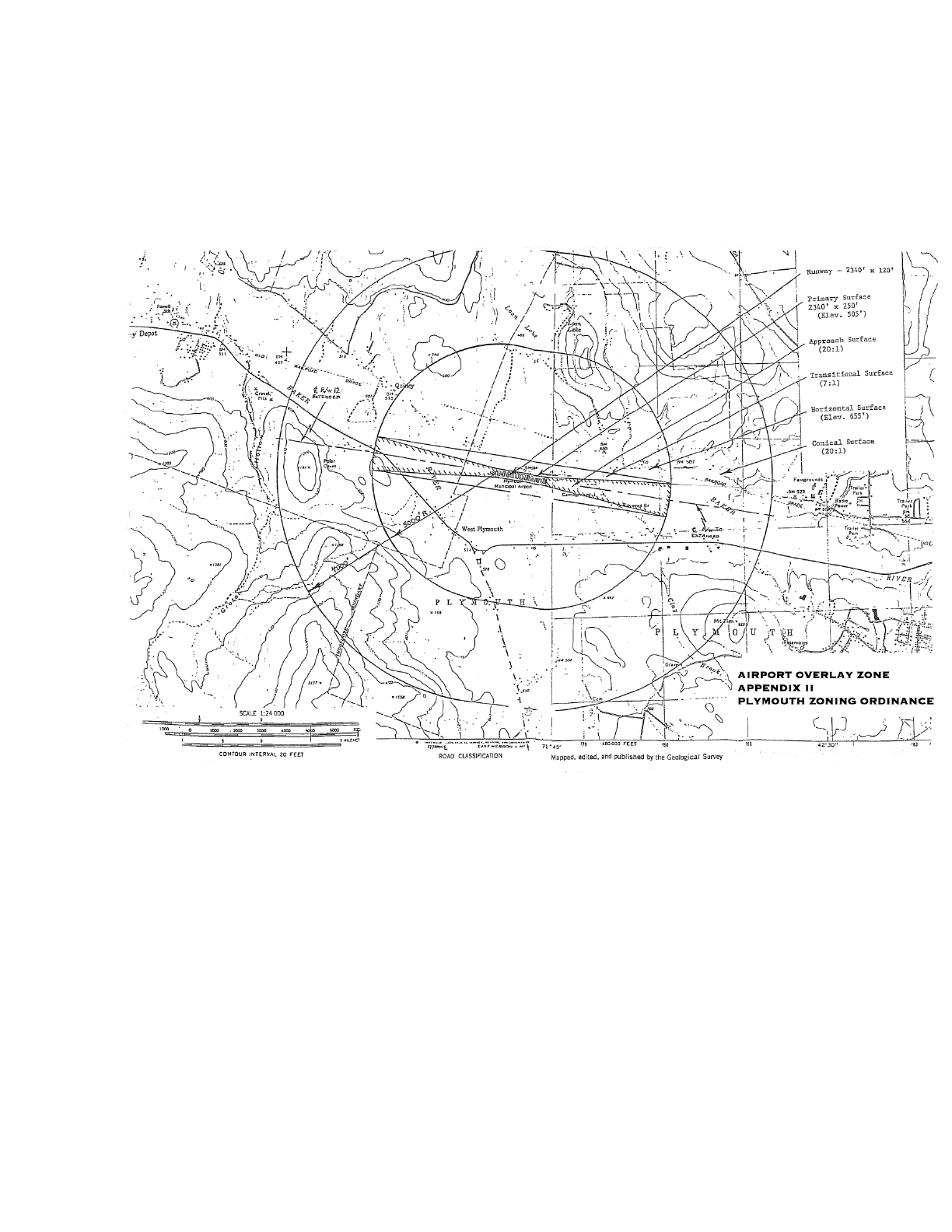
PLYMOUTH, NH ZONING ORDINANCE - MARCH 12, 2024
Page 70
Plymouth Zoning Ordinance, Appendix II
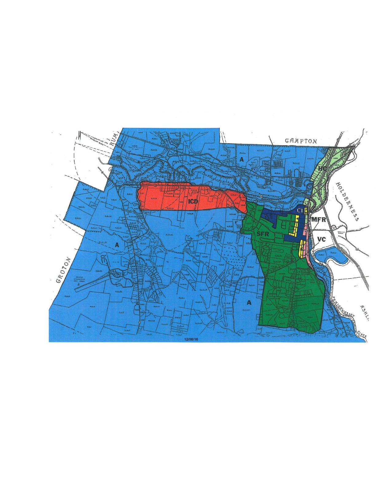
PLYMOUTH, NH ZONING ORDINANCE - MARCH 12, 2024
Page 71
Plymouth Zoning Ordinance, Appendix III
