
FORTH PORTS LIMITED
Document ID
FPS PMSC OP 23_45
Authorised By
HMFT
Original Date
January 2014
Ruling Depths & Under Keel Clearances
Date Revised
June 2023
Revised By
MMT
Review Due
December 2023
- 1 -
Forth Ports Limited
Ruling Depths & Under Keel Clearances - Forth
Vessels are scheduled into / out of ports on the Forth & Tay in accordance with the under keel
clearance criteria specified in this section of the Marine Guidelines & Port Information.
Vessel operators who require increased under keel clearance margins, over and above those published
in the Marine Guidelines & Port Information must ensure that these requirements are specified to
FTNS at the time of booking the vessel’s arrival / departure. This is to ensure that vessels are booked
for the correct height of tide, and to ensure that delays / impacts to the shipping schedule are avoided.
Agents are advised to ascertain vessel specific under keel clear requirements prior to making arrival /
departure bookings through FTNS.
FORTH PORTS LIMITED
Document ID
FPS PMSC OP 23_45
Authorised By
HMFT
Original Date
January 2014
Ruling Depths & Under Keel Clearances
Date Revised
June 2023
Revised By
MMT
Review Due
December 2023
- 2 -
LIST OF AMENDMENTS
July 2018
Update to Container Berth depths following Plough dredge.
July 2018
Berth dimensions for all berths in Leith added, changes to some ruling depths in
Leith & Rosyth
November 2018
Methil depths updates (all depths now in relation to chart datum)
January 2019
Rosyth ruling depths updated and removal of reference to floating fenders on T
Berth
February 2019
Burntisland Key Information
Grangemouth J3 & LPG berth depths updated.
May 2019
Leith approach channel remarks & ruling depths within the port
Burntisland key information and ruling depths
North Imperial cut depth
Grangemouth J3 & LPG berths.
Methil approach.
Rosyth approach
July 2019
Change of UKC for Imperial dock Leith
Grangemouth LPG berth
Grangemouth Grange Dock- North Grange, North & South Tongue
October 2019
New layout to include the reference chart name and date of the survey
Crane pad location added to Rosyth Key information
Rosyth ruling depths updated
January 2020
Rosyth ruling depths updated
March 2020
Inverkeithing Harbour depths updated
April 2020
Grange Dock
Rosyth North Wall
Newhaven Harbour and approaches
August 2020
Grangemouth ruling depth & Rosyth information
December 2020
Rosyth Ruling Depths
Removal of berthing details from Fife ports which have been put in MPGI
document
Kirkcaldy UKC
North Imperial Cut – update regarding vessels with LOA of 111m - 119m
May 2021
Grangemouth Ruling Depths
Leith Ruling Depths
Rosyth Ruling Depths
Methil Energy Park Ruling Depths, Methil Energy Park Key Information
updated
November 2021
Leith Approach and Depths
Grangemouth Depths
Rosyth Depths, Babcock Approach and Depths
Methil Dock Entry and Depths
Kirkcaldy Approach and Depths
December 2021
Babcock Approach and Depths
Methil Approach and Depths
March 2022
Methil Approaches UKC updated
Grangemouth Diversionary Channel included
Rosyth Ruling Depths, Babcock Ruling Depths
April 2022
Grangemouth Approach RD updated
May 2022
Full review of Grangemouth, Rosyth, Inverkeithing, Burntisland, Kirkcaldy, and
Hound Point
July 2022
Rosyth ruling depths, Inverkeithing East Ness note
July 2022
Grangemouth Approach ruling depths, Leith Ruling Depths
October 2022
Leith Locks, Albert Cut and Albert Dock ruling depths updated.
Rosyth approaches, and Babcock ruling depths updated.
Methil Energy Park ruling depths updated.
October 2022
Leith – Albert Cut ruling depth updated
October 2022
Grangemouth – Note added to Grangemouth Approach
October 2022
New row added for Grangemouth Lock ruling depth
Note added to Grangemouth Cill
November 2022
Update to Grangemouth Lock Ruling Depth
November 2022
Grangemouth – Update to Eastern Channel Berths, Grange Dock, Tongue North
& South ruling depths
Rosyth – North Wall & Swing Area Ruling Depths updated
Kirkcaldy – Approaches Ruling Depth updated
Braefoot – West Out Ruling Depth updated.
December 2022
Update to Grangemouth Lock Ruling Depth
Update to Albert & Edinburgh Dock Remarks
Rosyth Ruling Depths
Babcock – Tidal Ruling Depths
Kirkcaldy - Approaches Ruling Depth
Inverkeithing – East Ness Ruling Depth
FORTH PORTS LIMITED
Document ID
FPS PMSC OP 23_45
Authorised By
HMFT
Original Date
January 2014
Ruling Depths & Under Keel Clearances
Date Revised
June 2023
Revised By
MMT
Review Due
December 2023
- 3 -
January 2023
Grangemouth – Update to Eastern Channel Berths
Rosyth approaches, and Babcock ruling depths updated.
March 2023
Grangemouth – Update to Bellmouth, Eastern Channel Jetties and Grange Dock
Berths Ruling Depth
Leith – Update to Albert Cut Ruling Depth
Rosyth – Updates to the Ruling Depths for Rosyth Berths, Approaches & Swing
Area
Inverkeithing Ruling Depths
April 2023
Methil – Update to Ruling Depths
May 2023
Kirkcaldy – Update to Ruling Depths
Rosyth – Update to Ruling Depths
Grangemouth – Update to Eastern Channel, Grange Dock ruling depths.
Leith- Update to Ruling Depths
June 2023
Burntisland – Update to Ruling Depths
Inverkeithing UKC amended
Leith approach channel RD updated
Grangemouth Eastern Channel RDs updated
Methil Energy Park RDs updated
Rosyth RDs updated
FORTH PORTS LIMITED
Document ID
FPS PMSC OP 23_45
Authorised By
HMFT
Original Date
January 2014
Ruling Depths & Under Keel Clearances
Date Revised
June 2023
Revised By
MMT
Review Due
December 2023
- 4 -
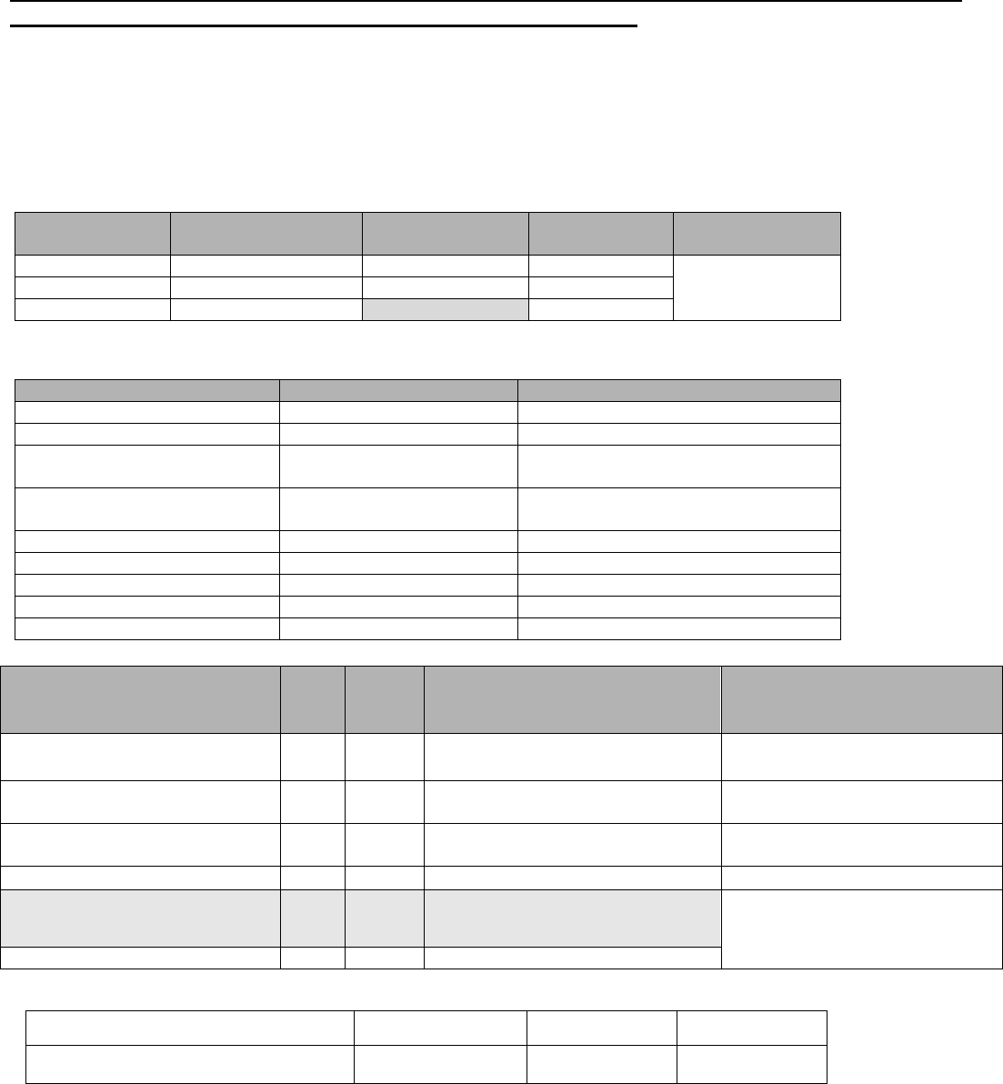
GRANGEMOUTH - RULING DEPTHS AND UNDER KEEL CLEARANCE
Data is based on a broad interpretation of current surveys and is only intended as a general guide.
Original surveys should always be consulted especially for detailed operational planning.
The following Ruling Depths apply to the berths, ports and approach channels. The depths indicated are the
least depth in the channel or on the berth. Deeper water may be available in certain parts of the channel and
conversely shallower water may exist just outside of the channel.
The depths given below are an indication of the least depth, which maybe encountered in the channel,
however a close examination of the latest soundings should be made when preparing a passage plan.
For areas not included in the tables below an under keel clearance of 10% of the vessels maximum
draft with a minimum under keel clearance of 0.5m should be used.
1. Average Grangemouth Dock Density: 1020
2. Maximum Ship size normally accepted at Grangemouth: 187m * 27.4m.
3. All berths in Grange and Carron Dock – average height of quay above waterline 1.0m
4. Outreach of #4 & #5 transporter cranes 34.5m, height from quay to gantry 30m.
Grangemouth Lock Dimensions
Overall length
Chamber Length
Max LOA
Width between
fenders
Outer
108m
90m
82m
29.1m
Inner
129.6m
112m
104m
Full
237.6m
187m
Grangemouth Berth Dimensions
Berth
Length
Remarks
North Grange 1 - 2
170m
North Grange 3 - 7
440m
Distance between #7 and #8 is 84m
Tongue N
Grange 8 - 11
365m
Tongue S
Grange 12 - 15
365m
South Grange
630m
East Wall
215m
East Cut Width
36m
West Cut Width
18.3m
Carron Dry Dock
105m x 16m
Cill 4.8m
Location
UKC
RD
Remarks
Reference
Chart
(Name and date of last survey)
Grangemouth Approach Channel
0.6m
6.2m
Depths of 6.0 metres in the vicinity of
Grangemouth lock entrance.
Grangemouth Bellmouth –
Surveyed Monthly
Grangemouth Diversionary
Channel
0.6m
4.7m
Grangemouth Roads – 15.06.20
Grangemouth Cill
0.6m
6.15 m
The lesser value of the Cill/Lock to
be used for vessel scheduling
Grangemouth Lock
0.6m
5.7 m
Grangemouth Lock – 14.12.22
EASTERN CHANNEL
Depths may be less off the berths – latest
sounding chart to be consulted for vessel
approach and swinging
Eastern Channel – 22.06.23
Common User Oil Jetty (1 North)
0.3m
9.1m

FORTH PORTS LIMITED
Document ID
FPS PMSC OP 23_45
Authorised By
HMFT
Original Date
January 2014
Ruling Depths & Under Keel Clearances
Date Revised
June 2023
Revised By
MMT
Review Due
December 2023
- 5 -
Jetty E 1
0.3m
11.5m
Daughter vessel operations – depth
10.3m. Max Draft for arrival and
departure at E1 9.8m due to 10.4m
patches in Eastern Channel.
Jetty E 2
0.3m
10.4m
Max Draft for arrival and departure at E2
9.8m due to 10.4m patches in Eastern
Channel.
Jetty J 2
0.3m
10.9m
Max Draft for arrival and departure at J2
9.8m due to 10.4m patches in Eastern
Channel.
Jetty J 3
0.3m
10.5m
Max Draft for arrival and departure at J2
9.8m due to 10.4m patches in Eastern
Channel.
Jetty J 4
0.3m
7.5m
Shallows towards the SW in the vicinity
of Jetty 5.
EOL LPG Berth
0.3m
8.2 m
East Cut
Width = 36 metres
0.5m
8.2m
NB maximum draft for Grange Dock
determined by RD at East Cut
GRANGE DOCK
Grange Dock – 18.05.23
North
Grange 1-2 knuckle (Bollard 16-
22)
0.3m
7.1 m
Grange 3 (13-16 Bollard)
0.3m
6.9m
Grange 3-6 (5-13 Bollard)
0.3m
7.3m
(Bollards 8 & 9 Missing/Out of Use)
6.9m on approach to berth – South of
bollard 16
Grange 7 (2-5 Bollard)
0.3m
7.1m
6.9m on approach to berth – South of
bollard 16
Tongue North
Grange 8 (2-6 Bollard)
0.3m
7.1m
Grange 8-9 (6-10 Bollard)
0.3m
6.8m
Depth of 6.2m between bollards 9
and 10, 5m off quay.
Grange 10-11 (10-16 Bollard)
0.3m
6.9m
Tongue South
Grange 15 (1-5 Bollard)
0.3m
7.3m
(Bollard 5,7 & 11 Missing/Out of
Use). Vessels required to use fenders
Grange 14 -12 (5-13 Bollard)
0.3m
7.1m
South
1 – 3 Bollard
0.3m
7.1m
Max Draft – 6.8m
3 – 6 Bollard
0.3m
7.4m
Max Draft – 7.1m
6 – 21 Bollard
0.3m
8.1m
Max Draft – 7.7m (dictated by max
draft able to pass through the East
Cut)
East Wall
1-8 Bollard
0.3m
7.5m
Max Draft – 7.1m
Western Channel
Maximum ship normally 90m *
14m
0.5m
6.4m
Deepest water at centre of channel,
shallows to north and south.
West Cut
Width = 18.3m
Maximum ship normally 90m *
14m
0.5m
7.4m
For vessels which exceed max. ship
dimensions and for dead ship
movements detailed planning is
required including consultation
between Duty Assistant
Harbourmaster and Duty Pilot
Western Channel –
04.10.22
CARRON DOCK
North
Carron Dock –04.10.22
Rankins - no commercial traffic
N/A
Shallows at west end of berth
Amsterdam - no commercial traffic
N/A
Curries - no commercial traffic
0.3m
N/A
Stevens
0.3m
6.8m
Shallower to south of berth.
Cross Berth
0.3m
6.3m
(Between West Cut and Drydock)
South
Conveyor & Old Hoist
0.3m
6.6m
Watsons Lower
0.3m
6.6m
Watsons Middle
0.3m
6.0m
Watsons Upper
0.3m
5.0m
Not in use
New Quay Wall Lower - Tug Berth
0.3m
5.8m
FORTH PORTS LIMITED
Document ID
FPS PMSC OP 23_45
Authorised By
HMFT
Original Date
January 2014
Ruling Depths & Under Keel Clearances
Date Revised
June 2023
Revised By
MMT
Review Due
December 2023
- 6 -
New Quay Wall Upper
0.3m
4.6m
Shallows to west of berth uncharted.
FORTH PORTS LIMITED
Document ID
FPS PMSC OP 23_45
Authorised By
HMFT
Original Date
January 2014
Ruling Depths & Under Keel Clearances
Date Revised
June 2023
Revised By
MMT
Review Due
December 2023
- 7 -
LEITH - RULING DEPTHS AND UNDER KEEL CLEARANCE
The following Ruling Depths apply to the berths, ports and approach channels. The depths indicated are the
least depth which maybe encountered in the channel or on the berth. Deeper water may be available in
certain parts of the channel and conversely shallower water may exist just outside of the channel. A close
examination of the latest soundings should be made when preparing a passage plan.
For areas not included in the tables below an under keel clearance of 10% of the vessels maximum
draft with a minimum under keel clearance of 0.5m should be used.
1. Data based on a broad interpretation of current surveys and is only intended as a general guide
2. Original surveys should always be consulted; especially for detailed operational planning
3. All Depths quoted are in metres
Leith Key Information
Average Dock Density: 1010 (Brackish, dependant on rain fall vs impounding)
Maximum size ship normally accepted at Leith 210m x 30m. Vessels out with these dimensions
will be dealt with on a case-by-case basis.
Lockside is approximately 2m above MHWS.
Quaysides are approximately 2.2m above dock level and 1.5m at OT the Cruise Liner Berth.
Leith Lock Dimensions
Leith Dock General Dimensions
Overall length
Max LOA
Width between fenders
Short Lock
92m
85m
31.6m
Intermediate
159m
150m
Full
259m
210m
Berth
Length
Remarks
Imperial Cut
Entrance width 31.6m
Albert Cut
Entrance width 18.2m
Edinburgh Cut
Entrance width 18.2m
Cruise Liner Berth
375m
Ocean Terminal
175m
Length of usable quayside ahead of Britannia
West Wall
220m
Ranks
150m
North Imperial
570m
1-4 South Imperial
315m
5-6 South Imperial
230m
6 Harbour
150m
8 – 12 Harbour
305m
North Side Albert
300m
4 Albert Cross Berth
85m
North Edinburgh
440m
10-13 Edinburgh
290m
2 Edinburgh
130m
1 Edinburgh
85m
Imperial Dry Dock
167.6 x 21.3 x 7.3m
Edinburgh Dry Dock
91.4 x 12.2 x 5.6m

FORTH PORTS LIMITED
Document ID
FPS PMSC OP 23_45
Authorised By
HMFT
Original Date
January 2014
Ruling Depths & Under Keel Clearances
Date Revised
June 2023
Revised By
MMT
Review Due
December 2023
- 8 -
Caution: this table is a general summary only. Original sounding surveys are to be consulted for navigation and
passage planning.
Location
UKC
RD
Remarks
Reference
Chart
(Name and date of
last survey)
Port of Leith
Sill height 6.71m below ACD
Leith Approach Channel
1.0m
Flood
1.5m
Ebb
6.1m
Ruling depth of Lock = 6.4m
Leith Approach Channel –
20.06.2023
Leith Locks – 13.05.2023
All Berths except North
Imperial
0.5m
North Imperial
0.4m
With prior agreement from the vessel
Outer Harbour
Common User Oil Jetty
9.0m
Alongside timber structure, otherwise 9.8m.
Depths reduce to 8.2m towards Old Imperial
Passage.
Useable Quay 150m from East End. Max
LOA – 120m
Western Harbour –
28.06.2022
Western Harbour
10.1m
Area South east of West Wall to corner of
Ranks and CLB
6.5 to
7.2m
Area South of the two Red Buoys
West Wall
7.7m
Cruise Liner Berth
(Ocean Quay)
10.1m
Reduces 30m from east end
Ocean Terminal
6.5m
Ranks Berth
8.3m
No vehicles allowed on wharf.
Max Beam = 25m
Consult survey chart before berthing on
Ranks Berth
Imperial Dock
Imperial Passage
10.2m
Consult survey chart before berthing in
the Imperial Passage.
Imperial Dock – 29.06.2022
North Imperial Cut
(Yellow Cranes/ Old Lock)
7.7m
Gantry Clearance 20m (boom down)
Maximum length of vessel normally permitted
= 110m.
Vessels with LOA of 111m - 119m with
Harbour Master’s approval.
Width = 20.3m, Beam = 19m.
NOTE: Gate protruding no exit into Western
Harbour
Imperial Dock North
9.4m
Shallows of 9.3m 40m from dry dock
Consult latest sounding chart
7 North Imperial
9.5m
Consult latest sounding chart
South Imperial (1-2)
9.3m
9.1m West of bollard 75, Consult
Sounding Chart
South Imperial (3-4)
9.4m
Shallows to 8.4m at extreme eastern end
of berth
South Imperial 5
9.1m
South Imperial 6
8.8m
Cross Berth
8.7m
8.5m patch at Southern End
Consult survey chart before berthing in
the Cross Berth

FORTH PORTS LIMITED
Document ID
FPS PMSC OP 23_45
Authorised By
HMFT
Original Date
January 2014
Ruling Depths & Under Keel Clearances
Date Revised
June 2023
Revised By
MMT
Review Due
December 2023
- 9 -
Harbour Berths
Fenders required for deep draft vessels.
Head Office Pontoon
2.5m
Imperial Dock – 13.05.2023
6 Harbour
7.5m
8 Harbour
9.3m
10 Harbour
9.5m
12 Harbour
9.5m
Albert Dock
Albert Cut
7.1m
Reference Imperial Dock Chart
27.01.2023
Albert Dock North –
(Measured from East to West)
0m – 230m
230m – West End
7.8m*
7.4m*
*Max sailing / berthing draft as per Albert Cut
ruling depth
Shallows to 7.0m at extreme eastern end
Shallow to 6.3m at extreme west end
Albert Dock – 27.10.2022
Albert Dock East
Wall/Cross Berth
7.0m*
*Max sailing / berthing draft as per Albert Cut
ruling depth
Shoaling in Extreme SE corner approx.
15m from south side
Edinburgh Dock
1 Edinburgh (90m)
6.8m*
*Max sailing / berthing draft as per Albert Cut
ruling depth
2 Edinburgh (145m)
7.3m*
*Max sailing / berthing draft as per Albert Cut
ruling depth
Max LOA = 100m
Shallows at east end
Edinburgh Dock
– 29.06.2022
3 Edinburgh (80m)
6.8m*
*Max sailing / berthing draft as per Albert Cut
ruling depth
Edinburgh Dock South
Arm – (280m)
10 to 11 Edinburgh
12 to 13 Edinburgh
7.6m*
7.4m*
*Max sailing / berthing draft as per Albert Cut
ruling depth
Max LOA = 100m
Edinburgh Dock North
Arm (440m)
7.2m*
*Max sailing / berthing draft as per Albert Cut
ruling depth
Shallows to 6.8m , 30m from East End
Consult latest sounding chart
FORTH PORTS LIMITED
Document ID
FPS PMSC OP 23_45
Authorised By
HMFT
Original Date
January 2014
Ruling Depths & Under Keel Clearances
Date Revised
June 2023
Revised By
MMT
Review Due
December 2023
- 10 -
ROSYTH & FIFE PORTS – RULING DEPTHS AND UNDER KEEL CLEARANCE
The following Ruling Depths apply to the berths, ports and approach channels. The depths indicated are the
least depth in the channel or on the berth. Deeper water may be available in certain parts of the channel and
conversely shallower water may exist just outside of the channel. A close examination of the latest
soundings should be made when preparing a passage plan.
For areas not included in the tables below an under keel clearance of 10% of the vessels maximum
draft with a minimum under keel clearance of 0.5m should be used.
1. Data based on a broad interpretation of current surveys and is only intended as a general guide
2. Original surveys should always be consulted; especially for detailed operational planning
3. All Depths quoted are in metres.
Rosyth
Rosyth Key Information
Height of quayside above CD is 7.522m
Maximum length normally accepted at the North Wall is 250m. Vessels out with these dimensions,
and for all other berths, will be dealt with on a case-by-case basis.
Rosyth traffic is subject to airdraft restrictions due to the Forth Bridges. Ref: Marine Procedure,
Guidelines and Information section 1.1
North Wall strengthened quay 200-400m marks – operating area for the Liebherr crane
Caution: this table is a general summary only. Original sounding surveys are to be consulted for navigation and
passage planning.
Berth
Length
Remarks
North Wall
540m
450m fendered at 15m intervals from the west end.
White rectangle painted at 530m mark.
Berth Box = 35m wide.
T Berth
220m
Ferry berth with Links-span
143m of quayside ahead of the linkspan
Fixed Fenders – Protrude 3.7m to seaward and 2m
above quayside.
S
160m
R
170m
Q
150m
P
150m
Small pontoon in NE corner
O
170m
Location
UKC
RD
Remarks
Reference Chart
(Name and date of last survey)
Rosyth Approach
Channel
0.5m
7.8m
Shallows in vicinity of No.5 buoy
Rosyth Approaches – 27.06.23
Port of Rosyth – 27.06.23
Rosyth Swing Area
0.5m
7.8m
Port of Rosyth – 27.06.23
Port of Rosyth
North Wall
0-30m
30-40m
40-60m
60-210m
210-225m
225-520m
520-535m
535-550m
0.5m
3.3m
8.0m
9.0m
9.1m
9.0m
9.1m
7.4m
5.0m
White rectangle at 530m.
8.9m high spot around 160m mark
Port of Rosyth – 27.06.23
T Berth
20m -S.Dolphin
7.6m
7.4m in approaches - Shallows
towards South of dolphin –
shallows towards the RoRo

FORTH PORTS LIMITED
Document ID
FPS PMSC OP 23_45
Authorised By
HMFT
Original Date
January 2014
Ruling Depths & Under Keel Clearances
Date Revised
June 2023
Revised By
MMT
Review Due
December 2023
- 11 -
pontoon.
S Berth
2.2m
2.0m on approach – shallows
towards North of berth
Approaches to OPQR berths
2.6m
Shallows in vicinity of No.5a Buoy,
and to west of approaches.
O Berth
3.7m
Shallows North of berth – always
consult latest sounding chart
P Berth
2.9m
Shallows north of berth – consult
latest sounding chart
Q Berth
4.0m
R Berth
4.5m
Shallows towards South of berth
Babcock
Babcock – consult H.M
for latest information
0.6m
N.B. UKC for warships = 1.0m.
Non Tidal Basin
9.7m
Basin maintained CD + 4.2m.
Main Basin – 08.01.19
Middle Jetty N
3.1m
Depths vary, check chart. Shallows
to West
Port of Rosyth – 27.06.23
Middle Jetty S
6.2m
Depths vary, check chart. Shallows
to West
South Arm
7.1m
Fenders required to find deepest
water in dredged box - Depths vary,
check chart. Shallows to West
Approaches to Direct
Entrance
6.2m
Approaches to the lock
4.9m
Sills (Lock and Direct
Entrance)
6.57m

FORTH PORTS LIMITED
Document ID
FPS PMSC OP 23_45
Authorised By
HMFT
Original Date
January 2014
Ruling Depths & Under Keel Clearances
Date Revised
June 2023
Revised By
MMT
Review Due
December 2023
- 12 -
Burntisland
Burntisland Key Information
Entrance to harbour between breakwaters is 76m wide.
Maximum size ship normally accepted at the East Dock 100m x 16m. Vessels out with these
dimensions will be dealt with on a case-by-case basis.
Maximum size ship normally accepted at the West dock 100m x 27m.
An estimated water loss of up to 1m per tide can be experienced in the East dock while the West
dock can lose up to 0.5m per tide.
West dock based on an impounded dock height of 4.48m
Caution: this table is a general summary only. Original sounding surveys are to be consulted for navigation and passage
planning.
Location
UKC
RD
Remarks
Reference
Chart
(Name and date of last survey)
Burntisland
Outer Approaches
0.5m
3.3m
Dock approaches less.
Burntisland Approach –
31.05.23
East Dock Approach
2.2m
Consideration to be given to the
shallow water west of the east dock
approach and towards the island jetty
during inclement weather or during
approach manoeuvres
Burntisland Docks – 31.5.23
East Dock
2.1m
Shallows towards the South West
corner of the dock
No1 Berth – West
2.7m
Shallows towards East end of the
berth.
No2 Berth - East
2.6m
Shallows towards East end of the
dock
West Dock Approach
-0.9m
West Dock west wall
Shoals 0.6m from quay face fenders
required to remain clear of this
North/East/South wall
Consult sounding chart – area leased
to Briggs marine
Berth
Width
Remarks
Entrance to East Dock
18.2m
Sill height 3.09m below CD – mitre gate.
Entrance to West Dock
29.5m
Sill height 0.81m below CD – folding gate
FORTH PORTS LIMITED
Document ID
FPS PMSC OP 23_45
Authorised By
HMFT
Original Date
January 2014
Ruling Depths & Under Keel Clearances
Date Revised
June 2023
Revised By
MMT
Review Due
December 2023
- 13 -
Methil
Methil Key Information
Main Entrance to No.2 Dock is 15.2m wide
Maximum size vessel normally accepted is 100m x 14.0m beam. Vessels out with these dimensions
will be dealt with on a case-by-case basis.
Dock gates normally open three hours before high water.
An estimated water loss of up to 0.8m per tide can be experienced
Depth over the outer sill (No.2 dock) is 2.6m below chart datum (No.1 dock is 1.22m above the sill
at No.2)
No entry is permitted to No.1 Dock.
Caution: this table is a general summary only. Original sounding surveys are to be consulted for navigation and
passage planning.
Location
UKC
RD
Remarks
Reference Chart
(Name and date of last survey)
Methil Approaches
0.5m
0.8m
Shallows along outer West pier end
Methil Harbour – 15.03.23
Methil Berths (within No.2
dock)
0.5m
No2 dock out with berth
area
1.2m
Methil Harbour – 15.03.23
Cross/Stone Berth
1.3m
#1 (Hard Pad)
1.4m
#2 (Central Farmers)
1.5m
North East Corner
1.6m
#6
1.4m
Berth
Length
Remarks
Number 2 Dock
15.2m wide, sill 2.6m below ACD
Cross berth
85m
No.1 (Hard Pad)
130m
No.2 (Central Farmers)*
82m
NE Corner
213m
Travelling crane
No.6
Distance across dock between Hard Pad and West side is 121m
Distance across dock between Central Farmers and West side is 109m
Number 1 Dock
No entry to No.1 Dock
East side
173m
West side
136 + 58m
South (West)
43m
South (East)
43m
North side
82m
Distance across dock West to East side is 103m
FORTH PORTS LIMITED
Document ID
FPS PMSC OP 23_45
Authorised By
HMFT
Original Date
January 2014
Ruling Depths & Under Keel Clearances
Date Revised
June 2023
Revised By
MMT
Review Due
December 2023
- 14 -
Methil Energy Park
Methil Energy Park Key Information
Berths owned by Scottish Enterprise.
Vessel suitability will be dealt with on a case by case basis.
Berth
Length
Remarks
Quay 1 East
184m
Leased by Harland & Wolff
Quay 2 West
177m
Leased by Cesscon Decom
For further information, please refer to latest edition of Energy Park Fife - Marine Safety
Management System.
Caution: This table is a general summary only. Original sounding surveys are to be consulted for navigation and
passage planning.
Location
UK
C
RD
Remarks
Reference Chart
(Name and date of last survey)
Methil (Energy Park Fife)
Quay 1 (East berth) 0 – 10m
10 – 70m
70 – 130m
130 – 180m
0.5m
1.2m
2.0m
3.0m
4.0m
Fendering may be required.
Distance given from northern
end of Quay 1. Deepest water on
the approaches is to the South
East of the berth.
Methil Energy Park – 24.4.23
Quay 2 (West berth) 30 - 150m
0 – 20m, and 150 – 178m
0.5m
7.0m
*See
remarks
With stand-off fendering of
7.6m. Distance given from
northern end of Quay 2.
Deepest water on the approaches
is to the South East of the berth.
* Dredge box shallows to
southerly and northerly limits of
berth, see sounding chart.
FORTH PORTS LIMITED
Document ID
FPS PMSC OP 23_45
Authorised By
HMFT
Original Date
January 2014
Ruling Depths & Under Keel Clearances
Date Revised
June 2023
Revised By
MMT
Review Due
December 2023
- 15 -
Kirkcaldy
Kirkcaldy Key Information
Main entrance is 15.2m wide.
Sill height 0.65m below Chart datum.
Maximum size vessel normally accepted is 85m x 14m. Vessels out with these dimensions will be
dealt with on a case by case basis.
Port Side is the preferred side alongside at Carrs Milling.
The berth is a NAABSA Berth (Not Always Afloat but Safely Aground).
Lock gates are no longer in use.
Caution: The following table is a general summary only. Original sounding surveys are to be consulted for navigation
and passage planning.
Location
UKC
RD
Remarks
Reference Chart
(Name and date of last survey)
Kirkcaldy
Kirkcaldy Harbour 19.5.23
Approaches
0.5m
-0.1m
Area subject to siltation – latest
sounding chart to be consulted.
Outer Harbour
0.4m
0.2m
Shallows to west – consult latest
sounding chart
Inner Harbour
0.4m
0.0m
Shallows at SW corner – Consult latest
sounding chart
NE Berth
0.4m*
0.3m*
* Vessels usually take bottom and stated to be NAABSA Berth (Not Always Afloat but Safely Aground). by the berth operators –
stated UKC are for berthing operations
Inverkeithing
Inverkeithing Key Information
Berths in Inverkeithing are managed by either RM Recycling or Forth Bridge
Stevedoring Limited.
All berths designated NAABSA by berth operators.
Berth
Length
Remarks
Deepwater Berth
130m
Max vessel length 110m
No 1 Berth
140m
No 2 + No 3 Berths
Berths not used for commercial traffic
Stone Berth (Quarry)
30m
Max LOA 110m
Old Sea Plane Berth
Berth not used for commercial traffic
East Ness Berth
20m
Caution: this table is a general summary only. Original sounding surveys are to be consulted for navigation and passage
planning.
Location
UKC
RD
Remarks
Reference Chart
(Name and date of last survey)
Inverkeithing
Approaches
0.5m
0.4m
Inverkeithing Approach –
08.12.22
Inverkeithing
Deep Water Berth
*0.4m
1.0m
Restricted to 0.3m owing to approaches:
consult chart for depths alongside berth.
Inverkeithing Harbour –
07.02.23
No 1
*0.4m
-2.0m
Shoals 20m north of berth.
Stone Berth (Quarry)
*0.4m
-0.4m
-0.1m in approaches PST preferred.
East Ness Berth
Up to 85m LOA
Up to 90m LOA
*0.4m
-0.3m
-0.4m
FORTH PORTS LIMITED
Document ID
FPS PMSC OP 23_45
Authorised By
HMFT
Original Date
January 2014
Ruling Depths & Under Keel Clearances
Date Revised
June 2023
Revised By
MMT
Review Due
December 2023
- 16 -
* Vessels usually take bottom and stated to be “Not Always Afloat But Safe Aground”
(NAABSA) by the berth operators – stated UKC are for berthing operations.
Hound Point
Location
UKC
RD
Remarks
Reference Chart
(Name and date of last survey)
HP1 and HP2
2.1m
18.5m
See Marine Guidelines & Port Information
for calculating maximum draft.
Hound Point Oil Terminal –
09.12.20
Braefoot
UKC
RD
Remarks
Reference Chart
(Name and date of last survey)
East Out
2.0m
10.0m
See Braefoot Tide tables.
Mortimers Deep – 04.11.21
West Out
2.5m
10.4m
See Braefoot Tide tables.
Crombie
Location
UKC
RD
Remarks
Reference Chart
(Name and date of last survey)
South Jetty
1.0m
12.0m
Reported by DM Crombie
Aspect A7773 DM Crombie –
22.06.21
North Jetty
7.5m
Newhaven
Location
UKC
RD
Remarks
Reference Chart
(Name and date of last survey)
Newhaven Anchorage
0.5m
8.0m
Shallows to SE and NW corners.
Middle Bank to Leith - 24.11.21
Newhaven Approaches
0.3m
0.9m
Area subject to siltation, consult latest
sounding chart
Newhaven – 03.02.23
Newhaven Harbour
0.3m
0.9m
Area subject to siltation, consult latest
sounding chart
