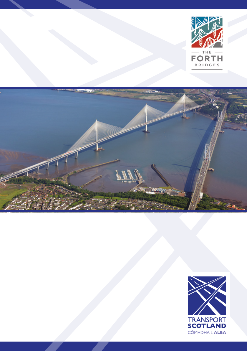
Queensferry Crossing and Forth Road Bridge
Users’ Guide
January 2018
Queensferry Crossing and Forth Road Bridge – Users’ Guide
Forth
Road
Bridge
Forth
Bridge
(Rail)
Queensferry
Crossing
North
Queensferry
Firth
of Forth
Firth
of Forth
Ferrytoll
Junction
Rosyth
Dockyard
& Ferry Terminal
Admiralty
Junction
Rosyth
Dunfermline
Masterton
Junction
Halbeath
Interchange
Crossgates
Junction
Halbeath
Junction
South
Queensferry
Queensferry
Junction
Kirkliston
Newbridge
M9 Junction 1A
M9
M90
(formerly
M9 Spur)
A90 to
Edinburgh
B800
A8
A904
A823 (M)
Inverkeithing
M90
M90
A921
A985
N
M9 to Stirling
A92 to Kirkcaldy
M90 to Perth
to M8 Edinburgh and Glasgow
Legend
Newbridge
Junction
Scotstoun
Junction
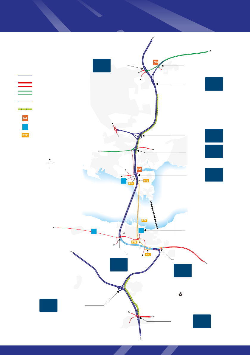
1000
spaces
Contact & Education
Centre
88 spaces
+ 8 bus bays
Dalmeny
1050
spaces
M90
Previously
M90 J1
Winchburgh
A904
Newton
Crossgates
A9000 (previously A90)
Motorway
Other roads
Trunk roads
Special road (A90)
Motorway bus lane (southbound only)*
Park and Ride
Park to view bridges
Public Transport Corridor
access roads
M90
J1B
M90
J2
M90
J2A
M90
J3
P
M90
J1
M9
J1
M9
J1A
M90
J1A
P
200
spaces
P
M90
J1C
8 spaces
P
Edinburgh
Airport
*Further bus lanes on A90, B800, Ferrytoll Junction and
Hope Street omitted for clarity. For Queensferry Crossing
bus lane operation see page 8.
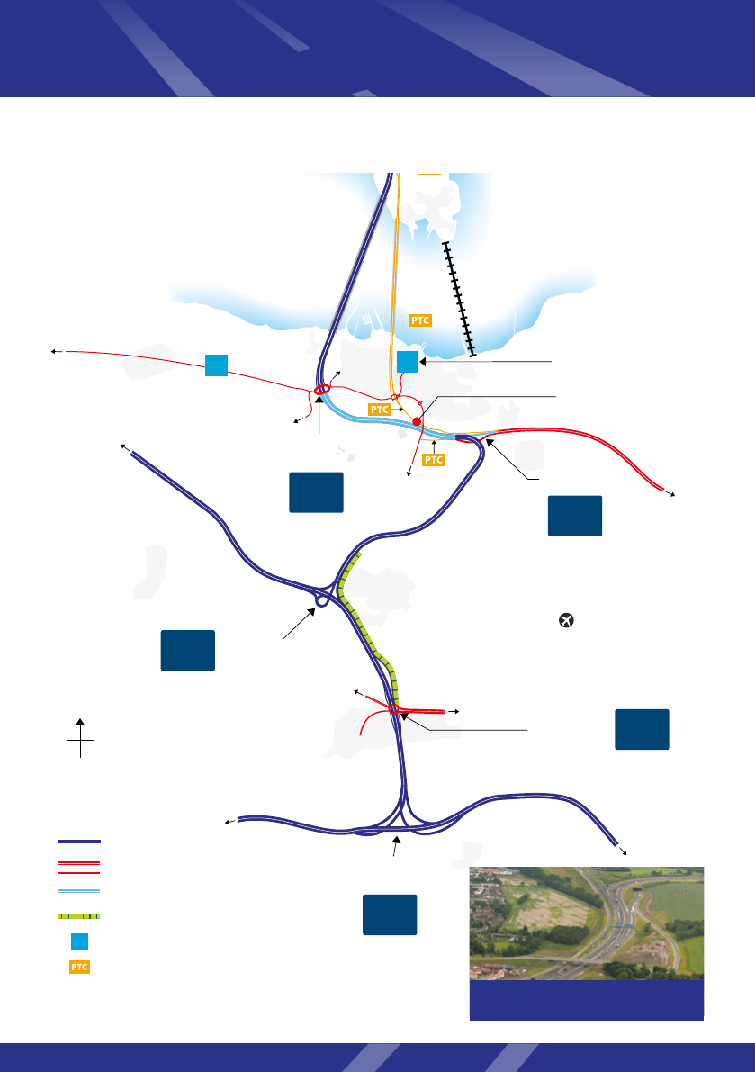
Location plan
2

Introduction
The opening of the Queensferry Crossing provides new opportunities for travel across the Forth, for
all road users including pedestrians and cyclists. To support its opening, a new 13.7mile (22km) long
motorway corridor has also been completed, extending from the M90 Halbeath Junction over the
Queensferry Crossing to the M9 north of Newbridge Junction. Various new and modied junctions
and associated roads have also been constructed, and a number of new road features have been
incorporated. The Forth Road Bridge has now been re-designated primarily for use by public transport.
This guide has been produced for road users of the Queensferry Crossing, Forth Road Bridge and the
surrounding road network to help provide an understanding of the new road and bridge layouts and
their associated features. Although trafc signs provide relevant guidance for the appropriate use of
the bridges and their approach roads, road users may, however, nd this guide of value as it provides:
• A summary of how the motorway and associated roads operate.
• An overview of the access arrangements for the Queensferry Crossing and Forth Road Bridge.
Contents
The Queensferry Crossing and Forth Road Bridge
With the opening of the Queensferry Crossing, the Forth Road Bridge operates as a dedicated Public
Transport Corridor and also offers an improved environment for walkers and cyclists. Details of access
restrictions and sustainable travel choices are included on pages 4 and 5.
Intelligent Transport System (ITS)
ITS technology is employed along the new motorway. It enables implementation of mandatory variable
speed limits and lane controls. In addition, some lengths of hard shoulder are also being used as bus
lanes to help improve bus journey time reliability. Key ITS and roadside features are further explained
on pages 6 to 9.
The road network north and south of the Forth
Changes to the road network have been necessary to accommodate the Queensferry Crossing,
resulting in new or modied motorway, special roads, trunk roads, local roads, cycleways and pathways.
Road designations, access arrangements and key features are further explained on pages
10 to 13.
FAQs
Frequently asked questions are covered on page 14.
Summary
A summary of the key information from this guide is provided on page 15.
Further information and contact details
See back page.
3
Queensferry Crossing and Forth Road Bridge – Users’ Guide
4
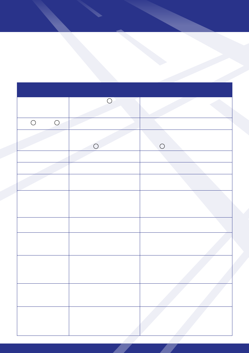
Access restrictions
The following chart summarises the road users authorised to access the Queensferry Crossing
and Forth Road Bridge.
Road user Queensferry Crossing
(M90 Motorway)
Forth Road Bridge
(A9000)
General Trafc
(Cars and HGVs)
✔
Subject to normal motorway
restrictions.
✗
Buses and taxis
✔ ✔
Agricultural Vehicles
✔
Subject to normal motorway
restrictions.
✔
Those not permitted to use the Queensferry
Crossing.
Abnormal Loads
✔ ✗
Emergency vehicles
✔ ✔
Vehicles carrying
corrosive materials
✔ ✗
Motorcycles more than
125cc
✔ ✔
Only learners with a provisional licence
under supervision of a certied direct access
instructor.
Motorcycles of 50cc up
to 125cc
✔ ✔
Including learners.
Motorcycles less than
50cc
✗
Motorcycles less than 50cc are
not permitted on motorways.
✔
Including learners.
Pedestrians and cyclists
✗ ✔
Using the dedicated footway and/or cycleway.
Dog walkers must keep dogs under control
on a lead and remain on the footway.
Learner drivers
cars and motorcycles
✗ ✗
No learner car drivers. See above for
permitted motorcycles.
Horses/horse drawn
vehicles
✗ ✗
There is no access to the footway and
cycleway. Access to the carriageway is only
by prior consent of the roads authority.
1
2 3
4 4
Sustainable travel, including walking and cycling,
is encouraged:
5
The trafc permitted to use motorways is set out in
the Roads (Scotland) Act 1984.
Class 1 – Heavy and light locomotives, motor
tractors, heavy motor cars, motor cars, motor
cycles with engine capacity of not less than 50cc
(which comply with requirements).
Class 11 – Motor vehicles and trailers conveying
abnormal indivisible loads; motor vehicles and
trailers constructed for naval, military, air force or
other defence purposes; and certain construction
and engineering vehicles (which comply with
requirements).
The Class 1 and 11 requirements are detailed at:
www.legislation.gov.uk/ukpga/1984/54/contents
Buses including vehicles carrying more than
8 passengers for hire or reward that fall within the
denition in the Public Passenger Vehicles Act 1981:
www.legislation.gov.uk/ukpga/1981/14/contents
Taxis include private hire vehicles.
Agricultural vehicles include tractors, tractors
towing loaded trailers and other agricultural
vehicles such as combine harvesters (on
trailers or crossing under their own power).
Agricultural vehicles permitted to use the
Queensferry Crossing are covered by Classes
1 or 11 in Schedule 3 of the Roads (Scotland)
Act 1984 and are subject to normal motorway
restrictions: www.legislation.gov.uk/
ukpga/1984/54/contents
Agricultural vehicles are permitted to use the
Forth Road Bridge without the prior consent
of the roads authority if they:
a) are not permitted to use the Queensferry
Crossing; and
b) fall within the denition and provisions
relating to agricultural motor vehicles set out in
section 3 of The Road Vehicles (Construction
and Use) Regulations 1986:
www.legislation.gov.uk/uksi/1986/1078/
contents/made
Agricultural vehicles that do not conform with
The Road Vehicles (Construction and Use)
Regulations 1986 may be permitted to use
the Forth Road Bridge but only with the prior
consent of the roads authority.
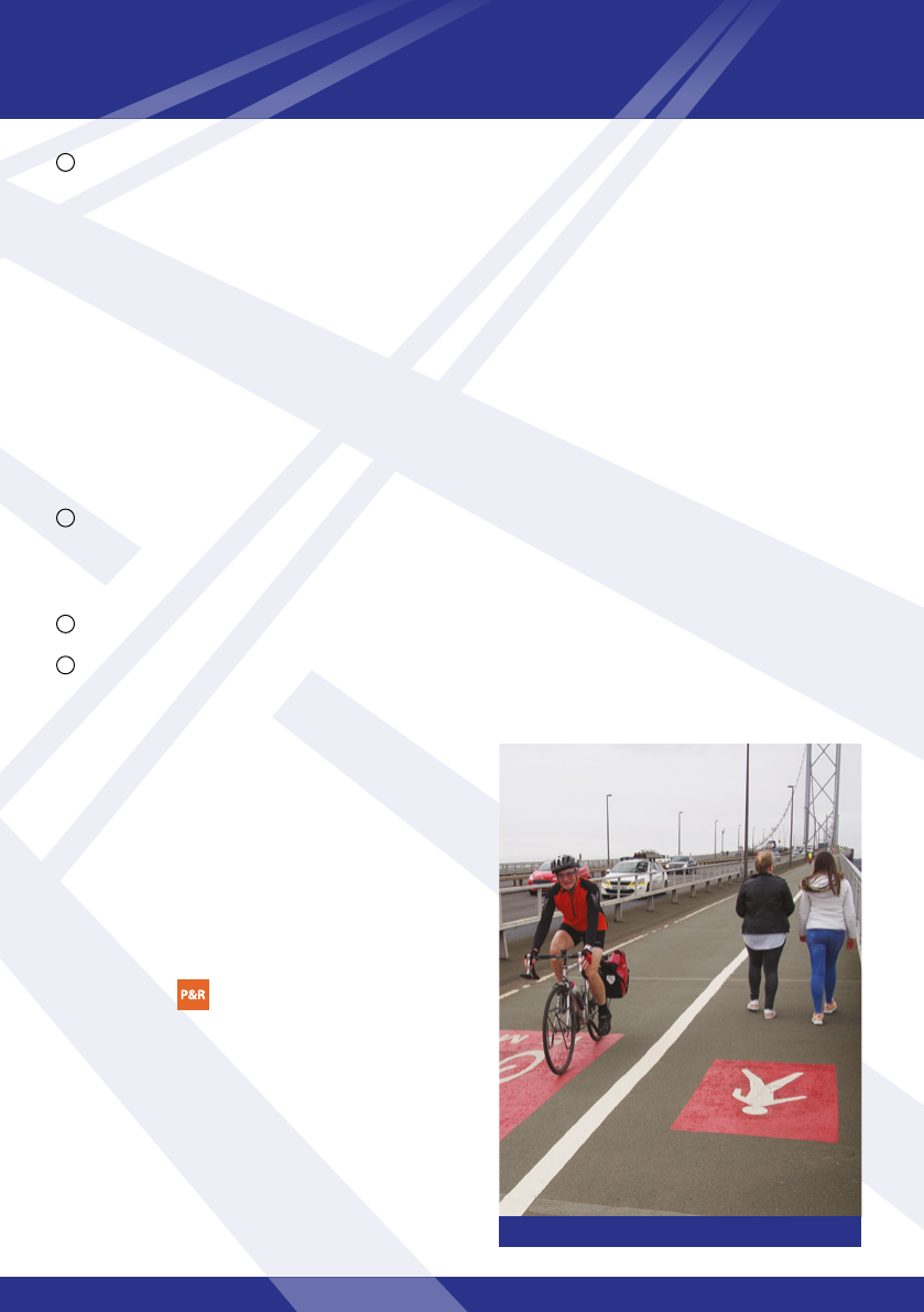
Pedestrians and cyclists on the Forth Road Bridge.
1
2
3
Sustainable travel
• As a Public Transport Corridor, the Forth Road
Bridge combines with adjacent bus priority
measures to provide increased reliability of bus
journey times across the Forth. Details are available
at www.halbeath.org and www.ferrytoll.org
• Park & Ride facilities are available at Halbeath
and Ferrytoll.
• With general trafc removed from the Forth Road
Bridge, the experience for pedestrians and cyclists is
improved. New sections of footpaths, cycleways and
safe crossing points have also been introduced as
part of the changes to the road network.
• Access to the rail network is provided by a number
of stations including Dalmeny, North Queensferry,
Inverkeithing and Rosyth.
4
Queensferry Crossing and Forth Road Bridge – Users’ Guide
6
or
Intelligent Transport System (ITS)
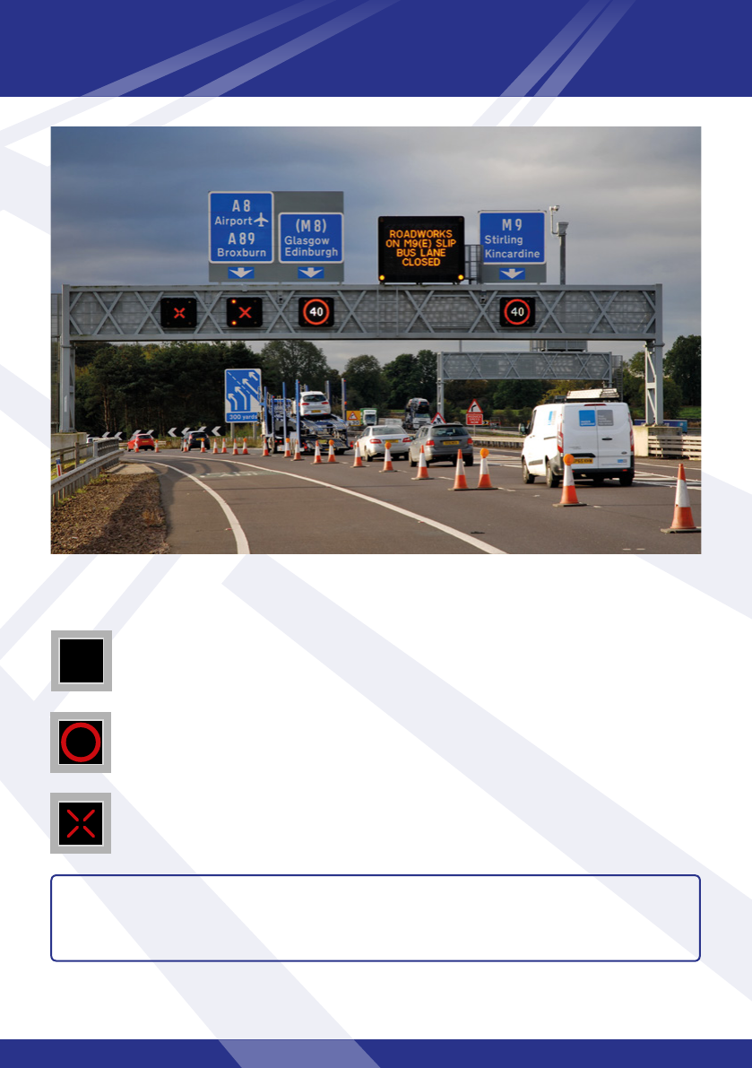
Intelligent Transport System (ITS) technology deployed along the full Queensferry Crossing motorway
corridor provides lane control, mandatory variable speed limit control and bus lane control.
This technology improves trafc ow, reduces congestion and improves road safety. ITS began
operating on some of the roads covered by this guide in 2013, and in the rst three years of operation
accidents reduced substantially – by around two thirds.
Overhead gantries spaced regularly along the route support the ITS equipment including motorway
signals for lane and speed controls, variable message signs, CCTV cameras, journey time cameras and
enforcement cameras including automatic number plate recognition.
Mandatory variable speed limits
ITS allows mandatory variable speed limits to be applied so that vehicle speeds can be managed
during congestion and in response to incidents such as breakdowns.
Variable speed limits keep trafc moving by controlling the ow of vehicles when a road is congested.
Using CCTV cameras and data from trafc ow detectors, Trafc Scotland’s National Control Centre
can monitor trafc levels and lower speed limits to reduce trafc build-up.
Failure to comply with mandatory variable speed limits is a motoring offence.
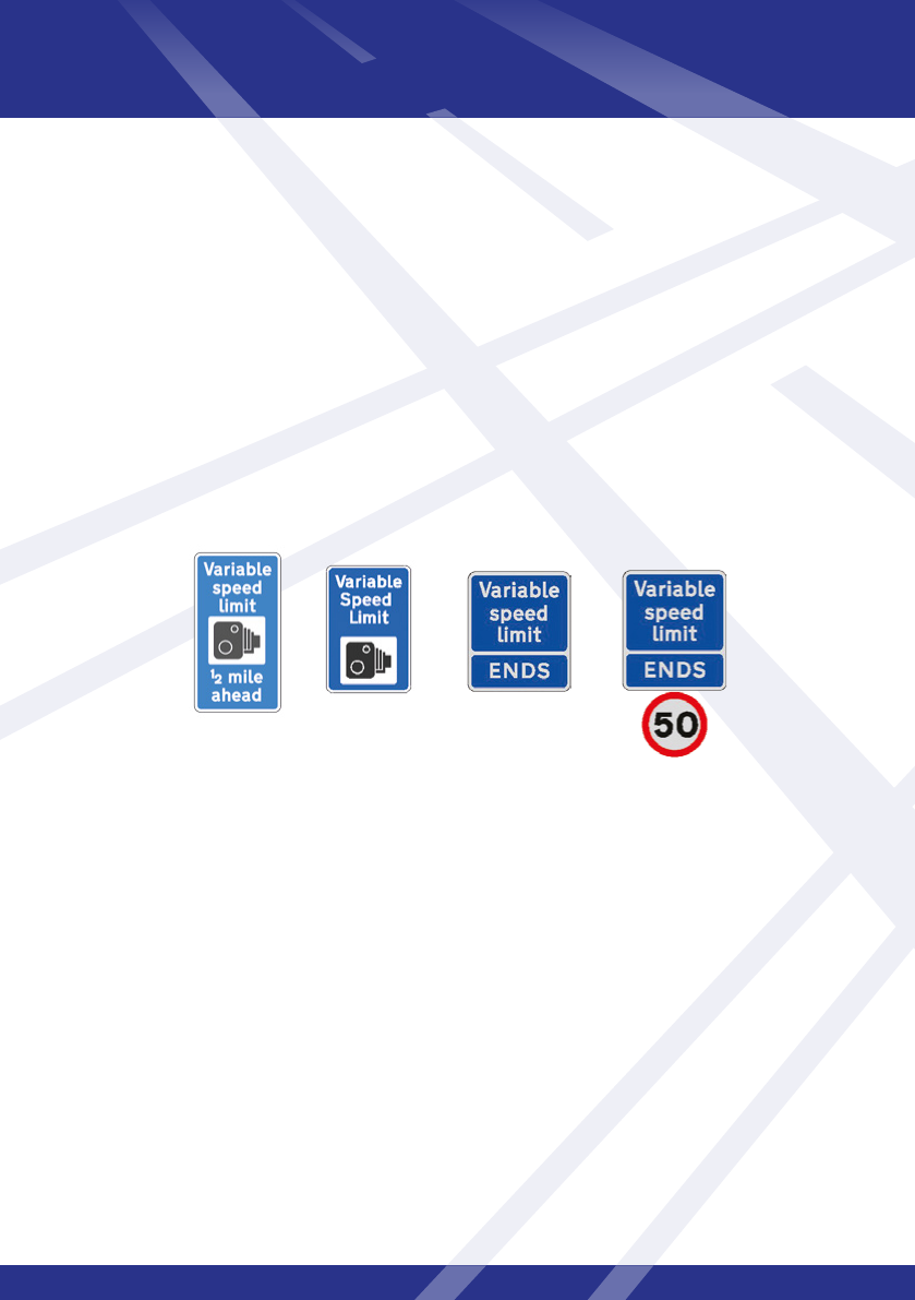
Fixed gateway signs indicate road users are entering or leaving managed motorway.
Entering and leaving the managed motorway
7
50
Speed limit signal
The speed limit displayed is mandatory, is the maximum permitted and will
vary to suit trafc conditions.
NOTE: Other standard motorway signals may also be displayed. For further information,
please refer to the Highway Code – an online version is available at
www.direct.gov.uk
Mandatory variable speed limits are indicated by red rings on gantry signs while variable message signs can
advise drivers of trafc conditions.
Blank signal
Normal motorway rules and speed limits apply.
Red cross
If above a trafc lane, you are not permitted to travel further in that lane. If above
a bus lane/hard shoulder, you may still use this as a hard shoulder in an emergency.

Queensferry Crossing and Forth Road Bridge – Users’ Guide
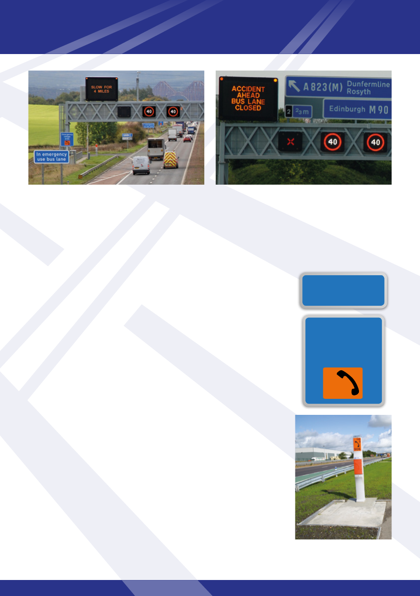
Bus lane/hard shoulder operation
In various locations the hard shoulders have been congured to operate as a bus lane – see section
maps on pages 10 and 12. These locations are indicated by trafc signs.
The use of these bus lanes is legally restricted to buses and coaches that can carry
24 seated passengers or more. Any buses that do not meet this requirement are
prohibited from using these bus lanes.
Intermittent green road surfacing and ‘Bus Lane’ road markings within the hard
shoulder, at the start and end of the bus lane and repeated along its length,
reinforce the presence of the bus lane.
Apart from the hard shoulders on the Queensferry Crossing, these bus lanes/hard shoulders operate
on a 24-hour, 7 days a week basis. The Queensferry Crossing hard shoulders (northbound and
southbound) may be used by buses and coaches when the Forth Road Bridge is closed (e.g. due to
high winds) and when appropriate signs are displayed.
8
Max bus
lane speed
40
24
+
Motorway users should take care at slip roads as buses may carry straight on and re-enter the bus lane
through the green marked section (see above photo). Motorway users must not follow buses through this
restricted section.
Motorway drivers should be aware that buses are likely to use normal trafc lanes during non-congested
periods as they can travel at higher speeds than the advisory 40mph maximum limit applicable to the bus lanes.
9
In case of breakdown or emergency
The bus lane is always accessible as a hard shoulder to any vehicle involved
in a breakdown or emergency. When this happens buses are diverted to
the normal trafc lanes.
In an emergency, one of the emergency refuge areas next to the bus
lane/hard shoulder should be used. These emergency refuge areas have
emergency roadside telephones with a direct connection to the Trafc
Scotland Control Centre whose trained operators will advise and support
you. The telephones are generally positioned behind roadside barriers and
at a height suitable for road users with disabilities.
If you can’t reach an emergency refuge area in your vehicle, the hard
shoulder should be used. Should you require a telephone, follow the
directions on the roadside marker posts.
If you use your mobile to report an emergency, dial 112 or 999 to contact
the emergency services. Always follow the Highway Code directions for
breakdowns and incidents, including additional rules for the motorway
(sections 274 to 287). An online version of the Highway Code is available
at www.direct.gov.uk
In emergency situations, the motorway signal over
the bus lane is used to advise bus drivers that the bus
lane is closed – a red ‘X’ signal is displayed over the
bus lane and the variable message sign reinforces this.
In normal operation, the bus lane is open and is
indicated by a blank signal. Note the presence of an
emergency refuge area.
Emergency
refuge
area
SOS
In emergency
use bus lane
Queensferry Crossing and Forth Road Bridge – Users’ Guide
Queensferry
Crossing
Firth
of Forth
Firth
of Forth
Halbeath
Interchange
Crossgates
Junction
Halbeath
Junction
Queensferry
Junction
M9
M90
(formerly
M9 Spur)
A823 (M)
M90
M90
M9 to Stirling
A92 to
Kirkcaldy
M90 to Perth
to M8
Newbridge
Junction
Scotstoun
Junction
M90
A90 to
Edinburgh
Ferrytoll
Junction
Admiralty
Junction
Masterton
Junction
Previously
M90 J1
M90
J1B
M90
J2
M90
J1C
Pitreavie
Roundabout
Halbeath P&R
1000 spaces
Ferrytoll P&R
Forth
Road
Bridge
Forth
Bridge
(Rail)
North
Queensferry
Rosyth
Dockyard
& Ferry Terminal
Rosyth
Dunfermline
South
Queensferry
Kirkliston
Newbridge
B800
A8
Inverkeithing
A921
A985
Contact & Education
Centre
88 spaces
+ 8 bus bays
Dalmeny
1050 spaces
Winchburgh
Crossgates
A9000 (previously A90)
Emergency Connections
(see page 14, Q3)
200
spaces
(Access from
the B981)
M90
J2A
M90
J3
M90
J1
M9
J1
M90
J1A
P
M9 Junction 1A
M9
J1A
P
P&R
P&R
Edinburgh
Airport
N
A904
A904
Newton
8 spaces
P
North road network
10
Legend
Motorway
Other roads
Trunk roads
Bus lane (southbound only)
Park and Ride
Park to view bridges
Public Transport Corridor
access roads
P
New access to
Ferrytoll P&R
public car park
(1050) spaces
To Inverkeithing
(Hope Street)
New bus only
access to
Ferrytoll P&R
A9000
Public
Transport
Corridor
To North
Queensferry
To Port
of Rosyth
King Malcolm Drive
To Rosyth
To Rosyth
Ferrytoll Road
Castlandhill
Road
Ferrytoll Junction
B981
Ferrytoll overow car park

A number of measures have been implemented north of the Forth to enhance public transport and the
operation of general trafc, including:
Mandatory variable speed limits:
• Southbound from Halbeath (on the M90) and Crossgates (on the A92) towards and over the
Queensferry Crossing.
• Northbound over the Queensferry Crossing to north of Masterton Junction (M90 J2).
• On the A823(M) eastbound from east of Pitreavie roundabout.
Hard shoulders operating full time as permanent bus lanes:
• Southbound from Halbeath Interchange (M90 J2A) to Admiralty Junction (M90 J
1C).
Hard shoulders available as temporary bus lanes when the Forth Road Bridge
is closed:
• On the Queensferry Crossing, buses and coaches carrying 24 seated passengers or more may use
the hard shoulders (northbound and southbound) as bus lanes when the Forth Road Bridge is
closed (e.g. due to high winds) and when appropriate signs are displayed.
Public Transport Corridor and associated facilities:
• Vehicles permitted to use the Forth Road Bridge can use the access roads indicated
by on the map.
• Bus priority lanes are provided at Ferrytoll Junction.
• At Ferrytoll Park & Ride buses and general trafc have separate entry and exit lanes to improve
access and operation.
Facilities for pedestrians and cyclists:
• New footpaths and cycleways have been provided in and around Ferrytoll Junction, linking with
Ferrytoll Park & Ride.
• Cyclists may use the public transport links and roads at Ferrytoll Junction to access the cycleways
on the Forth Road Bridge.
11
The north road network looking south to the bridges.
Queensferry Crossing and Forth Road Bridge – Users’ Guide
Queensferry
Crossing
Firth
of Forth
Firth
of Forth
Halbeath
Interchange
Crossgates
Junction
Halbeath
Junction
Queensferry
Junction
M9
M90
(formerly
M9 Spur)
A823 (M)
M90
M90
M9 to Stirling
A92 to Kirkcaldy
M90 to Perth
M8 to
Edinburgh
Newbridge
Junction
Scotstoun
Junction
M90
A90 to
Edinburgh
Ferrytoll
Junction
Admiralty
Junction
Masterton
Junction
Previously
M90 J1
M90
J1B
M90
J2
M90
J1C
M8 to Glasgow
Ratho
P
Forth
Road
Bridge
Forth
Bridge
(Rail)
North
Queensferry
Rosyth
Dockyard
& Ferry Terminal
Rosyth
Dunfermline
South Queensferry
Kirkliston
Newbridge
B800
A8
A904
Inverkeithing
A921
A985
1000
spaces
Contact & Education Centre
88 spaces + 8 bus bays
1050
spaces
Winchburgh
A904
Newton
Crossgates
8 spaces
Dundas
M90
J2A
M90
J3
M90
J1
M9
J1
M90
J1A
M9 Junction 1A
M9
J1A
P&R
P&R
Claylands
Junction
M8
J2
Edinburgh
Airport
P
N
Emergency Connections
(see page 14, Q3)
Dalmeny
South road network
12
Legend
Motorway
Other roads
Special road (A90)
Bus lane (southbound only)
Park to view bridges
Public Transport Corridor
access roads
P
Scotstoun Junction looking east towards
Dalmeny.
For the south road network, measures implemented to enhance public transport and operation
for general trafc include:
Mandatory variable speed limits:
• On the Queensferry Crossing – both carriageways (northbound and southbound) through
the Scotstoun Junction (M90 J
1) to M9 Junction 1A.
• On the M9 southbound between Winchburgh and Newbridge.
Hard shoulders operating as full time bus lanes:
• Southbound from the M90 (at Kirkliston) to Newbridge Junction (M9 J
1).
Hard shoulders available as temporary bus lanes when the Forth Road
Bridge is closed:
• As north road network, see page
11.
Special road restrictions:
• To minimise diversion of non-motorway trafc onto the local road network in the South
Queensferry area, the approach road (A90) between Queensferry Junction (M90 J
1A) and
Scotstoun Junction (M90 J
1) has been designated "special road". Trafc permitted to use this
road includes Class 1, Class 11 and Class 1V vehicles as set out in the Roads (Scotland) Act
1984 – see www.legislation.gov.uk/ukpga/1984/54/contents. This means that while the
majority of motor vehicles can use this road; pedestrians, cyclists, motorcycles less than 50cc
and other classes of non-motorised vehicles are restricted.
Public Transport Corridor and associated facilities:
• Vehicles permitted to use the Forth Road Bridge can use the access roads indicated
by on the map.
• Bus priority lanes are provided on the B800 to assist northbound bus movements between
the A90 and the Forth Road Bridge.
13
Facilities for pedestrians and cyclists:
• New and enhanced facilities for pedestrians and cyclists have
been provided at the A904 around Queensferry Junction and
on a section of the B800 from Dundas northwards.
• Cyclists are permitted to use the bus lanes on the B800.
• A footway/cycleway in Echline Fields passes under the
Queensferry Crossing to provide an alternative rural means
of crossing the M90 in the vicinity of the Queensferry Junction.
• Information regarding pedestrian and cycling facilities is provided
in the 'Forth Road Bridge – Walking and Cycling Guide'.
Queensferry Junction looking north to
Echline Fields.

Queensferry Crossing and Forth Road Bridge – Users’ Guide
14
Frequently asked questions
Q – If the Forth Road Bridge is closed due to high winds won’t the Queensferry Crossing
also need to close?
A – As the Queensferry Crossing incorporates advanced windshielding technology, it can remain open
during much higher wind speeds than the Forth Road Bridge. Variable message signs will display any
restrictions resulting from adverse weather or an incident.
Q – Are all buses allowed to use the Forth Road Bridge and hard shoulder bus lanes?
A – Buses and coaches that carry more than 8 passengers for hire or reward can use the Forth Road
Bridge – see pages 4 and 5. The use of hard shoulder bus lanes is legally restricted to buses and
coaches that can carry 24 seated passengers or more – see page 8.
Q – If there is an incident on the Queensferry Crossing, such as a road trafc accident,
will trafc be allowed to use the Forth Road Bridge?
A – Subject to the type and likely duration of the incident, the road operating company, in conjunction
with the police, can agree to activate emergency connections to divert trafc via the Forth Road Bridge
– see maps on pages 10 and 12.
Q – If congestion continues in the area will you consider opening up the Forth Road Bridge
to general trafc?
A – The Queensferry Crossing replaces, but does not increase, the road provision for general trafc across the
Firth of Forth. It is not Scottish Government policy to provide for unconstrained growth in vehicle trafc and
to attempt to do so would be unsustainable. Any increase in demand will need to be met by public transport
and walking/cycling.
Q – Is it safe to have any trafc on the Forth Road Bridge given the issues with the main cables
and the truss end links?
A – Yes, it is safe. Monitoring of the Forth Road Bridge is on-going and indicates that it is continuing to
perform acceptably. In addition, retaining limited use of the Forth Road Bridge as a Public Transport
Corridor will remove the heavy trafc loading on it, thus helping to extend its operational life.
Q – Where is the best place to stop to view the Queensferry Crossing and Forth Road Bridge?
A – The Queensferry Crossing and its approaches will be motorway (M90) and, therefore, it will not be
possible to stop on the crossing or its approaches. The nearest car parks to the Queensferry Crossing are
situated at the Contact & Education Centre (CEC), the Fife Council car park (which is accessed off the
B981) and a layby on the A904 east of Newton. These parking places are marked on the map on page 2.
There is a public walkway on the Forth Road Bridge and a viewing platform at the CEC.
Q – Previous information I have seen refers to a "managed crossing strategy", what is this?
A – This guide summarises the managed crossing strategy. The term "managed" indicates that the bridges
and surrounding road network have been designed to cater for all travel modes by making the most
appropriate use of existing and new infrastructure.

15
Summary
• The Queensferry Crossing is a motorway (M90).
• The Forth Road Bridge forms part of a Public Transport Corridor restricted to certain
users including buses, taxis, motorcycles (up to 125cc), pedestrians and cyclists.
• Trafc signs provide relevant guidance for the appropriate use of the bridges and their
approach roads.
• An Intelligent Transport System (ITS) is in operation and includes overhead gantries,
spaced regularly along the route. These include motorway signals and variable
message signs to control trafc and inform road users. Mandatory variable speed limits
are applied when necessary – e.g. during incidents or when signicant congestion
occurs.
• Intelligent Transport Systems increase the efciency and capacity of roads by
improving trafc ow and reducing congestion, in turn helping journey time reliability,
reducing emissions and improving safety.
• Road signs indicate where lengths of hard shoulder can be used as permanent bus
lanes. When the Forth Road Bridge is closed and appropriate signage is displayed, the
Queensferry Crossing hard shoulders can also be used as bus lanes.
• Road users should use the hard shoulder in an emergency. If this is being used as a bus
lane, ITS will divert buses to the normal trafc lanes.
Three bridges from three centuries (l to r): the Queensferry Crossing, Forth Road Bridge and Forth Bridge (rail).

16
Contacts
Trafc and Roads
Up-to-date information for road users on Scotland’s motorway and trunk road
network is available on Trafc Scotland www.trafcscotland.org or on the
move via its mobile website m.trafcscotland.org. The website also provides
details of other information services including Trafc Scotland Internet Radio,
Twitter account and smartphone apps.
Further Information
Forth Bridges Forum
A partnership of major public
sector bodies committed to
the successful management
and promotion of the Forth
Bridge, Forth Road Bridge and
Queensferry Crossing.
Trunk Roads Authority
Transport Scotland
Buchanan House
58 Port Dundas Road
Glasgow
G4 0HF
Telephone: 0141 272 7100
Email: [email protected]
Website: www.transport.gov.scot
Transport Scotland is an agency of Scottish Ministers
Trunk Road Operating Company – Forth Bridges
Amey
Administration Ofce
South Queensferry
West Lothian
EH30 9SF
Telephone: 0800 042 0
188
Email: [email protected]
Website: www.forthroadbridge.org
Tripshare
Supported by SEStran
and Liftshare, a website
promoting car sharing
by helping nd travel
matches.
Website: www.tripsharesestran.com
Traveline Scotland
A partnership of transport
companies, local authorities and
passenger groups providing up
to date travel information to
help plan your journey.
Website: www.forth-bridges.co.uk
Website: www.travelinescotland.com
Queensferry Crossing
ARC
Discover the Queensferry
Crossing's construction story
through 3D animations, videos
and an archive of on-site
photography and articles.
Website: www.queensferrycrossingarc.co.uk
