Posted on Authorea 25 Mar 2021 — The copyright holder is the author/funder. All rights reserved. No reuse without permission. — https://doi.org/10.22541/au.161670433.32615835/v1 — This a preprint and has not been peer reviewed. Data may be preliminary.
STEM Lesson: The Underground Railroad and US Landforms.
Diana Rosado Jim´enez
1
1
Affiliation not available
March 25, 2021
U.S Landforms and the Underground Railroad.
Suggested Time: 180 Minutes
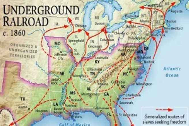
Figure 1: Map of the Underground Railroad
Overview:
Mountains are important structures of the North American landscape. By studying the types of mountains,
scientists can figure out what processes have shaped the continent over the last several hundred million years.
The North American landforms played an important role in the Underground Railroad, slaves had to know
the land and the challenges it presented to be able to pass undetected through the continent of the U.S.
N.G.S.S. Standards:
• MS-ESS2-1 Develop a model to describe the cycling of Earth’s materials and the flow of energy that
drives the process.
• MS-ESS2-2 Construct an explanation based on evidence for how geoscience processes have changed
Earth’s surface at varying time and spatial scales.
1
Posted on Authorea 25 Mar 2021 — The copyright holder is the author/funder. All rights reserved. No reuse without permission. — https://doi.org/10.22541/au.161670433.32615835/v1 — This a preprint and has not been peer reviewed. Data may be preliminary.
• MS-ESS2-3 Analyze and interpret data on the distribution of fossils and rocks, continental shapes, and
seafloor structures to provide evidence of the past plate motions
NCSS Themes:
I. Time, Continuity and Change III. People, Places, and Environments IV. Individual Development and
Identity V. Individuals, Groups and Institutions VIII. Science, Technology, and Society IX. Global Connec-
tions
C.C.S.S. Standards History and Social Studies:
CCSS.ELA-LITERACY.RH.6-8.1 CCSS.ELA-LITERACY.RH.6-8.2 CCSS.ELA-LITERACY.RH.6-8.3
CCSS.ELA-LITERACY.RH.6-8.4 CCSS.ELA-LITERACY.RH.6-8.5 CCSS.ELA-LITERACY.RH.6-8.6
CCSS.ELA-LITERACY.RH.6-8.7 CCSS.ELA-LITERACY.RH.6-8.8 CCSS.ELA-LITERACY.RH.6-8.9
CCSS.ELA-LITERACY.RH.6-8.10
N.Y. Social Studies Framework Standards:
7.7 REFORM MOVEMENTS: Social, political, and economic inequalities sparked various reform movements
and resistance efforts. Influenced by the Second Great Awakening, New York State played a key role in major
reform efforts. (Standards: 1, 5; Themes: SOC, CIV, GOV) 7.7a The Second Great Awakening, which had
a strong showing in New York State, inspired reform movements. 7.7b Enslaved African Americans resisted
slavery in various ways in the 19th century. The abolitionist movement also worked to raise awareness of and
generate resistance to the institution of slavery. ? Students will examine ways in which enslaved Africans
organized and resisted their conditions. ? Students will explore the efforts of William Lloyd Garrison,
Frederick Douglass, and Harriet Tubman to abolish slavery. ? Students will investigate New York State and
its role in the abolition movement, including the locations of Underground Railroad stations.
ISTE Standards
4a: Students know and use a deliberate design process for generating ideas, testing theories, creating inno-
vative artifacts or solving authentic problems.
Vocabulary:
1. Abolish
2. Abolitionist
3. Border States
4. Catastrophic
5. Citizen
6. Conductors
7. Convergent Boundary
8. Crops
9. Discrimination
2
Posted on Authorea 25 Mar 2021 — The copyright holder is the author/funder. All rights reserved. No reuse without permission. — https://doi.org/10.22541/au.161670433.32615835/v1 — This a preprint and has not been peer reviewed. Data may be preliminary.
10. Displace
11. Divergent Boundary
12. Elevation
13. Fault
14. Fault Block Mountains
15. Fold Mountains
16. Freedom
17. Fugitive
18. Geography
19. Landforms
20. Landslide
21. Mountains
22. Plantation
23. Plate Tectonics
24. Property
25. Rivers
26. Slave
27. Slave Trade
28. Stations
29. Subduction
30. Transform Boundary
31. Transportation
32. Underground Railroad
33. Folded Mountains
34. Volcanic Mountains
35. Uplifted Mountains
Objectives:
Students Will:
• Gain an understanding of the Underground Railroad.
• Define the Underground Railroad routes.
• Identify the journey of fugitive slaves on the underground railroad.
• Identify the different landforms and the tectonic plate movements that made the continent of the
United States.
• Explore how the movement of plates forms mountain ranges and volcanoes and causes earthquakes.
• Construct explanations, develop and use a model created by them to identify patterns to understand
how plates move and interact.
• Determine the influence of the U.S. landform in the decision making of the routes.
3
Posted on Authorea 25 Mar 2021 — The copyright holder is the author/funder. All rights reserved. No reuse without permission. — https://doi.org/10.22541/au.161670433.32615835/v1 — This a preprint and has not been peer reviewed. Data may be preliminary.
• Discuss the dangers o the journey of the fugitives as they traveled on the Underground Railroad.
• Use google maps to create an escape route for slaves and make a 3D Model.
Required Project Materials:
• iPad or tablet
• Colors
• Clay
• Paper
• Construction paper
• Glue
• Scissors
• Markers
• Cardboard
• Recycled Materials Available
• Map of North America
• Worksheet: Lab Go Further: What tectonic processes are most responsible for shaping North Amer-
ica?
Multimedia Resources:
• Underground Railroad Videos: https://www.pbs.org/video/history-detectives-underground-
railroad/ and https://edpuzzle.com/media/605bddfca967d64274987cc7
• Google Earth
Optional Multimedia Resources
• https://sn2.scholastic.com/issues/2019-20/030220.html
• http://education.nationalgeographic.com/education/maps/undergroundrailroad/?ar_a=1
Before the Lesson/ Background Information (10 - 15 Minutes)
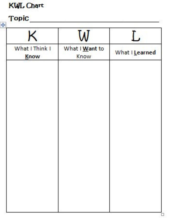
1. Students will do a APK chart about Landform Formations and tectonic plates that shape earth.
4
Posted on Authorea 25 Mar 2021 — The copyright holder is the author/funder. All rights reserved. No reuse without permission. — https://doi.org/10.22541/au.161670433.32615835/v1 — This a preprint and has not been peer reviewed. Data may be preliminary.
Figure 2: KWL Chart
2. Students before class will do a flipped classroom activity:
https://edpuzzle.com/media/605bddfca967d64274987cc7
The Lesson:
Part 1. The Underground Railroad (20 Minutes)
Introduction: Teachers and students discuss the flipped classroom video creating a virtual concept map of
the underground railroad in groups of 2- 3 students.
Part 2. North American Landforms (30 Minutes)
5
Posted on Authorea 25 Mar 2021 — The copyright holder is the author/funder. All rights reserved. No reuse without permission. — https://doi.org/10.22541/au.161670433.32615835/v1 — This a preprint and has not been peer reviewed. Data may be preliminary.
Students will explore the North America topographical map and complete the following worksheet of: What
tectonic processes are most responsible for shaping North America?
Worksheet Lab: What tectonic processes are most responsible for shaping North America?
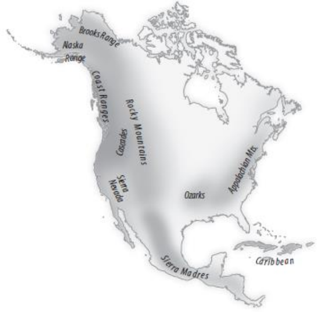
Mountains are important structures of the North American landscape. By studying the types of mountains,
scientists can figure out what processes have shaped the continent over the last several hundred million years.
Before scientists can make conclusions about the formation of a continent, they have to know what happened
it all of its parts. Scientists research information so they can answer questions and draw conclusions about
the continent as a whole.
1. Study the map shown.
Figure 3: Map of North American Mountain Ranges
2. Research North American mountain ranges. Answer the following questions for each mountain range in
the map shown below, and include any other information you find interesting.
* What is the name and location of your mountain range?
* What type of plate boundary is near your mountain range?
Skill Practice continued
6
Posted on Authorea 25 Mar 2021 — The copyright holder is the author/funder. All rights reserved. No reuse without permission. — https://doi.org/10.22541/au.161670433.32615835/v1 — This a preprint and has not been peer reviewed. Data may be preliminary.
* What tectonic plates form the boundary near your mountain range?
* What type(s) of mountains make up your mountain range?
* How did the mountains form?
* What type(s) of rocks make up the mountains?
* How tall are the mountains in your range?
* How old is your mountain range?
* What other factors have affected the height or the shape of the mountains?
3. Create a visual PPT with images about the mountain ranges you researched. Include photographs or
sketches to support your research.
4. Compare and Contrast How are the mountain ranges similar? How are they different?
5. Identify What forces have shaped North America?
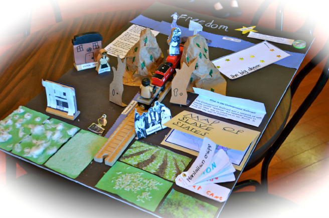
Part 3. The Challenge (60 - 180 Minutes)
Students will create a model in groups of 2-3 students ( Same groups as Part 1) representing the Map of the
United States with its mountain ranges and landforms. They will label in their 3D model that can be done
in 3D program as well, the following:
• 4 main routes – loose system of routes 1. North along Mississippi and Ohio Rivers to north 2. South
to Florida and Bahamas; 3. West into Mexico along the Gulf; and 4. East along coast Canada
• 29 states including: Kansas, Iowa, Wisconsin, Illinois, Michigan, Indiana, Ohio, Pennsylvania, New
York, Vermont, Maine, Massachusetts, Connecticut, New Jersey, Delaware, DC, Maryland, Virginia,
West Virginia, Florida, Colorado
• Mexico, Canada, Caribbean
• Color-code free states versus slave states
• Create a key
• Taking into account the routes previously taken trace in color blue a route you would have taken to
reach freedom that slaves at the time didn’t take. Use google earth to see any challenges you may have
along the way.
You may try this alternate routes:
- Start in Montgomery, Alabama; go through Philadelphia, Pennsylvania, stopping in Toronto, Ontario,
Canada.
7
Posted on Authorea 25 Mar 2021 — The copyright holder is the author/funder. All rights reserved. No reuse without permission. — https://doi.org/10.22541/au.161670433.32615835/v1 — This a preprint and has not been peer reviewed. Data may be preliminary.
- Start in Richmond, Virginia; go through Philadelphia, Pennsylvania, stopping in Montreal, Quebec,
Canada.
- Start in Savannah, Georgia; go through Philadelphia, Pennsylvania, stopping in St. Catharines, Ontario,
Canada.
- Start in Jackson, Mississippi; go through Detroit, Michigan, stopping in Windsor, Ontario, Canada.
Take into account the following details of your escape route:
- Is the path the shortest route?
- What rivers did you cross or travel near?
- What cities would you stop in?
- How long do you think your journey would take?
Figure 4: Model Example
Homework and Lesson Assessment Wrap Up:
Write a 3 paragraph individual essay answering the following questions:
Did the shape and landforms of North America influence the decision of the Underground Railroad Conduc-
tors to use the routes they did to escape to freedom? Why or Why not? Explain your reasoning.
8
Posted on Authorea 25 Mar 2021 — The copyright holder is the author/funder. All rights reserved. No reuse without permission. — https://doi.org/10.22541/au.161670433.32615835/v1 — This a preprint and has not been peer reviewed. Data may be preliminary.
9
